
by Harvey Leifert Wednesday, July 30, 2014
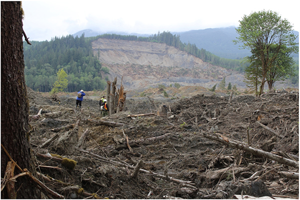
The Oso landslide killed 43 people. Credit: GEER team.
Early on March 22, 2014, the most damaging landslide in U.S. history devastated the community of Oso, Wash. Forty-three people perished, most inside their homes, when a saturated hillside nearby gave way and a massive mudflow swept over their neighborhood. On July 22, a search crew recovered the last of the 43 bodies, exactly four months after the landslide, and coincidentally on the same day that a team of scientists and engineers released an exhaustive report (read pdf here) detailing the event and its implications.
The investigators, headed by Jeffrey Keaton of AMEC Americas and Joseph Wartman of the University of Washington, described their findings during a conference call with the media. Based on field observations collected over a four-day period in May and carbon dating of ancient trees exposed in the scarp near the head of the landslide, the scientists determined that the landslide was just the latest in a string of comparable events in the nearby hills dating back at least 6,000 years. The most recent had occurred in 2006 on the same slope and may have “set up” the 2014 slide by leaving the hillside unstable, the scientists said.
The scientific team was mobilized by Geotechnical Extreme Events Reconnaissance (GEER), a National Science Foundation-sponsored organization that collects time-sensitive onsite data immediately following disasters caused by earthquakes, floods, hurricanes, landslides and other natural phenomena worldwide. Along with observations gathered on the ground, the researchers also relied on lidar imagery, seismic records, U.S. Geological Survey (USGS) stream gauge readings and other data in their analysis.
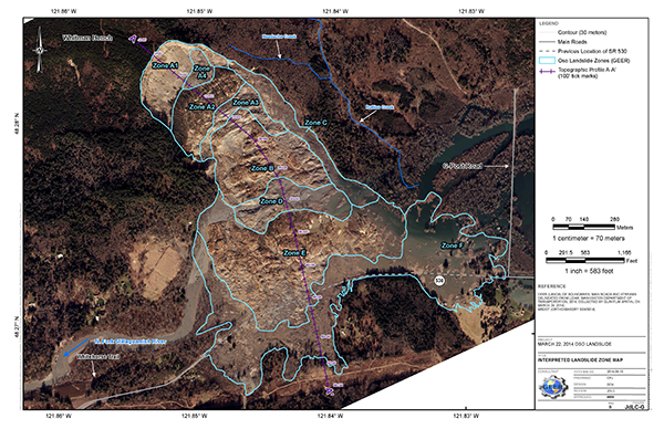
Map of the Oso landslide that shows the different zones the GEER team defined and studied. Credit: GEER team.
In addition to the 43 lives, the landslide claimed about 50 homes and injured another 10 people. Eyewitness survivors in the decimated area described a wall of mud, perhaps 8 meters high, racing across the valley toward them with the sound of freight trains, plane crashes and “tens of thousands of things hitting each other.” State highway 530 was closed for two months, and Washington state has estimated capital losses at $50 million or more.
Policymakers are interested in knowing whether this event could have been predicted and what the implications are for other communities established in the shadow of potentially unstable hills.
Oso lies within the Cascade Range province, north of Seattle. The mountainous area is marked by large valleys, ridges and sharp peaks. The town lies in a relatively narrow valley on the banks of the North Fork Stillaguamish River, which flows westward toward Puget Sound.
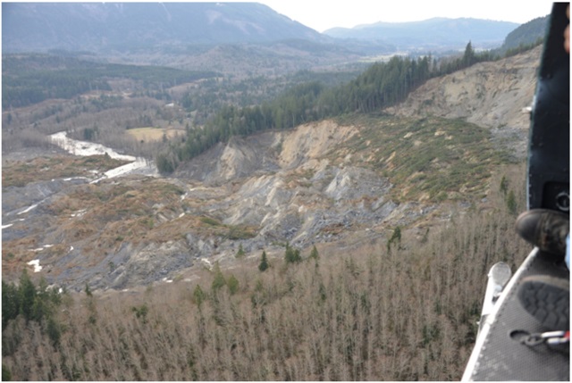
Rotational block field of Zone B as seen from the air looking west on March 24. Credit: Eric Jensen, King County Sheriff Department.
The 2014 landslide occurred in two distinct stages, the new report noted. The first was recorded by nearby seismic stations at 10:37:22 a.m. and the second at 10:41:53 a.m. A review of regional seismic activity in the weeks prior to the disaster showed that just one magnitude-1.1 event had occurred, which the scientists judged too small to have triggered the landslide. Speculation has arisen in the community that logging activity in the region might have played a role in the landslide, but the scientists said that even though it’s possible logging could have influenced slope stability in the area, there is no clear evidence that it played a role in the Oso landslide. They also noted that ancient landslides had occurred nearby without any logging beforehand.
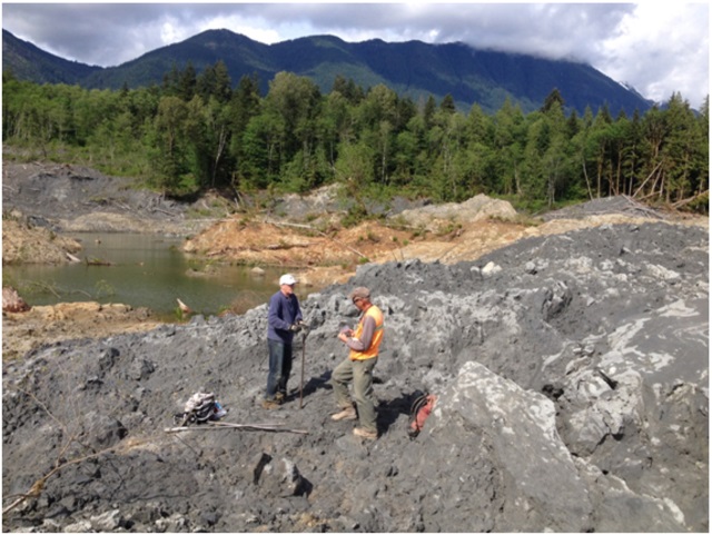
Researchers used hand augers to drill into lacustrine material in Zone D. Credit: GEER team.
Rather, the investigators focused on local rainfall records. It was not raining in Oso on March 22, but precipitation in the region had been well above average in the weeks prior. Excessive water seeping into the hillside from rain and changes in groundwater flow may have weakened the slope, Wartman suggested. Keaton added that the landslide may have begun moving as a solid, subsequently liquefying as it gained momentum. In a separate press statement, Keaton noted, however, that although rainfall had been heavy throughout the region and some slope instability had occurred near railroad tracks, no other landslides were reported in Snohomish County or the Seattle area this past spring.
In the GEER report, the authors stress that their data, which they have made freely available, may be subject to other interpretations, which they invite. And other researchers have noted such differing interpretations of how the landslide played out. In one such response, Richard Iverson of USGS has said that detailed analysis of the seismic data suggests that most of the damage was actually caused by the first landslide episode, with the second event being much smaller and less damaging.
The GEER team also reported that the first landslide did all of the damage, but that the second slide, albeit smaller, was also large. It ran into the trailing edge of the first slide and stopped, Keaton told EARTH. The seismic signals indicate two main pulses of sliding, he says; onsite observations of the debris field underlay the scenario described in the report.
Determining the immediate cause of the slide was not even a primary objective of the investigative effort, according to GEER. Rather, the main goal was to document field conditions that would become obscured or otherwise lost for observation in the future, Keaton says. The data collected by the GEER team are available to anyone who is interested, particularly researchers, he says. In addition, the findings may provide policymakers with information that could be used to prevent similar disasters elsewhere.
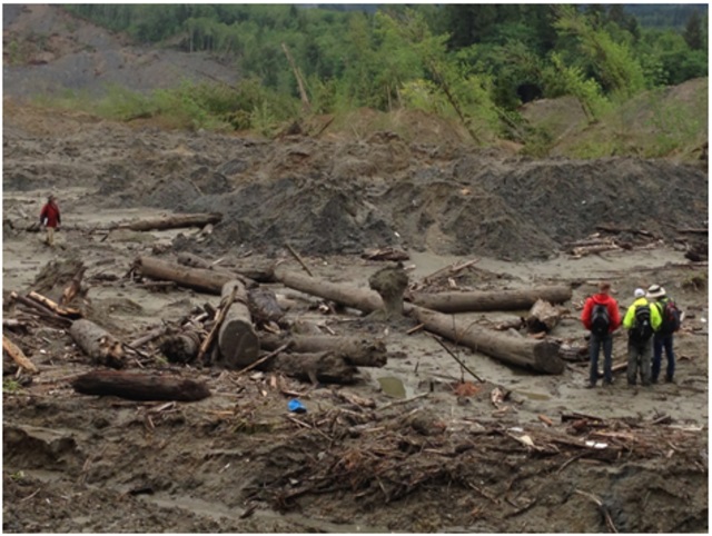
Revetment logs have metal identification tags and holes drilled and filled with steel cables being examined by GEER team members on May 23. Credit: GEER team.
In response to a question posed by EARTH during the media briefing about lessons that mayors or city councils from other valley towns could take from the Oso event, Keaton acknowledged that it’s unclear just yet. It’s “the question of the century,” he said, adding that scientists cannot say for sure that Oso is now any safer than before the March 22 landslide.
At the American Geophysical Union’s Science Policy Conference in Washington, D.C., in June, Wartman had presented a preliminary version of the team’s report, noting at that time that at least six of the homes destroyed in Oso were built after 2006. They conformed to local regulations regarding proximity to landslide hazards, because it had not been foreseen that debris runoff could extend as far as it did. There is currently no national standard quantifying landscape risk, he said.
GEER member David Montgomery, a geomorphologist at the University of Washington, noted during the July 22 briefing that the report tries to put real numbers on the risk in the Oso slide area. “If we are actually going to be able to realistically advise communities and homeowners of the magnitude of the risk that they run by living in certain places on the landscape,” he said, we need to know the nature and likelihood of the hazards in those places. “So we need to be able to identify both the landslide source zones and the style of landsliding and the risk - how frequently you might expect those risks to happen.” Best estimates of large landslide frequency in the valley near the Oso landslide is 400 to 5,000 years, Keaton adds.
Additionally, Montgomery said, we need to understand the history of landsliding in places. The ancient slides and the recent ones, up to 2006, all contributed to the 2014 Oso event, he said. Doing the studies and putting numbers on risks in advance “is the way to actually make informed policy decisions.”
© 2008-2021. All rights reserved. Any copying, redistribution or retransmission of any of the contents of this service without the expressed written permission of the American Geosciences Institute is expressly prohibited. Click here for all copyright requests.