
by Doug Prose Wednesday, May 2, 2018
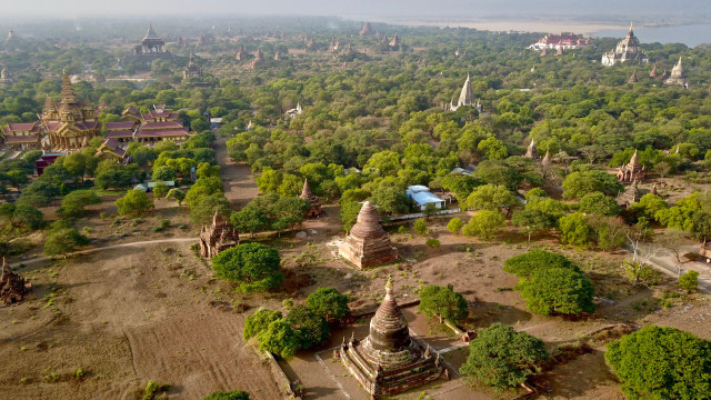
Some 10,000 temples and pagodas — built in the 11th, 12th and 13th centuries — used to stand in what's now the Bagan Archaeological Zone along the Irawaddy River in Myanmar. About 2,200 of the structures remain today. Credit: Doug Prose
Doug Prose, formerly a geologist with the U.S. Geological Survey, has co-produced documentaries showcasing Earth and the geosciences with his partner and wife, Diane LaMacchia, through their nonprofit Earth Images Foundation since 1992. Recent films include “Earth: The Inside Story” and “Italy’s Mystery Mountains,” both released in 2014. Their latest documentary, “The Himalaya Connection,” began airing on PBS stations in April. Prose has previously written and blogged for EARTH about the pair’s experience shooting and preparing “Connection,” which involved six separate trips to Bangladesh, Bhutan, India, Mongolia and Nepal from 2011 to 2016. They recently traveled back to the region for their next project. Prose wrote about the trip while there, and filed the following series of posts upon returning home. Read posts in this series, as well as from prior trips, here.
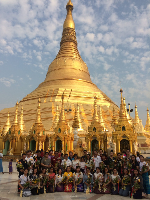
The ornate Shwedagon Pagoda stands 100 meters tall in Yangon and attracts crowds of pilgrims and tourists. Credit: Doug Prose
Several things make an instant impression as we exit the airport in Yangon, Myanmar, on April 2. Where are the motorbikes? They are almost nonexistent on the busy city streets! Not only that, the vehicles that are on the roads stay strictly within the lanes painted, and everyone stops and goes as directed at traffic lights hung at every intersection. No one beeps their horn. Such orderly roadways are rare in Asia in my experience, and I sort of miss the jumble. We’re told that, in Myanmar, this organization is a derivative of half a century of military rule before a general election held in 2011 began the official transition to democracy.
Diane and I are here to film geologic and cultural features ahead of a geologic expedition that will soon deploy a line of seismometers and GPS stations across the eastern part of the Burma Arc subduction zone. This National Science Foundation-funded study is headed by Michael Steckler and Leonardo Seeber of Columbia University’s Lamont-Doherty Earth Observatory, and involves geologists from the U.S., Myanmar, Bangladesh, India, Singapore, Denmark and Norway. It is one of the pioneering international science collaborations undertaken since Myanmar, formerly named Burma, opened its borders to outsiders.
Much of Myanmar consists of a wide, flat basin, the Burma Basin, which is bordered to the west by the Indo-Burma Range — where we just came from and where Aizawl lies. The basin is also cut by several major, active faults, most notably the dangerous strike-slip Sagaing Fault, which runs north-south from offshore Yangon into the north-central part of the country. The Sagaing Fault is so active that it generated six earthquakes greater than magnitude 7 between 1930 and 1956. Movement of the subducting Indian Plate below Myanmar also generates big, deep quakes, like the magnitude-6.8 Bagan Earthquake on Aug. 24, 2016, which damaged more than 200 ancient temples in the stunning Bagan Archaeological Zone. We’re going there tomorrow to film but we have time this afternoon to film the massive, gold-plated Shwedagon Pagoda in downtown Yangon. The radiance of the ornate, 100-meter-tall pagoda, and the intricacy and numbers of the diverse religious artifacts around its base, are astounding. Thousands of barefoot pilgrims and tourists circumambulating the site are, like us, awestruck and hushed.
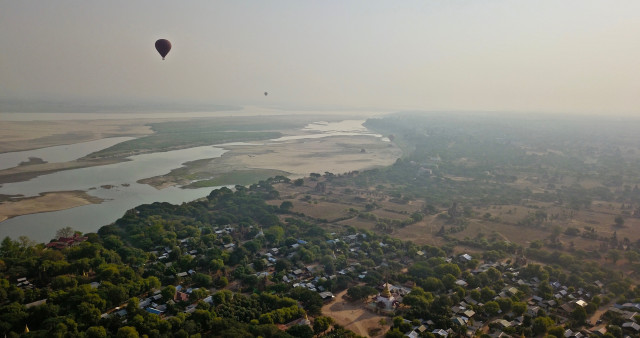
Hot air balloons rise over the Irawaddy River and Old Bagan Village. Credit: Doug Prose
The next day we take a one-hour prop plane flight to Bagan, about 500 kilometers north of Yangon. Our hotel is situated strategically alongside one of our filming objectives: the Irawaddy River. This river, whose waters are Himalayan-born, is Myanmar’s largest and most important. Here in Bagan, it skirts the west side of the surrounding valley. The river is wide and beset with huge sandbars during this dry time of the year, but it swells enormously in volume during the monsoon. I’d love to see it roar in full flow!
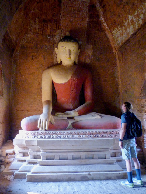
Bagan's temples and pagodas contain numerous statues of Buddha, often painted in shades of gold, white, black and red. Credit: Diane LaMacchia
In the afternoon we take a flat-bottomed motorboat out on the now-serene water to film, and find ourselves surrounded by dozens of tourists who were shuttled out to watch the sunset. The sky is an interesting shade of hazy orange-brown, but the sun set out of view behind smoke and clouds.
At dawn the next morning, we watch a dozen balloons take off and land from the river’s edge, flying riders over the Bagan Archaeological Zone, where some 10,000 closely-spaced Buddhist temples and pagodas were built by kings and wealthy families in the 11th, 12th and 13th centuries. (About 2,200 of these remain today.) The flight is a pricey $350 (U.S.) and lasts about 45 minutes. After breakfast our driver, Zuu, takes us about 60 kilometers to a subduction-created volcano called Mount Popa, which rises 1,500 meters out of the valley. A volcanic plug named Taung Kalat — which is itself often mistakenly called Mount Popa — juts dramatically a few hundred meters into the sky from the flank of the larger volcano, and is capped with beautiful gold temples.
Along with hundreds of cheerful Burmese visitors and troops of chattering monkeys, we climb the 777 steps (the higher 350 steps barefoot, as required) to the top of Taung Kalat, where it is said that the 37 “nats” — important animist spirit entities in the local tradition — like to spend time. The view across to the top of the Mount Popa caldera from here is stunning, unfiltered by the smoke pooled in the valley below.
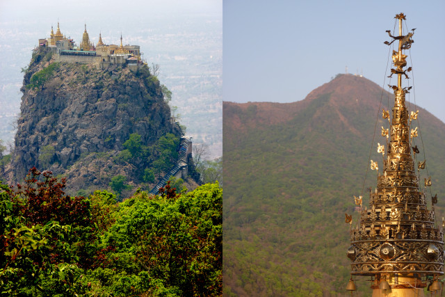
(Left) Taung Kalat, a volcanic plug adorned with golden temples, rises dramatically from the flank of Mount Popa. (Right) The summit of Mount Popa, one of the few volcanoes atop the Burma Arc, is seen here from a temple atop Taung Kalat. Credit: both: Diane LaMacchia
Because Mount Popa is so culturally important, it has been preserved as a park, and a wonderful trail leads to the summit through dense, undisturbed forest. Halfway up, we encounter an undergraduate geology class from Dagon University. The students are in very high spirits. They drove 10 hours to Mount Popa from Yangon, packed in the back of a small truck, to take this hike. What a fine field trip! They are fortunate to walk on one of just a handful of volcanoes overlying the Burma Arc. Why there are so few volcanoes here, despite the great volume of water-saturated sediments entering the subduction zone to the east, below the Ganges-Brahmaputra river delta in Bangladesh — which should seemingly promote volcanism at the surface — is a key question that the international geologic expedition coming to work here will be trying to answer.
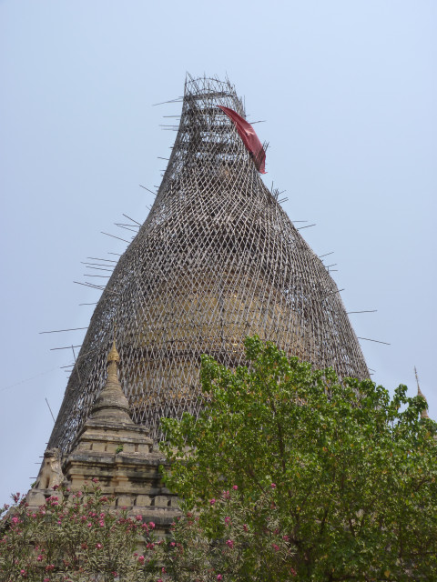
Hundreds of temples and pagodas near Bagan were damaged in a 2016 earthquake. Here, repairs are underway on one such damaged structure. Credit: Diane LaMacchia
From the summit of Popa, there is a fine view down into the caldera, which last erupted in the early Holocene, about 8,000 to 10,000 years ago. A massive complex of transmission towers degrades the summit visually, but there is a pleasant golden pagoda sitting incongruously amongst the steel and wire apparatus of modern communication.
It’s April 5 — our next-to-last day of filming on this trip — and it’s time to shoot the famed temples of Bagan and the earthquake damage they sustained in the 2016 earthquake. That strong jolt was only one of many that have shaken the area since the temples and pagodas were built centuries ago. We rent e-bikes to efficiently (and cheaply, about $3.50 for the day) zip around the valley filming them. Most of the sites have no visitors and are reached by dirt roads or trails, while the large ones are crowded with monks, pilgrims and a few tourists. They all contain one or more huge, beautiful statues of Buddha within, elaborately painted in gold, white, black and red paint. Most of the earthquake damage was focused on the tall central spires of the pagodas, built of red brick, and major efforts are being made to mend the damage, as this area is the nascent Myanmar tourism industry’s premier site. We feel so fortunate to experience and film this magical place while it’s still uncrowded and intimately accessible.
© 2008-2021. All rights reserved. Any copying, redistribution or retransmission of any of the contents of this service without the expressed written permission of the American Geosciences Institute is expressly prohibited. Click here for all copyright requests.