
by Rachel Crowell Thursday, January 17, 2019
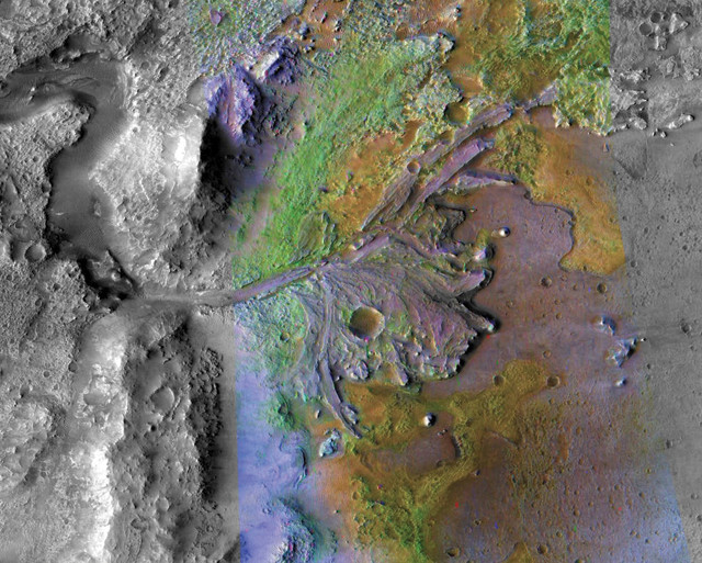
An ancient, water-carved delta in Jezero Crater — the landing site chosen for the Mars 2020 rover mission — is seen in this false color image taken by the Mars Reconnaissance Orbiter. Credit: NASA/JPL/JHUAPL/MSSS/Brown University.
NASA has sent four rovers to Mars, and the fifth — the Mars 2020 Rover — is slated to launch in summer 2020 for an early 2021 arrival. Selecting suitable landing sites is a critical and painstaking pre-launch step in ensuring both the technical and scientific success of these missions.
The selection process for the 2020 mission, for example, was a five-year-long, multistage process involving input from hundreds of scientists and engineers who investigated dozens of candidate sites and helped NASA ultimately decide, in November, on Jezero Crater as the site for the rover’s primary mission.
To aid in landing site selection for potential future missions, researchers are developing software tools that can assimilate large amounts of geologic and other data to more quickly assess site feasibilities all over the planet. And in a recent study, published in Earth and Space Science, scientists demonstrated the capabilities of their software. The project is part of a larger effort “exploring ways computers can help humans make discoveries,” says Victor Pankratius, a computer scientist at MIT’s Kavli Institute for Astrophysics and Space Research and the principal investigator for the project.
The new study is the “first planet-wide study that attempts to quantify our ability to explore Mars in a systemic and optimal fashion that includes technical and scientific constraints,” wrote Pankratius and his colleague, Guillaume Rongier, a numerical geologist at CSIRO in Australia. The researchers considered a mission similar to that of the Mars 2020 Rover, which, based on engineering constraints, is aiming “for horizontal, even and dust-free areas at low elevation in equatorial regions,” they noted, and, scientifically, is focused on “visiting an ancient habitable site with magmatic outcrops nearby, to gain better insight on the evolution of Mars.”
“Fuzzy logic” and the “fast marching method” — both computer science concepts — are central to the calculations in the team’s software.
In fuzzy logic, a statement doesn’t necessarily have to be true or false. Instead, the “truthfulness” of a proposition falls on a scale from zero to one, with zero constituting a totally false statement and one constituting a totally true one. The team converted topographic data into raster maps. “A raster is a grid of pixels, just like a regular photo from a camera,” says Rongier, who was a postdoctoral researcher at MIT during the study. Using the method, he and Pankratius then used fuzzy logic to evaluate the suitability of landing sites, culminating in a favorability map based on a scale of zero (highly unfavorable) to one (highly favorable).
Meanwhile, the fast marching method allowed the researchers to simulate the rover’s mobility as it moves through various terrain types at different speeds. In this application, the method was used to estimate the rover’s travel time to specific targets and determine if local terrain was traversable within the time allotted for a given mission.
The team’s results indicated that one-third of Mars’ surface meets the landing constraints for the Mars 2020 Rover mission, but in some of these areas, traversable paths are absent. The heavily cratered Eastern Margaritifer Terra and hematite-rich Meridiani Planum, both in Mars’ southern hemisphere, “stand out as the only highly favorable areas,” the team wrote. Those areas are well-suited as landing sites due to the high density of scientific targets and the flatness of the regions. “However, a more local study using data at finer resolution and more recent geological mapping” is needed before the team can judge the suitability of potential landing sites, they noted.
The study “critically brings together the application of modern machine learning and artificial intelligence to study Martian geology,” says Chris Mattmann, a data scientist at NASA’s Jet Propulsion Laboratory in Pasadena, Calif., who was not involved with the study. “Such a capability will be critical to flight and mission planning where the number of inputs and potential outputs to these [site] evaluations becomes too voluminous to explore without computer-assisted help,” he says.
© 2008-2021. All rights reserved. Any copying, redistribution or retransmission of any of the contents of this service without the expressed written permission of the American Geosciences Institute is expressly prohibited. Click here for all copyright requests.