
by Jennifer Georgek Tuesday, October 16, 2018
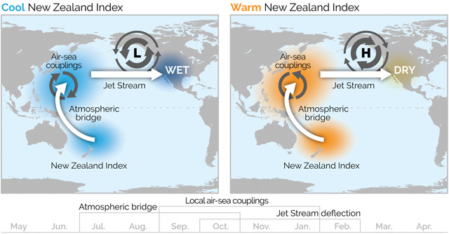
New research suggests a strong negative correlation between fall sea-surface temperatures off the north coast of New Zealand and winter precipitation in the southwestern U.S. If, for example, there are lower-than-normal sea-surface temperatures north of New Zealand, there is a much higher chance for a wet winter in Southern California and the southwestern U.S. Credit: K. Cantner, AGI, after Mamalakis et al., Nature Communications, June 2018.
Water supplies in the southwestern United States largely depend on winter precipitation. Predicting seasonal rain and snowfall is becoming more difficult, however, as climate change causes precipitation patterns to vary. A new study provides evidence of a strong correlation between late-summer to fall sea-surface temperatures off the coast of New Zealand and winter precipitation in the southwestern U.S. — a correlation that could help provide earlier and more reliable forecasts for the southwestern U.S., and improve water resource and ecosystem management in the region.
The predictability of the effects of the El Niño-Southern Oscillation (ENSO) — and other established teleconnections such as the Pacific Decadal Oscillation (PDO), the Interdecadal Pacific Oscillation, the Atlantic Multidecadal Oscillation, and atmospheric high-pressure ridges over the Gulf of Alaska — on seasonal precipitation in the southwestern U.S. is limited. “In much of the southwestern U.S., there are major important variations in precipitation which have previously been loosely associated with El Niño events,” says Kevin Trenberth, a senior scientist at the National Center for Atmospheric Research in Boulder, Colo., who was not involved in the study. “Previous studies have indeed found that this New Zealand region is unique and plays a very strong role in the evolution of ENSO and the PDO,” he says, but “this [study] is important in highlighting some long-distance teleconnections that have not been well explored previously.”
In the new research, published in Nature Communications, Antonios Mamalakis, a doctoral candidate at the University of California, Irvine, and colleagues explored whether undiscovered teleconnections could influence southwestern U.S. precipitation. “We did not restrict ourselves [to] looking only [at] tropical Pacific sea-surface temperatures; our diagnostic analysis was global,” Mamalakis says. The team evaluated relationships from 1950 to 2015 between winter (November – March) precipitation amounts in Arizona, California, Nevada and Utah and both global monthly sea-surface temperature data and geopotential height (GPH) reanalysis data for late summer (July – September) and fall (September – November). “GPH represents the height from Earth’s surface to reach a specific value, or level, of atmospheric pressure,” Mamalakis says. They looked at GPH data because “sea-surface temperature correlates positively with GPH … GPH is lower over colder water, and higher over warmer water,” he says.
The team found a strong negative correlation between fall sea-surface temperatures off the north coast of New Zealand and winter precipitation in the southwestern U.S. — a correlation that was shown to be strongest over the past 40 years. “This means that in years we had lower-than-normal sea-surface temperatures in New Zealand, we had a much higher chance to have wet winters in Southern California and the southwestern U.S.,” while warmer-than-normal sea-surface temperatures off New Zealand correlated with higher odds of dry winters in the southwestern U.S., Mamalakis says. That is “the same strong correlation we found using GPH, which provided confidence in our findings,” he adds. Mamalakis and colleagues refer to this teleconnection as the New Zealand Index (NZI).
The team suggests that above, or below, average sea-surface temperatures near New Zealand can weaken, or strengthen, the Hadley cell (a large-scale atmospheric circulation pattern that circulates air from the tropics to mid-latitudes). This introduces anomalous temperatures in the northern and central Pacific, which can then reposition storm tracks controlling the amount of precipitation received in the southwestern U.S.
However, Trenberth says, the GPH reanalysis data used in the study are questionable because the reanalysis was constructed only from surface data — it doesn’t include information about winds, or upper atmospheric conditions from radiosonde data, balloon sounding data, or satellite data. “There are much more detailed and more credible reconstructions of what has happened in the atmosphere … but it’s difficult to go back before about 1979.” So he says he understands why the researchers used these data. “But in terms of reconstructing important ingredients that go into this [atmospheric record], they might be missing a little bit,” he adds.
“This [study] sort of demands a follow-up to explore how and why this [teleconnection] is happening,” Trenberth says, “and how this relationship might be exploited to give better guidance as to what’s happening in California and a little farther to the east. That information could be very valuable to a lot of people.”
© 2008-2021. All rights reserved. Any copying, redistribution or retransmission of any of the contents of this service without the expressed written permission of the American Geosciences Institute is expressly prohibited. Click here for all copyright requests.