
by Mary Caperton Morton Tuesday, May 1, 2018
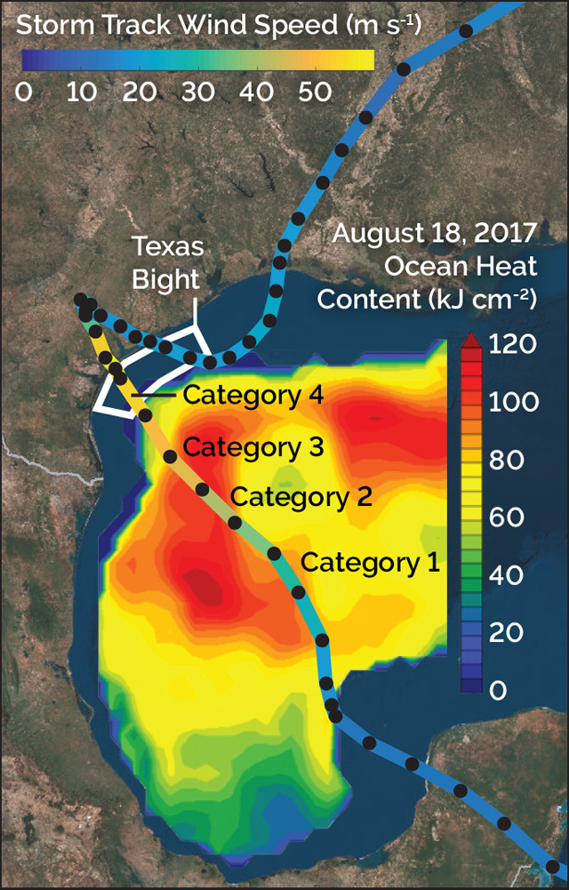
Harvey rapidly intensified from a tropical storm to a Category 4 hurricane as it moved across the Gulf of Mexico. Warmer colors indicate higher ocean temperatures in the Gulf, and higher wind speeds on the storm track. Credit: K. Cantner, AGI , with data from UODL and Potter et al.
Last August, Hurricane Harvey walloped Texas, dropping more than 100 centimeters of rain on Houston and nearby areas, and causing more than $125 billion in damage. But almost nobody saw it coming. In the days before Harvey made landfall 60 kilometers east of Corpus Christi, the tropical storm barely registered as a threat, but within 30 hours it escalated from a tropical storm into a Category 4 hurricane. Using data collected before and during the storm, scientists are piecing together how Harvey became so ferocious so fast, an effort that could help scientists better predict which future storms might have similarly rapid intensifications.
Two weeks before Harvey hit, researchers from Texas A&M University conducted a hydrographic survey of the shallow waters of the Texas Bight just off the coast near Corpus Christi. “This was part of an unrelated project to study water quality, but it gave us some very interesting and valuable data about how much heat was available in coastal waters leading up to the storm,” says Henry Potter, an oceanographer at Texas A&M, who presented his findings at the 2018 Ocean Sciences meeting in February in Portland, Ore.
The team found that the average water temperature across the bight in August was 28.3 degrees Celsius, 1.8 degrees warmer than it had been in June, when the prior survey was conducted. “That’s essentially bathwater, all the way down to the bottom,” Potter says.
Ocean temperatures are usually estimated from satellite data, which has upsides and downsides, Potter says. Such measurements tell you how much heat is in a body of water, “but you don’t know where it’s located in the water column,” he says. “The benefit of [the hydrographic] dataset is that we knew exactly where the heat was and how much was there, which gave us some really good information about the heat available to drive Harvey.”
In general, warmer water begets stronger hurricanes. “If the water temperature is above 26 degrees Celsius, then it’s probably warmer than the atmosphere, which means that heat goes from the ocean into the atmosphere … which drives the hurricane,” Potter says. Despite the high water temperatures in the bight prior to Harvey, the calculated values of Tropical Cyclone Heat Potential (TCHP) — a metric used to predict whether a tropical storm will intensify into a hurricane — weren’t notably strong. Regions with a TCHP above 90 kilojoules per square centimeter (kJ/cm2) have previously been associated with rapidly intensifying storms, but the TCHP of the Texas Bight was only about 35 kJ/cm2. This suggests that “the TCHP may not be a good metric to use in shallow water, like [off] the coast of Texas,” Potter says.
But the heat that drove Harvey to intensify so quickly could have also come from farther offshore, says Nick Shay, an oceanographer at the University of Miami who was not involved in the new study. “Harvey may have gotten a little jolt over the warm slug of coastal waters, but, by and large, it got most of its warm water boost earlier over a big ‘warm-core’ eddy that was moving across the Gulf.”
This pattern is not unique to Harvey, he says. “We’ve seen this interaction many times. This warm-core eddy is often present in the Gulf during the summer months, throughout the hurricane season, and when storms encounter it, they sometimes explode.”
But even though this pattern has been seen in previous hurricanes — such as Opal in 1995, which escalated from a Category 1 to a Category 4 in less than 14 hours — models still struggle to take the warm Gulf eddy into account when predicting which storms will escalate. “Our predictive models are still failing to detect when rapid intensification may kick in,” Shay says. “A better understanding of what triggers the onset of rapid intensification is crucial for hurricane research. Coping with rapidly intensifying storms represents a real challenge for emergency managers and local and state governments.”
Scientists only have detailed data coverage — gathered from instrumented probes deployed from hurricane hunting aircraft and ships — during the period that Harvey escalated from a Category 3 to a Category 4. “A lot of funding goes into making models, but we need good data to put into those models,” he says.
During future storms, deploying more expendable probes, gathering in situ data from floats and buoys, as well as increasing monitoring from satellites may help give scientists the data they need to more accurately predict whether a relatively benign tropical storm will grow into a dangerous hurricane. “This type of rapidly intensifying storm track could certainly be a repeatable event, especially in the high summer heat of the Gulf hurricane season,” Potter says.
© 2008-2021. All rights reserved. Any copying, redistribution or retransmission of any of the contents of this service without the expressed written permission of the American Geosciences Institute is expressly prohibited. Click here for all copyright requests.