
by The American Geosciences Institute Thursday, October 1, 2015
Scroll down for the answer
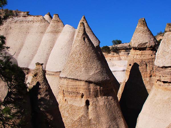
The pointed hoodoos of this national monument are formed from layers of pumice, tuff, ash and conglomerates that were originally deposited more than 300 meters deep in some places by Late Miocene volcanic eruptions.
Small weather-resistant boulders helped create the distinct shape (likely familiar to hikers) of the formations, which range in height from about a meter up to about 27 meters, as softer rock below the caprocks eroded.
Archaeological evidence suggests humans inhabited the area 4,000 years ago. The indigenous name for the area translates to “white cliffs,” likely a reference to ledges lining the steep-sided canyons also found in this area, which was designated a national monument in 2001.
Scroll down for the answer
Answer: The pointed hoodoos of Kasha-Katuwe Tent Rocks National Monument are formed from layers of pumice, tuff, ash and conglomerate that were originally deposited by Late Miocene volcanic eruptions. Archaeological evidence suggests humans inhabited the area 4,000 years ago. Photo is by Garry Hayes.
October Winners: James Dukelow Jr. (Benton City, Wash.) Lawrence A. Gilbert (Dayton, Ohio) Ross Jones (Winnetka, Ill.) J. Brad Stephenson (Oak Ridge, Tenn.) Daniel Tucker (Sun Lakes, Ariz.)
Visit the ="/where-on-earth-archive">Where on Earth? archive.
EARTH also welcomes your photos to consider for the contest. Learn more about submitting photos ="/whereonearth/submit">here.
© 2008-2021. All rights reserved. Any copying, redistribution or retransmission of any of the contents of this service without the expressed written permission of the American Geosciences Institute is expressly prohibited. Click here for all copyright requests.