
by The American Geosciences Institute Friday, May 1, 2015
Scroll down for the answer
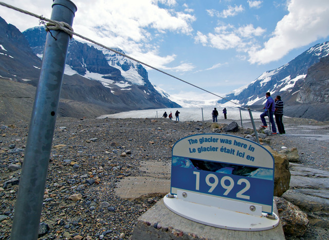
Sharing its name with a mountain peak, river, lake and town, the glacier seen in the distance here is one of six large outlets, or tongues, of a major icefield that covers roughly 300 square kilometers and straddles a continental divide.
With its proximity to a nearby highway, appropriately dubbed the “Icefields Parkway,” and easy accessibility to visitors on foot, it is thought to be the most visited glacier on its home continent.
Even though the icefield receives an average of 7 meters of snow annually and the glacial ice moves downslope at a rate of several centimeters per day, the glacier’s terminus recedes roughly 5 meters per year.
Scroll down for the answer
Answer: The Athabasca Glacier is one of six large outlets of the Columbia Icefield, which covers more than 300 square kilometers in the Canadian Rockies. Even though the icefield receives an average of 7 meters of snow annually, and the glacial ice moves downslope at a rate of several centimeters per day, the Athabasca’s terminus recedes roughly 5 meters per year. Photo is by Mary Caperton Morton. May Winners: Edith Chasen-Cerreta (Woodhaven, N.Y.) Howard R. Feldman (Scarsdale, N.Y.) Michael Finfer (Bridgewater, N.J.) Siegfried Muessig (Claremont, Calif.) George Wallerstein (Seattle, Wash.)
Visit the Where on Earth? archive.
EARTH also welcomes your photos to consider for the contest. Learn more about submitting photos here.
© 2008-2021. All rights reserved. Any copying, redistribution or retransmission of any of the contents of this service without the expressed written permission of the American Geosciences Institute is expressly prohibited. Click here for all copyright requests.