
by The American Geosciences Institute Tuesday, June 26, 2018
Click to enlarge photo
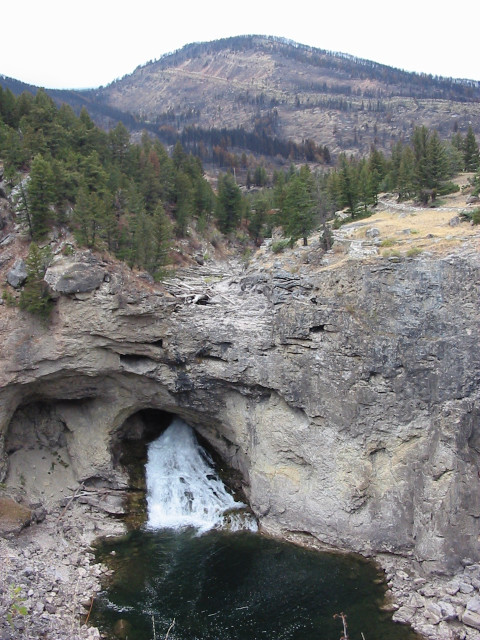
At times of low runoff (as in this picture), the river drains through a solution cavity in Paleozoic limestone. During times of high runoff, however, water fills the dry channel above the cavity, spilling over the cliff and creating a 30-meter-high waterfall.
The waterfall, located about 60 kilometers north of a colorfully named national park, was named after a nearby natural feature that collapsed in July 1988.
This river is the better known of two in the state with the same “rocky” name, and is a popular destination for hiking, camping and fishing.
Scroll down for the answer
Answer: At times of low runoff, Natural Bridge Falls in Montana, which lies about 60 kilometers north of Yellowstone National Park, drains through a solution cavity in Paleozoic limestone. At times of high runoff, the Boulder River flows over a cliff producing a 30-meter-high waterfall. Photo by Jim Sukup.
July 2018 Winners: Eric Asmussen (San Leandro, Calif.) Leslie Bright (Kingsport, Tenn.) R.J. Gauthier-Warinner (Interlochen, Mich.) Robert Kasper (Abingdon, Md.) Stephen Tomlin (Mount Evelyn, Victoria, Australia)
Visit the ‘Where on Earth?’ archive.
EARTH also welcomes your photos to consider for the contest. Learn more about submitting photos.
© 2008-2021. All rights reserved. Any copying, redistribution or retransmission of any of the contents of this service without the expressed written permission of the American Geosciences Institute is expressly prohibited. Click here for all copyright requests.