
by Mary Caperton Morton Tuesday, March 29, 2016
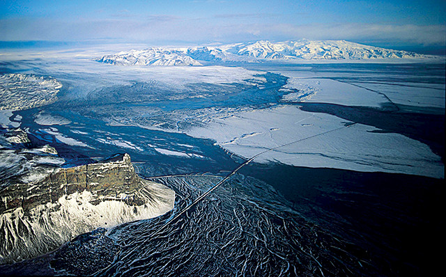
In 1996, Grímsvötn Volcano erupted beneath the Vatnajökull Ice Cap, triggering a massive glacial outburst flood, called a jökulhlaup, that discharged 300,000 cubic meters per second as it flowed across the Skeidarársandur, a glacial outwash plain on the southern coast of Iceland. Credit: USGS/Icelandic Meteorological Office, Oddur Sigurdsson.
With examples of every type of volcano on Earth, and about a third of the island’s more than 30 active volcanic systems buried under glacial ice, Iceland earns its nickname: the land of fire and ice.
The variety of volcanoes makes for a diversity of hazards, including ashfalls, earthquakes, flooding, lava flows and volcanic lightning. It also makes for a uniquely challenging environment to monitor. Iceland is sparsely populated outside of the capital, Reykjavík, but its volcanoes can affect people throughout Europe and even North America, as demonstrated by the ash cloud produced by the eruption of the Eyjafjallajökull Volcano in 2010 that grounded trans-Atlantic and European flights for nearly a week.
Keeping tabs on so many different types of volcanoes, each with their own unique eruptive patterns, presents a special challenge for the Icelandic Meteorological Office (IMO), which monitors the volcanoes using a combination of GPS, satellites, seismic stations, and river discharge and gas monitoring stations.
With so many eyes, ears and instruments on the volcanoes, and an eruption every three to four years, Iceland is also an ideal natural laboratory for studying how volcanic processes evolve over time.
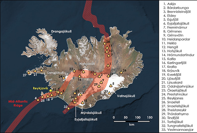
Iceland has 33 active volcanoes (named at right) and about 100 dormant and extinct volcanoes. Credit: K. Cantner, AGI.
Iceland lies at the intersection of the Arctic and North Atlantic oceans, directly atop the Mid-Atlantic Ridge, a spreading center where upwelling magma forms new crust and pushes tectonic plates apart at a rate of 2.5 centimeters a year. Magma associated with the spreading ridge drives much of the island’s volcanic activity. But not all of it.
The majority of the 16,000-kilometer-long Mid-Atlantic Ridge lies underwater, but the island of Iceland juts above the waves, rising up to 2,109 meters above sea level at the summit crater of Öraefajökull Volcano. This striking prominence hints that a secondary magma-generating process is at work under the island.
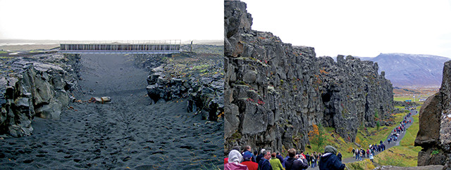
Iceland is the only place on Earth where the Mid-Atlantic Ridge breaches the surface. At Thingvellir (right), tourists can walk through an extinct fissure and at Sandvík (left), they can cross a bridge linking the North American and European plates. Credit: left: Chris73, CC BY-SA 3.0; right: P. Marshal, CC BY-SA.
“All of Iceland should be at the bottom of the sea, but it’s lifted above the water due to the Icelandic hot spot,” says Rikke Pedersen, manager of the Nordic Volcanological Center (NVC) at the University of Iceland in Reykjavík. The nature of the Icelandic hot spot is something of a mystery, however, with some camps thinking it is driven by a narrow plume originating deep in the mantle, similar to the hot spot thought to have created the Hawaiian Islands. Others instead attribute the hot spot’s enhanced magmatism to local mantle fertility fed by a subducted chunk of ancient oceanic crust.
“It’s clear that there’s a melting anomaly under Iceland that produces more melt than anywhere else along the Mid-Atlantic Ridge,” says Freysteinn Sigmundsson, a volcanologist at the University of Iceland. More research will be needed to understand the origin of this anomaly, he says, particularly seismic studies using instruments installed on the ocean floor to get a clearer picture of what lies beneath.
Whatever the source of Iceland’s prolific magma, it makes for fascinating and diverse volcanism, ranging from effusive flood basalts to explosive Plinian-type eruptions to submarine vents. “Here we have multiple melt-producing processes producing a diversity of magmas, which is why Iceland is so fascinating,” Pedersen says. “We have every kind of volcano on Earth and every kind of magma: the most fluid all the way up to very explosive. Iceland has it all.”
celand currently has 33 active volcanoes and about 100 dormant and extinct systems. As would be expected at a spreading center, effusive eruptions producing basaltic lavas predominate, but the influence of glacial ice and meltwater makes for a range of explosive eruption types as well. Most of the active volcanoes are found along the spreading ridge, which runs north to south through the country. But volcanism also runs east to west along transform faults offsetting the ridge in two arms across central and southern Iceland, where the spreading ridge takes a sharp westward turn. Fortunately, more than 70 percent of Iceland’s 330,000 inhabitants live on the southwest coast near Reykjavík, which lies just outside the margins of the active volcanic zone.
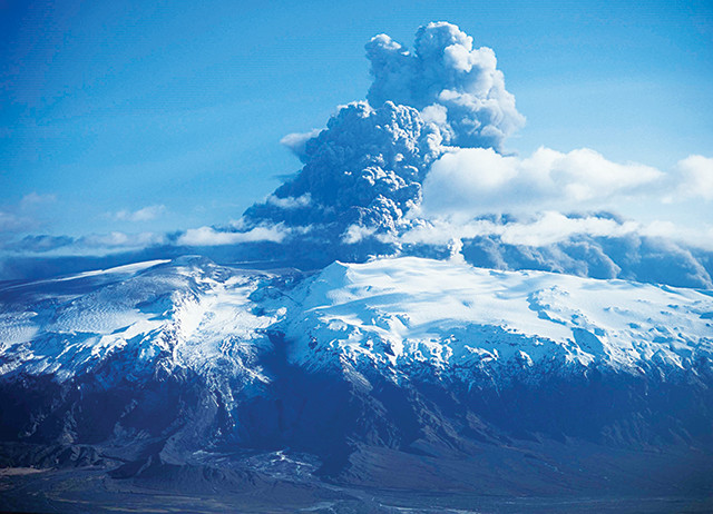
The eruption of Eyjafjallajökull Volcano in April 2010 severely impacted trans-Atlantic and European air traffic. Credit: USGS/Icelandic Meteorological Office, Oddur Sigurdsson.
The largest eruptions in Iceland’s history took place at Hveravellir in A.D. 950, Eldgjá in 954, and Laki in 1783 and 1784; each of these registered at 6 on the Volcanic Explosivity Index (VEI). Eruptions at Öraefajökull in 1362 and Askja in 1961 likely came in at 5 on the VEI. The most recent major eruptions occurred at Eyjafjallajökull in 2010, Grímsvötn in 2011, and Bárdarbunga in 2015 (see map), each of which had a VEI of 4. Due to Iceland’s low population density, especially near the volcanoes, few fatalities are directly attributed to even the largest events, with most of the few thousand volcano-related deaths in Iceland’s history caused by famines resulting from crop failures in the wake of eruptions, such as the 1783 Laki eruption, which lasted eight months and killed not only crops, but also sheep and fish.
The 2010 Eyjafjallajökull eruption is infamous for having pumped a uniquely high-flying ash into the atmosphere that grounded airplanes from North America to Europe for six days and created hazardous conditions in the airspace over Europe for nearly a month. The problem wasn’t the size of the ash plume overall, which was rather modest, but the angular — rather than rounded — shapes of the ash particles. These angular shapes allowed the particles to persist longer in the atmosphere, where they were spread far and wide by weather, threatening to damage airplane engines.
Grímsvötn is the most frequently erupting volcano in Iceland. The volcano sits under the Vatnajökull Ice Cap and is notorious for producing jökulhlaups: massive outburst floods unleashed by geothermal melting of glacial ice. In 1996, a large eruption filled Grímsvötn’s caldera with meltwater. The water was contained for several weeks before bursting through the caldera rim. The jökulhlaup reached a maximum rate of 45,000 cubic meters per second, flooding the valley and rushing across the Skeidarársandur alluvial plain, where it washed out a bridge on the ring road — the main highway around the island — and deposited building-sized icebergs. Additionally, the outburst flood washed up to 100 million metric tons of volcanic debris and sediment out to sea, creating a plume that extended 15 kilometers offshore. The 2011 Grímsvötn eruption didn’t set off a jökulhlaup, but, as with Eyjafjallajökull the preceding year, the ash cloud impacted flights to Iceland and Europe for weeks.
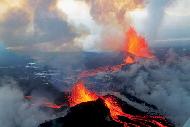
The Holuhraun eruption of Bárdarbunga Volcano continued for six months. Credit: Peter Hartree, CC BY-SA 2.0.
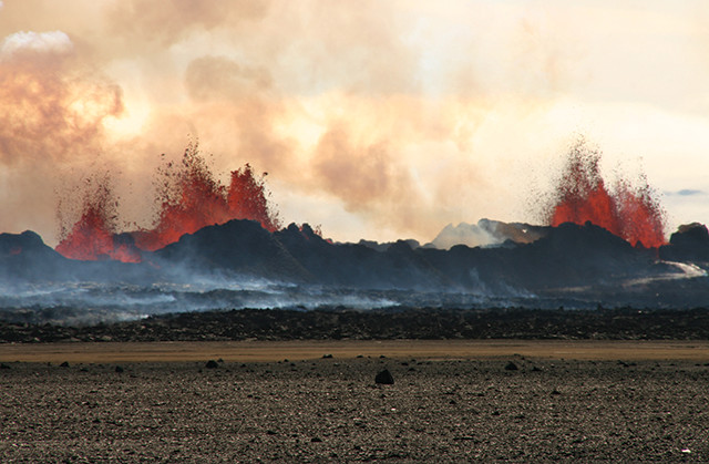
During the 2014–2015 eruption of Bárdarbunga Volcano, lava spewed from fissures in Holuhraun Lava Field to the north of the volcano. Credit: Michelle Parks, University of Iceland.
Bárdarbunga was the last active volcano in central Iceland to be discovered, when it erupted beneath the massive Vatnajökull glacier in 1910. “Bárdarbunga is a sleeping giant, hiding under one of the biggest glaciers in Iceland,” says Morten Riishuus, a volcanologist at the NVC. The 2015 eruption was one of the largest since Laki in 1783, although it produced very little ash. Instead, the six-month-long eruption created an 85-square-kilometer lava field and spewed 12 megatons of sulfur dioxide into the atmosphere. “That’s more than the total sulfur dioxide emissions from all of Europe [that same] year,” Riishuus says.
The most dangerous volcanoes in Iceland are currently considered to be Katla, Hekla and Öraefajökull (see sidebars) because “these three are capable of explosive eruptions, and Katla and Öraefajökull volcanoes are subglacial and can cause floods that may affect the main ring road around Iceland,” says Kristín Jónsdóttir, team leader of earthquake and volcano monitoring at the IMO. In addition, she adds, “Hekla has a short fuse and has in the past given very short precursory signals before eruptions. The potential hazards [for all three] are ash, floods, lightning, lava, pyroclastic flows and gas emissions, to name a few.”
The IMO, located in Reykjavík, is responsible for monitoring all 33 of Iceland’s active volcanoes. “We operate 170 instrumental monitoring stations [on these volcanoes], which relay data 24/7. It’s a lot of information from a lot of different sources,” Jónsdóttir says. The most instrumented tend to be those that have erupted more recently, like Bárdarbunga and Grímsvötn, those with short fuses, like Hekla, and those with the greatest potential for destruction, like Katla (see sidebars).
Even the most remote volcanoes, such as Askja and Kverkfjöll, both located in the barren interior of the island, are closely monitored due to their potential to release ash plumes that could impact aviation or glacial floods that could endanger people and infrastructure downstream. “The logistics of monitoring volcanoes in these remote settings are very challenging,” she says. “It’s not like there’s a power source you can just plug into. We often need to set up solar or wind power stations and then figure out how to relay the data very rapidly all the way to Reykjavík. If something’s happening, we want to know about it as soon as possible, within seconds or minutes.”
The most difficult volcanoes to monitor are those located under ice, Jónsdóttir says. Roughly one-third of Iceland’s active volcanoes are partially or entirely covered by glaciers, some more than 1,000 meters thick. Seismic instruments can be used to monitor volcanoes under ice, but the instruments need to be placed on bedrock, and, except for the occasional outcropping of exposed bedrock, that is often impossible on ice caps. Satellites can also be used to monitor deformation, but changes in ice cover can make data interpretation difficult. So instead, the researchers often turn to river monitoring.
“Oftentimes, the first sign of increased geothermal activity at one of the ice-covered volcanoes is increased flow in rivers,” Jónsdóttir says. River monitoring stations keep tabs not only on the volume of water discharged, but also the conductivity of the water. “Geothermal meltwater contains a lot of dissolved minerals, more so than rainwater, so the conductivity of the river changes when volcanic activity is elevated,” says John Stevenson, a volcanologist at the University of Edinburgh in Scotland.
The volcanoes that are not located under ice are most often monitored using a combination of seismic stations and satellite GPS, which keep watch for earthquake activity and changes in the shape of the volcano at the surface. “Volcanoes deform throughout their lifespan,” Pedersen says. “By looking at the dimensions of the surface of a volcano, we can try to infer what’s happening inside. Uplift can signal intrusion of water or new magma into the system while deflation can indicate a drop in pressure.”
Most volcanoes give some kind of advance warning that an eruption may be imminent, such as earthquake swarms, inflation of the magma chamber, or increased gas emissions, but warning times from Iceland’s volcanoes run the gamut from months to minutes.
“Each volcano has its own personality,” says Thor Thordarson, a volcanologist at the University of Iceland. “Some give ample warning, while Hekla gives us about half an hour. [For] others, we don’t have a clue what kind of warning they would give because they haven’t erupted in the past hundred years.” Katla, for example, last erupted in 1918, before there was any kind of instrumentation on the volcano. “If there’s unrest at Katla, what does it mean?” Thordarson says. “Will it erupt tomorrow? Or is it just letting off steam?”
Instrumental monitoring in Iceland has only existed for a few decades, with historical accounts of eruptions going back about 1,000 years. The earliest evidence of subaerial volcanic activity in Iceland dates to roughly 17 million years ago. “A thousand years is only a glimpse in geological history,” Pedersen says. “We simply don’t have enough data to say whether an eruptive pattern is typical for any one volcano. Nor can we say which volcanoes are overdue for eruptions. One of the ‘sleepers’ could awaken anytime.”
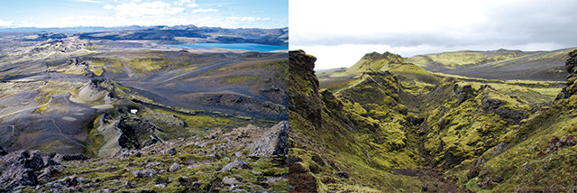
Two views of the Laki fissure: The eight-month-long eruption of Laki in 1783 and 1784 was catastrophic for the people of Iceland, as the volcanic emissions killed crops, animals and even fish. Credit: left: lan Molcho, CC BY-SA 2.0; right: Chmee2Valtameri, CC BY-SA 3.0.
In making decisions about how to distribute their monitoring resources, the IMO must weigh the more obvious threats against the sleepers. “We have a tendency to watch the volcanoes that have erupted in the recent past, but the ones that erupt infrequently may be much more of a threat because they tend to produce much bigger eruptions when they do go off,” Thordarson says.
Monitoring so many volcanoes is expensive, Thordarson says. “With a population of about 330,000, the country’s tax revenue is limited. Our volcanoes have the potential to impact Europe, but we haven’t always gotten much help from other countries.”
Fortunately, in the past three years, the IMO has gained some new eyes, ears and funds in the form of two new programs. FUTUREVOLC, led by the University of Iceland and the IMO and funded by the European Commission, is working to create a more integrated monitoring network through collaboration with other research institutions throughout Europe. Project goals include improving real-time monitoring of volcanoes, development of a Volcanic Ash Advisory Center and more seamless integration with the Civil Protection authorities in Iceland, who are in charge of carrying out evacuations when necessary.
And in 2013, Iceland was selected by the United Nations’ Group on Earth Observations as a permanent Geohazard Supersite and Natural Laboratory. The Supersite status grants researchers open access to satellite data from the European Space Agency and other satellite agencies in order to more closely monitor ground deformation at Iceland’s active volcanoes.
“The FUTUREVOLC and Supersite projects are very complementary,” says Michelle Parks, a volcanologist at the University of Iceland. “They’ve given us a greatly expanded monitoring network and a vast amount of satellite data.”
The programs have also boosted collaboration between teams of scientists in Iceland and beyond, Sigmundsson says. “We’ve been able to combine lines of research from many different teams to interpret changes in volcano behavior and use that information to provide the best possible timely advice to Civil Protection,” he says. “It’s become a model collaboration for hazard management in other countries as well.”
Iceland’s volcanoes may be some of the most closely watched in the world, but many key questions remain about the interconnectivity of the different systems. Can an eruption at one volcano set off an eruption at another? And how will volcanic activity in Iceland evolve in the future?
In geology, questions about the future are often answered by studying the past. Because of the lack of vegetation over much of the island and limited erosion, Iceland preserves one of the best continuous records of eruptions found anywhere on Earth. “In Iceland, we have an unbroken record of volcanic activity dating back more than 15 million years,” Riishuus says. “It’s like one very large book, turning pages as you go from one lava flow to the next.”
Older eruptions in Iceland seem to be larger and more frequent than the largest eruptions seen today, he says. “The style of volcanism we see between 15 million and 10 million years ago is not the same style as we see today,” Riishuus says. “Those eruptions were on a different scale, several magnitudes larger. It seems the scale of eruptions has been declining over the past 10 million years.” The decline is likely due to changes in the physical and chemical state of the mantle underlying Iceland. “In the past, [the mantle] was hotter and produced more melt, leading to … larger and more frequent eruptions,” he says.
Recent trends at individual volcanoes also seem to hint at a decline in volcanism. “We’ve been seeing longer periods between eruptions,” Parks says. No one knows why. “Are the delays due to the magnitude of previous eruptions? Are there longer intervals between eruptions following big events? Or does it have to do with changes in the subsurface plumbing systems? Or with the hot spot itself?”
The question of whether Iceland’s volcanic activity will continue to decline is complicated by the future of ice in Iceland. At the end of the last ice age, about 12,000 years ago, the island saw an increase in volcanic activity that researchers attribute to the weight of ice lifting off the volcanoes as the thick ice caps melted.
“As you remove mass from the top of a volcano, the reduction in pressure can be felt as far down as the upper mantle, potentially increasing melting or triggering an eruption,” Stevenson says. Some volcanoes in Iceland show signs of “false inflation,” when weight loss from melting glaciers causes the volcano to rebound, an effect that must be factored into crustal deformation data. According to a 2012 study, presented by Helgi Bjornsson at the Nordic Geological Winter Meeting in Reykjavík, Iceland’s glaciers may disappear in the next 200 years. What effect this ice loss will have on the activity of Iceland’s volcanoes is unknown.
In the meantime, volcanologists will continue to keep their eyes, ears and instruments trained on the land of fire and ice.
© 2008-2021. All rights reserved. Any copying, redistribution or retransmission of any of the contents of this service without the expressed written permission of the American Geosciences Institute is expressly prohibited. Click here for all copyright requests.