
by Geoff Plumlee Thursday, January 2, 2014
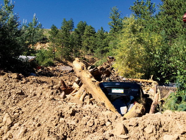
A car remained frozen in the rocks, timbers and other materials deposited by a deadly Jamestown debris flow. JoAnn Holloway
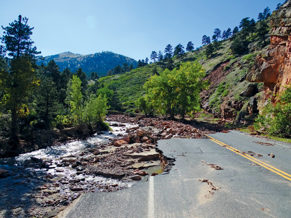
Inertia-enhanced erosion caused heavy damage to roads on the outside of river bends, even when the roads were 3 to 6 meters above the river channels. Geoff Plumlee, USGS
Around almost every bend in the road on our tour of the Colorado Front Range and points downstream in the weeks after the September floods, the physical devastation confronted us like a punch in the gut. Even though we had all seen graphic images on the news, observing the destruction firsthand, especially from a geologic perspective, was truly stunning and humbling.
My colleagues and I were part of a multidisciplinary U.S. Geological Survey (USGS) response to the floods. Our research group at USGS in Denver has assessed the environmental and related health implications of hazardous materials produced by many past disasters, such as the airborne dusts kicked up when the World Trade Center towers collapsed, Hurricane Katrina flood sediments, wildfire ash and debris, and volcanic ash. We also apply lessons learned from these responses to anticipate potential environmental and health issues that might result from future disasters. When disasters are looming, we immediately start thinking about how we can help if needed.
Not surprisingly, the same was true when the heavy rains and subsequent floods happened in our own backyard.
This is a firsthand account of what we observed: the power of nature and the impressive resilience of the people affected.
Sept. 12: As news reports started to reveal the magnitude of the flooding and destruction, I began compiling information on possible sources of contamination that might have been affected. Compared to other floods, the environmental impacts of which have been well studied, this event was shaping up as unusual based on the wide range of both natural materials and anthropogenic contaminants that could potentially be transported by the floodwaters from many different sources.
Sept. 13: Others at USGS were also already responding. JoAnn Holloway, a member of our group, sent me videos of the active flooding in her Boulder neighborhood. Sheila Murphy and other researchers in Boulder were making plans to start sampling Boulder Creek floodwaters and flood sediments.
Sept. 14: Jonathan Godt and colleagues from the USGS Geologic Hazards Science Center in Golden mobilized to assess the large number of debris flows and landslides in the foothills, which had been triggered by the rainfall and were contributing sediments to the floodwaters. Another USGS team from the Colorado Water Science Center quickly mobilized to replace stream gages that had been damaged by the flooding.
Sept. 16: Our group got a green light from management to sample and analyze mud deposits left behind after the floodwaters receded for potential environmental contamination.
Sept. 17: Gregg Swayze (a field veteran from the USGS responses to the World Trade Center attack, Hurricane Katrina, the Gulf oil spill, and various wildfires), volunteer Kris Mitchell and I headed out to Sterling, Colo., a day after the peak flow had passed, and began working our way back upstream.
Over much of the next two weeks, Gregg and I, with the help of many USGS colleagues, collected samples of flood mud and sediment deposits from more than 60 sites across the South Platte Basin. We took many photos during our sampling efforts, which can be combined with pre-event satellite imagery and Google Street View images (the latter an inspired idea by Jamie Holmes of Stratus Consulting) to illustrate many flood processes and impacts. I write this article with grateful acknowledgement of the observations made and photographs taken by many of my colleagues.
The volume of floodwater in the system and the time it took for it to flow through the basin were impressive. On Sept. 17, a day or two after the peak flow had passed along the South Platte between Greeley and Sterling, the floodwaters were still almost a kilometer wide in places. A day later, streets were still flooded with knee-deep water in Evans, near the confluence of the South Platte with the St. Vrain River, even though almost a week had passed since the heaviest rains. Flood debris caught on 2-meter-tall fences remained, and mobile homes rested away from where they had been before the floods, transported not by trucks but by floodwaters.
When sampling in downtown Longmont on Sept. 19, we could see from the debris caught in trees that, during peak flooding, the waters had filled the more than 60-meter-wide St. Vrain River channel to a depth of 3 meters in places, and had spilled another 15 meters laterally out of the main channel to flood nearby buildings. By Sept. 26, more than two weeks after the peak flooding, floodwaters were still flowing through pastures well outside Boulder Creek’s main channel near its confluence with the St. Vrain.
In the urban areas of Boulder and Aurora, storm drain systems had quickly become overwhelmed, which led to the flooding of homes beyond FEMA’s mapped floodplains.
On our sampling sojourns, it quickly became apparent that the flood event had caused the erosion, transport and redistribution of huge volumes of rocks, sediments and soils. Debris flows and landslides contributed substantially to the damage in the foothills, and to the sediment loads carried by the floodwaters. We saw sobering evidence of this while sampling James Creek above and below the historic mining town of Jamestown: The residents had erected a makeshift memorial to their long-time neighbor who was killed when a debris flow hit his house.
River channels were scoured to bedrock in the foothills, whereas in many other places, we saw extensive sediment deposition, the sediments ranging in size from silt to half-meter-diameter boulders. People recounted hearing the boulders clunking in the rivers, even over the din of the roaring waters. In general, the maximum size of the deposited sediments decreased to sands and small gravels in the downstream reaches of the South Platte, but even there we saw the occasional small boulder that had been relocated.
The runoff, flooding and erosion were highly dynamic, with the sediments and river channels recording many different changes in energy and course. Some of these changes were likely due to variations in the rainfall and runoff rates over the course of the storms. However, the foothills residents we encountered described another cause: Vegetation and debris periodically collected at choke points and impeded the flow of the rivers. When these temporary dams failed, devastating surges of floodwater and debris crashed downstream. We saw evidence of these pulsed floods recorded by interbedded coarse and fine sediment deposits.
The floodwaters were often most damaging in places where inertia dictated they go straight but humans or the pre-flood river channel had tried to divert them. For example, significant erosion and overbank flooding occurred on the outside bends of meanders in the preexisting river channels. In many areas, we saw where sediment or debris deposition had forced the rivers to change course to entirely new channels. In some cases, we saw where sediments deposited in one part of the streambed had subsequently been partially eroded by later floodwater pulses following different pathways — evidence that the river channels had changed course multiple times during the floods.
From the foothills to the plains, the South Platte River Basin is unusual, though not unique, given the substantial variability in the potential sources and types of contamination that could be released as a result of flooding and damage. Among others, these include: naturally mineralized rocks, soils and sediments; potentially lead- and uranium-bearing mine wastes and tailings from foothill mining areas (for example, the historical tailings impoundment at Jamestown was partially breached); debris from damaged houses and highways; septic systems from rural residences; untreated or partially treated sewage from flooded or damaged wastewater treatment plants in Lyons, Boulder and other towns and cities; and possible releases of agricultural chemicals and animal wastes from agricultural and animal feeding operations along the South Platte in northeastern Colorado. An additional concern expressed by the public was whether contamination had been caused by releases of oil and produced waters from some flooded oil and gas production wells.
In October, the Colorado Department of Public Health and Environment (CDPHE) released preliminary results of its water quality sampling, carried out after the peak flood surge had passed. Results indicated that levels of metals as well as volatile and semi-volatile organic contaminants in the post-peak floodwaters were below levels of concern for drinking water and agricultural water, and that the majority of pollutants analyzed were below the state’s acute standard levels for protection of fish and aquatic insects. This may have been a result of dilution caused by the extreme volumes of floodwater.
CDPHE did find elevated levels of E. coli, a common pathogen found in sewage and animal wastes, in some locations. CDPHE also noted that some aquatic water quality standards might have been exceeded during the course of the flood event, and that further testing would be needed to determine if groundwater quality in alluvial wells along the Platte River system was affected.
We focused our sampling primarily on the muds because they tend to be the fraction of flood sediments that is most contaminated. Mud is also the most readily taken up by aquatic and terrestrial organisms, including humans via accidental ingestion (for example, by hand-to-mouth contact) or by inhalation of dusts generated from dried sediment deposits. Sampling the mud will also give us some idea of potential contaminant transport in the suspended sediments during the peak-flow conditions when water sampling was impossible.
Altogether, we collected at least three mud samples each at 63 different sites around the region, and we are conducting a wide range of analyses on these samples. These include testing for bulk inorganic and organic chemical composition; mineralogy by X-ray diffraction; particle size, shape and composition by scanning electron microscopy; the presence or absence of specific pathogens; and other geochemical methods that bear on human health. We expect to have many of the results back from our analyses by the time this article is published.
It is possible that the sheer volumes of rock, soils and sediments transported by the floodwaters diluted many contaminants in the muds to below levels of potential concern. For example, we were surprised by the rapid drop-off in amounts of obvious debris from destroyed buildings in the mud and coarser sediments as we sampled downstream from towns such as Jamestown and Lyons. Where did components such as copper pipes, wiring and electronics go? Are they buried within rocky materials? Or, were they pulverized into pieces not readily visible with the naked eye? Hopefully, microscopic analysis will tell us. We do expect to find evidence of pulverized asphalt in many of the samples, particularly in those collected from river stretches where extensive road damage occurred.
Impacts of the copious amount of debris on the environment remain to be seen. Most debris appeared to be natural vegetation, but there were also a lot of anthropogenic materials such as cut wood, some septic or liquid petroleum gas tanks, paint cans, tires, and (sadly) plastic toys. Some tanks may leak, chemicals from pressure-treated woods may leach into the waters, and debris piles may simply serve as new homes for undesirable rodents and insects. Further work is also needed to assess the ecological impacts of the flooding, such as the physical destruction of aquatic and riparian habitat, as well as potential impacts of contaminants carried by the floodwaters.
As with all of our previous disaster responses, our quest to collect scientific data to assist in the response after the Colorado flooding had to be tempered continually by sensitivity to the substantial human physical and emotional tolls inflicted by the disaster. Lending an empathetic ear and describing what we were observing to local residents we encountered were often the most immediate forms of assistance we could provide. It was frustrating to not be able to help in more tangible ways given the time pressures we were under to complete the sampling. But there were small gestures we could make. I admired Gregg Swayze’s ability to engage local residents in conversation, for example. And I was proud that Gregg and Zach Perlman tried to help a woman in Evans rescue her cats that had been stranded by the floodwaters, and that Gregg gave his spare dust mask to a Jamestown resident who had been cleaning up her flooded house without one.
For me, a lasting memory will be the too-brief discussion that Bill Benzel and I had with a resident of Lyons who pulled up next to us in his car as we were waiting for access past road reconstruction. He told us that his house had been destroyed by the flooding, and that his daughter had found the most intense flooding far scarier than her experiences in Japan during the Tohoku earthquake and tsunami. I wanted to hear more, but the road opened and he drove away.
The resilience of the residents was apparent wherever we went. Many had obviously wasted no time rolling up their sleeves and getting to work cleaning up. Their uniformly matter-of-fact attitude about what had happened and what needed to be done to clean up, rebuild and go on impressed us repeatedly, as did the humor they showed in the face of adversity — their stories were often recounted with a smile and a joke.
Residents of area towns affected by the flooding asked us more than once if geologists are going to help public officials decide whether to restore the river channels to natural or more controlled courses. It is clear that the involvement of experts on landslides, debris flows, sediment transport, fluvial geomorphology, geological engineering and other disciplines will be key for a successful recovery.
This earth science input is needed to understand why and how the rivers responded the way they did during the flooding; to help decide how to restore or reroute the river channels; how best (or whether) to rebuild floodplain houses, other structures and roads lost in the flooding; and how damage to the built and natural environments can best be mitigated in future floods.
Results of the mud-characterization and water-quality studies being carried out by the USGS and the state of Colorado will help us understand whether or not the wide range of contaminants that potentially were released from diverse mountain, urban and plains sources pose short- or long-term risks to the environment and health. Lessons learned from these environmental studies can also be applied more broadly to help assess, prioritize and mitigate the potential for environmental contamination produced by future extreme flood events, both in Colorado and elsewhere.
© 2008-2021. All rights reserved. Any copying, redistribution or retransmission of any of the contents of this service without the expressed written permission of the American Geosciences Institute is expressly prohibited. Click here for all copyright requests.