
by Sara E. Pratt Monday, December 14, 2015
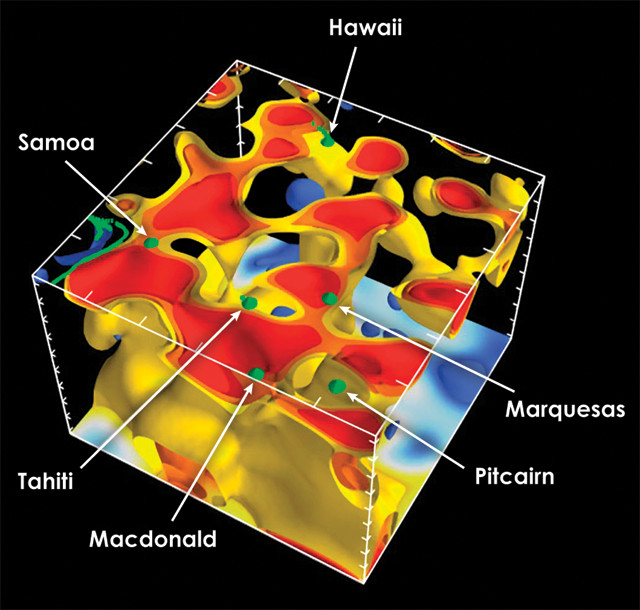
Scientists using a new tomographic model of Earth's mantle have identified 5,000-kilometer-wide swells of potentially hot material in the lower mantle that the researchers say confirm the existence of plumes. Credit: French and Romanowicz, Nature, 2015.
Technological advances continue to improve the resolution of our view of Earth’s interior, but disagreement remains over what we’re viewing. In a recent Nature paper titled, “Broad plumes rooted at the base of the Earth’s mantle beneath major hot spots,” Scott French, a computational scientist at the Department of Energy’s National Energy Research Scientific Computing Center at Lawrence Berkeley National Laboratory, and Barbara Romanowicz, a seismologist at the University of California at Berkeley, reported the development of the most detailed model yet of the structure of the mantle.
The three-dimensional tomographic model, similar to a medical CT scan, revealed large swells of what is likely hot mantle material with diameters roughly 1,000 kilometers wide. The structures, dubbed plumes by the researchers, rise from areas at the core-mantle boundary with strongly reduced seismic velocities, which are embedded in larger zones with anomalously low velocities that are up to 5,000 kilometers wide.
“Previous tomographic models have hinted at the existence of plumes, but it was hard to say unequivocally that they were there,” French says. “With our model you can say ‘Yes, that definitely is a plume.'”
In the model, plumes were identified under Hawaii and Iceland but not beneath Yellowstone. A few of the structures seen in the model rise into the upper mantle — beneath Pitcairn Island, for example — but most do not get above depths of 1,000 kilometers.
“They start to thin out in the upper part of the mantle, and they meander and deflect,” Romanowicz said in a statement released with the new study. “So while the tops of the plumes are associated with hot spot volcanoes, [the larger plume bases] are not always vertically under [the hot spots].”
French says the remnants of the plumes in the upper mantle “would be too narrow for us to see, even with the techniques we use, which are limited in local resolution due to the fact that we are imaging the whole mantle.”
This new view of the structure of Earth’s mantle arose from a model that French and Romanowicz developed using wave-form inversion — which, like typical seismic tomography, is based on a technique similar to the statistical regression used to best fit data points to a line or curve. But their model differs in how it makes use of seismic data.
“The difference between what we do and what most other researchers do,” French says, “is that instead of using the arrival times of specific seismic waves as our data, we use the entire seismic waveform record.”
The researchers used 3 million hours of supercomputer time (with many processors running in parallel) to hone their model of the fast and slow regions, which are interpreted as warm and cool areas, of the mantle until the model was able to accurately simulate seismogram outputs that matched the real-world results from 273 strong earthquakes that occurred over the past 20 years.
Previous tomographic models faced computing limitations that required simplification of the physics to the point that information was lost, French says. “Supercomputing allows us to treat the physics more exactly so we can get around these traditional impediments.”
But whether the plumes actually represent temperature differences and show convection remains unknown. The standard seismological view is that low shear-wave velocities indicate hotter material, French says, but they can also be caused by compositional differences, which would also explain the plumes’ vast widths and long-term stability.
The new study emphasizes the role of language in the plume debate, which is no stranger to semantic arguments. As early as 1973, just a few years after W. Jason Morgan first suggested mantle plumes, one researcher sought clarification on how plumes differed substantially from the normal convective models already suggested by plate tectonics, writing: “It would be most helpful if someone would explain in terms that are meaningful to geophysicists in what respects the conventional geological pictures of rising magma differ from ‘a thermal plume.'”
While what French and Romanowicz have found may not sound like a traditional plume, French says the structures they identify may be related to large low-shear-velocity provinces, also called superplumes. “Those [low-velocity zones] are in close juxtaposition to where we see these plumes,” he says, “but the plumes are anchored near the edges of those zones.”
New models like French and Romanowicz’s might help researchers begin to reconcile what we see on Earth’s surface with what we can know of its interior. And, in the future, perhaps further technological advances will help change the language of the debate itself.
© 2008-2021. All rights reserved. Any copying, redistribution or retransmission of any of the contents of this service without the expressed written permission of the American Geosciences Institute is expressly prohibited. Click here for all copyright requests.