
by Mary Caperton Morton Friday, March 24, 2017
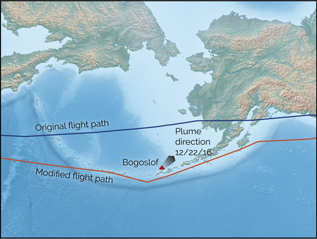
On January 11, 2017, a flight from Tokyo to Minneapolis was rerouted southward due to low-level ash emissions from Bogoslof Volcano in the Aleutian Islands. Although no significant eruption occurred, the plane continued along the modified flight path rather than risk rerouting midflight in the event of increased volcanic activity. Credit: K. Cantner, AGI.
One of the next-generation tactics being pursued by engineers is the use of ash-sensing equipment installed on airplanes that could warn of an ash cloud ahead and allow pilots time to adjust their flight path to avoid the cloud. “If you’re driving a car and you see a hazard up ahead, you can navigate around it,” says Fred Prata of the University of Oxford in England. “Every aircraft has radar equipment with which [pilots] can see weather systems and fly around them. This is the same concept, but adapted to image volcanic ash.”
Such sensors would be able to detect ash between 50 and 100 kilometers ahead of the aircraft, giving pilots about six to 10 minutes to adjust their flight path. Not every plane would need a sensor, Prata says. “One plane can identify the hazard and relay that info to other planes and air-traffic controllers.” Such instruments have been tested on the ground and on airplanes, but the extreme conditions of flight are proving difficult for the sensitive instruments. “Once you get up high, everything is much colder,” Prata says. “These instruments are very sensitive. They work nicely at 30 degrees Celsius, but once you take them up to minus 30, things get tricky.”
The concept is interesting, says Marianne Guffanti of the U.S. Geological Survey, and may help in those rare cases where planes fly near a remote ash cloud that hasn’t already been detected. But, she says, it’s unlikely to work fleetwide in busy airspaces. “We can’t have a bunch of planes changing course midflight on short notice. It would be chaos,” she says. “There will always be a need for a larger strategic approach for detecting eruptions and tracking ash clouds to avoid putting planes on a collision course with an ash cloud.”
© 2008-2021. All rights reserved. Any copying, redistribution or retransmission of any of the contents of this service without the expressed written permission of the American Geosciences Institute is expressly prohibited. Click here for all copyright requests.