
by Scott Burns Monday, May 5, 2014
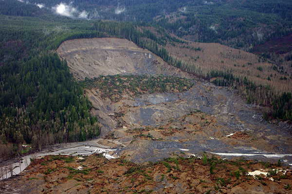
Aerial photograph of the upper parts of the Oso landslide that occurred in northwest Washington on March 22, 2014. Credit: Jonathan Godt, USGS.
Prior to March 2014, the Steelhead Drive neighborhood in Arlington, Wash. — on the banks of the north fork of the Stillaguamish River about an hour northwest of Seattle — comprised 45 houses, 25 of which were occupied year-round. Then, just before 11 a.m. on Saturday, March 22, the hill across the Stillaguamish River came tumbling down. More than 7.5 million cubic meters of debris, travelling at velocities up to 100 kilometers per hour, engulfed the community. In minutes, all 45 houses on Steelhead Drive were destroyed, along with nearly half a kilometer of highway SR530. At the time of this writing, 41 people had been declared dead and two were still missing, making the Oso landslide one of the deadliest in American history.
The landslide caused more than $10 million in property damage, which was not covered by insurance. And, so far, more than $32 million has been spent on recovery and rescue operations. Since the slide, geologists have been onsite — using an array of extensometers, survey points and reflectors monitored from an “engineering overlook” — to watch the slope across the river for signs that another slide might come down on rescue workers.
The recent event was not a surprise to geologists studying the area. Past landslides had been noted on the same slope historically in 1949, 1951, 1967, 1988 and 2006. And geologists looking at lidar images (laser imaging that produces an unobstructed view of the topography) of the region have seen many similar examples of mass wasting in the highly landslide-prone parent material up and down the Stillaguamish Valley.
But how did this slide happen?
The Oso landslide was a reactivation of an ancient landslide with additional sediment thrown in. The slope that failed was only 180 meters high, which is not huge by Pacific Northwest standards. It was steep, though, and made up of weak glacial sediments of primarily till and outwash deposited by retreating glaciers during the last ice age. A possible dense layer of silt and clay at the bottom of the stratigraphy would have allowed water to accumulate in the glacial sediment above. In March, the region experienced record rains — receiving almost twice the normal precipitation for the month. Ultimately, the combination of a steep slope, weak soils, abundant precipitation and a stream undercutting the slope at the bottom likely caused the landslide.
USGS geologist Richard Iverson has called the Oso landslide a “debris avalanche.” He calculated velocities of the slide as it hit the river of about 100 kilometers per hour. The size, velocity and magnitude of this slide surprised geologists. Future studies and resulting models will explain why the landslide mass liquefied so rapidly as it crossed the valley. The landslide mass crossing a flooding river, plus the descending landslide sediments liquefying during their descent, must have had something to do with this. Rescue workers were constantly hindered by the “quicksand” character of the slide debris.
Although geologists knew about the landslide potential of this area, that knowledge was not communicated — at least not well enough — to the people living there. Hopefully, the Oso disaster will make local communities more aware of the need to use landslide potential maps in their land-use planning and in issuing building permits to inform local residents of dangers.
While it has taken us years to develop flood and earthquake hazard maps for local communities, maps for lesser-known geological hazards, like landslides, have lagged behind. The technology for making excellent landslide susceptibility maps is now available because of advances in lidar and GIS technology, but few communities have these maps. They cost a lot for cash-strapped counties and cities to produce. Snohomish County is a typical, small county with minimal staff for land-use planning. An elementary landslide hazard map was produced for Snohomish County in 2010 by Tetra Tech, but that was after many building permits had already been issued for Steelhead Drive.
The landslide will also likely raise awareness of the need for landslide insurance. Typical homeowner’s insurance policies do not cover landslides. A homeowner can get some form of landslide insurance if they really work at it, but this extended coverage almost always comes from Lloyds of London and is very expensive. Eighty years ago, flood insurance or earthquake insurance weren’t options either, but today a homeowner can purchase it because the insurance companies gathered enough data on those two geological hazards to better understand and commoditize them. We have a long way to go to do the same for landslides. Another alternative is to have “all hazard” insurance, as they do in New Zealand, which covers earthquakes, floods, landslides, volcanoes, tsunamis, hurricanes, fires and tornadoes.
In order to avoid such large losses of life and property in the future, we need better prevention systems in place through improved land-use planning. And we need proper insurance coverage to reduce financial losses for when these hazards do occur.
The landslide has already had an effect on awareness. On April 9, 2014, in Jackson Hole, Wyo., an ancient landslide on a slope with homes and businesses reactivated (breaking pipes at a pumping station). Fearing the potential of another Oso landslide, the city evacuated more than 60 residents of the Budge Drive neighborhood, which included 45 homes, so geologists and engineers could investigate.
In reality, landslides pose risks wherever slopes are found. Hopefully, we will see similar acts of caution in the future.
To view a computer simulation of the Oso landslide constructed by David George and Richard Iverson at the USGS, go to: www.youtube.com/watch?v=2NzHCOhKr7g&feature=youtu.be.
© 2008-2021. All rights reserved. Any copying, redistribution or retransmission of any of the contents of this service without the expressed written permission of the American Geosciences Institute is expressly prohibited. Click here for all copyright requests.