
by Jennifer Strauss Thursday, September 3, 2015
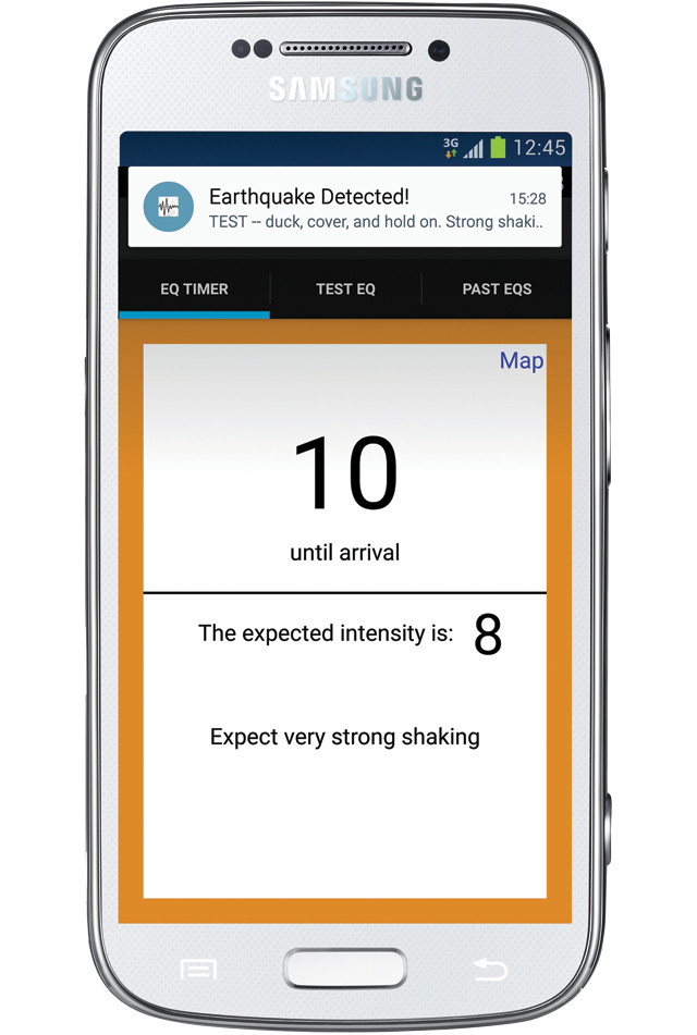
A mock-up of an earthquake early warning (EEW) alert on a cellphone. An EEW system is under development but not yet available to the public. Credit: K. Cantner, AGI, after Jennifer Strauss.
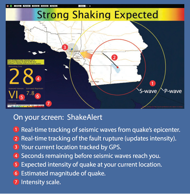
A ShakeAlert message like this would alert users to how many seconds they have before shaking waves arrive at their location and to the expected intensity of shaking. A shaking intensity of VI, as shown here, would mean the shaking would be strongly felt, people would find it difficult to stand, and structures could suffer damage. The warning message also displays a map with the location of the epicenter, the magnitude of the quake, and the current position of the P and S waves. Credit: USGS.
It is a cool foggy morning in San Mateo, Calif. A small ray of light has just peeked through my window. I listen to the birds chirping as I relish the final moments before my alarm calls for the start of a new day. It’s 6:15 a.m. Fifteen more minutes of a sleeping child.
A wailing cellphone alert breaks my serenity: “Earthquake! Drop, cover and hold on! Strong shaking expected!” I grab my phone and run to my daughter’s room. The MyEEW app — an earthquake early warning app released by our research team at the Berkeley Seismological Laboratory — is glowing bright orange: shaking intensity eight. We have 10 seconds until the shaking begins. Luckily, we have practiced this drill countless times at home. Muscle memory is the only thing keeping me centered while my thoughts race. Shaking intensity eight. Our condo is secure, but old. My husband grabs our go-bag and meets my daughter and me under our sturdy kitchen table. We hold on. Three seconds left. Hey, at least our timing is getting better.
3 … 2 … 1 … Lurch. We rock and roll like waves on the ocean in the middle of a tempest, but our human and table defenses hold firm. Books fly off the shelves. Pictures drop from the wall. We hear so much noise — objects smashing, furniture walking about — and even though I know it is fantasy, my mind conjures an image of us falling into the giant maw of the Earth. The seconds seem like hours, the lights flicker and die. Then there is silence. Only now do I dare check the map on my phone: a magnitude-7 earthquake just struck on the Hayward Fault.
In the following hours we find that although there is substantial damage to infrastructure — broken water pipes, downed transformers, facades fallen from historic buildings — there is also expected damage that is somehow missing. There are no people trapped in elevators, no derailed trains. Hospitals report very few head injuries from falling objects. It will be weeks until people digest what exactly happened in the aftermath of this long-expected earthquake, but early warning will have played its part in reducing the danger.
Perhaps I should back up a little. Of course … none of this actually happened. These are just my musings on what could happen if the Science Application for Risk Reduction “HayWired” scenario (read more at http://geography.wr.usgs.gov/science/mhdp/haywired.html) actually took place. The HayWired project allows utilities and emergency preparedness groups in the San Francisco Bay Area to model the impacts of a large rupture along the Hayward Fault on our modern built environment. The last large earthquake to occur on this fault was in 1868, so it is only through simulations that we can address vulnerabilities in our modern urban infrastructure, in which there are multiple layers of interdependence among lifelines as well as a major reliance on the Internet.
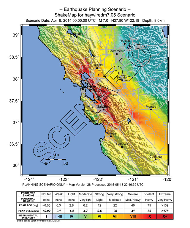
This ShakeMap shows the projected intensity of shaking across the San Francisco Bay Area if a magnitude-7 quake were to strike along the Hayward Fault. Credit: USGS.
Although a large rupture on the Hayward Fault has not happened in my lifetime, I do indeed have a prototype MyEEW app installed on my phone. And it does work. It roused me from my slumber at 3:24 a.m. on Aug. 24, 2014, during the South Napa quake, and we did drop, cover and hold on under our very sturdy table. It is true that, in that case, we would have been just as safe staying in bed, but I did not want to leave my 3-year-old in her room shaking all alone when we had several seconds’ warning to act. The app is not ready for public use yet, but we have made significant strides toward that end. The good news for people on the U.S. West Coast is that earthquake early warning (EEW) is making progress along the path from being a good idea to becoming reality — hopefully, it will be a reality before the next major earthquake.
EEW is not earthquake prediction. There is currently no system in existence that can say with good odds that an earthquake will happen at a certain epicenter, with a certain magnitude, at a precise time in the future — which is what prediction entails. EEW is exactly what it says: It is an early warning that shaking is coming. It can typically give a few seconds to a few minutes, at most, of early warning. EEW is the equivalent of seeing a funnel cloud start to form in the distance and giving people time to get into their storm cellars before the tornado overcomes them — except on a significantly shorter timescale.
The U.S. Geological Survey, the Berkeley Seismological Laboratory, the Caltech Seismological Laboratory, and the Pacific Northwest Seismic Network (PNSN) are working on a prototype EEW system called ShakeAlert. ShakeAlert leverages a portion of the pre-existing stations in the California Integrated Seismic Network (CISN) and PNSN to provide real-time information about earthquakes on the West Coast of the United States.
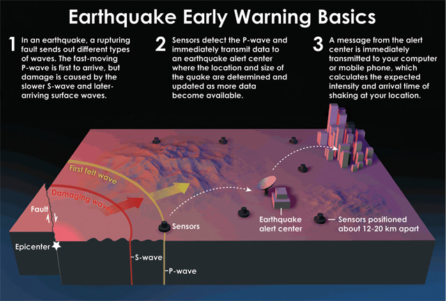
How an earthquake early warning system would operate. When an earthquake occurs, compressional (P) waves and transverse (S) waves radiate outward from the epicenter. The P waves, which travel fastest, trip previously installed sensors, causing alert signals to be sent ahead, giving people and automated electronic systems seconds to minutes before damage begins with the arrival of the slower but stronger S waves. Credit: USGS image created by Erin Burkett (USGS) and Jeff Goertzen (Orange County Register).
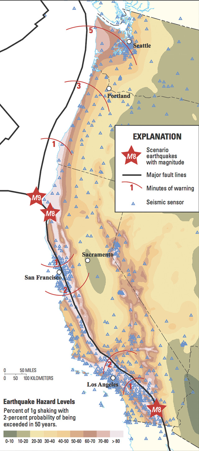
This illustration shows how much early warning residents along the West Coast could have if a magnitude-9 quake were to rupture northward on the Cascadia Fault or if a magnitude-8 quake were to rupture on the San Andreas Fault at the northern or southern ends. Credit: USGS.
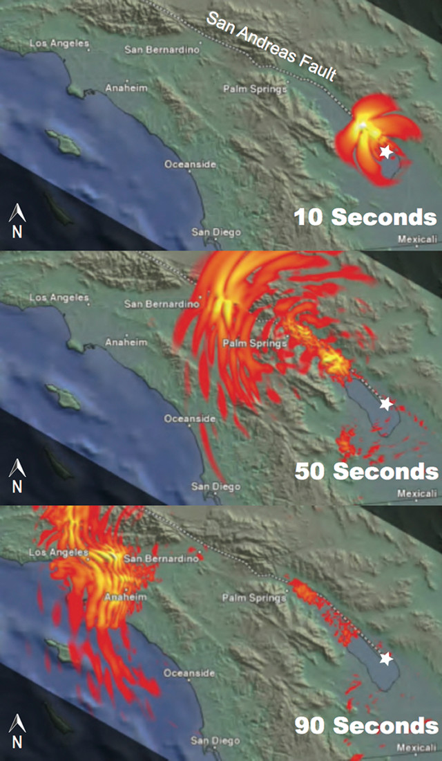
The diagram below shows how soon shaking would be felt in populated areas if a magnitude-8 quake struck the southern San Andreas Fault near the Salton Sea. Credit: USGS.
When an earthquake begins, the fast-moving primary compressional wave (P-wave) front is picked up by nearby CISN or PNSN sensors. Data from these sensors are monitored by the ShakeAlert system in real-time, which quickly assesses if a P-wave trigger is present, determines the characteristics of the earthquake (origin time, magnitude and epicenter), and sends an alert about the shaking intensity expected from the slower-moving secondary transverse wave (S-wave) front to devices away from the epicenter. The P-waves move about twice as quickly as the more destructive S-waves, but are usually not damaging. As the distance from the epicenter increases, the P-waves have more opportunity to out-run the S-waves, and thus the warning times given ahead of potentially damaging shaking are mainly a matter of how far you are away from the origin.
But simply generating an alert is not enough. Time is lost in transmitting alerts to consumer devices and emergency alert systems, which serve to actually transmit the alert to people and facilities that then need time to act on the alerts. So, speed is of the essence. The project is maturing technologically to improve the timing of early warning alerts. For example, our algorithms can now quickly assess P-waves and provide details about the impending shaking, sometimes before the S-wave even reaches the surface. This is especially critical in California, where much of the population resides directly on the faults we are informing them about.
We also continuously monitor system performance to catch oddities that should be addressed. Large earthquakes hundreds or thousands of kilometers away don’t cause heavy shaking locally, but the P- and S-waves of those ruptures are still picked up by the local sensors. The algorithms are calibrated to ensure that these large teleseismic events are not mischaracterized as smaller local events. The system must also be able to deal with stations going through their own calibration sequences, locating earthquakes on the edges of our network, and separating the individual P-wave triggers of foreshocks, aftershocks and mainshocks that could happen one right after the other (and thus have overlapping seismic signals).
New ideas and algorithm types are shared among the science teams to constantly push the envelope of what is possible. For example, we are starting to combine traditional seismic algorithms with new GPS technologies to monitor ruptures as they happen in real-time and to refine magnitude estimates for large quakes. Longer-term efforts include incorporating scientific understanding of past behavior on specific faults to better assess the hazards associated with particular alerts.
The production prototype team is building systems and computer infrastructures to ensure robust, reliable and redundant operation as well as to provide a mechanism to add new software or seismic stations seamlessly. New seismic stations and equipment still need to be installed in all areas of the state to increase monitoring capabilities. And fast, reliable communications need to be coordinated to both reduce costs and diversify telemetry. Despite the substantial degree of automation in an early warning system, round-the-clock staffing for some aspects of the system may also be required to make sure problems are addressed rapidly. A public system that millions of people rely upon for safety cannot afford to have any single points of failure.
Even though we have a lot left to do in terms of the technology and infrastructure, we are already far ahead of the policy side of things. A public safety initiative like this involves more than generating an alert and simply passing it on to people on the street. There is a vast landscape involving political, legal and educational issues that must first be successfully navigated. And that navigation relies on partnerships, with each of the various legislative, public safety and private entities — such as utilities, hospitals, schools and alert distributors (like the emergency alert systems on your phone) — working in concert to make it viable.
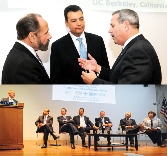
In September 2014, the University of California, Berkeley, hosted the 3rd International Conference on Earthquake Early Warning, a conference that included researchers, legislators and government officials from all over the world. Top: California State Sen. Jerry Hill, then-State Sen. Alex Padilla and California Office of Emergency Services Director Mark Ghilarducci. Bottom (left to right): Richard Allen (director of the Berkeley Seismological Lab), Sen. Hill, California Lt. Gov. Gavin Newsom, Sen.
One important partnership in the EEW effort was with Alex Padilla, the current California Secretary of State and an early political champion. Padilla was a state senator representing Northridge, the epicenter of Los Angeles’ last major quake, when he learned about ShakeAlert. In 2012, when then-Sen. Padilla was on campus at Caltech for an energy-related briefing, he was invited to stop by the Seismology Lab to learn about the ShakeAlert project and the frustrations associated with trying to bring the technology to the public. Padilla decided that if technology existed that could help save lives and reduce damage, public officials should be compelled to do something about it. So he did. In early 2013, he authored Senate Bill 135: Earthquake Early Warning System. The bill passed unanimously in both the Senate and Assembly and was signed into law in September 2013 by Gov. Jerry Brown. The bill, however, identified no funding source for making EEW a reality statewide.
The legislation tasks the California Office of Emergency Services (CalOES) with bringing EEW to California and with identifying potential funding sources, without using any “general fund” monies. CalOES soon afterward began to organize committees — populated by social scientists, seismic safety commissioners, private industry representatives, the USGS EEW coordinator, Berkeley and Caltech Seismology Lab scientists, and others — to provide findings and recommendations about what the system should look like, what standards it should meet, and how it will work. The committees presented the findings to CalOES Director Mark Ghilarducci in February 2015. CalOES is meeting with various sectors, including utility groups and telecommunications providers, to explore various funding options. The steering committee is scheduled to begin meeting this fall to put together an implementation plan and timeline based on the findings.
Part of the challenge ahead for CalOES and the unfunded mandate to bring EEW to the state of California is that, even if a funding source is identified, there is currently no mechanism in place to receive money for the system and redistribute it to network operators and public awareness programs. State Sen. Jerry Hill, who represents the South Bay Area region, is helping to address this. While the findings and recommendations were being presented by the committees to CalOES earlier this year, Sen. Hill authored Senate Bill 494: Emergency Services: Seismic Safety and Earthquake-Related Programs. The bill calls for the creation of the California Earthquake Safety Fund, which could accept and redistribute monies for the purpose of seismic safety and earthquake-related programs, including EEW. Senate Bill 494 passed the Senate floor in May 2015 and then the Assembly Government Organization Committee in July. It is now re-referred to the Assembly Appropriations Committee, where it needs to be approved before it can be called for a vote on the Assembly floor.
CalOES, the scientists and the stakeholders press on as policy works to catch up with the technology. The USGS, CISN and PNSN must work in coordination with CalOES, supporting them as they wrangle the players necessary to bring the California EEW system to fruition, while at the same time expanding the ShakeAlert demonstration system along the entire West Coast into a fully functioning production prototype. This large undertaking to get the politics, policies and science of the whole project aligned is paving the path toward not just a California system, but a full West Coast system. After all, Oregon and Washington are also at high risk from large earthquakes.

Some businesses in (clockwise from left) Seattle, Portland, San Francisco (including the Bay Area Rapid Transit, or BART) and Los Angeles are beta testing earthquake early warning. If an earthquake were to propagate northward starting along the southern Cascadia Fault, Portland and Seattle would likely have minutes of warning. Depending on the location of a rupture along the San Andreas or Hayward faults, Los Angeles and San Francisco would have seconds to minutes of early warning. Credit: clockwise from top: Howard Ignatius, CC BY-NC-ND 2.0; Eric Prado, CC BY-NC 2.0; BART; Wilson Hui, CC BY 2.0; Todd Jones, CC BY 2.0
University of Oregon has also joined forces with ShakeAlert, adding their efforts to the expanding West Coast project. We are also now looking toward transitioning our current beta testers, who include private businesses and city and county agencies among others, from the demonstration system to the robust and redundant production prototype. The first phase to transition the computer systems, software management schema and Internet traffic protocols for the production prototype will be completed by the end of this year. In the meantime, we will continue providing limited rollouts of the beta platform to new testers. In California, for example, we’ve been working with the Bay Area Rapid Transit (BART) system, the City of San Francisco and the City of Los Angeles for a couple of years as beta testers of the ShakeAlert system. The Pacific Northwest has recently added beta testers of their own, including Boeing, Alaska Airlines and Intel.
A demonstration phase of the ShakeAlert project was primarily funded by the USGS and a one-time grant from the Gordon and Betty Moore Foundation. In Congress, California’s Sen. Dianne Feinstein and Reps. Adam Schiff and Ken Calvert, and Oregon’s Rep. Peter DeFazio championed efforts at the federal level to leverage this seed investment. Due to their efforts, the West Coast EEW project was allocated $5 million in the 2015 federal budget. This allocation provides significant support for the project as a whole, and just enough capital to keep the investment viable and expandable into a limited rollout. But the allocation does not reach far enough to cover all of the geographic areas lacking a dense network of seismic instrumentation, telemetry and staffing to support the expanded network capacity. (The full increase in infrastructure would require a one-time investment of $38 million for the entire U.S. West Coast, as outlined in the USGS implementation plan for the ShakeAlert project.) The allocation does not go far enough to cover the estimated $16 million per year in additional operations needed to keep a full system running.
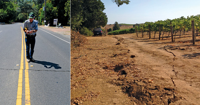
When the South Napa quake struck in August 2014, damage was minimal and deaths were few. Several buildings, homes and roads were damaged, and several vineyards lost wine as bottles and barrels crashed down. Visible fault scarps remain in the vineyards. The next time such a quake hits, the earthquake early warning network may provide enough warning to, for example, get someone into a protective cage at the end of a long row of stacked wine barrels. Credit: above: David Schwartz, USGS; right: Dan Ponti, USGS.
It does go far enough to jump-start the EEW system in areas where station density is already adequate, such as the Bay Area and the Los Angeles Basin. The federal investment allows the project to continue forward, giving the states a bit more time to determine how to financially support the system in the long term. It also gives first responders and key groups focused on resilience in these areas confidence that an early warning system is not a matter of if, but when. They would be able to begin their own budgeting and policy considerations for the implementation of automatic controls that can protect citizens and infrastructure from a damaging earthquake: For example, firehouse bay doors can automatically open to prevent trucks from getting stuck inside; transportation systems can automatically slow and stop trains to reduce the risk of derailment; and elevator doors could automatically open to prevent stranding people inside. Thus, even a limited rollout can have a huge impact, even if everyone does not personally receive the warning right away.
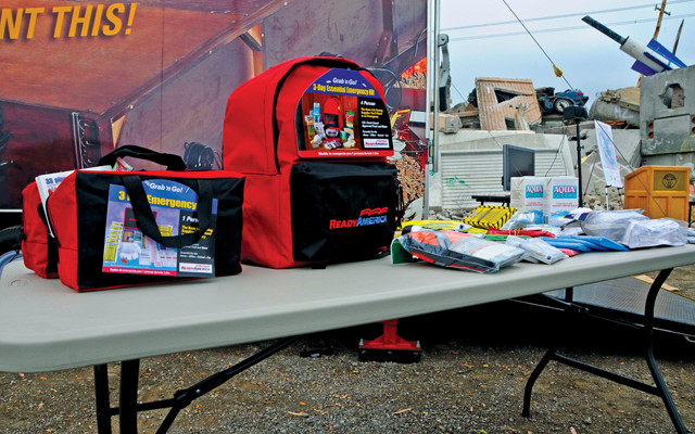
An earthquake early warning system is one part of overall resilience. People living in earthquake-prone areas should also be personally prepared, such as by having emergency kits at the ready. Credit: Brad Alexander, CalOES
The Napa earthquake taught us something critical about resilience. I received about 10 seconds of warning on my phone that morning, giving me peace of mind that I had a brief, but adequate, window in which to act. BART’s early warning mitigation protocol received an eight-second warning and started the decision process to determine whether to slow or stop the trains; no trains were running that early so it wasn’t an issue, but we could see that the system worked.
The people in Napa and American Canyon, who were jolted awake by the quake, did not have the same peace of mind. Many first responders in those locations told us during debriefings after the quake that they’d first thought that the quake had happened in San Francisco and that, “We must be on our own.” It wasn’t until Emergency Operations Centers were spun up and started contacting outside areas for damage assessments that they realized that the earthquake was local and that people were coming to help them.
Right atop the hypocenter of an earthquake, a warning might not come early enough. With shallow strike-slip faults in the San Francisco Bay Area, like the San Andreas or Hayward faults, the P-waves don’t have much time to outrun the S-waves before they reach the surface and the nearest seismic stations. Sometimes, the hypocenter is deep enough and a warning can be issued before the S-waves reach the surface. This is more likely in areas of dense station networks, which is why increasing coverage along the West Coast is so important. Seattle and Portland would likely have minutes to prepare if a magnitude-9 earthquake started at the southern tip of the Cascadia Subduction Zone and ruptured northward. Warnings are initiated at the epicenter of a quake, so the farther away you are, the more warning time you will have.
The shaking that you feel depends on how far away you are from the rupturing fault; closer locations will experience more shaking. This phenomenon is most evident for large earthquakes, such as the expected magnitude-9 Cascadia or magnitude-7.8 Salton Sea events. Locations far away from the epicenter would receive the most warning times, while still experiencing heavy shaking as the fault ruptures toward them. Whether just as the shaking begins or minutes before, any bit of warning can have important impacts on the ability of people and cities to recover.
With infrastructure upgrades, including station upgrades in the Bay Area made possible by the 2015 federal budget allocation, the northern part of Napa could receive a warning a very short time before shaking started if a repeat of the August 2014 Napa earthquake were to happen — probably long enough to stop an elevator at the nearest floor, and possibly enough to get someone into a protective cage at the end of a long row of stacked wine barrels. For certain, emergency response groups would have enough time to know what had just happened, and where and how bad damage might be before all power and communications are compromised.
As our project moves forward this year from a research demonstration system to a production prototype, we will start adding more seismometers to fill in gaps along the West Coast, where seismic monitoring has historically been sparse, in order to protect exposed populations. We will look to our partners to help draft a public education campaign, so that people will know what to do when an earthquake strikes. A good campaign seeks to not only inform and educate, but to instill the muscle memory that we as a species rely on when faced with dangerous situations. We also seek collaboration with more private companies, more groups and more municipalities, not only to beta test the system, but also to help champion its use and implementation.
Our hope is that one day, all people in earthquake-prone areas of the United States will have more tools to protect themselves and their loved ones as best they can. Structural retrofits of homes, schools and businesses are one tool. Another is education — people need to know to drop, cover and hold on wherever they happen to be or whatever their physical abilities allow them to do. Likewise, we advocate that households should have their own emergency kits to get them through the critical first 72 hours after any disaster — whether an earthquake or something else.
We see earthquake early warning as yet another tool among many in the resilience kit, but it’s a vital one that could save many lives.
© 2008-2021. All rights reserved. Any copying, redistribution or retransmission of any of the contents of this service without the expressed written permission of the American Geosciences Institute is expressly prohibited. Click here for all copyright requests.