
by Timothy Oleson Thursday, August 28, 2014
China is a thirsty nation. Rapid economic growth and urbanization among its nearly 1.4 billion people in recent decades, as well as a growing taste for meat, have created an ever-growing demand for freshwater. And in the cities, industrial centers and farmlands of the more populous, more arid north, available resources — rivers, lakes and aquifers — are drying up.
To cope, the Chinese government has undertaken ambitious projects to collect and reroute surface waters to areas of need. Two recently completed legs of the massive South-North Water Transfer Project — a system of canals and pipelines initiated in 2002 — are set to begin diverting roughly 28 billion cubic meters of water annually from the Han and Yangtze rivers north to Beijing, Tianjin and elsewhere amid the farmlands of the North China Plain. (A third route that would carry an additional 17 billion cubic meters annually is still being evaluated.)
Since about 2000, China has also relied increasingly on imports of water from abroad to help sustain its growth. This water does not arrive sloshing about in tanks aboard rail cars or ocean-going ships, but rather as “virtual water,” embodied in bushel upon bushel of dry soybeans mostly.
China is the world’s top soybean buyer, importing tens of millions of metric tons per year. And behind each ton is more than 2,000 cubic meters of water — either rainfall or irrigation — needed to grow, harvest and prepare soybeans for use. In the case of soybeans and other crops, the majority of this water is lost to the atmosphere through evaporation and transpiration during the plants’ lifetime, and none of it — save the tiny amount still hydrating the final product — actually makes it to China. Yet, to an extent, this virtual water represents an enormous volume of real water that China need not pull from its own shrinking endowment.
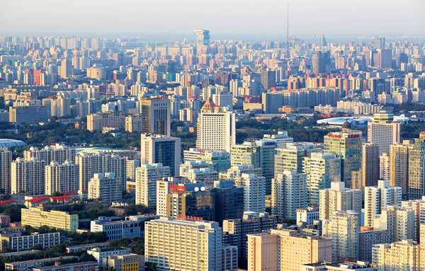
Rapid economic growth and urbanization in China have created an ever-growing demand for freshwater, particularly in cities like Beijing in the more arid north of the country. Credit: ©Shutterstock.com/testing.
The virtual water concept applies not just to crops, but to fodder-fed livestock, manufactured items, energy and any goods or services — agricultural, industrial or otherwise — that consume freshwater during their production. It’s a notion that, beginning in the mid-1990s, quickly took root across a range of disciplines, and has since expanded and evolved. Virtual water volumes, for example, are used to calculate water footprints — estimates of direct and indirect water use by producers and consumers — which have been used as an outreach tool to raise awareness of sustainability concerns. And both virtual water analyses and water footprints have been cited by many as potentially valuable tools for influencing trade and water policies to promote conservation and combat water scarcity.
But along with the ideas’ promotion have come resistance and criticism. Many researchers stress a cautious approach, suggesting that virtual water is a useful, albeit limited tool for addressing water issues. Others contend that calculations of virtual water are inconsistent or inaccurate, that volumetric indicators ignore important local socioeconomic factors related to water consumption, and that, if used to guide trade or water allocation policies, they could end up hurting the very populations at risk from water scarcity.
Regardless of the debate, the concepts of virtual water and water footprints have migrated beyond academia, gaining footholds in the public and among a number of governments and multinational businesses. How this traction might shape approaches to water sustainability in the future is not clear. But given its prevalence, virtual water does not appear to be losing steam.
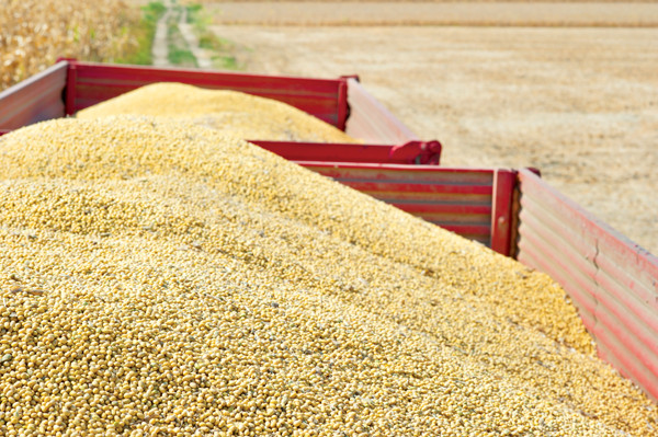
Although it also produces soybeans domestically, China is the world's leading importer, accounting for about 90 percent of the country's virtual water imports. Credit: ©Shutterstock.com/Fotokostic.
Drawing on earlier concepts of water volumes “embedded” in goods, Tony Allan, a political geographer and Middle East scholar at King’s College London, coined the term “virtual water” in 1993 to help explain why long-predicted “water wars” driven by water and food security had not occurred among the arid nations of the Middle East and North Africa. Allan noted that Egypt, Israel, Jordan and other countries in the region were buying millions of tons of grain each year from water-rich countries to supplement their own food production and buoy prosperity.
“Importing rice and wheat and all these water-intensive commodities is basically a replacement for having your own water” to grow them, says Jeff Reimer, an international trade economist at Oregon State University. The grain imports eased stress on the countries’ own limited resources — perhaps easing cross-border tensions in the process — and freed up internal water for other uses like industry and direct consumption.
And, of course, if virtual water could be imported, it could be exported — perhaps as manufactured goods or as higher-value foods — and traded as well. Political scientists, economists, engineers and others began using the concept to spotlight invisible patterns of virtual water trade that had arisen unwittingly in parallel with flows of commodities traded globally, regionally and locally.
Credit: Kathleen Cantner, AGI.
It may seem unconventional, but it is actually an old idea, Reimer says, “going back maybe 100 years to economists who viewed international trade in goods or commodities not just in those commodities themselves, but in the factors of production,” like labor and capital. Basically, you’re “breaking out water [from the capital component] as a distinct factor of production, and identifying it as implicitly being traded when you’re importing something like rice.”
As researchers latched onto Allan’s point that virtual water trading could benefit water-scarce regions, some began suggesting its usefulness not only as a descriptive tool, but potentially as a prescriptive one that could mitigate human impacts — primarily overuse and pollution of surface and groundwater reserves — on water resources.
The idea caught on, in part, because it “was introduced around the same time that people were starting to think about things like carbon footprints and ecological footprints,” says Ben Ruddell, a civil engineer at Arizona State University. These notions implied that people’s behavior as consumers and producers could impact the natural world — be it the atmosphere, an ecosystem or a watershed — well beyond their immediate vicinity. Virtual water “really went along with this idea that we live in a connected world,” he says.
“When you look at the math, you realize that there are people who are very dependent on virtual water trade,” both as importers and as exporters, Ruddell says. And in the last 20 years, a multitude of analyses have studied these dependencies. Most have looked at virtual water tied up in the global trade of agricultural goods — estimated to account for about 80 percent of freshwater consumption worldwide — although an increasing number of efforts are narrowing the focus to smaller scales.
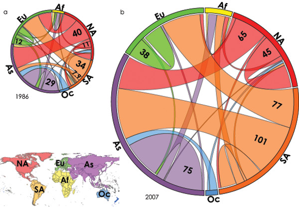
Total virtual water flows — considering trade of eight major food commodities — among regions of the world in 1986 and 2007. Band colors denote the virtual water exporting continent, and numbers indicate total volumes in cubic kilometers. The relative difference in size of the circles indicates the overall growth of the virtual water trade. Credit: ©Carole Dalin, Dalin et al. (2012) PNAS 109, 598.
In 2012, Carole Dalin, then a doctoral candidate at Princeton who is now at the London School of Economics, and colleagues described the flows of virtual water globally among countries and continents in a study published in Proceedings of the National Academy of Sciences. Specifically, they looked at trade involving eight agricultural staples — barley, corn, rice, wheat, soy, beef, pork and poultry — between 1986 and 2007.
The virtual water content of each commodity in each country was determined using a hydrologic model that combined meteorological data with tallies of the areas over which different crops and livestock were cultivated in each country to estimate water consumption per unit of the commodity. To quantify the virtual water flows between countries, they then multiplied this water consumption by the volumes of each commodity traded as documented by the U.N. Food and Agricultural Organization.
Based on their analysis, the researchers produced plots of how virtual water trade volumes related to different crops had changed over time, as well as intricate diagrams depicting the network of flows moving within and between each continent (excluding Antarctica). Among the trends they noted in the study were that: the total virtual water volume associated with global food trade had more than doubled during the 22-year study period, in part reflecting the overall growth of global trade; that “international food trade has led to enhanced savings in global water resources over time” by transferring commodities grown in countries that use water more efficiently — either because of more favorable climates or better technology — to less water-efficient countries; and that virtual water trade patterns had shifted substantially in some respects.
Notably, they found that virtual water trade within North America quadrupled — likely an outcome, at least partially, of the North American Free Trade Agreement enacted in 1994. Asia, meanwhile, increased its virtual water imports by 170 percent, with China leading the way.
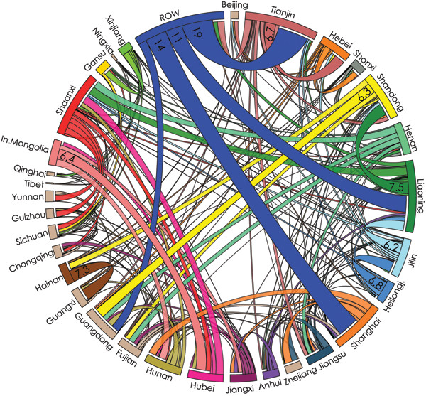
Total virtual water flows — considering trade of barley, corn, rice, wheat, soy, beef, pork and poultry — among China's provinces. "ROW" stands for "Rest of the World" and denotes virtual water imports in these commodities from outside the country. Numbers indicate total volumes in cubic kilometers. Credit: ©Carole Dalin, Dalin et al. (2014) PNAS 111, 9774.
“China is a particularly interesting example because of its importance in the world,” says Ignacio Rodriguez-Iturbe, a hydrologist at Princeton University and co-author of the study. In addition, China keeps detailed records of trade between its provinces, he says. “So one can establish these flows of virtual water not only between China and the rest of the world, but also between the internal provinces of China. And this is very important if one wishes to make policy regarding food and water and land.”
In 2001, China became the world’s largest virtual water importer, and, by 2007, accounted for 13 percent of the total global trade. Roughly 90 percent of this amount was due to imports of soybeans. China had begun lifting restrictions on soybean imports in 2000, resulting in large influxes, predominantly from Argentina, Brazil and the U.S.
“This is an example of how one policy decision had an impact worldwide in terms of the virtual water flows,” Rodriguez-Iturbe says. “In the United States, people started saying: ‘Soy trade with China is going to be very important, let’s start planting soy like crazy and forget about other things.'”
Despite the sizable imports of soy and other goods, and their associated virtual water, China by all accounts still faces tremendous water scarcity issues. Recognizing that these issues arise regionally and locally due to unequal distributions of water and arable land, Dalin, Rodriguez-Iturbe and their colleagues took a closer look at virtual water within China in another study published in Proceedings of the National Academy of Sciences earlier this year.
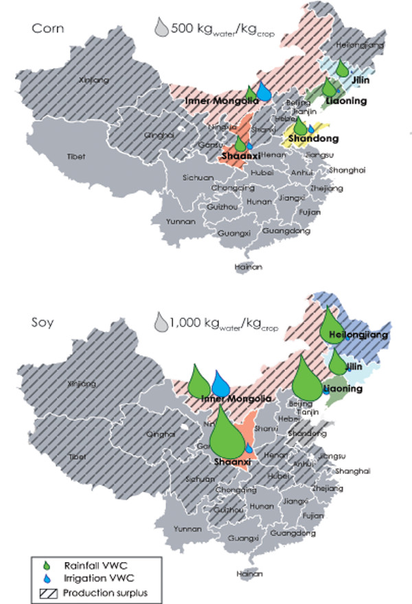
Maps of China illustrating the virtual water content (VWC) of corn (top) and soy (bottom) in the top five exporting provinces (in color) of each crop in 2005. The size of green and blue water drops is based on the amount of each type of water consumed and is scaled relative to the baseline water drop in each case. Cross-hatching denotes provinces where production of the crop is greater than consumption. Note the relatively large size of blue water use for corn and soy in Inner Mongolia. Credit: ©Carole Dalin, Dalin et al. (2014) PNAS 111, 9774.
They applied the same approach to studying flows tied to agricultural trade among 31 of the country’s provinces (the analysis did not include Hong Kong, Macau or Taiwan), this time breaking out water use for crop production based on whether it came from rainfall (known as “green water”) or irrigation using surface or groundwater (“blue water”). Conventionally, consumption of green water — essentially free to use in most cases, and much of which would be consumed by noncrop plants anyhow — is preferable over blue water, which depletes aquifers and impacts ecosystems if overused.
The researchers found that most provinces consume predominantly green water for agricultural production, but that volumes of green and blue water required to raise given crops or livestock vary widely across the country. Reflecting the dry climate in northern China during the growing season, for example, provinces like Ningxia, Xinjiang and Inner Mongolia — net exporters of commodities like soybeans and corn — use large amounts of blue water for irrigation.
Inner Mongolia, in particular, is one of the top exporters of corn, yet relies on irrigation for a far greater proportion of the water needed to grow it — more than 50 percent — than other corn-exporting provinces do. This “means that dry, irrigation-intensive provinces tend to export [virtual] water to less water-intensive” provinces, Rodriguez-Iturbe says, which, from a water-efficiency perspective, “doesn’t make a lot of sense.”
Currently, he says, his team is working with Chinese colleagues who are “providing the possible scenarios of policy” that could affect large-scale reorganizations of crop growth or subsidies to different provinces, for example. Many other factors — social, economic and environmental — come into play for countries making policy decisions, Rodriguez-Iturbe says, “but you want to be logical in your use of water and its links with food production.” And virtual water trade analyses will help officials make more rational policy decisions and better comprehend their impacts, he says.
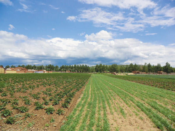
Crops growing in Wuchuan County, Inner Mongolia. Credit: ©Azylber, CC BY-SA 3.0.
China isn’t the only country facing concerns over water scarcity and sustainability. And in some countries, the premise of using virtual water and water footprints to understand and cope with these issues has been brought to the table not just among researchers, but within government.
In the late 2000s, Spain passed a regulation requiring that footprint analyses be included in water resource management plans for river basins. And in India, the 2012 National Water Policy from the Ministry of Water Resources called for using water footprints to “incentivize efficient use of water” and to assess effects of industrial projects on water resources.
Elsewhere, however, reports examining the usefulness of virtual water accounting as a policy tool have reached different conclusions. In a July 2008 statement, Australia’s National Water Commission concluded “that the measurement of virtual water has little practical value in decision-making regarding the best allocation of Australia’s scarce water resources.” Similarly, a 2012 report prepared by the Netherlands Environmental Assessment Agency (in response to a proposal that the government amend its economic policy to persuade Dutch companies to reduce their water footprints) suggested that “the water footprint indicator is unsuitable to be used for goal-setting, policy-making, monitoring and evaluation, in relation to sustainability.”
As tools to communicate with the public about overconsumption and water scarcity, the ideas of virtual water and water footprints have been very effective, says Maria Witmer, a senior policy researcher at the Netherlands Environmental Assessment Agency and co-author of the 2012 report. People are more aware that they may affect “the other side of the world if they buy goods, if they buy clothes, if they buy food,” she says. “This awareness-raising is very good.”
But one of the problems with using virtual water as a sustainability indicator or for policy-making, Witmer says, is that purely volumetric measures lack vital context. Consumers half a world away typically don’t know the local socioeconomic and environmental conditions where their food or clothes are produced, limiting their ability to make informed decisions on sustainability. “You have to know: Where does the product come from? Is there water scarcity there? Are there human rights injustices there? Is there pollution there during the growing of the crops?” Witmer says. Only if you know all that, she says, can you judge whether a water footprint is good or bad.
Another 2012 report — this one prepared by the World Wide Fund for Nature for the Swiss Agency for Development and Cooperation — tried to provide some of this context, at least for Switzerland. It tallied Swiss virtual water usage, both internal and through international trade, by economic sector (agriculture, industry and direct consumption) and commodity. Each category was broken down into contributions from green, blue and gray water. (Gray water in this context is water consumed to treat pollution arising from production of a good or service. In other contexts, gray water is defined by organizations such as the U.S. Environmental Protection Agency as reusable wastewater.) Additionally, the report traced these virtual water flows not only back to their countries of origin, but to the specific river basins where the water consumption physically took place, identifying particular basins — the Indus, Ganges and Nile basins, for example — that are “hot spots” of water scarcity.
Even with this level of detail, though, the Swiss report hedged on the utility of virtual water and water footprints as one-size-fits-all measures of sustainability. It suggested that virtual water and water footprints “should ideally be embedded in a broader narrative around water management, productive water use, domestic and international trade,” and noted that “a high water footprint is not a bad thing per se. A product using a lot of water but originating from a water-abundant region or from a region with sound water management in place does no harm.”
“Who gives a hoot what the water footprint of a coconut in Sri Lanka is, for example,” asks Dennis Wichelns, currently an independent natural resource economist who lived in Sri Lanka while a senior fellow at the International Water Management Institute. “There is so much rain in parts of Sri Lanka that we are really happy when the coconut palms utilize some of that water,” Wichelns says, because it helps mitigate flooding. And, he adds, people working on coconut plantations or in garment factories depend on local water resources for their livelihoods.
Wichelns says he worries that, particularly in developing countries like Sri Lanka and India, “if we begin to codify, in legislation, issues about water footprints or virtual water trade based only on simplistic calculations of water use in production processes, we miss those very important employment linkages.” People who rely directly on access to water for their livelihoods “can be harmed quite easily if disenfranchised from that water,” if businesses or industries relocate because they’re compelled to minimize their water footprint.
“The essence of using a sustainability index or indicator [in decision-making] is that it’s supposed to capture all of the key elements of a problem that you’re trying to manage,” Ruddell says. In some cases, he says, virtual water and water footprints, which don’t capture all of the necessary elements, have been misused as sustainability indices.
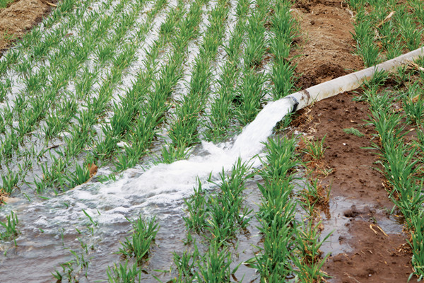
Most provinces in China predominantly consume "green water," soil moisture derived from rainfall, for agriculture, but some provinces in the dry north of the country also use substantial amounts of "blue water" through irrigation. Credit: ©Shutterstock.com/chinahbzyg.
Since their early use, methods for calculating virtual water content and analyses of virtual water trade have been updated frequently. These updates have been spurred partly by improvements in and the greater availability of data about trade, water consumption and hydrology, and partly by criticisms over the techniques’ shortcomings.
A common concern with early virtual water studies was scale: They focused mostly on international trade and averaged the virtual water content of goods over large regions, often masking substantial variations in water availability and consumption at smaller scales. Thus, they also tended to espouse solutions to water scarcity from a singular global perspective. But unlike greenhouse gas emissions and carbon footprints, “water scarcity and water quality aren’t global issues,” Wichelns says. “The problems are generated locally, and they need to be solved locally.”
Increasingly, though, studies are targeting these smaller scales — within individual countries, states, river basins or even cities — to get a more accurate and relevant picture of virtual water flows and their impacts. “We used to use average country-level climatic data,” notes Ashok Chapagain, science director of the Water Footprint Network, a Netherlands-based nonprofit that is the driving force behind the water footprint concept. “Now,” Chapagain says, “we have river basin-level data” to go on.
“A key conversation here is really about cities,” Ruddell points out. “Patterns of water use are really driven not by countries, they’re driven by cities,” he says, which are “the hubs of all this water use and trade in virtual water.” As an early demonstration, he and his colleagues have begun studying virtual water flows in relation to the local economy and city government decision-making in Flagstaff, Ariz. The work “has to do with what you are using the water for, what value you are creating, in terms of jobs and money, what you are getting for your water use, and how we are dependent on our neighbors at a very small scale,” he says.
Distinguishing among green, blue and gray water helped address another early criticism of virtual water studies: that they treated all water as equal when in reality, the value — financial, cultural and environmental — of rainfall versus river water, for example, may vary drastically. Over time “the data have been refined and the methods have been refined”; it’s an ongoing process, Chapagain says.
But there is still plenty of room for improvement in virtual water accounting. For one thing, how best to measure gray water and how comparable it is to green and blue remains unclear. “Water pollution is … a very different issue from consumptive water use,” Ruddell says, adding that he isn’t certain the two issues can realistically be combined under one umbrella concept, at least based on existing methods.
Other inconsistencies in how virtual water and water footprints are tallied remain as well, making numbers and trends difficult to compare across studies. How far upstream through supply and production chains one accounts for in calculations, for instance, will clearly affect the results, as will the quality of data available in different areas. However, as long as the scope and goals of virtual water and water footprint assessments are clearly laid out and acknowledged, Chapagain says, confusion over such inconsistencies can be mitigated.
There have been efforts to standardize procedures: In 2011, the Water Footprint Network published a “global standard” manual for outlining and conducting footprint assessments. And the International Organization for Standardization recently published guidelines for determining and reporting water footprint assessments. Yet, it’s uncertain whether these standardizations, which themselves consider different definitions of and approaches to water footprints, will be broadly accepted and incorporated.
Most supporters of the virtual water and water footprint notions acknowledge some weaknesses while continuing to stress their usefulness. Volumetric indices alone are not sufficient to determine the sustainability of water use related to any particular crop, product, company or country, Chapagain says, but they are “the most essential [pieces of information] that you need.” Rodriguez-Iturbe adds that modeling of virtual water trades is an important tool for planners, but it is not a “magic bullet” to solve problems.
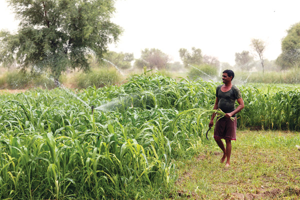
Crop irrigation in India. Credit: ©OneRedEye via SABMiller.
If there is one application of virtual water flows and footprints that most people in the debate seem to agree on, it’s that these methods may be useful for multinational corporations and businesses. Recently, businesses have started using the concepts, “not only to understand how much virtual water they are importing and in what river basins their footprints are located, but … to understand what the risks are to their supply chains,” Chapagain says.
“All else being equal, your business is going to be more secure and more profitable if you eliminate risky and unsustainable suppliers from your supply chain,” Ruddell says. “So you might want to know, for example, if you’re doing business with a supplier whose water footprint and virtual water trade are really creating problems for the local water supply.” If that happens, he says, a company’s brand is at risk and there is “potential for political conflict, for lawsuits, even for violent conflict.”
And indeed, a number of major companies — SABMiller, PepsiCo and Nestlé among them — have adopted the approach in the last several years, producing reports of their own virtual water usage. Brewing giant SABMiller’s 2010 report, for example, offered case studies detailing its operations and footprints in water-stressed areas of Peru, South Africa, Tanzania and Ukraine.
If companies want to calculate their water footprints, they “should be free to do whatever they wish to do,” Wichelns says. But, he says, they should not be “required to do it in a policy framework in which that information is going to be used to allocate water resources or to evaluate who is using water wisely and who is not, because that’s where those measures are just too myopic.”
Businesses, Witmer says, are typically in a better position than governments to identify unsustainable hot spots in supply chains, where water resources are being threatened through overuse or pollution, because they know in detail where their materials and services are originating. The problem with regulations obliging companies to report and possibly minimize virtual water usage is that “every company is different and every country is different,” Witmer says. The fair solution, she adds, is for governments, companies, nongovernmental organizations and researchers to cooperate to recognize and deal with water issues.
© 2008-2021. All rights reserved. Any copying, redistribution or retransmission of any of the contents of this service without the expressed written permission of the American Geosciences Institute is expressly prohibited. Click here for all copyright requests.