
by Lon Abbott and Terri Cook Tuesday, October 16, 2012

Installing the seismometers of the Transportable Array (TA in Milan, Mich. The TA seismometers remain in place for two years before being moved. Incorporated Research Institutions for Seismology
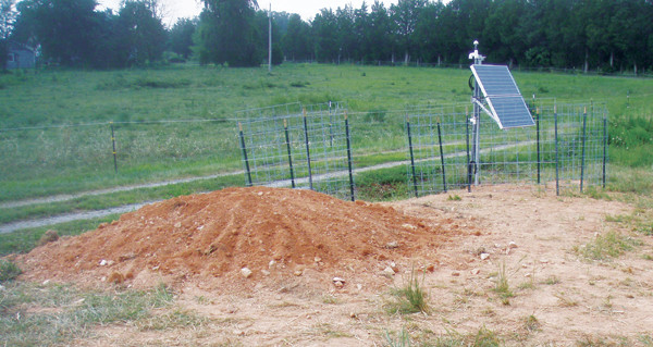
Installing the seismometers of the Transportable Array (TA) in Mineral, Va., near where a magnitude-5.8 earthquake struck in August 2011 Incorporated Research Institutions for Seismology
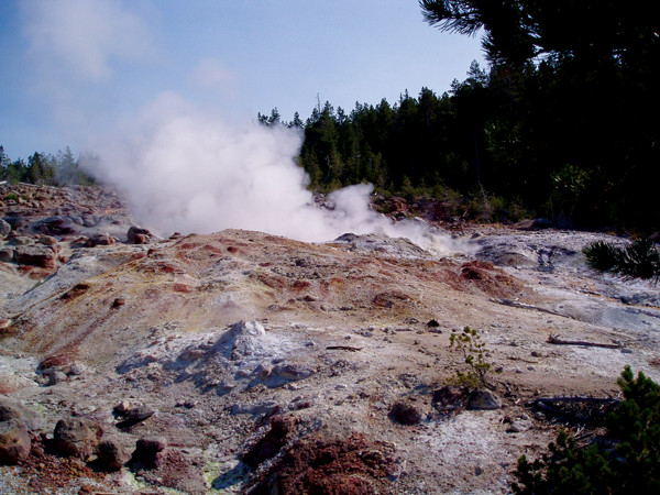
Part of the High Lava Plains project looks to explain the volcanism in Yellowstone. Megan Sever
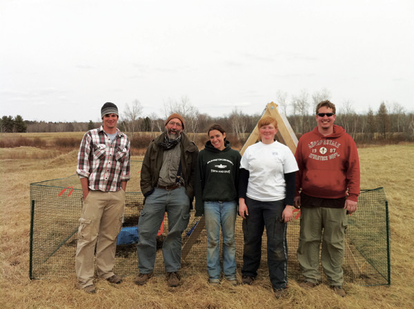
Students, professors and technicians installed seismometers in the Upper Midwest and Ontario as part of the SPREE project. Courtesy of Suzan van der Lee
Big science often requires big tools. Particle physicists use huge particle accelerators. Astronomers need enormous telescopes to peer to the edge of the cosmos. Because of their need for large, expensive instruments, scientists in these disciplines are accustomed to forming consortia that advocate for the financial resources necessary to construct the tools of their trade. Earth scientists, by contrast, normally probe the planet individually or in small groups using comparatively inexpensive instruments, even considering ocean research vessels. This “small science” approach has served us well; using it, we have learned a great deal about how Earth works.
One of the great achievements of earth science is understanding plate tectonics. But as is typical in science, one discovery begets many new questions. As our knowledge of tectonic processes has grown over the years, it has become increasingly clear that our most pressing questions about continental tectonics could not be answered unless we designed and built an instrument capable of peering deep into the planet with unprecedented resolution. Among the questions such an “Earth telescope” could address include: How is continental crust created and destroyed? How stable is the continental lithosphere? What happens to a subducted slab? And how do hot spots form?
An Earth telescope would look nothing like an astronomer’s telescope, obviously; instead it would consist of a grid of seismometers that record the seismic waves emanating from earthquakes. Some types of seismic waves travel through the entire planet, from the crust to the core, and can be detected half a world away from the earthquake that created them. The speed of a wave en route from source to receiver is a function of the properties of the rock through which it passes. Deviations from the expected wave speeds reveal areas of anomalously hot or cold material. And maps of those anomalous wave speeds allow seismologists to discern, among other things, where cold subducted slabs are sinking, where hot mantle material is rising, and where solid blobs of relatively cold lithosphere drip into the deep mantle, like wet paint dripping off a ceiling.
After years of planning, we now have such an Earth telescope. It’s called USArray and it’s part of EarthScope — the largest and most expensive earth science project ever undertaken, funded by the National Science Foundation. From it, we are learning more about how the deep Earth works than was previously possible, including how the mechanism driving volcanism below Yellowstone works and what might be driving seismicity in the Midwest.
EarthScope was conceived in the 1990s when several groups of American earth scientists began to lobby for the financial resources necessary to build the Earth telescope. In 2003, Congress authorized $30 million in seed money as a down payment on EarthScope. In 2004, the program got under way. EarthScope consists of three separate but related efforts: the San Andreas Fault Observatory at Depth (SAFOD), which is a borehole that cuts through the San Andreas Fault 3.2 kilometers below Earth’s surface; the Plate Boundary Observatory (PBO), which consists of 1,100 GPS stations and other geodetic equipment that documents the strain field across the plate boundary along the West Coast; and the USArray, the grid of seismometers that forms the Earth telescope.
USArray’s primary component is called the Transportable Array (TA). The TA is a network of 400 broadband seismometers that are simultaneously deployed in a tight grid, with approximately 70 kilometers between stations. This huge footprint has earned it the nickname “Bigfoot.”
The first Bigfoot deployment began on the West Coast in 2004, with a grid stretching from Canada to Mexico. Each seismometer remains in the ground for two years, recording both distant and nearby earthquakes. When the two years are up, seismometers on the west side of the array are pulled up and transported to new locations on the grid’s east side. In this manner, the seismometers leapfrog across the country, ensuring that at any given time a regional swath of land is blanketed by seismometers. Currently, Bigfoot covers the country’s midsection from Minnesota to Florida, and it will continue marching eastward, covering the rest of the East Coast by 2014 before moving on to Alaska. When the project is done (slated for 2018), geoscientists will possess data on Earth’s deep structure beneath the country’s entire 2 million square kilometers.
An important augmentation to Bigfoot is the Flexible Array (FA), a group of more than 2,100 additional seismometers that individual researchers can deploy to fill in the grid between the TA stations, allowing them to sharpen the network’s resolution even more in those areas of greatest research interest.
Before we had Bigfoot, seismologists had to gather all the seismometers they could lay their hands on and install them either in a local grid or in a long line. Ask any seismologist and they’ll tell you they never had enough.
Bigfoot provides two advantages over such local deployments. First, because Bigfoot records data simultaneously across a wide swath of the country, scientists can now examine the deep earth’s physical properties on a regional rather than just a local scale. Secondly, the close station spacing, made even tighter by strategic infilling with FA stations in key areas, allows scientists to produce deep Earth images of unprecedented resolution at a regional scale. This is just the prescription for testing ideas about the structure, function and history of the deep Earth.
David James, a seismologist at the Carnegie Institution for Science in Washington, D.C., says that geologic-scale imaging of the deep structure beneath the continent is something that even 20 years ago was nearly impossible but that with USArray is becoming almost routine. “All my professional life I have moaned about the fact that we never had enough data, but I think that with USArray ... we are finally going to have almost all [the data] that we can handle for many years to come,” James says.
In the same way that individual astronomers utilize a major telescope as a tool to answer the specific questions that drive their own research, USArray is not one big study of the U.S. but rather a tool utilized by small teams of earth scientists to perform a collection of studies. The array’s raw data are available to anyone. In just its first eight years, USArray has already improved our understanding of the deep structure beneath the western United States.
One such study is called the High Lava Plains project. James and fellow Carnegie Institution seismologist and EarthScope National Office Associate Director Matt Fouch, along with other colleagues, are trying to determine what produced so much lava in the Columbia River/Yellowstone region, the most volcanically active area in the continental United States. Between about 17 million and 14 million years ago, 235,000 cubic kilometers of basalt lava — enough to bury the region to an average depth of about a kilometer — poured out of and across the high plains of Oregon and Washington, then later spread along the Snake River Plain northeast to Yellowstone. The older basalt province is known as the Columbia River flood basalts and the younger volcanism is referred to as the Yellowstone Hot Spot.
None of the accepted paradigms of how such large volumes of magma are produced fit all of the available data. Other flood basalt provinces, such as the Deccan Traps in India and Russia’s Siberian Traps, have been attributed to so-called hot spots, in which plumes of hot material rise from the lower mantle, producing magma that erupts in a flood of volcanic activity. Hawaii was formed as the Pacific Plate migrated northwestward over one such plume, producing a chain of progressively younger volcanic islands. It has been proposed that the Columbia River flood basalts and the subsequent Yellowstone Hot Spot formed over a similar plume.
Supporting the hot spot idea is a series of silica-rich rhyolitic eruptions on the Snake River Plain over the last 12 million years. The age of the eruptions decreases from southwest to northeast — a progression that tracks the direction and rate of motion of the North American Plate. In this model the mantle plume lies today beneath the volcanically and hydrothermally active Yellowstone National Park.
But fluid dynamics theory teaches us that, mechanically, it is much easier for such a deep mantle plume to rise uninterrupted in the middle of a big oceanic plate, such as occurs in Hawaii, than under a continental plate. So, despite the fact that the idea of a Yellowstone hot spot plume is deeply embedded in both the popular and the scientific literature, not all experts have embraced the plume explanation for the Columbia flood basalts and the Yellowstone Hot Spot.
In addition to the theoretical concerns, three observations are inconsistent with the plume model. First, although the Snake River Plain rhyolitic eruptions become younger to the northeast, as one would expect for a stationary plume beneath a southwestward-moving North American Plate, the basaltic volcanism does not follow this same temporal trend. Young basaltic volcanoes exist at both the eastern and western ends of the Snake River Plain. Second, simultaneous with the northeastward migration of rhyolitic volcanism toward Yellowstone, another wave of volcanism migrated northwest, nearly perpendicular to the Yellowstone trend. How could plate migration over a plume simultaneously explain two perpendicular volcanic trends? Finally, although the ratio between two isotopes of helium found in the basalts indicates that the magma was generated in the lower mantle, as is required for the plume hypothesis, several other geochemical signatures of the flood basalt lavas are instead more consistent with the origin of these magmas in the upper mantle.
To determine whether a mantle plume underlies Yellowstone or whether the lava was produced by a different mechanism, geophysicists turned to seismic waves, which can image the temperature of the underlying mantle. Seismic waves travel more slowly through hot material than they do through cold, so if the Yellowstone caldera is being fed by a plume rising from the deep mantle, it should be possible to see the plume in images of seismic data.
The geophysicists on the High Lava Plains project set out to harness the Bigfoot Earth telescope, augmented by FA stations, to peer at the deep structure under the entire region, from the Columbia River flood basalts all the way to Yellowstone. The sharp seismic images their study produced allowed them to scrutinize the entire plumbing system beneath the volcanic province in unprecedented detail.
They found that hot material extends from the crust-mantle boundary down through the upper mantle to a depth of about 400 kilometers beneath both the Snake River Plain and Yellowstone. But below that depth is a portion of anomalously cold material, which, the High Lava Plains team concluded in a paper in Earth and Planetary Science Letters last year, is a stranded remnant of the subducted Farallon slab.
About 230 million years ago, the Farallon Plate started subducting under the West Coast of North America, fueling a chain of subduction zone volcanoes in California’s Sierra Nevadas. Most of the plate has subsequently been subducted and now lies beneath the continent, although a remnant of it, the Juan de Fuca Plate, remains. The Juan de Fuca is still subducting off the coast between Northern California and southern British Columbia, and is fueling the Cascades volcanoes. James and colleagues think that the Farallon slab remnant detected by the High Lava Plains project tore away from the rest of the plate, with the tear running parallel to the northwest edge of the Yellowstone/Snake River Plain hot spot track.
The scientists suggested that the slab’s presence effectively blocks the direct flow of heat from the deep mantle. Instead, their seismic images, based on data from USArray, reveal that heat rising from the deep mantle is curling around the leading tip and the torn, northwestern edge of the Farallon slab fragment. The observed change in mantle convection beneath the region matches the predictions of both numerical and physical models of what should occur around a slab of cold, subducted lithosphere at depth.
The team concluded that the Columbia River flood basalts and the Snake River Plain/Yellowstone volcanism were not created as the North American Plate progressively moved across a stationary mantle plume; instead, this volcanism is the product of the disturbance of mantle convection patterns triggered by fragmentation of the Farallon slab during subduction.
Much research remains to be done as the project scientists and others continue to unravel the data, but the results show promise for helping reframe the scientific dialog about fundamental processes taking place beneath North America.
In 2011, Bigfoot crossed the Mississippi River, where unlike in the West, the tectonic structures are buried deep beneath a blanket of young sediments. Geologists therefore know far less about the region’s underlying structure and its tectonic history, not to mention possible Midwestern seismic hazards. We do know that in the past, the Midwest has been the site of mountain building events during plate collisions and aborted episodes of continental rifting. And we know that destructive earthquakes do occur in the region, although we don’t have a great grasp on why or how. So USArray may be an even more important tool for learning about the middle of the country than it is in the West.
Three studies that are just getting under way now that Bigfoot has crossed the Mississippi illustrate the promise that USArray holds for producing exciting scientific discoveries in the years to come. These projects are known as SPREE, NELE and OIINK.
SPREE (Superior Province Rifting EarthScope Experiment) aims to study a prominent part of the 1-billion-year-old Midcontinent Rift, which runs from Ontario to Kansas. This part of the rift contains at least 500,000 cubic kilometers of volcanic rocks, about double the volume of the Columbia River flood basalts. Some scientists attribute the rift to the activity of one or more hot spot plumes (similar to today’s East African Rift), whereas others propose that it formed in response to the stresses imposed by a more distant plate collision, part of the assembly process of the supercontinent Rodinia, the predecessor of Pangaea. Curiously, rather than following pre-existing sutures, the rift cuts across major changes in crustal building blocks.
Regardless, all indications are that a billion years ago, this rift was on its way to ripping North America in half and filling the gap with a new ocean basin. But for reasons we don’t understand, the rift failed and the North American continent was left wounded but intact. SPREE scientists are using USArray to try to decipher why the rift started, how it might have failed and particularly how it related to the craton, the deep, strong keel of North America. To study the rift’s deep structure, SPREE scientists have recently installed FA stations between Bigfoot stations in Minnesota and Wisconsin and deployed others in adjacent portions of Ontario to cover the northern portion of the ancient rift.
Another mid-continent study, NELE (the Northern Embayment Lithosphere Experiment) is operating farther south and looking largely at the Mississippi Valley’s New Madrid Fault Zone, which in 1811 and 1812 unleashed a series of powerful earthquakes thought to have exceeded magnitude 7. Like most USArray studies, NELE will install FA stations to augment Bigfoot. These will run along two lines perpendicular to the Mississippi River and a third line roughly parallel to it over the area of the historic New Madrid quakes. With NELE, scientists hope to better understand the complex geologic history of the area now occupied by the New Madrid Fault Zone — where a comparable earthquake today could be devastating — and study the implications of that history for the zone’s current level of seismic risk.
A third big Midwestern project, OIINK — for Ozarks, Illinois, Indiana, Kentucky — is designed to probe the boundary between the Ozark Dome and the adjacent Illinois Basin. The Ozark Dome is the largest of several “intracratonic domes” that dot the Midwest. Intracratonic domes are uplifts that were not formed directly by tectonic plate convergence, the way most mountain ranges were formed, in a process known as orogeny. Scientists know how orogenic mountain ranges, like the Rockies, and their adjacent basins form. However, we don’t know much about the formation mechanism of intracratonic domes and their adjacent deep basins.
Based on the comparatively modest surface relief between the Ozark Dome and the Illinois Basin, these might seem like relatively minor features. But the young sediments that blanket the basin conceal a feature of Rocky Mountain proportions: a 7-kilometer vertical difference between the elevation of Precambrian rocks on the Ozark Dome (about 200 meters) and those that lie buried at the bottom of the Illinois Basin (about 7,000 meters below sea level). This rivals the offset between the Precambrian rocks atop Pikes Peak (4,300 meters) and those buried beneath the adjacent Great Plains (4,000 meters below sea level), says Steve Marshak, a structural geologist at the University of Illinois at Urbana-Champaign and an OIINK co-principal investigator. The Ozark Dome-Illinois Basin boundary is a major structure whose presence demands explanation, he says.
The installation of OIINK’s FA stations won’t be finished until this fall, but thanks to some creative instrument juggling, researchers got a handful of seismometers into the ground last year as a preliminary augmentation to the Bigfoot stations. Not only have data from that partial network helped the team to refine their deployment plan for the FA stations, the network also detected an unusual, low frequency seismic pulse on the morning of Feb. 29, 2012, just before a deadly tornado struck nearby. Indiana University seismologists Gary Pavlis and Michael Hamburger, OIINK principal investigator and co-principal investigator, respectively, interpret the pulse to be the recording of a brief pressure change associated with the thunderstorm that spawned the tornado. They suggest that analysis of such signals will shed light on the atmospheric changes that occur just before a tornado develops, thereby contributing to an important question in atmospheric science in addition to the tectonic and earthquake work for which the network was designed.
USArray has already successfully illuminated the deep structure beneath the western United States, providing scientists with compelling new data that have caused them to think in new ways about important features such as the Yellowstone Hot Spot and many others. We don’t yet know what Bigfoot will see as it peers deep beneath the Midwest or at its future destinations along the eastern seaboard and Alaska.
One thing seems certain, however: Earth scientists will use this powerful Earth telescope to make seminal discoveries for years to come.
© 2008-2021. All rights reserved. Any copying, redistribution or retransmission of any of the contents of this service without the expressed written permission of the American Geosciences Institute is expressly prohibited. Click here for all copyright requests.