
by Michael C. Wilson and Lionel E. Jackson Jr. Monday, February 8, 2016
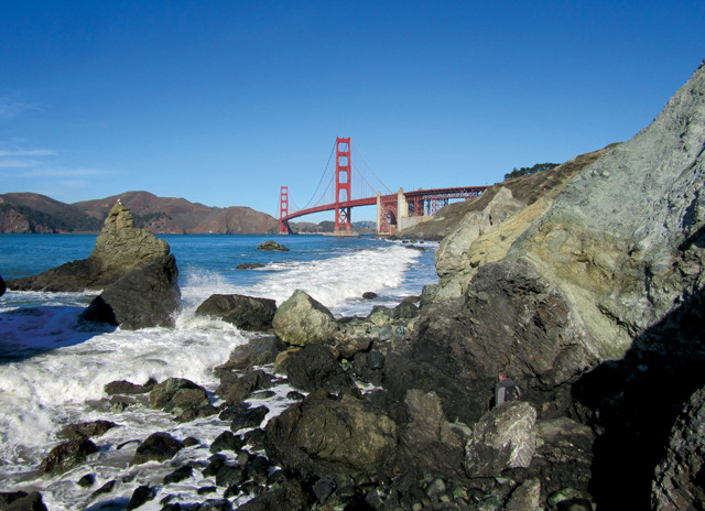
At Marshall's Beach south of the Golden Gate Bridge in San Francisco, the Franciscan mélange is exposed. During last year's annual meeting of the American Geophysical Union in San Francisco, geologist Callan Bentley and others visited the site to photograph the rocks. Credit: Callan Bentley.
The mass urbanization of the human race is a relatively new phenomenon in the history of civilization. In 1900, when geology was maturing as a science, only 10 percent of the global population lived in urban settings; now, this proportion has surpassed 50 percent, fed by both overall population growth and rural-to-urban migration. And by 2030, it is expected to reach 60 percent. The United States reached 50 percent urbanization around 1930 and is now approaching 70 percent. The urban population of Canada, meanwhile, accounts for about 80 percent of the country’s people. Ten urban areas around the world now exceed 20 million people, with the Tokyo metropolitan area approaching 35 million — larger than the populations of most countries.
The word “geology” conjures images of wide-open country with expanses of rocky outcrops rather than the concrete, asphalt and steel of urban landscapes. Despite the fact that most geologists live in cities, many still don’t think of cities as having much to do with geology. Most geologists don’t study or teach the geology of cities or do fieldwork in urban areas. When it comes to fieldwork, most still head out to the hinterlands where rocks and sediments are readily observable. However, many practical applications of geology today are just outside our front doors — or perhaps under them — in urban areas where most of humanity lives, works, plays and builds community. As Henry David Thoreau wrote in his journal in 1856: “It is in vain to dream of a wildness distant from ourselves.”
We advocate that urban geology should be recognized as its own specialty because its applications potentially impact more than half of the global population. We are not alone. Some countries, such as the United Kingdom, the Netherlands and China, explicitly acknowledge urban geology as an area of study, and the term “urban geology” has seen wide international usage, as in the multivolume U.N. “Atlas of Urban Geology.” However, it is still not widely recognized in the U.S. or Canada, despite the potential benefits — integrating everything from hazard mitigation and water supply issues to urban design and tourism.
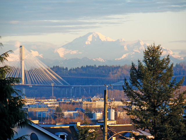
Even in a city like Vancouver, B.C., with volcanoes in plain sight and a history of (and potential for) major earthquakes, many residents are unaware of the geology of the region. Credit: Michael Wilson.
In the broadest terms, urban geology is the application of the earth sciences to problems arising at the nexus of the geosphere, hydrosphere and biosphere within urban and urbanizing areas. In this way, it goes beyond the application of geology in civil engineering (commonly called “engineering geology”). Urban geology draws on the entire toolbox of the earth sciences, from stratigraphy to geochemistry and hydrogeology to geophysical exploration techniques; and it often makes linkages to the biological and environmental sciences.
Both of us have been actively contributing to the field of urban geology. During the Geological Society of America (GSA) annual meeting in Vancouver, British Columbia, in October 2014, we organized a session entitled “Urban Geology: An Emerging Discipline in a Changing World” that we hoped would attract like-minded earth scientists. We were delighted by the geographical diversity of the presenters and attendees and the topical diversity of the presentations.
The presentations gave a taste of the breadth of urban geology: mapping of bedrock and surficial geology in urban areas in Wales; geological mapping of active faults around Seattle; environmental geochemistry, hydrology and groundwater quality in rivers of the U.S. Midwest; mapping geology and arsenic contamination in de-urbanizing Detroit; the role of windblown dust in importing contaminants from surrounding agricultural areas into urban areas of the Sonoran Desert region of Mexico; and geoheritage around the world. All speakers emphasized the cross-linkages and interactions of diverse Earth processes, together with the importance of the human element of urban population concentrations. Our associated field trip illustrated reference geological sections, raw material resources and geoheritage considerations, as well as how Vancouver’s geological setting is manifested in geologic and hydrologic hazards, including areas where geological settings prevented or limited development.
Although urban geology — along with the idea that humans impact the landscape — is still an emerging field now, two 19th-century U.S. Geological Survey (USGS) geologists were early visionaries. Maj. John Wesley Powell, explorer of the Colorado River and second director of USGS, was dubious about the sustainability of agriculture and urbanization in the deserts of the American Southwest. His former assistant and fellow USGS geologist, Grove Karl Gilbert, expressed similar concerns in regard to settlement of drought-prone areas of the Midwestern and Western states.
Although their views met with opposition, the dust bowl era of the 1930s vindicated their concerns. Gilbert in particular saw the rub between urbanization and the geological environment: He documented the negative aspects of humans as geologic agents in terms of the impact of large-scale hydraulic placer gold mining in the Sierra Nevada Mountains on the flood hazards in cities in the Central Valley of California. He also documented the earthquake in 1906 in San Francisco and the problematic location of that and other cities along the San Andreas Fault. Such conclusions by Powell and Gilbert generated a strong push-back by pro-development interests of the day, right up to the floor of Congress.
Investigation of urban geology gained traction with the 1973 publication of “Cities and Geology” by Anglo-Canadian civil engineer Robert Legget. The book opened eyes to the diversity of earth science linkages within the urban environment and was coincident with the first concerted efforts in urban geology on a national scale in the United States. In the vanguard were studies undertaken in the early 1970s through the collaboration of the U.S. Department of Housing and Urban Development (HUD) and the USGS. A series of “HUD studies,” as they were known, started in the San Francisco Bay Area. Additional HUD studies of the Connecticut Valley, Baltimore-Washington, D.C., Pittsburgh, Denver, Phoenix-Tucson and Puget Sound areas followed. The USGS also produced an Atlas of Urban and Regional Change as a series of open-file reports in 1975. This flurry of activity was, in part, a response by the Nixon Administration to the perceived growing political strength of the environmental movement.
In Canada, the Geological Survey of Canada (GSC) was proactive in urban geology between the late 1970s and 1990 and even had a short-lived urban geology subdivision. Important compilation volumes involving government, academic and private-sector contributors were published by the Geological Association of Canada (GAC) in the late 1990s. The GSC’s Geoscape series, spearheaded by Bob Turner and John Clague then of the GSC, centered on Canadian cities in their regional geological contexts, bringing detailed geological information in poster and digital form to the general public. Unfortunately, by the late 1990s government funding cutbacks and a renewed emphasis on geological mapping in support of mineral exploration relegated these initiatives to the “back burner” in Canada, and much of the impetus for coordination was lost.
We began our formal involvement in urban geological studies in the 1970s, with Jackson mapping and investigating patterns of natural and human erosion and sedimentation as a part of the San Francisco Bay Region HUD study and Wilson investigating the surficial geology and geoarchaeology of Calgary. When Jackson moved to Canada, we joined forces in Alberta to produce our co-edited 1987 volume, “Geology of the Calgary Area.” One of the chapters of that volume, by Gerald Osborn, documented the flood hazard facing Calgary. This was widely ignored or denied by successive city councils until 2013 when a devastating but sadly predictable flood struck Calgary and much of southwestern Alberta, resulting in the most expensive natural disaster in Canadian history. That flood was, notably, smaller than the largest historically recorded flood, which occurred in 1897.
More recently we have teamed up again to study the potential for urban geology as an integrative discipline, focusing our attention on the Vancouver metropolitan area in British Columbia. We have documented important reference sites, are integrating new data from geotechnical and other sources, and have investigated the heritage role of geology in building an urban sense of place. We are hoping to use this information to help advocate for urban geology as a discipline.
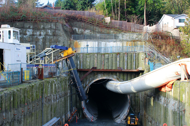
North portal of a new SkyTrain tunnel in Port Moody, B.C. The tunnel ascends 90 meters over a 2-kilometer distance through sediments equivalent to the Coquitlam gravel pit section and terminates in glacial marine sands deposited when the Cordilleran Ice Sheet retreated and the sea invaded the then-isostatically depressed greater Vancouver region. The variable geology caused many challenges for "Alice," the tunneling machine, and the engineers guiding it. Credit: Lionel Jackson.
The geology of urban centers might be thought of as being “sealed off” by buildings and pavement, which seem to hide the profoundly disturbed ground below. But in truth, construction activities often expose undisturbed remnants hidden between buildings or under pavement. Small excavations occur constantly, briefly revealing soil, unconsolidated material and rocks, which if studied, can provide valuable new data and interpretations. These temporary exposures can, over time, permit fine-scale, three-dimensional mapping of geological units, especially of Quaternary sediments. Additionally, temporary exposures and borehole data record depth-to-bedrock or other markers, potentially revealing valleys filled with generally weaker, variably permeable material — important information for engineering geology and groundwater studies, for example. The archiving of such data may be well organized in some cities, but for others it is spotty, piecemeal and lacking integration.
Bigger projects, like geotechnical drilling for subways and other large infrastructure projects — such as a new extension to the Metro Vancouver SkyTrain transit system — can provide extensive stratigraphic data. Boreholes drilled for a 2-kilometer-long tunnel associated with the SkyTrain system have intersected sediments deposited by at least two glaciations in the area, and have documented more than 100 meters of sea-level rise and fall related to isostatic depression and rebound and eustatic sea-level change. Elsewhere in Metro Vancouver, cores from undisturbed stratigraphy can be collected in natural parks and agricultural reserves, as well as in many areas of the city where steep terrain and narrow ravines prevented development. Insights from such cores and boreholes can be used to create detailed geologic frameworks of urban areas.
The challenge is to consistently record and store such information for retrieval. By and large, geotechnical consulting companies have been leaders in collecting such data, but the information may be proprietary or part of their knowledge-based capital, possibly only available to citizens or city governments for a fee.
Archiving such data is also a challenge. It may be well organized in some cities for periods of time but then discontinued due to budget cuts or a seeming lack of immediate benefits. Calgary and Vancouver both had registries of borehole logs in the past, many of which still exist, but those on paper or spools of magnetic tape require processing and compilation for integration. This underscores the need for cities and states to have agencies whose missions are to accumulate and store such information.
Logistical challenges aside, there is also a mindset challenge: Even geotechnical companies working in a metro area can’t gather urban geologic data from ephemeral exposures on a regular basis in an economical manner. With a few exceptions, such systematic data collection and archiving is not of interest to university academics either. This work is generally not in their personal or economic interest considering that promotions and professional recognition tend to be based on publications related to what’s considered cutting-edge science. In fact, while working as a research scientist with the government of Canada, Jackson was once discouraged from applying for a promotion because his applied work in natural hazards in and around urban areas was called “not sufficiently high-level science.” A supervisor put it bluntly: “You have wasted your career doing useful things.” Similarly, as an undergraduate, Wilson was told by a professor that a study of the Calgary area would be “a waste of time and talent.” Thus, we must find a way to make people care about urban geology before we can possibly get them to do anything about it.
At the National Zoo in Washington, D.C., Bentley discusses the geology of the bedrock beneath the D.C. area — specifically the Taconic Orogeny and the Rock Creek Shear Zone — as part of an annual event called "WalkingTown DC," which offers walking tours of the city on various topics. Credit: Mara Cherkasky, Cultural Tourism DC.
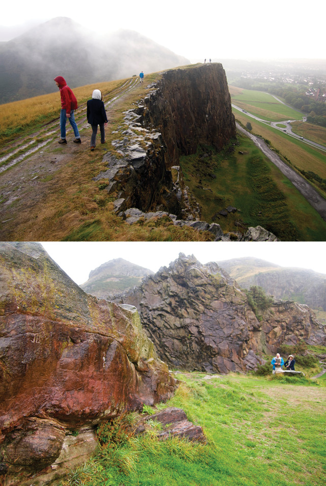
Arthur's Seat, part of the 350-million-yearold Arthur's Seat Volcano in the heart of Edinburgh, Scotland, is an example of geology that can be found in urban areas. Between Arthur's Seat and the center of the city lie the Salisbury Crags basalt cliffs, which include an area known as Hutton's Section, named after geologist James Hutton. Credit: both: Mary Caperton Morton.
By its nature, urban geology is within the realm of the generalist geologist. An urban geologist should have a grounding in basic geology, with proficiency in stratigraphy, geohydrology, engineering geology and geochemistry. A solid understanding of the natural hazards that cities face is also vital, as are good communication skills because work must often be explained to a variety of stakeholders.
Urban geologists also need to be problem-solvers. They rarely have the opportunity to propose unique solutions; instead, typically, they are left to explore the alternatives available to citizens, to inform what will still be politically driven decisions. A good example was a project in which Jackson was involved in the Reinaldo Espinosa neighborhood in Loja, Ecuador. Landslide movement had devastated parts of this suburb but left other parts untouched. Drilling and geological mapping identified the limits of the landslide and identified its mechanism of movement, which gave the community association the information needed to make informed land-use decisions. The city could establish a greenbelt — as Jackson and Ecuadorian colleagues suggested — or try to live with the situation and continue development. In the end, like the city of Calgary — which long ignored the fact that its downtown was situated on a floodplain — it was the city’s decision to make. The residents of Loja chose to eliminate development in the landslide area.
For cities that cannot hire an urban geologist or establish an urban geological survey, perhaps they could combine urban geology projects with educational programs. For example, a local university could have its students gather the wealth of temporarily available information from ongoing development projects as part of their training — call it “local fieldwork.” Another option would be letting local citizens help collect data. Urban geologists working for the government or a local university could collect and synthesize the “citizen science” data. This is happening already in some locations, such as Seattle, where volunteers host seismometers in their houses to record and report earthquake data to scientists at USGS and the University of Washington.
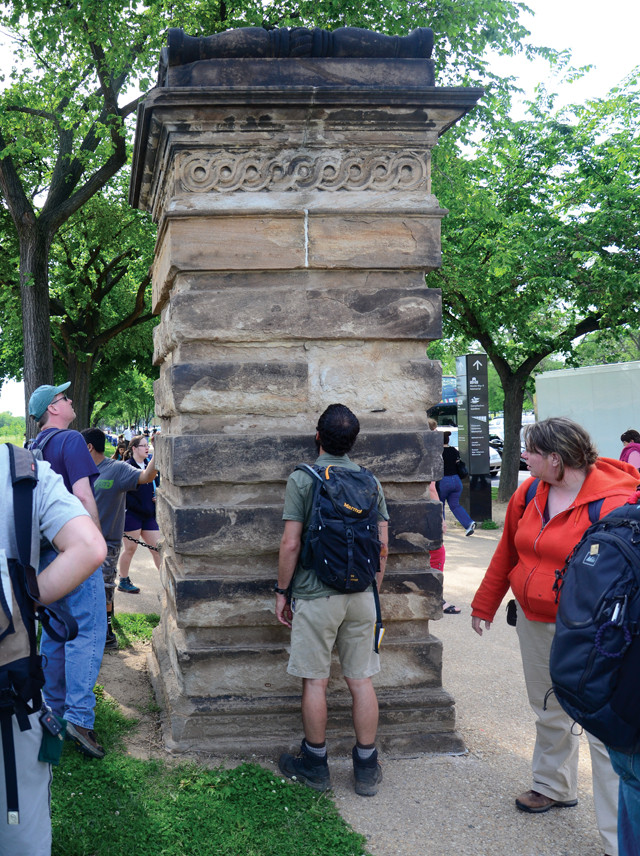
Geology students check out the building stone of one of the Capitol Gateposts in Washington, D.C., as part of an urban geology field trip. Credit: Callan Bentley.
Involving urban residents in citizen science projects educates them about the geology of their local area — a constant challenge for geologists, but an important component of outreach, especially in areas at high risk from hazards such as earthquakes. In the Vancouver area, we have been shocked at how few of our university students are aware that nearby Mount Baker — which looms over Metro Vancouver from its location in northern Washington — is a volcano that last erupted only 120 years ago and still steams from its crater. They are slightly more aware of subduction earthquakes and tsunami hazards because of news coverage of the recent Japanese earthquake and tsunami, and of landslides and floods because of local events within the past few years. But without reinforcement, these memories fade. It is incumbent upon geologists working in urban areas, who are usually licensed professionals, to work to educate people about their local risks as part of their commitment to public safety.
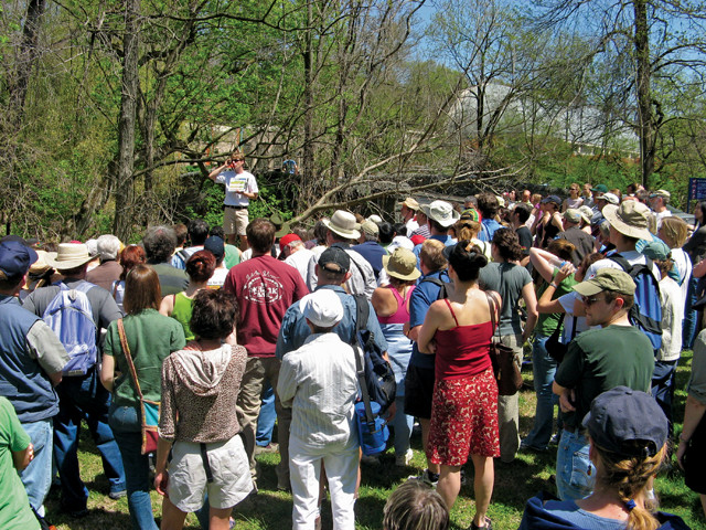
Urban environments also provide special opportunities for public outreach for positive reasons, such as urban field trips. For example, geologists in Vancouver, Seattle and Washington, D.C., have hosted urban walks to view and discuss the rich variety of building-stone types. Other such urban field trips could include hikes and bicycle rides through parks like Stanley Park in Vancouver, Golden Gate National Recreation Area in San Francisco, Earthquake Park in Anchorage, Alaska, or Laupahoehoe Beach Park (informally known as Tsunami Park) in Hilo, Hawaii. Urban field trips are valuable, even when exposures are relatively few. Close attention to small outcrops can be highly instructive, offering an opportunity to build durable, valuable databases and to foster public understanding.
Worldwide, there has been a growing movement to develop geoheritage sites; in late 2015, UNESCO formally adopted the Global Network of Geoparks, designating geoparks as official UNESCO sites. While most geoparks and other geological heritage sites are located in more remote areas, some are in urban areas and can contribute to a sense of place, helping bring together people of diverse origins. While not a geopark, one such geoheritage feature is Siwash Rock in Stanley Park (see Siwash Rock as an urban geoheritage icon sidebar), beloved by many in Vancouver: The rock provides a commonality among people in this region. Such geologic features in urban areas become residences of history, serving as memory devices for associated geological histories, stories, explanations and behavior, and reflexively influencing human behavior.
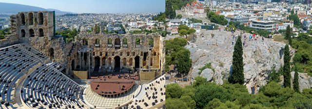
Geology can be found everywhere. In the heart of Athens, Greece, the hill of the Acropolis (upon which the photographer stands in both pictures) is an incongruous piece — called a klippe — of 100-million-year-old limestone (seen above). The rest of the city is built on 70-million-year-old lightly metamorphosed bedrock called the Athens Schist. Credit: both: Lon Abbott and Terri Cook.
Legget’s desire to make urban geology accessible to the general public has seen important progress since the 1970s, but challenges remain. Formal urban geological surveys at the city government level would be the logical approach. They would not supplant the work of private geotechnical contractors; rather this would involve the sharing of information from all sources to enrich those efforts. Rapid response ability is vital where exposures are temporary (see Urban type sections sidebar): Foundation and basement walls can be coated in concrete within hours of exposure, for example. Continuity is a key concern, so attachment of the survey to a college or university (or an active research museum) would be a good approach. But funding such entities on a continuing basis would be a challenge.
Barring establishment of urban geological surveys, we see the need for GSA and GAC to establish urban geology divisions to coordinate academic and other professional contributions, because existing divisions like Engineering Geology or Geology and Society have broader, albeit overlapping, mandates. At the academic level, faculty should work to identify the knowledge base required for careers in urban geology, and then teach that to help students attain those careers.
Given that the global population living in urban areas is expected to climb to 66 percent by 2050, urban geology is only going to grow more important. The question remains: Will we anticipate the needs of a growing population and work proactively, or will we be trying to catch up with accelerating urbanization and, in the process, miss many of its opportunities?
© 2008-2021. All rights reserved. Any copying, redistribution or retransmission of any of the contents of this service without the expressed written permission of the American Geosciences Institute is expressly prohibited. Click here for all copyright requests.