
by Sara E. Pratt Monday, February 6, 2012
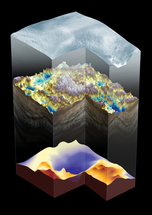
Three-dimensional perspective of the Gamburtsev Subglacial Mountains, including a view of the deep root imaged beneath the range and of the thinner crust of the East Antarctic Rift System that surounds the mountains. British Antarctic Survey
In 1958, geologists discovered a mountain range buried more than a kilometer beneath the East Antarctica Ice Sheet. For more than half a century, the origins of the Gamburtsev Subglacial Mountains have proven to be a geological puzzle, but a new study may have finally solved the enigma, and simultaneously given geologists a new understanding of mountain-building processes.
The Gamburtsevs lie under the highest point in Antarctica, the 4,000-meter-high Dome Argus Plateau. The mountain range, in the middle of an ancient continental craton, has a thick, crustal root and high topography, which has made the Gamburtsevs the least-understood tectonic feature on Earth for the past 50 years.
“The reason why the Gamburtsevs are so enigmatic is that stable cratons are generally low-lying features with no huge mountain ranges atop,” says Fausto Ferraccioli, a geophysicist at the British Antarctic Survey in Cambridge, England.
The Gamburtsevs are completely covered by ice, preventing scientists from recovering physical rock samples. Earlier studies that determined the root — all that remains of an earlier mountain chain — was at least Precambrian in age relied on indirect evidence: outcrops exposed to the north of the mountains, detrital zircons retrieved from ice cores, and seismic measurements that revealed a crustal thickness of 45 to 60 kilometers. Elsewhere in East Antarctica, the average crustal thickness is about 35 to 40 kilometers.
Ferraccioli and his colleagues used two Twin Otter aircraft equipped with ice-penetrating radar, laser-ranging systems, gravity meters and magnetometers to collect data over a 3-million-square-kilometer area between the South Pole and the Lambert Glacier. The data revealed a previously unknown extension of the East Antarctic Rift System — a 2,500-kilometer-long fracture that extends from East Antarctica across the ocean to India, which, when active, resembled today’s East African Rift System — making it the longest fossil rift system on Earth.
Finding the rift extension led the team to propose that the mountains are actually the result of multiple orogenies, or mountain building episodes, involving a unique combination of continental collision, rifting and uplift processes not previously seen together in other mountain ranges.
“We infer that the root may have formed about 1 billion years ago during the assembly of the supercontinent Rodinia,” Ferraccioli says. “However, sparse zircon data retrieved from small amounts of sediment inclusions entrained in accreted ice at Lake Vostok suggest that 1.8-billion- to 1.6-billion-year-old rocks may be present in the Gamburtsev Province,” he adds, which means the root could possibly be older.
The root is the last remnant of the proto-Gamburtsev mountains, which would have been completely eroded by the time the East Antarctic Rift System became active 250 million years ago. Rifting did not destroy the crustal root, but rather reactivated it by magmatic activity, the team proposed in Nature. With crustal thinning and stretching, the crustal root became more buoyant, isostatically rebounding out of the mantle, and uplifting the flanks of the rift zone to form the modern Gamburtsevs about 100 million years ago, the authors reported.
Steep downcutting and erosion of the rift flanks — first by rivers and then, about 34 million years ago, by the first glaciers of the East Antarctic Ice Sheet — further unloaded the crust, which buoyed the range higher, the authors suggested. Once a more stable continental-scale ice sheet formed about 14 million years ago, Ferraccioli says, the landscape became permanently entombed by ice and the peaks were preserved.
This series of tectonic events gives the Gamburtsevs an unusual orogenic history. “The preservation of old roots, rift flank uplift and isostatic response to incision have been observed in other mountain ranges. The unique aspect is the combination of these factors,” Ferraccioli says.
In an accompanying Nature commentary, John Veevers of Macquarie University in Sydney, Australia, who has analyzed nearly 1,000 zircons from the region, questioned the suggested alternative age of the crustal root, saying too few zircons were used in the analysis. However, Veevers’ zircon data indicate an age range for the crustal root of 1.15 billion to 850 million years, which supports Ferraccioli’s estimate of 1 billion years.
“The next steps will be to assemble a team to drill through the ice into the mountains to obtain the first rock samples from the Gamburtsevs,” says Robin Bell, a geophysicist at Columbia University’s Lamont-Doherty Earth Observatory and a co-author on the study. “Amazingly, we have samples of the moon but none of the Gamburtsevs.”
The rock samples will help narrow the timeline of root formation, reactivation, rifting and uplift. Nonetheless, Veevers wrote in Nature, “Ferraccioli and colleagues’ study provides the first comprehensive model to explain how a ragged topography can form in an ice-covered continental interior by modification of the underlying crust and lithosphere.”
© 2008-2021. All rights reserved. Any copying, redistribution or retransmission of any of the contents of this service without the expressed written permission of the American Geosciences Institute is expressly prohibited. Click here for all copyright requests.