
by Mary Caperton Morton Friday, October 12, 2018
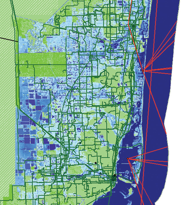
On this map of Miami, blue areas are projected to be underwater by 2118, according to NOAA. Undersea, long-haul and local metro fiber cables are shown, respectively, in red, green and black. Credit: Paul Barford, UW-Madison.
It seems like you can find wireless internet almost anywhere now, but the backbone of the internet is wired: Infrastructure such as fiber optic cables, data centers, traffic exchanges and hubs keeps us connected. In many coastal cities, however, these critical communication pieces are facing increasing risk from rising seas. A new study shows that thousands of kilometers of cables and hundreds of internet traffic hubs will be inundated by rising sea levels in the next 15 years, putting coastal cities like New York, Miami and Seattle at risk for widespread disruptions.
Much of the cable that makes up the physical internet is buried, following existing rights of way such as highways and railroads built along coastlines. “When these networks were first installed around 25 years ago, little thought was given to the impact that climate change and rising sea levels might have on these components,” says Paul Barford, a computer scientist at the University of Wisconsin-Madison and senior author of the new study, which was presented in July at the annual Applied Networking Research Workshop in Montreal.
For the past seven years, Barford and his colleagues have been mapping the physical components of the internet installed and owned by more than 1,500 service providers for a project known as the Internet Atlas. “We now have the largest repository of maps of physical internet infrastructure in the world, which gives us a unique perspective and a unique capacity to study different aspects of the internet’s vulnerabilities,” Barford says. By overlapping their Internet Atlas with sea-level rise projections from NOAA, the team identified 6,545 kilometers of fiber optic conduit and 1,101 nodes that will be underwater in the next 100 years. “The most surprising finding in our analysis is that most of the infrastructure at risk will be underwater in the next 15 years,” Barford says. “The expectation was that we’d have 50 years to plan for this, but we don’t have 50 years.”
Some parts of the physical internet are designed to function underwater, specifically the transoceanic cables that run along the seafloor to connect continents. “Submarine cables are superbly engineered for the marine environment,” Barford says. “They’re also incredibly expensive to make, deploy and maintain.” In contrast, the fiber optic cables that carry communication signals over land typically run through PVC pipes that are merely weather resistant. “Rainwater and groundwater typically don’t penetrate the pipes unless there’s a breach,” he says. But “they aren’t designed to function fully submerged in water.”
The points of the physical internet at greatest risk to seawater inundation are landing points where marine cables connect to standard fiber optic cables, Barford says. “Most landing points are very close to coastlines. Given the projections of seawater inundation, those landing points are likely to be surrounded by [water] or underwater in the very near future,” he says.
Coastal flooding and storm surges associated with hurricanes, like Katrina, Sandy and Harvey, offer glimpses of how rising sea levels may impact internet connectivity, Barford says. “Katrina and Sandy were disasters of epic proportions. It took years to restore service to some of those areas.”
The internet was designed to be resilient, with many redundancies built into the system, says Duane Verner, an urban planner with the Decision and Infrastructure Sciences Division at Argonne National Laboratory in Illinois, who was not involved in the new research. “But there are key hubs, links and nodes in the system that can cause widespread disruptions, perhaps even globally, if they are compromised. This study is an important first step in identifying the most vulnerable components,” he says. It also highlights the rapid onset of the problem. “Sea levels are rising and becoming an issue much faster than anybody thought.”
The next step will be to model the dynamic flow of data through the physical internet to identify which of the vulnerable regions are most crucial for maintaining connectivity. “The clusters of risk that this team has identified should be the starting points for further modeling,” Verner says. “It’s important to identify which ones are truly key and focus mitigation efforts at those connections.”
Mitigating the effects of sea-level rise will take unprecedented cooperation from government agencies, internet providers, and major cities and municipalities. “The internet is a unique animal. It’s not run by any one entity, and no one entity is responsible for maintaining it in the face of climate change,” Barford says. The best strategies for coping with rising seas have yet to be identified, but Barford predicts that solutions will combine various means of infrastructure hardening, such as building sea walls, waterproofing hub buildings, fortifying cables and relocating some networks farther inland, with efforts to streamline existing networks. “The Internet Atlas shows that there’s a huge amount of cable infrastructure in the U.S. One of the things we can do is use existing infrastructure in other areas to reroute the communication traffic,” he says.
“We hope that this study will serve as a call to action on this issue,” he says. “As we see it, we only have about 15 years to make these changes.”
© 2008-2021. All rights reserved. Any copying, redistribution or retransmission of any of the contents of this service without the expressed written permission of the American Geosciences Institute is expressly prohibited. Click here for all copyright requests.