
by Harvey Leifert Monday, December 19, 2016
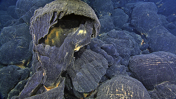
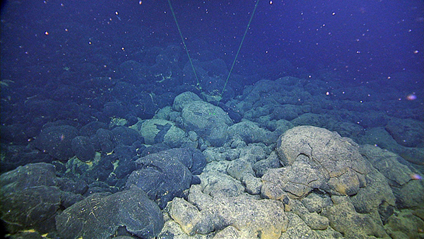
A hollow pillow flow with a frozen tongue of lava spilling from the opening rests atop glass-covered flows that formed during the 2015 eruption. The front of this flow was ~127 m thick. Water depth is 1773 m. Credit: University of Washington/OOI-NSF/CSSF-ROPOS
One of the world’s most active volcanoes has been seen by only a handful of humans — that’s because it lies 470 kilometers offshore of the Oregon-Washington border and about 1.5 kilometers below the surface of the Pacific Ocean. Nevertheless, Axial Seamount on the Juan de Fuca Ridge is one of the best studied of all volcanoes thanks to the Ocean Observatories Initiative (OOI), a global network of seven arrays consisting of more than 800 instruments.
The OOI has provided scientists with unprecedented data about Axial Seamount, the summit of which hosts the network’s one cabled array, and helped them learn about other underwater volcanoes, where most of Earth’s volcanism occurs.
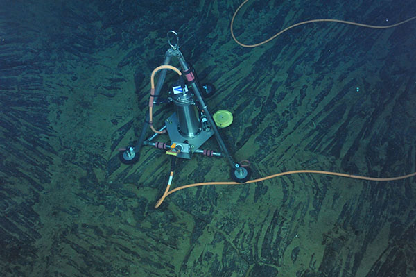
A short-period seismometer on a level triangular metal plate on the seafloor of Axial Seamount that has been plugged into the Ocean Observatory Initiative cabled observatory. Credit: University of Washington/OOI-NSF/CSSF-ROPOS
The cabled array alerted scientists to a massive eruption on April 24, 2015, Axial’s third since 1998. A few months later, oceanographic research cruises to Axial gathered even more data, the results of which were presented Dec. 15 at the American Geophysical Union’s (AGU) fall meeting, and simultaneously published in Science and Geophysical Research Letters.
Axial behaves like a large balloon, expanding and contracting from the buildup and release of magma, said Scott Nooner of the University of North Carolina, Wilmington, at a press conference at the AGU meeting. When it reaches a certain level of inflation, it erupts. During eruptions, the seafloor around Axial suddenly drops about 2.5 meters, then rises slowly over several years, until it reaches a certain threshold.
By monitoring the inflation rate and learning the critical amount of pressure that triggers an eruption, scientists were able to predict the timing of the April eruption, Nooner said. He and co-author William Chadwick of Oregon State University reported their results in Science last week.
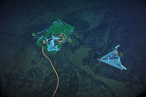
A cabled bottom pressure and tilt instrument installed on the seafloor of Axial Seamount at a water depth of ~1500 m. Credit: OOI-UW VISIONS'14 cruise, UW/NSF-OOI/CSSF
If reinflation of Axial continues at the same pace as at present — about 50 centimeters per year — the next eruption may occur as early as 2019, Nooner said. However, the rate could change, so constant monitoring, which the OOI allows, is essential. As the eruption nears, the researchers’ ability to accurately predict its timing will improve, he added. “That will allow us to sample the lava flows directly after the eruption, which is pretty exciting to be able to do.”
During an eruption, the OOI instruments track the flow of lava along the seabed and help produce maps of those flows. These are complemented by data gleaned during periodic visits to the site by autonomous underwater vehicles (AUV) operated by the Monterey Bay Aquarium Research Institute (MBARI) and the Woods Hole Oceanographic Institution (WHOI). AUVs cruising 50 to 75 meters above the seafloor capture data such as the direction of thin lava flows that are too weak to be detected by sonar from the ocean surface.
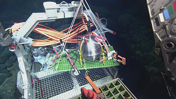
A broadband seismometer (titanium sphere) and hydrophone (tripod) lifted from a tool basket for installation on the seafloor of Axial Seamount at a depth of ~1500 m beneath the oceans' surface. Credit: University of Washington/OOI-NSF/CSSF-ROPOS
Since 2006, MBARI has also explored the area via remotely operated vehicles (ROV), which have contributed to new discoveries. Dives during 2016 revealed new information about the 2015 lava flows, including the presence of previously undetected hydrothermal chimneys, just 30 to 50 centimeters tall, that harbor tube worms and other marine life. These vents were located atop the new lava flows, and were therefore newly formed and colonized, according to David Clague of MBARI, who told EARTH that this was only the second time that such vents had been observed atop new lava deposits.
Current mapping of Axial is possible at one-meter spatial resolution, Clague said, thanks to AUV and ROV surveys in 2015 and 2016. Thirty percent of the area covered by the new flows had been previously mapped, allowing creation of maps showing the difference in the seafloor before and after the eruption. (Bathymetry data were used for areas not previously mapped.)
Black, glass-covered pillow flows (left) from the 2015 eruption of Axial Seamount rest on top of older, lightly sedimented lavas in a water depth of 1,816 meters.
Thirteen separate lava flows were recorded from the 2015 eruption, with flows up to 125 meters deep. Most of those flows were found to the north, whereas, in 2011, the main flow had been to the south. Further, two new eruption styles were observed, said Clague, co-author of the Geophysical Research Letters paper. One type, consisting of a series of explosive eruptions along the fissure zone, created an 8-square-kilometer ash deposit atop Axial’s summit. The other is a noisy steam explosion recorded by seismometers and other instruments, resulting in tens of thousands of tiny craters.
Additionally, the April 2015 eruption produced Axial’s largest volume of erupted lava since mapping began in mid-1980s, after the shortest repose time, Chadwick’s team reported in Geophysical Research Letters. Chadwick, who did not attend the AGU meeting because he is at sea, noted in a statement that Axial is a great natural laboratory because it is close to land, has a simple structure and is frequently active, yet is not a hazard to people. “In some ways, we can learn more about how volcanoes work by studying them underwater,” he wrote, “because the seismic imaging works so much better in the oceans.” Ships can position themselves over a volcano during an eruption and collect data that could not be collected over a land-based eruption.
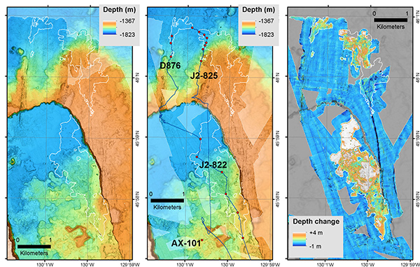
The northern portion of Axial Caldera, as it was mapped by MBARI and Woods Hole autonomous underwater vehicles before (far left) and after (middle) the 2015 eruption. The map at right shows the change in the elevation of the seafloor between these two surveys, indicating the thickness of the lava flows during the 2015 eruption. The areas shown in white are places where the 2015 lava flow is more than 4 meters thick. Credit: ©MBARI
William Wilcock of the University of Washington said another advantage of studying undersea volcanoes is that scientists know exactly where the magma chambers are located because they are not buried as deeply. Ocean crust is typically just 6 kilometers thick, five times thinner than typical crust under land-based volcanoes.
Using seismic data from the 2015 eruption, Wilcock and colleagues measured the orientation of the ring fault that surrounds Axial, the tilting of which directs the flow of lava, they reported in Science.
When Axial next erupts, scientists expect to collect more and better refined data than ever before using new and improved instruments placed on the seamount, the researchers said, including ones that can monitor heretofore unobserved effects of eruptions on the nearby ecosystem.
© 2008-2021. All rights reserved. Any copying, redistribution or retransmission of any of the contents of this service without the expressed written permission of the American Geosciences Institute is expressly prohibited. Click here for all copyright requests.