
by Lauren Milideo Friday, October 12, 2018
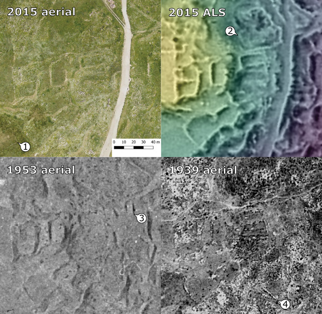
Researchers used different datasets to uncover Jerash's past, because each dataset showed something different. 1) High-resolution photography revealed a stone wall not visible in other datasets. 2) Lidar clearly revealed another wall that was poorly defined in aerial photography. 3) Clearing up distortions in this 1953 photo revealed a possible structure defined by highlight and shadow that was obscured by a modern road in 2015 and by vegetation in 1939. 4) This wall from the 1939 aerial photo was not visible in other datasets. Credit: Danish-German North-West Quarter Project.
People have inhabited Jerash, Jordan, since the Neolithic. But much of its history has been buried by subsequent occupation, including over the last two centuries. Archaeologists have excavated Jerash with trowels and screens to uncover its long history, but now, with the help of lidar and old photographs, a team of researchers is discovering more about Jerash’s past by gazing down on the city from the sky.
Previous studies focused on monuments rather than sites associated with everyday life, so “we know nothing about what went on in the part of the city where people actually lived,” says Rubina Raja, a classical archaeologist at Aarhus University in Denmark and a co-author of the new study in Proceedings of the National Academy of Sciences. The team wanted to study the unknown areas using approaches less intrusive than excavation, says lead author David Stott, also an archaeologist at Aarhus.
The team collected a series of 10 historical aerial photographs over Jerash from 1917 to 1953 from various sources, and a 2015 lidar image of the city from the Royal Jordanian Geographic Center. The photographs were processed to remove geographical distortions typical in old aerial photographs taken from various angles, Stott says, so the team could confidently compare the same locations at different times. After comparing the historical images, the team used GIS software to analyze the lidar image, revealing subtle topographic changes that potentially indicated archaeological remains, he says.
The researchers then created maps showing possible locations of former roads, walls and other infrastructure, including those that had disappeared at some point. These maps provided a means to observe the city’s changing landscape over the past century, particularly where archaeological remains had been lost to recent development.
“In a place like Jerash, if we only use modern data, there’s a lot of stuff we don’t see,” Stott says. It’s important to see features in their original context, especially large features like aqueducts and roads, he says. “We still have bits of [these large features] left in the present. But without being able to see the whole [urban] system, they don’t mean very much, and that’s really what the archival imagery and the deep-time perspective add to this work.”
Combining remote-sensing data with old aerial photos is a key contribution of this work, says John Weishampel, an environmental scientist at the University of Central Florida who specializes in remote sensing but was not involved in the study. “Those older datasets allow you to have a more complete picture of the entire city area” and the activities occurring in and around the urban center, Weishampel says.
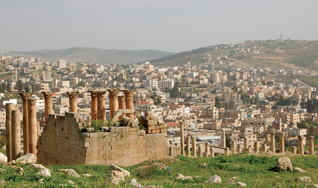
The ancient city of Jerash is juxtaposed with the modern one. Credit: Danish-German North-West Quarter Project.
Some features identified in the work, like cisterns and channels, were known, but the researchers also documented previously undiscovered elements of the city’s ancient water management system, such as a potential aqueduct and potential reservoirs. “Water management, in antiquity, and even today, in these semi-arid areas … means everything for survival,” Raja says. “If we can get to the heart of how water was managed over centuries or millennia, we might actually crack the code to the resilience threshold for urban societies over time.”
This has modern implications, Raja notes. “When are you overexploiting your resources, and when does the balance tip so that urban societies disappear? Looking at that in a historical perspective might give us some new thoughts on what we can do for modern situations.”
Next, the team plans to investigate the area around Jerash and keep probing the city’s ancient water management, Stott says. Many previous excavation reports remain unpublished, so the researchers want to explore excavated areas they identified on their maps. Indeed, the need for careful documentation and sharing of archaeological data is another important lesson of this study, Raja says.
The research may also prove useful for identifying where archaeological remains in other areas are threatened by modern development or conflict, Weishampel says.
© 2008-2021. All rights reserved. Any copying, redistribution or retransmission of any of the contents of this service without the expressed written permission of the American Geosciences Institute is expressly prohibited. Click here for all copyright requests.