
by Terri Cook and Lon Abbott Wednesday, July 13, 2016
Zermatt, Switzerland, is one of Europe’s premier tourist destinations, offering spectacular sightseeing, hiking and mountain climbing, as well as year-round skiing. The area’s popularity is rooted in its geology. Its high-grade metamorphic rocks and massive folds vividly narrate the story of the Alps’ formation, from the peregrinations of microcontinents during the breakup of Pangea to their assembly during the mighty Alpine Orogeny, the tectonic collision that raised the impressive mountain chain 40 million to 50 million years ago. More recently, massive glaciers sculpted this highland into today’s jagged peaks and deep valleys to create iconic glacial landscapes. Yet Zermatt’s scenic climax, one of the world’s most famous mountains — the Matterhorn — isn’t European at all; it was hewn from a slice of Africa.
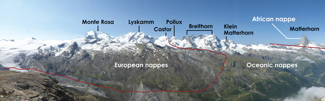
Glacial erosion revealed a stack of thrust-bounded rock sheets called nappes. From bottom to top, this stack consists of the nappe containing the native European rocks of the Briançonnais microcontinent, followed by the oceanic nappe that marks the suture between Europe and Africa, and at the top of the heap, the ancient crust that was once part of Africa. Credit: Terri Cook and Lon Abbott.
“The story of Switzerland’s Alps began about 165 million years ago, during the breakup of the supercontinent Pangea. At that time, Africa began pulling away from Europe, opening up the diminutive Piemont Ocean between Africa’s bulk and the Briançonnais microcontinent, which lay just off the European mainland. This ocean was short-lived; it began closing again about 100 million years ago, when Earth’s plate motions shifted and the North Atlantic Ocean was opening.
Closure of the Piemont Ocean occurred as its oceanic lithosphere subducted beneath Apulia, which during that time was a peninsula connected to North Africa. As the ocean shrank, Europe and the Briançonnais microcontinent drew ever closer to Apulia. Fifty million years ago, the Briançonnais microcontinent was then stuffed under Apulia, transforming the subduction zone into the Alpine continental collision zone. A sliver of the Piemont Ocean floor was thrust atop the microcontinent, and the Apulian portion of Africa was, in turn, stacked atop the oceanic material, forming the Alpine highland.
The rocks were so contorted during this thrusting that some of them were flipped upside down, forming recumbent folds. Glacial erosion during the Pleistocene ice ages later carved this highland into today’s rugged, high-relief Alps, in the process revealing a stack of thrust-bounded rock sheets called nappes. From bottom to top, this stack consists of the nappe containing the native European rocks of the Briançonnais microcontinent, followed by the oceanic nappe that marks the suture between Europe and Africa, and at the top of the heap, the ancient crust that was once part of Africa.
Zermatt, Switzerland, is one of Europe's premier tourist destinations, offering spectacular sightseeing, hiking and mountain climbing, as well as year-round skiing. The area's popularity is rooted in its geology, which is best explored on foot. Credit: both: K. Cantner, AGI.
“One of the best ways to explore Zermatt’s stunning scenery is by hiking through it. A great introduction to the area is to head to the 3,100-meter-high Rothorn, high on the ridge east of Zermatt. This is an ideal place to orient yourself to the area’s tectonic history, as well as soak up the most coveted of all Matterhorn vistas: the peak reflected in the glassy surface of the small Stellisee Lake.
From the perch atop the Rothorn, the panorama of rugged, glaciated peaks is breathtaking in all directions, and it’s easy to see three nappes involved in the Alpine collision. Looking south, the massive mountain on the left is Monte Rosa, the Alps’ second-highest peak at 4,634 meters. To the right lies the equally bulky Lyskamm, followed by the twin peaks of Castor and Pollux. The granite and gneiss that comprise the mountains from Monte Rosa to Castor are native to Europe, part of the Briançonnais microcontinent. Pollux and — farther right — the Breithorn and Klein (Small) Matterhorn, are all made of rock that formed on the floor of the ancient Piemont Ocean. Still farther right stands, in splendid isolation, the stunning 4,478-meter-high Matterhorn, whose rocks belong not to Europe, but to the Apulian part of Africa.
All three of the nappes visible here have been through the tectonic wringer, but it’s the European rocks at the base of the stack that have experienced the most upheaval. Within 10 million years of the collision’s onset, the European rocks were buried at least 45 kilometers beneath the oceanic material and the African rocks. Such deep burial subjected this slice of Europe to ultrahigh pressures, which metamorphosed them to the highest metamorphic grade, known as eclogite facies metamorphism. But because this nappe is composed of continental crust, it has relatively low density and hence is too buoyant to have remained at such depths for long. Like a bubble in the bottom of a lava lamp, this rock buoyantly rebounded and, in the process, raised the overlying oceanic rocks and African crust stacked above them.
The rocks at the Rothorn also belong to the oceanic nappe. To examine them, hike the well-marked Abenteurweg and Panoramaweg trails down to Blauherd. From there, the Stellisee’s iconic Matterhorn view is a 15-minute stroll through gentle meadows. More ambitious walkers can examine direct evidence of the rocks’ oceanic origin on a five-hour hike to the town of Täsch via the rugged Pfulwe Pass. Basalt that erupted underwater possesses a distinctive pillow-shaped texture, which is evident in the rocks near the pass. The Mellichen Valley, which you encounter as you descend from the pass, sports rocks containing sheeted basaltic dikes, another telltale sign of the rock’s origin as oceanic crust.
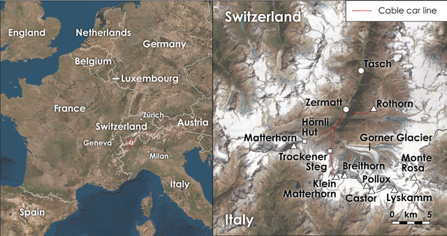
Another iconic Zermatt experience is to ride the historic Gornergrat cog railway, which made its first ascent to the top of the 3,089-meter-high Gornergrat on Aug. 20, 1898. From the vantage point at the railway station, you’re treated to stunning views of the 60-square-kilometer Gorner Glacier, Europe’s second largest, which occupies the deep valley between the ridge of the Gornergrat and the mountain wall between Monte Rosa and Breithorn.
“During the Pleistocene, glaciers like the Gorner masterfully sculpted the broad upland produced by plate collision into the soaring, steep-walled peaks and precipitous, U-shaped gorges that compose today’s dramatic landscape. Today, the Gorner Glacier is 450 meters thick where it joins the Grenz Glacier, its main tributary, at the foot of Monte Rosa. During the peak of the Pleistocene ice ages, however, the Gorner Glacier was but one tributary of a much larger glacier that was more than a thousand meters thick and that carved out the Zermatt Valley.
Gazing down at the glacier, you can see that the lateral moraines — the piles of unstable, glacially quarried rock debris that line the glacier flanks — tower 150 meters above the ice surface. This is because the Gorner Glacier has shrunk vertically by 150 meters since 1931. Every spring, a lake fed by melting snow forms at the confluence of the Gorner and Grenz glaciers. When the lake becomes deep enough, it floats the glacier ice off its bed, triggering a subglacial outburst flood. Several such floods during the early 20th century had discharges greater than 100 cubic meters per second, large enough to cause extensive damage in the Zermatt Valley. More recent floods have been smaller, just 20 to 50 cubic meters per second, and, as the temperature has warmed, the date of the annual flood has advanced to earlier in the year. In 1950, the annual flood typically occurred in August; now the flood usually occurs in late June.
“If you make only one mechanized ascent into the mountains surrounding Zermatt, it should be to ride Europe’s highest cable car to just below the 3,883-meter summit of the Klein Matterhorn, a comparatively small spire that stands between the Breithorn and the Matterhorn. After you disembark from the tram, you gain an unusual perspective on the oceanic nappe while traversing a tunnel bored through green rock riddled with white veins — battle scars from the rock’s tortuous tectonic history. The tunnel continues through the glacial ice, giving you an excellent glimpse of its annual layers. The tunnel deposits you at the café, where you can grab an overpriced snack or take an elevator down to Glacier Paradise, a maze of tunnels adorned with intricate ice sculptures carved 15 meters beneath the glacier’s surface. Be sure to also take the lift up to the observation deck, where the panorama stretches from Italy’s dusty Po River Valley to the south, past the Matterhorn, to the distinctly U-shaped Zermatt Valley to the north.
“Even in summer, some of your fellow cable-car passengers will likely be toting skis, and some may well be members of national ski teams that use the area for summer training. Other passengers will have ice axes, crampons and ropes strapped to their packs, as a departure from the Klein Matterhorn offers climbers quick ascents of some classic alpine routes. The presence of the cable car makes the nearby Breithorn, at 4,164 meters, the easiest and most-climbed of the 82 mountains in the Alps that exceed 4,000 meters. For experienced mountaineers, it is an easy two- to three-hour ascent up 35-degree snow slopes. It also makes a wonderful introduction to alpine climbing for novice mountaineers, as the experienced guides at the Zermatt Alpin Center can safely lead any fit person equipped with crampons and a harness past a couple of crevasses and the airy summit ridge to the top of the impressive peak.
“Much less taxing than an ascent of the Breithorn is the Matterhorn Glacier Trail. It’s a delightful wander through mangled oceanic crust recently exposed by the retreat of the Theodul and Furgg glaciers, with the Matterhorn looming above you the entire way. Start your hike at Trockener Steg, the base station for the highest of the three cable cars that link Zermatt to the Klein Matterhorn. The hike ends at Schwarzsee, a small pond at the top of the cable car that provides access to the standard Matterhorn climbing route. Geology buffs will especially like the interpretive signs describing the various oceanic rocks you pass en route, including dense, garnet-bearing eclogite and green serpentinite, the result of water being incorporated into the crystal structures of mantle and oceanic crustal rocks during metamorphism.
“If you’re up for a more rigorous hike, consider making the 680-meter ascent from Schwarzsee to the Hörnli Hut, the hut from which Matterhorn climbers make a midnight departure on their ascent day. The hike to the hut is well marked, as are most if not all Zermatt trails, but it is steep and has some exposed sections along which ladders and ropes have been added for safety. The hut is perched on green rocks that belong to the oceanic nappe, whereas the steep mountain walls immediately above the hut consist of brown-hued African rocks. The Matterhorn is the archetypal glacial horn, a rugged peak left standing high above its surroundings by the scouring action of multiple glaciers that flowed in different directions from its summit, like the spokes of a wheel. Four different glaciers carved the Matterhorn, three of them tributaries of the mighty Zmutt Glacier that excavated the Zermatt Valley and a fourth that flowed south into what is now Italy.
“Most visitors spend few daylight hours in Zermatt itself, choosing instead to maximize their time hiking, biking, skiing, climbing and paragliding. But the village provides a pleasant base, offering comfortable lodging, plenty of shopping, and a good selection of restaurants. While in town, be sure to walk through “Old Zermatt,” a cluster of 30 traditional buildings constructed on stilts. Slate slabs are inserted part way up the stilts to block rats from scurrying up them into the houses.
© 2008-2021. All rights reserved. Any copying, redistribution or retransmission of any of the contents of this service without the expressed written permission of the American Geosciences Institute is expressly prohibited. Click here for all copyright requests.