
by Terri Cook Friday, August 29, 2014
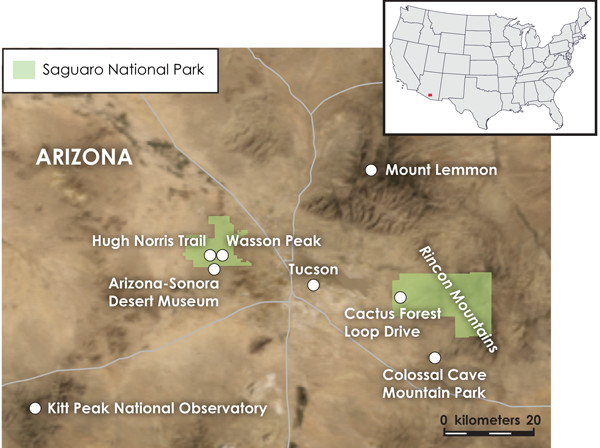
Late last March, seeking warm sun and a verdant landscape after a cold, snowy Colorado winter, our family headed south during the spring school break to the lowest-elevation place we could easily drive to in a day or two: Tucson. Hosting Saguaro National Park, the Arizona-Sonora Desert Museum and the largest concentration of astronomical observatories in the country, Tucson has the grand vistas, great hikes and learning opportunities we wanted.
There is a good reason “snowbirds” flock to southern Arizona each winter: It’s warm. And there are two main reasons for this warmth. Most obviously, the sun is intense this far south in the American West. A less obvious, but equally important, reason for the region’s winter warmth is that about 30 million years ago, southern Arizona’s crust began to stretch, lowering its elevation in the process. The stretching was a byproduct of the clash of tectonic plates off the coast of California that formed the San Andreas Fault. The rocks and the scenery of the Tucson area record that tectonic battle, including the demise of an entire plate.
Credit: Kathleen Cantner, AGI.
Most Americans are familiar with California’s San Andreas Fault, where the Pacific Plate grinds against the North American Plate and occasionally unleashes hazardous earthquakes with each sizable lurch. Less well known is that, prior to 30 million years ago, a different piece of crust — the Farallon Plate — butted up against North America’s west coast.
Instead of sliding past its North American counterpart, however, the Farallon Plate crashed headlong into it. Because the Farallon Plate consisted of more dense, oceanic crust, it subducted beneath North America, triggering mantle melting and producing pools of magma all along North America’s west coast. Those magma pools fed a chain of volcanoes reminiscent of the modern Andes that stretched from British Columbia, through California and Arizona, to Mexico. The associated compression squeezed Nevada and Arizona, uplifting them to create a high plateau that, in recognition of its likely resemblance to South America’s modern Altiplano, geologists commonly call the Nevadaplano.
About 30 million years ago, however, conditions on the Nevadaplano changed dramatically when the spreading center separating the Farallon and Pacific plates began entering this subduction zone. For the first time ever, the Pacific Plate touched North America, compression ceased and the San Andreas strike-slip fault was born.
The end of subduction also meant the end of the compression that had previously propped up the southern portion of the Nevadaplano. The crust here began to stretch like an accordion and the plateau collapsed, creating the linear basins and ranges of the Mojave and Sonora deserts. As time went on, subduction consumed more and more of the Farallon Plate, swallowing it from south to north. As a consequence, the San Andreas Fault grew northward, eventually also causing the northern portion of the Nevadaplano to collapse, shaping Nevada’s distinctive Basin-and-Range topography. Because crustal stretching has been happening for longer in southern Arizona, it sits at a lower elevation. And this is part of the reason it has much warmer winters — and many more snowbirds — than Nevada.
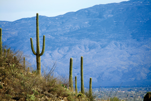
The Saguaro cactus (Carnegiea gigantea) is an iconic emblem of the American West. Despite this broad association, saguaro are actually geographically limited to the Sonoran Desert of Arizona and adjacent Sonora, Mexico, and are only found below about 1,200 meters elevation.
In 1933, two of the best forests of these large, tree-sized cacti, one east of Tucson and one to the west, were set aside as Saguaro National Monument. In 1994, Congress upgraded their protection by designating the land as Saguaro National Park. The western unit straddles the Tucson Mountains, the rocks of which were forged about 70 million years ago in a volcanic caldera fed by magma produced as the Farallon Plate subducted.
The Tucson Mountains’ dark volcanic rock is a mixture of ash-flow tuff and megabreccia. The tuff was produced by the hot-welding of 400 cubic kilometers of ash that the volcano expelled in a mighty belch. This rapid emptying of the magma chamber caused the overlying volcano to collapse; the megabreccia comprises the resulting jumble of angular blocks, some the size of cars, created by that collapse.
A short hike on the park’s Hugh Norris Trail takes you across the remains of that caldera and into a dense saguaro forest. If you want a longer excursion, the trail continues 8 kilometers to the 1,428-meter-high summit of craggy Wasson Peak, the highest in the Tucson Mountains. In spring, the park’s desert floor is covered with white, yellow, red, and purple wildflower blossoms, which offer an eye-pleasing contrast to the green saguaro, the brilliant blue sky, and the ruddy volcanic rocks. The saguaro cactus blooms from late May to July, producing a white, waxy blossom that is the Arizona state flower and a favorite treat for the many animals that call this area home.
Just south of the national park boundary, also in the Tucson Mountains, is the Arizona-Sonora Desert Museum. It is regularly listed as one of the top zoological parks in the world thanks to its emphasis on tracing the complete natural history of the Sonoran Desert and adjacent ecosystems. You can learn, for instance, about the 250-year lifespan of the Saguaro cactus and its ecological relationships with the many other plants and the animals that make the Sonoran Desert one of the lushest deserts on Earth.
The museum is linked to Tucson by Gates Pass Road, which crests the Tucson Mountains at the eponymous Gates Pass. The scenic view from Gates Pass looks down into the Tucson Valley below. Here a roadcut reveals layered sedimentary rocks that seem out of place amid the dark ash-flow tuff. They really are out of place; they comprise a gigantic block of megabreccia produced by the caldera’s collapse.
Once the Farallon Plate was consumed, the magma that had fed subduction zone volcanoes, like the one that formed the rocks of the Tucson Mountains, dried up and the volcanoes went extinct. The subsequent collapse of the Nevadaplano, on which these volcanoes sat, was accomplished along normal faults, which drop rocks on one side of the fault down relative to the other. One such steeply angled normal fault lies between Gates Pass and Tucson, hence, the down-dropped Tucson Valley to the east.
The whaleback shape of the Santa Catalina and the Rincon mountains is characteristic of metamorphic core complexes. Credit: ©Shutterstock.com/Andy Magee.
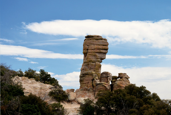
A hoodoo on Mount Lemmon Highway composed of mylonitic gneiss of the Catalina metamorphic core complex. Credit: ©Shutterstock.com/AHPix.
Saguaro National Park’s much larger eastern unit protects another magnificent saguaro forest and is also carpeted with wildflowers each spring, but this is where the similarities end. The eastern unit straddles the Rincon Mountains, a broad dome whose rounded shape resembles the back of a breaching whale — a profile very different from the Tucson Mountains’ long, narrow range of craggy peaks. Most park visitors tour the eastern unit’s saguaro forest along the paved, 13-kilometer-long Cactus Forest Loop Drive; few venture into the remote backcountry, where mountain ridges, which top 2,642 meters, are too high to support saguaros.
The Rincon area’s whaleback shape, which can be seen to the east along the loop drive, is due to its formation as a metamorphic core complex — a dome of metamorphic and intrusive igneous rocks bounded by the shallow-dipping Santa Catalina Fault. Prior to the 1960s, geologists were convinced that the Santa Catalina was a thrust fault, a low-angle fault caused by compression that raises rocks on one side relative to the other. This was the only type of low-angle fault known at that time. Eventually, careful research in Tucson’s Rincon and Catalina mountains helped geologists recognize the Santa Catalina Fault as an example of a new type of low-angle extension, called detachment faulting. During this type of faulting, the rocks above the gently inclined fault slide off, exposing the underlying rocks and typically displacing the overlying rocks long distances — tens of kilometers — laterally.
Unless you have time for a long wilderness hike, the Rincon metamorphic core complex can only be seen from afar. But a grand tour through the mylonitic (stretched) gneiss of the Catalina core complex can be had on the spectacular drive up Mount Lemmon, on Tucson’s northeastern edge. The roadside stop at Windy Point is a particularly good place to see this rock, which usually has several rock climbers clinging to its tiny ledges.
In the hills to the south of the Rincon Mountains lies Colossal Cave, a limestone cavern listed on the National Register of Historic Places. The cave had already been used for centuries by prehistoric peoples when it was “discovered” in 1879. Since then, the cave has seen thousands of visitors, from train robbers to snowbirds. The first cave tours, which involved ropes and lanterns, occurred in 1923. Today’s tours are much more comfortable thanks to the Civilian Conservation Corps, which installed buildings, walkways and wiring in the mid-1930s. Colossal claims to be the biggest “dry” cave in the world, meaning that its stalactites, stalagmites and other decorations, which were slowly deposited by dripping groundwater, are no longer growing.
Like most caves, Colossal Cave is etched into limestone, in this case marine limestone deposited 340 million years ago during the Carboniferous Period. At the cave’s entrance, you can see that the layers are tilted steeply down to the south. This is because the surrounding hills consist of rock that slid off the top of the Rincon Mountain metamorphic core complex during movement on the Santa Catalina detachment fault. The rocks rotated as they slid, tilting into their present configuration.
Tucson’s rocks thus tell the story of the collapse of the Nevadaplano plateau, which occurred because the end of Farallon Plate subduction meant the end of compression. That compression had heretofore propped up the plateau, much like a belt holds up a pair of baggy pants; once the belt is removed, the pants fall down. The first stage of Nevadaplano collapse occurred via detachment faulting, followed by a later generation of steeper normal faults. This later generation of faults now bounds the Tucson Mountains and the other narrow, craggy ranges of the Basin-and-Range Province. It was this plateau collapse and, indirectly, the birth of the San Andreas Fault, that today inspires snow-weary travelers seeking sun, saguaros and stars.
© 2008-2021. All rights reserved. Any copying, redistribution or retransmission of any of the contents of this service without the expressed written permission of the American Geosciences Institute is expressly prohibited. Click here for all copyright requests.