
by Laurie J. Schmidt Friday, June 1, 2018
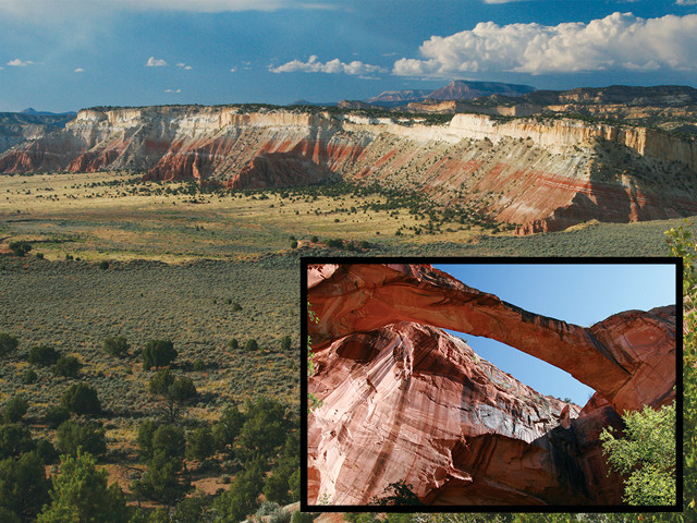
Above: The elevated Kaiparowits Plateau extends more than 80 kilometers from the town of Escalante, Utah, to the Arizona border. Below: A self-guided trail leads upstream on the Escalante River to Escalante Natural Bridge. Credit: ©Laurie J. Schmidt
It’s no secret that the American Southwest harbors some of the most dramatic geology in the world. Although many visitors stick to the Grand Canyon, Bryce Canyon and Zion National Parks, geology-savvy travelers will also want to head to an often-overlooked region with relatively easy access to unique rock formations, fossils and cultural artifacts: the Grand Staircase-Escalante National Monument.
Occupying close to 8,100 square kilometers in southern Utah, the monument is one of the planet’s premiere locations for viewing erosion-carved features such as arches, natural bridges, slot canyons and hoodoo rock formations — tall, thin spires created through differential erosion, often of softer rock underlying a resistant capstone.
Established in 1996 by President Bill Clinton, the monument is divided into three sections defined by distinct topography. The Grand Staircase features a stair-like series of cliffs and terraces that extends about 240 kilometers from the North Rim of the Grand Canyon in Arizona to southern Utah. The Kaiparowits Basin section is characterized by a large plateau known for its Late Cretaceous-aged fossils, and the Escalante Canyons section is a maze of steep canyons sculpted by the Escalante River.
About 60 million years ago, much of southern Utah was covered by lakes. Over time, the lake sediment hardened, and when the Colorado Plateau began uplifting, the layers of lithified sediment were exposed, creating the staircase.
The Monument’s All-American Road
The main transportation corridor through the monument is Utah Scenic Byway 12, a designated All-American Road that begins just east of Bryce Canyon National Park in southern Utah and continues north for 200 kilometers over Boulder Mountain to the town of Torrey. The section between the towns of Escalante and Boulder is considered one of the most scenic stretches of highway in the United States. Just before the town of Boulder, the road’s famous “hogback” passes precariously over a razor-thin section of slickrock (the Southwestern term for large swaths of sandstone). The terrain drops steeply down each side of the road, providing vistas of the canyons and cottonwood-lined creeks below.
One of these creeks, Calf Creek, has carved a deep canyon in the Navajo Sandstone and Kayenta Formation, creating Lower Calf Creek Falls, one of the most scenic oases in the western U.S. From Calf Creek Recreation Area, you can hike 10 kilometers through the canyon to the 38-meter waterfall, which plunges into a large pool enclosed on three sides by sandstone walls. Green algae and hanging gardens on the sandstone walls make for colorful photos. The trail offers various access points to the creek where you can cool off in the clear, shallow waters. Points of interest along the self-guiding trail include a panel of ancient pictographs high on the sandstone walls across the canyon.
Along Byway 12, several overlooks provide vistas of the area’s vast redrock canyons. From Head of the Rocks Overlook, just east of Escalante, expansive views reveal the ancient sand dunes that now exist as colorful slickrock. Just west of Calf Creek Recreation Area, the Boynton Overlook provides a good introduction to the Escalante River Gorge. With nothing but redrock canyons surrounding you, it is probably the last place you would expect to find a coffee shop. But just around the corner from the Boynton Overlook is the Kiva Koffeehouse, a circular structure modeled after a kiva, or ceremonial chamber. It’s a great place to sip a latte while taking in the views offered by the kiva’s large picture windows.
Exploring the Escalante Canyons
Many of the monument’s unique formations owe their existence to two major tributaries of the Colorado River. To the east, the Paria River includes Buckskin Gulch, the longest slot canyon in the United States. To the west, the Escalante River flows for 145 kilometers from near the town of Escalante to Lake Powell in Glen Canyon Recreation Area. On its way to the Colorado, the Escalante cuts through the lower Morrison, Dakota and Entrada Sandstone Formations, which were deposited as the region fluctuated between marine, lake and desert environments.
Where Byway 12 crosses the Escalante River, a small parking area on the upstream side provides access to the Escalante River Trail, where you can hike about four kilometers to the impressive Escalante Natural Bridge perched high above the river. With a span of 38 meters, the bridge is the largest sandstone span in the monument. On your way to the bridge, you will wade across the river several times, which makes the journey as much fun as the destination. Typically, crossing the river is easy — like walking across a shallow swimming pool. However, be aware that during spring runoff, the Escalante can become a raging torrent. The first crossing at the start of the trail is best done with a hiking stick for balance, due to the unstable rocky bottom.
Along the Escalante River’s sinuous journey to Lake Powell, the river has spawned a maze of steep, narrow canyons — a wonderland for hikers and canyoneers. Slot canyons begin as mere cracks in sandstone; over time, repeated flooding sends water rushing through the cracks, making them deeper and wider.
About eight kilometers east of the town of Escalante on Byway 12 is the turnoff for Hole in the Rock Road, a dirt and gravel road that leads 90 kilometers (some of it rough) to Lake Powell. This road offers access to two of the area’s most popular slot canyon day hikes — Spooky Gulch and Peek-a-boo Gulch. During summer monsoons, floodwaters laden with sediment fill the canyons and scour out potholes, which create obstacles to climb over and under as you make your way through the canyons. The canyons can be reached by driving about 40 kilometers down Hole in the Rock Road to the Dry Fork parking area, where a trail leads down to the canyon entrances. Be warned: these canyons are not for the claustrophobic. The entrance to Spooky Gulch is wide, but it narrows considerably and you will have to squeeze through sideways in some spots.
Another must-see stop along Hole in the Rock Road is the Devils Garden, located off a short spur road about 20 kilometers from Byway 12. Here, erosion has sculpted the Entrada Sandstone into a playground of fantastic spires, arches and hoodoos. The best-known feature is Metate Arch, a uniquely shaped natural arch that makes for great photos. The lighting just before sunset makes the otherworldly shapes and formations in the Devils Garden glow.
The Road Less Traveled: Cottonwood Canyon Road
Whereas Scenic Byway 12 will give you more dramatic scenery than you could hope for, another more adventurous way to see some of the monument’s geologic features is to take the unpaved Cottonwood Canyon Road, which runs 75 kilometers from U.S. Route 89 in northern Arizona and connects with Byway 12 at Cannonville, Utah. The road can usually be driven in a car (washboard conditions in some sections are common), but recent rains can make the road impassable even to all-wheel-drive vehicles. Be sure to stop at the Bureau of Land Management (BLM) office in Cannonville (north end) or Big Water (south end) to ask about current road and weather conditions. Nothing ruins a trip faster than a stuck vehicle and an $800 towing bill. Given the area’s remoteness, carry plenty of water and extra food too.
The Cottonwood Canyon Road parallels the Cockscomb, a wall of steeply inclined layers of colorful, striped rocks that make up part of the East Kaibab Monocline — a large-scale fold that begins near the Grand Canyon. The most scenic section is in Cottonwood Narrows, where colorful, jagged Navajo Sandstone pinnacles line the road.
About eight kilometers north of the Narrows, a short spur road leads to Grosvenor Arch, a rare sandstone double arch. At 46 meters high with a span of 28 meters, the arch looks like a grand cathedral in the middle of the desert. Do not be surprised if you spend more time here than you planned — short trails allow you to view and photograph the arch from a variety of angles that give completely different perspectives.
The Cottonwood Road hits pavement again about 20 kilometers north of Grosvenor Arch, and here you can turn right to take a detour to Utah’s Kodachrome Basin State Park. The park got its name when the area was photographed by National Geographic in 1949; they named the area after the relatively new line of Kodak film they used. This park is known for its rock spires and chimney formations, called sand pipes, thought to be the solidified sediment that once filled ancient springs or geysers. The park has a scenic campground set among the rock formations, as well as several hiking trails.
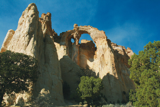
Grosvenor Arch is a double sandstone arch within the Grand Staircase-Escalante National Monument. Credit: ©Laurie J. Schmidt
If you are traveling to or from northern Arizona and wish to bypass Bryce and Zion national parks, taking the Cottonwood Canyon Road trims about 135 kilometers off your driving distance. The road can be driven in two to three hours, but if you want to do any exploring, allow at least half a day.
Aside from its spectacular geologic features, the monument is also a treasure trove of fossils and ancient cultural artifacts. Many paleontologists who have done fieldwork there consider the Grand Staircase-Escalante region to be the richest source of dinosaur fossils in the world. In 2007, the Utah Geological Survey announced the discovery of the skull of a new species of duckbill dinosaur, as well as the fossils of two horned dinosaurs. The BLM office and visitor center in Big Water, Utah, has a fascinating display of dinosaur fossils and a 9-meter mural that depicts the Late Cretaceous period.
You can also find pictographs (paintings and drawings) and petroglyphs (carvings) on the sandstone canyon walls, particularly along the Upper Escalante River. Inquire at one of the BLM visitor centers for precise locations, as these are not typically marked along trails due to vandalism problems.
The region encompassed by Grand Staircase-Escalante National Monument was reportedly the last area in the lower 48 states to be mapped — testament to its remote and rugged character. Whether it is your main destination or a stop en route to the region’s other national parks, a visit to Utah’s newest national monument is an experience in true desert wilderness.
© 2008-2021. All rights reserved. Any copying, redistribution or retransmission of any of the contents of this service without the expressed written permission of the American Geosciences Institute is expressly prohibited. Click here for all copyright requests.