
by David B. Williams Tuesday, June 5, 2018
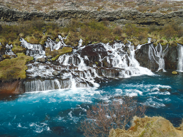
With plentiful precipitation and glacial meltwater, Iceland is famous for its abundance of waterfalls, including Hraunfossar. Credit: David B. Williams
On a recent trip to Iceland, my wife and I learned a central fact of life while traveling around this isolated island country: We could never escape the geology. We quickly learned to be wary of hot water taps because the water — sourced directly from geothermal hot springs — came out at scalding temperatures. At a hostel in the small town of Laugarvatn, we more comfortably exploited this phenomenon by soaking in a hot pot — similar to one built by one of Iceland’s most famous early citizens, the 12th-century writer Snorri Sturluson, which you can still visit. We also ate delicious tomatoes grown in greenhouses heated by Iceland’s largest thermal spring, which gushes 180 liters of boiling water every second.
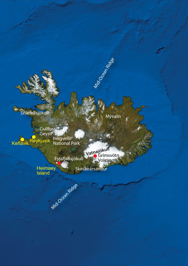
Credit: AGI/NASA
Of course, the main geology we couldn’t escape was the volcanoes. We had planned a side trip to Scotland for a few days in the middle of our Icelandic vacation, but an unexpected eruption of Grimsvötn volcano stopped us and trapped us in Iceland. Although we were disappointed not to be able to visit Scotland, we accepted our fate and instead spent a few more days exploring Iceland’s amazing landscape. Whether the geology traps you or you intend to stay for a while in Iceland, there is more than enough dramatic geology to entertain anyone.
We based ourselves 45 kilometers from Vatnajökull National Park at a youth hostel in Hvoll for the first part of the trip. Early on our second day, we drove on the south coast toward the Skaftafell region of the park — a location that used to be its own national park but was merged with another to form Vatnajökull in 2008. We saw no cars for the first half hour of our trip and, thankfully, none while crossing the eerie Skei∂arársandur, a 1,300-square-kilometer glacial outwash plain of gravel, sand and pebbles, although we saw several Arctic foxes. I hesitate to use the word “drove” because it felt more as if we were blown down the road, which snakes across the plain on a berm. The wind whipped up and over the berm and carried so much sediment that it formed a visible wave of rocky dust. The only decent visibility was on the single-lane bridges that cross the several rivers flowing out of the 20-kilometer-wide glacier called Skei∂arárjökull. (Jökull, meaning glacier, is a common geographic suffix you will see on Icelandic maps, along with vötn (lake), fell (mountain), and foss (waterfall).)
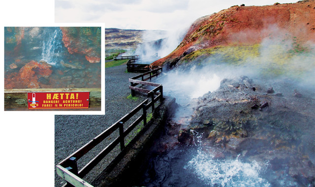
Deildartunguhver, Iceland's largest hot spring, produces 180 liters of boiling water per second. Deildartunguhver, Iceland's largest hot spring, produces 180 liters of boiling water per second. Credit: Bottom: Jón Sævar Hallvarðss/Creative Commons Attribution-NoDerivs 3.0 Unported; inset: David B. Williams
When we finally emerged out of the wind, we stopped along the road next to a massive steel bridge support that had been bent like a pretzel during the 1996 eruption of Grimsvötn. Heat from the volcano had melted the overlying glacier, and the surging water lifted the volcano’s icy cap creating a jökulhlaup, or glacial outburst flood. The estimated flow of the jökulhlaup was 53,000 cubic meters per second. Only one river on Earth has a greater average flow — the Amazon — with a discharge of about 180,000 cubic meters per second. (Seven weeks after our visit, another jökulhlaup destroyed a bridge below Mýrdalsjökull, about 100 kilometers west of the Skei∂arársandur.)
On our third day in Iceland, the sun appeared and we decided to take the ferry from Landeyjahöfn to explore the island of Heimaey. As we reached the harbor, we could see the black basalt cliffs rising out of the water. Heimaey was made famous by a 1973 eruption that added nearly 2 square kilometers of land to the island and nearly destroyed the island’s eponymous lone town. The edge of the resulting basalt flow is found right in town, rising from the site where it finally stopped after swallowing more than 120 homes. Plants have started to colonize the lower reaches of the flow, including beautiful patches of lupines, which appear especially blue against the black rock. Climbing higher up the flow, we skirted the town dump, conveniently hidden by a ridge of basalt, and reached the cinder cone of Eldfell, a 221-meter-high peak formed in just six months in 1973.
All traces of plant life disappeared as we ascended the slope, the black volcanic soils eventually giving way to brick red. As the trail steepened, hiking on the marble-sized cinders became increasingly difficult. When we reached the top, still hours before sunset, we looked north toward Iceland, spying haze and a large cloud covering the southern coast of the island, where we had spent the previous two days.
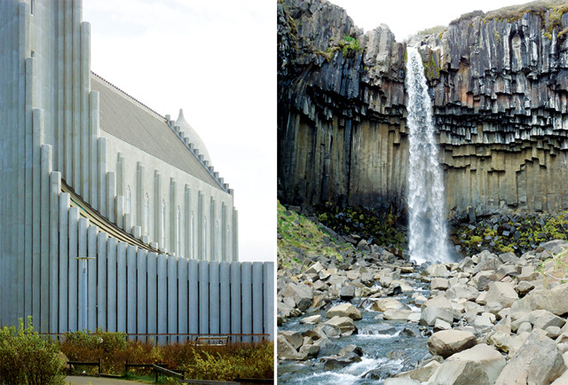
Hallgrímskirkja's six-sided columns (left) evoke the columnar jointing of Svartifoss (right), or black falls, in the Skaftafell part of Vatnajökull National Park. Credit: David B. Williams
When we awoke the next day, Sunday, the sun was shining through what we thought was a low fog bank between Heimaey and the mainland. Hoping to find some puffins — one of Iceland’s most iconic wildlife species — we threaded our way up a steep, grass-covered volcanic cone west of town. No puffins, but we discovered that the fog was actually an ash cloud from Grimsvötn. The big cloud we had seen the day before was the first pulse of the explosion, which had started about an hour before we reached the summit of Eldfell at 7:25 p.m.
Back in town after our hike, we learned that all flights to and from Iceland had been cancelled due to the eruption. We packed, caught an early afternoon ferry back to the main island and drove toward our hotel near the airport in Keflavik.
Resigned to the fact that we were stuck in Iceland for the five days we thought we’d be spending in Scotland, we decided to spend our first unexpected day in the capital city of Reykjavik, an hour-long bus ride from Keflavik. The highlight of the day was a visit to the Hallgrímskirkja, the city’s towering cathedral. Designed by Gu∂jón Samúelsson, the cathedral took almost 40 years to complete. No stone was used in its construction; instead, it is made of concrete. The main architectural motif, columnar jointing, was designed to resemble the six-sided basalt columns that sometimes result from cooling lava and are found throughout Iceland. Looking at the front of the church, you see about 30 adjacent, closely spaced columns step down from either side of the church’s central tower, evoking the columns of Svartifoss, or black falls, in the Skaftafell part of Vatnajökull National Park.
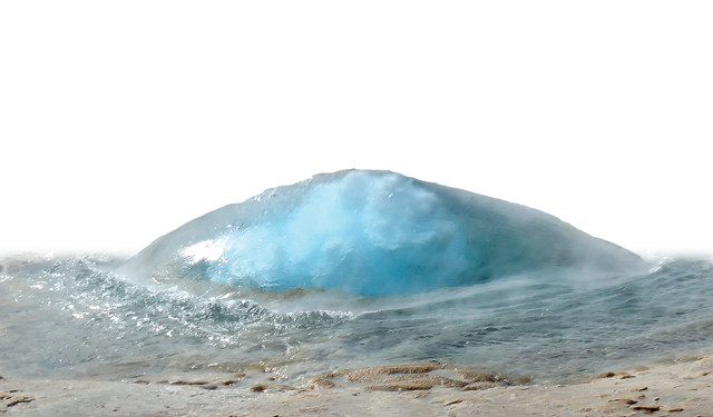
Every few minutes a jellyfish-like bubble of pearly blue water emerges from Strokkur geyser, signaling another 20-meter-high blast. Credit: David B. Williams
Day two of our entrapment involved searching for more geology; after renting another car we drove to Þingvellir, one of the few spots on Earth where a mid-ocean ridge traverses land. The name refers to the Alþingi, or general assembly, the world’s first parliament, which began about A.D. 930 and continued annually until 1798. From the visitor center, we descended down into the rift valley — down-dropped fault blocks bounded by faults and paralleled by craggy fissures, the deepest of which are water-filled. In a little more than an hour, we hiked down from the westbound North American Plate and across the spreading center of the Mid-Atlantic Ridge to the east-drifting Eurasian Plate.
Þingvellir is part of the Golden Circle tour, a trifecta of Iceland’s most famous geologic features. Best known is the town of Geysir, the location that gave us the word “geyser.” The original geyser, or “the gusher,” lost its mojo in 1916, possibly from being “half choked by visitors throwing rocks and turf” into it, as it’s often described, but nearby lies an equally impressive geyser called Strokkur. Every few minutes a jellyfish-like bubble of pearly blue water emerges from Strokkur, signaling another 20-meter-high blast of this amazing geyser.
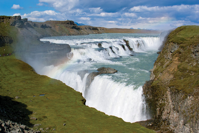
Gullfoss, or Golden Falls, with its two falls positioned at right angles, is one of Iceland's most popular waterfalls. Credit: ©Shutterstock.com/halldore
About 15 minutes down the road is the last member of the trifecta, Gullfoss, the golden waterfall. Dropping 30-plus meters over two ledges, the falls are a mixture of short whitewater drops, rising mist and basalt ledges. This was the first place that we encountered busloads of tourists.
Visitors might also want to note two mountains near the Golden Circle route. North of Þingvellir is the shield volcano Skjaldbreidur, literally “broad shield” in Icelandic, which resembles on a somewhat larger scale the broad, gently sloped shell of a limpet. Almost due south of Gullfoss rises Hekla, one of Europe’s most active volcanoes — erupting about every 40 years — and long considered in folklore to be the gates to hell. Some believe that the mountain gave us the word “heck” as a substitute for hell.
With just a few days left in our forced-extended trip, we decided to drive out to a geologic spot that much of the world learned about through a fictional discovery made on May 24, 1863, by the also-fictional German scientist Otto Lidenbrock. That day, Lidenbrock purchased a book, out of which slipped an enigmatic slip of paper containing the following statement: “Descend into the crater of Sneffels Yokul, over which the shadow of Scartaris falls before the kalends of July, bold traveller, and you will reach the centre of the earth. I have done this. Arne Saknussemm.” So began the adventures told in Jules Verne’s “Journey to the Center of the Earth.”
Verne described the volcano as extinct and was correct to the extent that the last known eruption of Snaefellsjökull was more than 1,750 years ago. The mountain sits at the eastern edge of the Snaefellsnes, a peninsula that juts out into the North Atlantic from Iceland’s west coast. I wish we could say that we saw where Lidenbrock entered the Earth, but clouds prevented us from seeing much of the fabled mountain.
Nor could we find another site we sought. On the north side of the peninsula lies a 4,000-year-old basalt flow known as the Berserkjahraun. According to the 13th-century “Eyrbyggja” saga, one of the legendary accounts of early life in Iceland, a pair of warriors built a trail across the lava field in order for one of them to win the hand of a landowner’s daughter. The warriors were berserkers, Swedish mercenaries famed for their fighting frenzy and lack of fear, from which the modern phrase “going berserk” is derived.
Wandering around Iceland, we kept encountering stories such as this one, stories of events that occurred hundreds of years ago. I have been to places with histories that stretch back further in time, but as with the geology in Iceland, never have I felt such a tangible connection to the history. Maybe that is because of how Icelanders refer to the stories in such a matter-of-fact manner, as if they just happened. Or maybe it’s because so little of the island’s physical appearance has changed: If one of the berserkers appeared today, the landscape would look about the same to him now as it did then. Iceland’s history, both human and geologic, is visceral and present, and should be experienced firsthand. Perhaps you will be lucky enough to be trapped by geology as well.
© 2008-2021. All rights reserved. Any copying, redistribution or retransmission of any of the contents of this service without the expressed written permission of the American Geosciences Institute is expressly prohibited. Click here for all copyright requests.