
by Terri Cook and Lon Abbott Friday, May 19, 2017
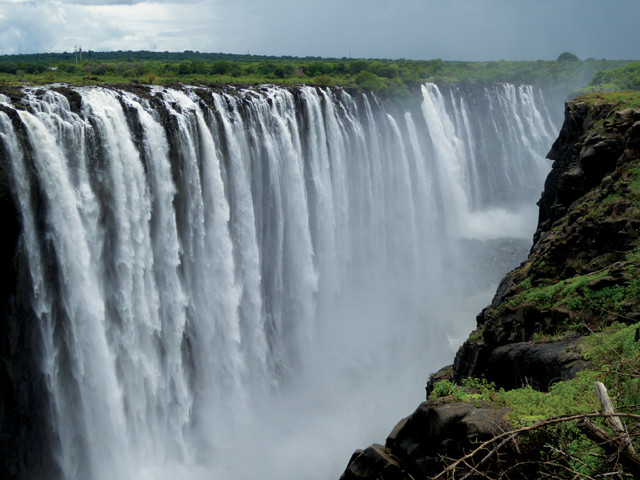
The local name for Victoria Falls translates as "The Smoke That Thunders." Credit: Lon Abbott and Terri Cook.
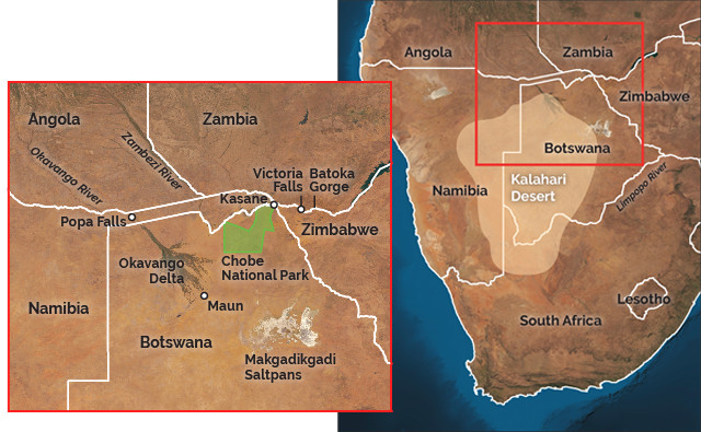
After landing in Windhoek, Namibia, on the western edge of the Kalahari Desert, our family embarked on an African adventure with two exhilarating objectives: to see iconic African animals in the Okavango Delta, a major river delta in the middle of the dry Kalahari, and to view the thundering Victoria Falls, a day’s drive from the delta on the desert’s northeastern side. Most tourists consider these two magnificent UNESCO World Heritage sites to be wholly unrelated. But to a geologist, they are inextricably linked via major hydrologic changes that have swept across the region in response to both subtle tectonic movements and major Pleistocene climate fluctuations.
The Kalahari Desert covers 900,000 square kilometers of southern Africa. Credit: both: K. Cantner, AGI.
“Although our excitement swelled as we collected our rental car and swung east onto the Trans-Kalahari Highway’s immaculate pavement, we were soon lulled into a hypnotic state by the monotonously flat landscape. Crossing the border into Botswana, the horizon remained unchanged: All we could see was a veneer of sand coating the seemingly endless, billiard-table-flat plain of the vast southern African Plateau.
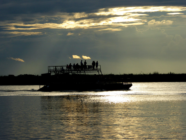
Boat trips on the Chobe River, a tributary of the Zambezi, are one of the best ways to glimpse world-class African wildlife. Credit: Lon Abbott and Terri Cook.
This plateau rose in response to the upwelling of two hot spots associated with the breakup of the Pangean supercontinent between 180 million and 130 million years ago. The Karoo hot spot, which facilitated the separation of Africa from India and Antarctica during the growth of the Indian Ocean, raised the plateau’s southeastern margin to elevations as high as 3,000 meters. Activity at the Paraná-Etendeka hot spot, which was instrumental in splitting Africa from South America, similarly uplifted the plateau’s northwestern flank. Between these two elevated regions, the Kalahari Desert occupies a bowl-shaped depression that ranges from 900 to 1,500 meters above sea level.
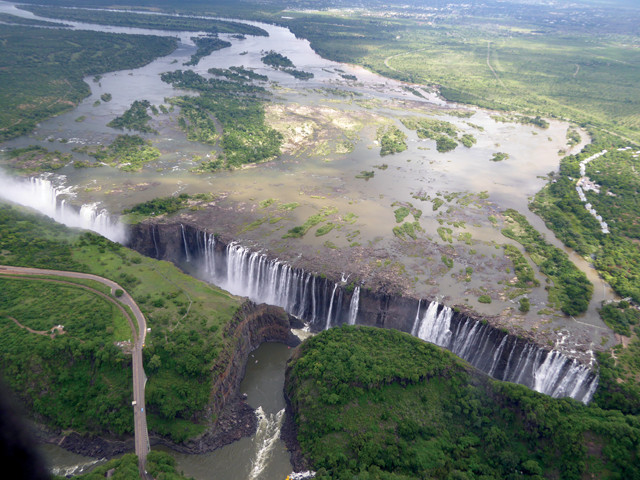
The biggest of several deranged drainages of the southern African Plateau is the Zambezi, which plunges over the spectacular Victoria Falls along the Zimbabwe-Zambia border. Credit: Lon Abbott and Terri Cook.
When the plateau first rose, the ancestral Limpopo River drained the majority of the area. But 65 million years ago, motion along several major faults gently warped sections of the plateau, locally raising or lowering its elevation by a few meters. Subtle though they were, these changes were enough to dramatically alter the hydrology of a region as flat as the Kalahari, producing what geologists call a “deranged” drainage network. The changes included the “beheading” of the ancestral Limpopo River, meaning the river’s headwaters were captured by another drainage system. Today, the Limpopo’s severed head comprises the headwaters of both the mighty Zambezi River, the source of the water that plunges over Victoria Falls, and the internally draining Okavango River — the two attractions we had traveled so far to see.
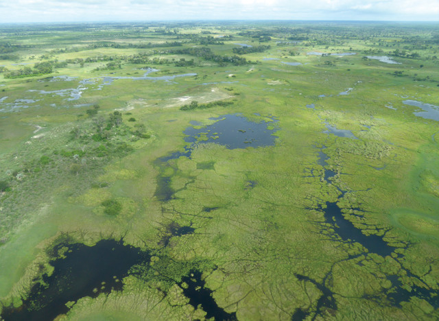
The Okavango Delta, one of the world's largest inland deltas, sustains an abundance of iconic African animals. Credit: Lon Abbott and Terri Cook.
Subtle tectonic shifts throughout the last 65 million years, combined with the growth and spillover of lakes during wet climatic periods, have reorganized this deranged drainage network over and over again, repeatedly joining the Okavango River with the Zambezi, only to separate them once again. The rivers were last connected about 10,000 years ago, and scientists expect the Zambezi to recapture the Okavango once again in the near geologic future, within the next million years.
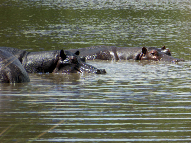
The marshes of the Okavango Delta are an ideal habitat for hippos. Credit: Lon Abbott and Terri Cook.
Our first destination was Maun, Botswana, a city of 55,000 that serves as the gateway for wildlife safaris into the magnificent Okavango Delta, the end of the Okavango River’s 1,600-kilometer journey from the moist Angolan Plateau to a low, fault-bounded trough in northwestern Botswana. The river tumbles into the trough at Popa Falls, where it drops four meters before spreading out via a series of distributaries that, at 15,000 square kilometers, comprise one of the world’s largest inland deltas.
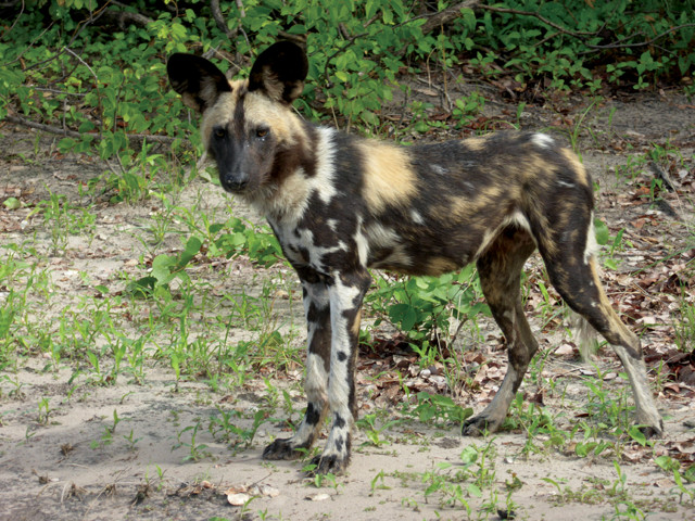
Although there are fewer than 7,000 painted dogs left in the wild, packs of the endangered animals roam the delta. Credit: Lon Abbott and Terri Cook.
Not surprisingly, this abundance of water in the desert attracts a profusion of animals, making the delta world-renowned for wildlife viewing. Elephants, giraffes, hippos and many more iconic African animals are plentiful in the marshlands year-round. The best time for a wildlife safari is in winter (June through October), when the temperature is most agreeable and the mosquitoes are least plentiful. The delta’s hydrology also favors a winter visit. Water levels begin to rise with the local summer rains in January and February, but they usually peak in May, when the pulse of precipitation that fell on the Angolan Plateau finally reaches the delta. That makes May through August the ideal time to view the delta’s wildlife on a relaxing boat cruise. If you want to do a four-wheel-drive or fly-in safari, going in September — when water levels drop dramatically and force the animals to crowd around a few, dwindling waterholes — maximizes your chances of seeing a large number of diverse animals.
Kubu Island in the Makgadikgadi Saltpans in southern Botswana. Credit: Stefan Huchler, GFDL/CC BY-SA 3.0.
Because we visited during the summer, when water levels are too low for the boat trip, we toured the delta on a Land Rover safari arranged through our campground. Temperatures were warm during the day, but when the vehicle was moving the breeze kept things comfortable, and it was so cool before sunrise that we had to wear wind jackets. Local rains had replenished many watering holes, so animals were spread far and wide. Our friendly and expert guide knew where to find them; by the end of our delightful one-day safari, we had seen hundreds of animals, including elephants, giraffes, cape buffalo, hippos, zebras, gazelles, a pack of endangered wild dogs and many more.
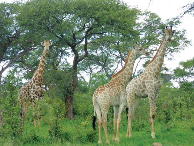
Giraffes eat beside the highway. Credit: Lon Abbott and Terri Cook.
Maun, the Okavango Delta’s tourist hub, sits on comparatively dry ground atop an upraised block adjacent to the fault that bounds the trough’s southeastern side. Displacement across this fault has been so minor, however, that the upraised block stands just a couple of meters higher than the delta, so Maun has plenty of boggy areas during the wet summer season. The Makgadikgadi Saltpans, which lie southeast of Maun’s upraised fault block, are even lower than the Okavango Delta, so in especially moist years, the delta’s water level can rise high enough to overtop the fault scarp, causing water to spill into, and fill, the saltpans. Any water in these shallow depressions evaporates quickly in the hot, dry climate, leaving behind the salt deposits. Collectively, the 10 depressions that constitute the Makgadikgadi Saltpans form the largest such complex on Earth.
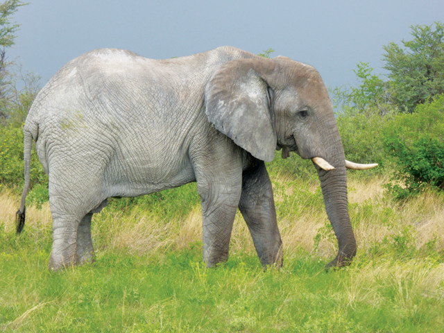
An elephant lumbers alongside the highway between Maun and Kasane in Botswana. Credit: Lon Abbott and Terri Cook.
Around the pans’ perimeters, the shorelines of three ancient lakes, which once covered both the Okavango Delta and the Makgadikgadi Saltpans, can be traced at elevations of 912, 920 and 945 meters. Scientists have reasoned that these ancient lakes could only fill during the rare times when precipitation increased across southern Africa and the entire flow of both the Okavango and the upper Zambezi rivers entered them. At such times, the lower Zambezi River was much smaller than it is today, deprived as it was of the modern Zambezi’s considerable headwaters catchment area in Angola. But the vastly greater volume of internally draining water surely produced lush wetlands whose size dwarfed that of the modern Okavango Delta.
The lake with the highest shoreline would have covered 34,000 square kilometers, making it considerably larger than modern Lake Erie. When this ancient lake rose to that height, it spilled northward through a slight depression on the basaltic plateau called the Katombora Gap. From there, the water flowed into northeastern Botswana’s Chobe swamps to join the course of the modern Zambezi River upstream of Victoria Falls. The Chobe swamps form the heart of Chobe National Park, our next destination, which is another famous wildlife spot known for its unusually large elephant herds and lion prides.
We never imagined that the six-hour drive on the main highway between Maun and Kasane, the 8,000-person town that is the gateway to Chobe National Park, would turn into a world-class wildlife experience. But soon after departure we saw an elephant wandering along the highway’s grassy shoulder and quickly pulled off to marvel at the unobstructed view of this majestic animal. We were similarly excited by the second and third roadside elephant sightings, but had almost become blasé by the time we reached Kasane, when our roadside wildlife tally stood at 32 elephants and 10 giraffes.
A succession of joints controls the zigzagging course of the Zambezi River below Victoria Falls. Credit: Lon Abbott and Terri Cook.
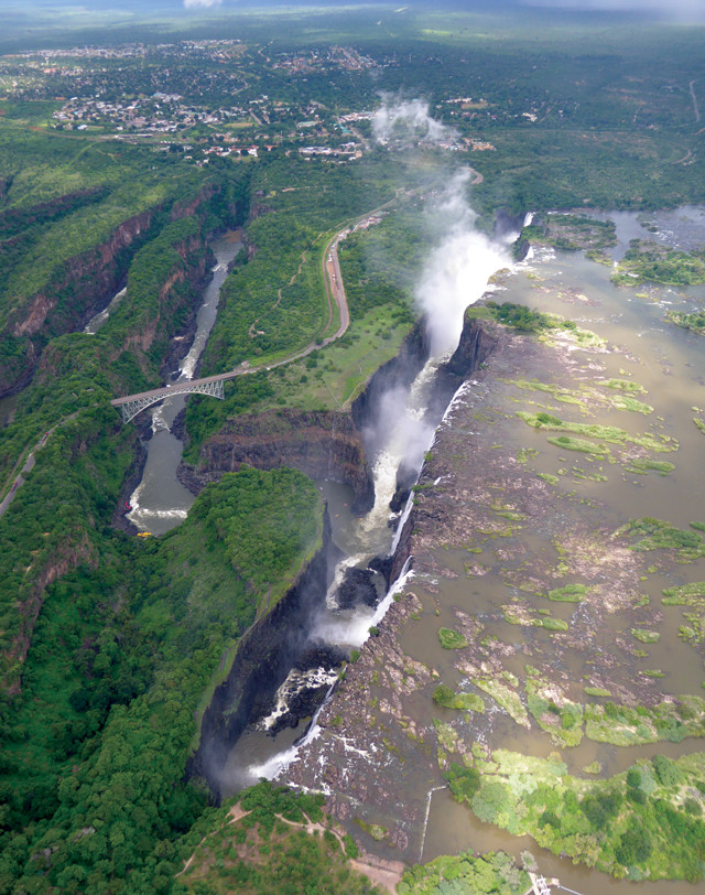
In 1855, when David Livingstone reportedly became the first European to lay eyes on the majestic waterfall on the Zambezi River at the border between modern Zambia and Zimbabwe, he predictably named it after the grandest person he could think of — his monarch, Queen Victoria. Most of the world still uses that prosaic name for this natural wonder, but the local Tonga people know it by a more poetic name: Mosi-oa-Tunya, which means “The Smoke That Thunders.” In our many travels across six continents, we have witnessed few sights as awe-inspiring as watching the Zambezi’s entire flow pour over a 108-meter-high cliff of hard, black basalt. Thanks to a promontory of land immediately downstream of the waterfall, visitors have a perfect viewing platform from which, amid the thundering spray, they can gaze at the 1.7-kilometer-wide wonder.
Adventure activities, including whitewater rafting, ziplining and bungee jumping, abound in the stunning Batoka Gorge. Credit: Lon Abbott and Terri Cook.
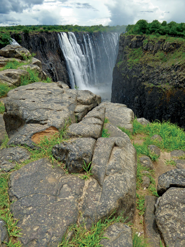
The face of Victoria Falls is shaped by a series of parallel joints in the resistant basalt that forms the gorge rim. Credit: Lon Abbott and Terri Cook.
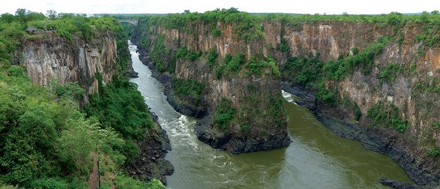
“The ancestral version of Victoria Falls likely formed about 75 kilometers downstream of its present location, where the equivalent of today’s lower Zambezi River probably cascaded down the edge of a plateau capped by the Batoka basalt, which erupted 180 million years ago from the Karoo hot spot. Although the Batoka basalt is a hard rock that resists erosion well, it is criss-crossed by a series of paper-thin vertical cracks, called joints, created by tectonic stresses. During the Pleistocene, when the upper and lower Zambezi initially merged to establish the river’s modern course, its volume, and hence its erosional power, increased dramatically, allowing it to exploit the lines of weakness provided by these joints. By plucking off blocks of basalt, the river carved out a deep gorge and converted the cascade into a waterfall that gradually migrated farther and farther upstream.”
Today, the joints continue to play a major role in shaping this natural wonder. The falls pour down the face of one such joint, which the river has widened to form a narrow gorge. Visitors view the falls from a promontory that marks the other side of the widened joint. For the next 75 kilometers, the river races through the beautiful Batoka Gorge. It’s definitely worth splurging on a 15-minute helicopter ride for amazing views of the falls and an appreciation of the circuitous nature of the river’s path through the Batoka Gorge, where it zigzags from one joint to the next. From the helicopter you can also see how flat and wide the river valley is upstream of the falls, and look down on a joint there that runs parallel to the joint over which today’s falls tumble. From this perch it doesn’t take much imagination to realize that the river will soon pry off the basalt block that lies between the two joints, thereby taking the next step in its inexorable march upstream.
The Batoka Gorge is an integral part of the Victoria Falls experience. The historic Victoria Falls Bridge that crosses the gorge just downstream was an engineering marvel when it was built in 1905. The bridge formed a critical link for a railroad line that Cecil Rhodes — the controversial figure who founded the De Beers diamond company and was prime minister of the Cape Colony from 1890 to 1896 — envisioned stretching from Cape Town to Cairo. Rhodes instructed the engineers to build the bridge where spray from the nearby falls would shower passing trains. Today the bridge forms the main road link between Zimbabwe and Zambia. On a stroll across the bridge you can view the falls from both countries and also watch the mixed emotions on the faces of the tourists who launch themselves off of it tied to a bungee cord. You can also cross the gorge on a zipline, as our kids did, catapult yourself off its rim on a “gorge swing,” and raft the Class V (expert) rapids on excursions that last from half a day to a week.
While driving back to Namibia across the northern Kalahari, over the same, pancake-flat landscape that we saw in the southern Kalahari, it was easy to envision that a day will soon come (geologically speaking) when the Kalahari’s extensive river network will once again shift, drying up the Okavango Delta and sending its waters over an even bigger Victoria Falls. Until then, these life-giving waters make the Kalahari region the place to see both magnificent wildlife and one of the world’s great waterfalls all in a brief traverse.
© 2008-2021. All rights reserved. Any copying, redistribution or retransmission of any of the contents of this service without the expressed written permission of the American Geosciences Institute is expressly prohibited. Click here for all copyright requests.