
by Terri Cook Monday, July 6, 2015
The Trans-Pecos region, part of the Chihuahuan Desert, bears little resemblance to eastern Texas, which is flatter, wetter and more populated. Credit: ©Adbar, CC BY-SA 3.0.
When Robert T. Hill first arrived in Texas in 1874 at the age of 16, little was known about the geology of the arid, far-western corner of the state. While working at his brother’s newspaper in the frontier town of Comanche, Hill, who would come to be known as the Father of Texas Geology, became fascinated by fossils along the slopes of the region’s blocky buttes. After searching for information on the rocks he was looking at, Hill realized they’d never been formally described. With his enthusiasm growing, he returned to the eastern U.S. to pursue a geology degree at Cornell University. In the course of pursuing his thesis, Hill participated in an expedition to west-central Texas, during which he defined the “Trans-Pecos” area, the remote region of the state west of the Pecos River.
Part of the Chihuahuan Desert, the Trans-Pecos bore little resemblance to the flatter, wetter, more populated eastern portions of the Longhorn State that Hill had previously visited. The aridity, high elevation and remoteness of the Trans-Pecos profoundly influenced the region’s human history. Most peoples sought to cross through, not settle in, the area; prehistoric nomads, Spanish conquistadors, Comanche raiders and emigrant wagon trains in search of gold all passed through, but few remained.
Like the migrants of old, today’s visitors to the far west of Texas are often just traveling through. But those who decide to stop and explore the Trans-Pecos will discover a region of profound beauty, rich cultural history — and fascinating and diverse geology.
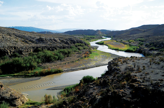
Aside from the Rio Grande and a couple of other rivers, the Trans-Pecos region is largely desert. Credit: NPS Photo/Ann Wildermuth.
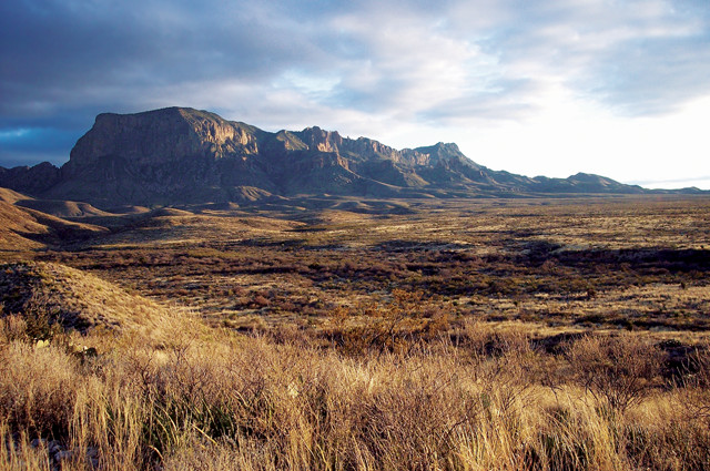
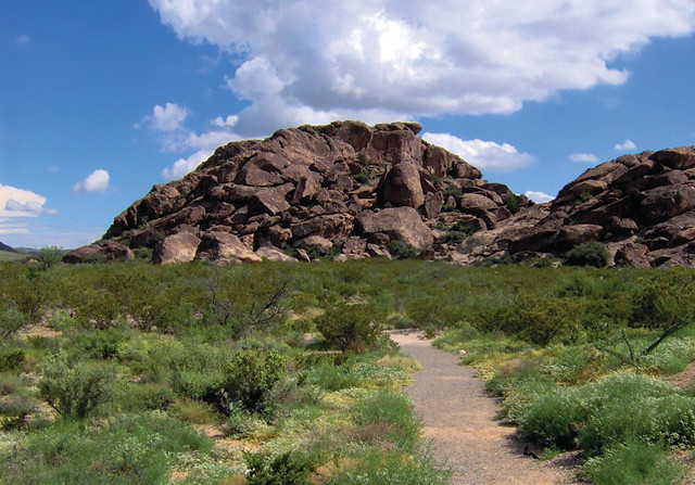
The Trans-Pecos is the highest and most mountainous part of Texas, as well as the least populated, with just 212,000 people (outside the city of El Paso) scattered across an area about the size of Maine. Credit: both: K. Cantner, AGI.
The Trans-Pecos is the highest and most mountainous part of Texas, as well as the least populated, with just 212,000 people (outside the city of El Paso) scattered across an area about the size of Maine. The region is underlain by igneous and metamorphic rocks that record two major mountain-building episodes. The first was the Precambrian Llano Orogeny, which marked the final assembly of the supercontinent Rodinia. The second mountain-building episode occurred during the Mississippian Epoch and formed the major east-west-trending Marathon-Ouachita fold-and-thrust belt. This belt formed the Ouachita highlands, part of the long suture that welded the continents together into Pangea, Earth’s most recent supercontinent. During the subsequent Pennsylvanian Epoch and Permian Period, these highlands bordered several inland marine basins, which collectively comprise West Texas’ oil-rich Permian Basin. Limestone reefs that rimmed the deeper of these basins today host some of the state’s most productive oil reservoirs.
As the Paleozoic Era drew to a close, the inland seas gradually withdrew, leaving behind shallow bodies of water where thick evaporite deposits of salt, gypsum and red mud accumulated in a hot, arid climate. The locus of tectonic activity then shifted, but by the Early Cretaceous, about 140 million years ago, shallow seas once again reached the Trans-Pecos region. These seas continued to deepen during the Cretaceous, leaving thick accumulations of fossil-rich marine rocks across much of the state, including some of the deposits that initially caught Hill’s attention. This was the last major seaway to cross Texas. By the beginning of the Cenozoic Era, a third mountain-building episode, the Laramide Orogeny, began uplifting the Rocky Mountains and adjacent areas, including the Trans-Pecos.
Since the Laramide uplift, the rugged landscape of the Trans-Pecos region has been predominantly shaped by two geologic processes — volcanism and faulting — associated with the area’s transition from a region of compression to one of extension. The volcanism, which lasted roughly from 47 million to 17 million years ago, produced at least 14 major volcanic centers, as well as thick deposits of ash and lava. Extensional faulting, which began about 30 million years ago, occurred along a series of north-south trending normal faults that dropped valleys down between narrow, “fault-block” mountain ranges, creating the easternmost portion of the modern Basin and Range Province — a landscape once described by an orbiting astronaut as resembling a herd of caterpillars all heading north.
You can hike across some of the world’s best exposures of ancient reef rocks in Guadalupe Mountains National Park. The park protects the Late Permian El Capitan limestone reef, which is so well preserved that it looks as if the water just drained from it yesterday.
The Trans-Pecos’ El Capitan was part of a 650-kilometer-long reef that nearly encircled the Delaware Basin, the middle of the Permian Basin’s three shallow arms. Only a narrow inlet, which connected the Delaware to the Permian Ocean surrounding Pangea, was not enclosed. Unlike modern reefs built mainly by a framework of corals, however, El Capitan and the other Permian reefs consisted primarily of calcareous sponges and algae encrusted with “lime” (calcium carbonate) secreted by marine organisms and precipitated directly from seawater in the vast tropical ocean that covered the region.
After being buried for millions of years, these reef deposits were re-exposed by Basin and Range extension, which created a major normal fault on the west side of the Guadalupe Mountains, separating the range from the adjacent valley. During this process, the Guadalupe block was thrown upward and also tilted, exposing El Capitan.
The best place in the national park to see an entire reef sequence, including its three major depositional environments, called facies, is along the 13.5-kilometer-long (round trip) Permian Reef Trail, which begins near the mouth of McKittrick Canyon, the largest cleft carved through the Permian reef complex. Interpretive signs help visitors navigate through the reef’s facies — the forereef, reef crest and backreef — whose distinctive rock types reflect the different assemblages of biota and the different characteristics of the environments where they accumulated.
The Guadalupe Mountains are famous for preserving an entire reef sequence. Credit: ©Leaflet, CC BY-SA 3.0.
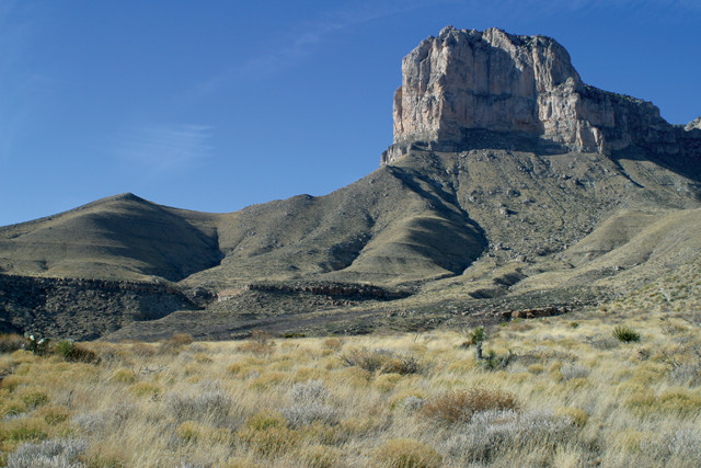
The Permian-aged El Capitan limestone reef in Guadalupe Mountains National Park is one of the world's best preserved ancient reefs. Credit: ©Leaflet, CC BY-SA 3.0.
The trail begins by crossing a series of thin bands of limy mud, limestone, and sandstone deposited on the deep basin floor on the reef’s seaward side. The trail then begins to climb the forereef, an increasingly steep slope of talus and breccia shed off the reef crest. Had you wandered here 250 million years ago, the topography would have been very similar, although you’d be standing 450 meters below the sea surface.
As the trail continues to climb the escarpment, it passes the massive (meaning not stratified) heart of the reef, which lacks layers because its core was formed by the steady growth of living organisms instead of sedimentary layers. The trail then ascends an additional 100 vertical meters before reaching the backreef facies. During the Permian, a broad, shallow lagoon — a quiet place rarely affected by waves or currents — stretched to the shores of the continent. Thin bands of gray carbonates interspersed with occasional siltstone and sandstone beds, visible near the end of the trail, accumulated in this stagnant and often muddy environment.
In other parts of Texas, and around the planet, buried basins similar to the Delaware now serve as important petroleum reservoirs. Because of the unparalleled opportunity to see a comparable structure above ground, geologists of all manner from around the world crisscross the trails of Guadalupe National Park on a regular basis.
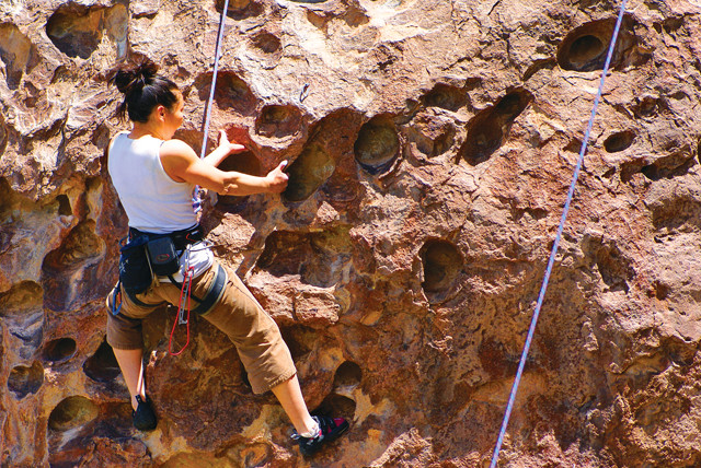
Rock climbing and bouldering are popular activities in Hueco Tanks State Park & Historic Site. Credit: ©Nick Page, CC BY-NC-ND 2.0.
About 50 kilometers northeast of El Paso, Hueco Tanks State Park & Historic Site, a group of low-lying hills composed of syenite, an intrusive, quartz-poor igneous rock, rise above the dry Chihuahuan Desert to form an oasis that has served as a refuge for plants and animals — and people for more than 10,000 years. Hueco, the Spanish word for “hollow,” refers to the numerous depressions that pockmark the site’s rock formations. During the rainy season the huecos hold water, attracting a variety of animals, as well as people.
The site’s many overhangs and the canyons between the outcrops provide shelter, shade, moisture and pockets of fertile soil, as well as blank natural canvases for rock art. Thousands of pictographs left by prehistoric and historic Native Americans testify to the cultural significance of this site, which, thanks to its reliable source of water, also served as a stop on the pioneer-era Butterfield Overland Mail Route.
Hueco Tanks hosts a group of low-lying hills composed of syenite, an intrusive, quartzpoor igneous rock. Credit: ©Brian Stansberry, CC BY 3.0.
The rocks at Hueco Tanks formed below ground 34 million years ago, around the time that the Trans-Pecos was transitioning from a compressional to an extensional regime. These hills formed after molten magma intruded into older limestone, and slowly cooled to form the syenite’s large crystals. Erosion eventually removed the limestone, exposing the rock and carving out the huecos, which enable rock climbers and boulderers to more easily clamber to the top of the otherwise steep, smooth walls.
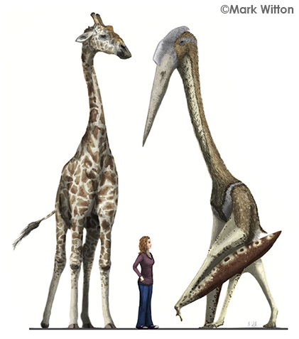
Quetzalcoatlus northropi is only known from wing bones found in Big Bend National Park. Its 11-meter wingspan indicates it was likely similar in size and appearance to the closely related Aramabourgiania, shown here with a modern giraffe. Credit: Mark Witton.
Like the rest of the Trans-Pecos, the region where the Rio Grande forms the “Big Bend” in the Texas-Mexico border has also been shaped by compression, volcanism and normal faulting. Much of this rugged landscape has been created since the inland Cretaceous sea deposited the limestone layers visible throughout much of Big Bend National Park, including in the walls of three spectacular canyons carved by the Rio Grande and the Dead Horse Mountains.
Fossils found in the park indicate that 100 million years ago, as the inland sea slowly retreated, the region boasted an abundance of life. Shallow pools of water hosted oysters, giant clams and a variety of fish and marine reptiles, and petrified wood, fossilized turtles and the remains of a crocodile nearly 15 meters long have been found in near-shore deposits. But the park’s most famous fossil is the Quetzalcoatlus northropi, an extinct flying pterosaur with an impressive 11-meter-long wingspan.
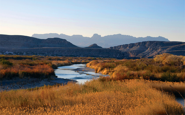
Big Bend National Park is named for where the southeast-flowing Rio Grande swoops around dramatically to the north-northeast, forming the "big bend" on the Texas-Mexico border. Credit: NPS Photo/Cookie Ballou.
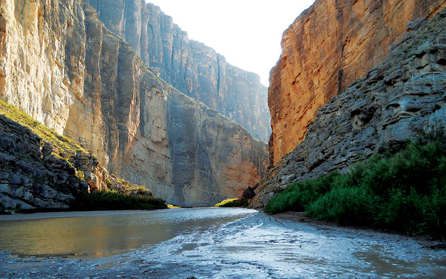
Thick limestone beds line the rivers in much of the Trans-Pecos, such as in Santa Elena Canyon. Credit: NPS Photo/Ann Wildermuth.
Volcanism occurred in the Chisos Mountains between 38 million and 32 million years ago, leaving behind colorful volcanic ash and lava. Credit: ©R. Hensley, CC BY 2.0.
Near the end of the Cretaceous, compression from the Laramide Orogeny deformed and uplifted the park’s Cretaceous limestones and overlying sedimentary layers, including Big Bend’s Mariscal Mountain, which is considered the southernmost extension of the Rocky Mountains. Although most of the softer, overlying sediments have since been washed away, the limestones, which erode very slowly in the region’s arid environment, form prominent cliffs in the park today.
Cenozoic mammal fossils, including those of horses, camels and rodents, are also found in the park. Cenozoic volcanism occurred in the Chisos Mountains between 38 million and 32 million years ago. These eruptions produced the colorful volcanic ash and lava for which the national park is known. By 26 million years ago, Basin and Range extensional faulting reached Big Bend, creating steep fault-block mountain ranges resembling the Guadalupes to the north.
One such block that dropped down along normal faults included most of the center of today’s national park. Evidence of this faulting is visible at the tunnel near the park’s Rio Grande Village, where the layer of limestone through which the tunnel passes is the same as, but more than 1,450 meters lower than, the one uplifted to form the skyline of the Sierra del Carmen mountains to the east. A magnitude-5.6 earthquake that occurred in 1995 near the town of Marathon, about 110 kilometers north of the park’s northern boundary, suggests that the same stresses continue to sculpt this area today.
It is no wonder that Robert Hill changed careers after traveling through the captivating and diverse geology of the Trans-Pecos in the late 19th century. And there’s little doubt this incredible region can still convert other would-be geologists today.
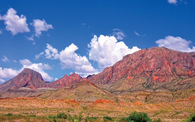
The Chisos Mountains area in Big Bend. Credit: NPS Photo/Reine Wonite.
© 2008-2021. All rights reserved. Any copying, redistribution or retransmission of any of the contents of this service without the expressed written permission of the American Geosciences Institute is expressly prohibited. Click here for all copyright requests.