
by Callan Bentley and Ken Rasmussen Friday, November 9, 2018
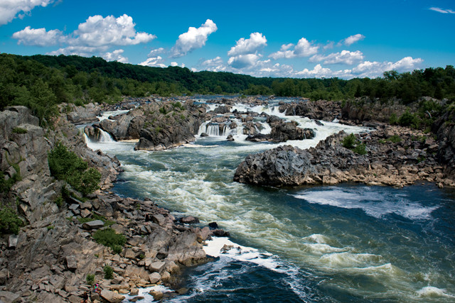
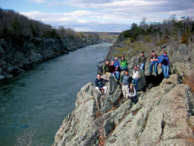
The rushing whitewater and jagged rocks of Great Falls, along the Potomac River about 20 kilometers upstream of downtown Washington, D.C., make for one of the most striking natural scenes in the metropolitan area. Here, the river is gradually incising the Piedmont province's hard rocks, oceanic sedimentary rocks that were metamorphosed during Appalachian mountain building roughly 460 million years ago. Credit: ©iStockphoto.com/DouglasRissing.
Washington, D.C., is one of the biggest centers of power on the planet — a nexus of domestic and international politics, backroom deal-making and patriotic reflection. But there is so much more to D.C. than politics. Among its other attributes, the D.C. metro area is a powerhouse of scientific research, and more specifically geoscience research. It’s home to institutions like the U.S. Geological Survey, the Carnegie Institution for Science, the Smithsonian Institution, the National Institute of Standards and Technology, and the headquarters of NASA and NOAA, along with a slew of universities, advisory and lobbying groups such as the National Academy of Sciences, the American Geosciences Institute (which publishes EARTH) and the American Geophysical Union, which this month will host its annual fall meeting in the city. D.C. is also home to numerous longstanding geological interest groups, including the Potomac Geophysical Society, the Paleontological Society of Washington and the 125-year-old Geological Society of Washington.
The federal city was established in 1790 as the seat of the U.S. government, using land ceded along both banks of the Potomac River by Maryland and Virginia that included two preexisting ports: Georgetown, Md., and Alexandria, Va. And in 1791, Major Andrew Ellicott and his surveying team began marking the borders of the newly minted, 260-square-kilometer city with boundary stones, made of local Aquia Creek Sandstone, laid every 1.6 kilometers along the 64-kilometer-long perimeter. A few decades later, Washington’s present-day outline was established when Virginia took back its contribution in the 1846–47 retrocession of Arlington and Alexandria. Although its terrain is more subdued than other parts of the country, Washington, D.C., and its immediate surroundings in Maryland and Virginia, showcase some terrific geology. Visitors should consider exploring both what’s visible in natural rock outcrops and what’s revealed in the capital’s diverse suite of evocative building stones and monuments, particularly those gathered on the National Mall.
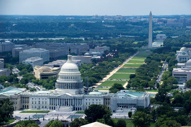
Washington, D.C., sits along the north side of the Potomac River, opposite Virginia. After the city was established in 1790, the Capitol and the White House were the first buildings erected. Once marshland, the area between the river, the Washington Monument and the Lincoln Memorial at the western end of the National Mall was later filled in during reclamation efforts. Credit: U.S. Air Force photo by Airman 1st Class Philip Bryant.
Washington, D.C., sits astride the Fall Zone of the Potomac River, the stretch where rapids, rock knobs and waterfalls first appear as one heads upstream. The Fall Zone, which runs for roughly 1,400 kilometers along the Atlantic Seaboard, cutting northeast to southwest through D.C., constitutes the boundary between two major geological provinces: the Piedmont to the northwest and the Coastal Plain to the southeast. The Piedmont mostly comprises considerably older, relatively erosion-resistant high-grade metamorphic rocks and igneous intrusions; the Coastal Plain consists of younger, largely unlithified deposits of gravel, sand, mud and shells that are easily eroded by the Potomac and other rivers.
In the early days of European colonization, the jutting rocks and whitewater of the Fall Zone represented navigational hazards for river traffic that obstructed commerce. The Washington City Canal through D.C., and the C&O Canal, were constructed in the early 19th century to help circumvent these hazards. On the positive side, the constriction and fall of the Fall Zone lent itself to the positioning of mills and eventually to hydroelectric power plants. Up and down the East Coast, major cities — from Raleigh to Richmond, D.C. to Baltimore, and northward to Philadelphia and Trenton — were founded along this geological barrier.
Heading upstream between D.C. and Virginia, the flat land on either side of the Potomac begins rising near Theodore Roosevelt Island, and suddenly looms high above the river as you pass by Georgetown to the north and Rosslyn to the south. Just north of the island, snaggletoothed nubbins of hard rock also begin poking up through the water. These are topographic signals of the transition between the Coastal Plain and the Piedmont.
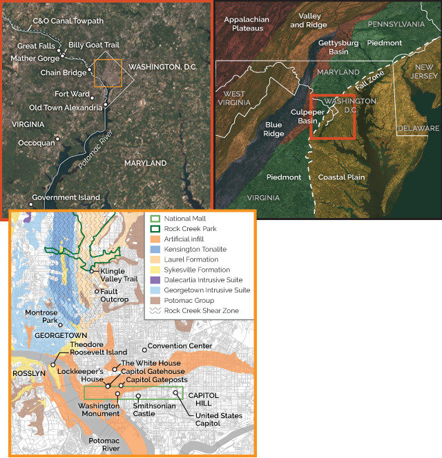
The city and its surroundings sit astride the Fall Zone, which marks the boundary between the Piedmont province to the west and the Coastal Plain to the east. Credit: all: K. Cantner, AGI.
“Piedmont” translates from French as “foot of the mountains,” an allusion to the province’s position adjacent to the modern Appalachian Mountains. What we call the Appalachians today includes the next few geologic provinces to the west of the Piedmont: the Blue Ridge, the Valley and Ridge, and the Appalachian Plateaus. But, geologically speaking, the Appalachian Mountain Belt — once a mightier, wider and more easterly range — comprises the Piedmont, Blue Ridge and Valley and Ridge. (There were additional Appalachian provinces to the east of the Piedmont when the mountains were young and Pangea was intact, but these related rocks were torn asunder beginning in the Late Triassic and now lie across the Atlantic Ocean forming the bedrock beneath the western Sahara.) In fact, Piedmont rocks were subjected to more deformation and metamorphism than those of the Blue Ridge and Valley and Ridge because they sat lower in the crust, so the name “Piedmont” is apropos in the sense that these rocks represent the deepest roots of the original Appalachian Mountains.
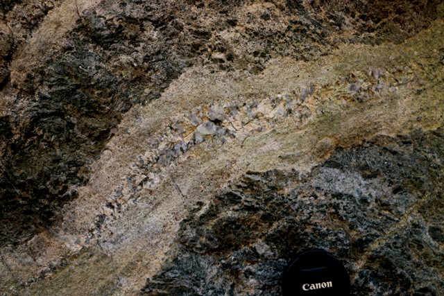
Along this stretch of the Potomac near Chain Bridge in the far western corner of the city, visitors can see the rocks of the Sykesville Formation, Late Precambrian to Early Cambrian muds, sands and larger sediments deposited on the submarine edges of the ancestral North American continent, and later lithified and metamorphosed. Credit: Famartin, CC BY-SA 4.0.
Examining the rocks of the Sykeville Formation reveals inclusions of granite, amphibolite, gneiss and schist in a mica-rich matrix. Credit: Callan Bentley.
Prior to being heated and squeezed as the Appalachians formed, the rocks of the Piedmont were sediments and volcanic rocks that originated along the continental margin and in the Iapetus Ocean. In the D.C. region, the Piedmont is subdivided into a half dozen terranes, and in the city itself, the Potomac Terrane is the part of the Piedmont that sees the most daylight. The Potomac Terrane comprises the Laurel Formation and the Sykesville Formation, layers of lithified and metamorphosed Late Precambrian to Early Cambrian mud, sand and larger sediments deposited as turbidites and conglomerates on the submarine edges of the ancestral North American continent of Laurentia. Turbidity currents (dense clouds of water and sediment hugging the seafloor) that avalanched down the continental slope into the depths of the ocean dumped these sediments into graded beds on the seafloor.
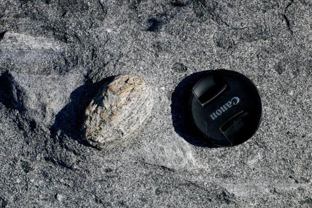
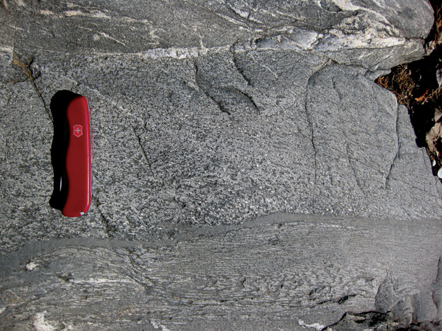
A great place to examine these rocks — with cobbles of granite, amphibolite, gneiss and schist in a mica-rich matrix — is in D.C.’s westernmost corner near Chain Bridge, where they’re exposed on a rocky terrace near the whitewater of the Potomac’s Little Falls section. Just north of the bridge, visitors can park along Clara Barton Parkway, then descend to the river’s edge along the C&O Canal towpath and forest trails. Another viewing locale is at the northernmost nose of Roosevelt Island, most directly accessible via the western-side walking trail that brings you to a view of the Georgetown waterfront just across the river.
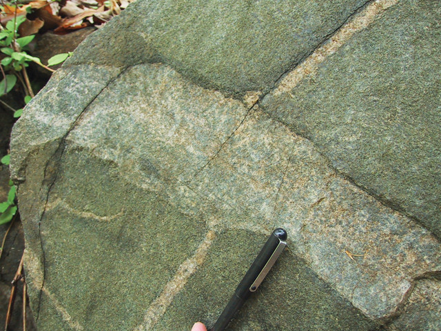
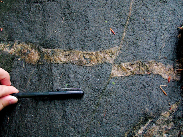
A variety of metamorphosed Piedmont rocks can be seen along the Billy Goat Trail, including relict graded beds from pre-Taconian Orogeny turbidites. Credit: Callan Bentley.
Migmatites in which partial melting of metamorphosed rock resulted in granitic magmas that recrystallized in place can also be seen on the Billy Goat Trail. Credit: Callan Bentley.
The Appalachian Mountains started forming in the early Paleozoic as the Iapetus closed and Pangea was assembled. Several landmasses accreted to the eastern margin of Laurentia during a series of three major collisional and mountain-building episodes. The first, The Taconian Orogeny, saw an island arc — something akin to the modern-day Philippines — added to North America. This was followed by the addition of a microcontinent — Madagascar is a modern-day analogue — during the Acadian Orogeny, and the supercontinent Gondwana, with northwestern Africa as its leading edge, during the Alleghanian Orogeny.
Of these three, the Taconian Orogeny in the Ordovician most profoundly impacted D.C.’s bedrock. At this time, the ancient turbidites and gravelly units of the Laurel and Sykesville formations were heated and compressed laterally between Laurentia and the accreting island arc, causing the rocks to buckle horizontally and stretch vertically. Clay in the original sediments reacted to form muscovite and chlorite, as well as higher-grade metamorphic minerals such as garnet and staurolite. Dating constrains this metamorphism to about 460 million years ago.
Plutonic rocks that rose into the crust during the Taconian Orogeny crop out in Montrose Park in Georgetown. Credit: Callan Bentley.
Granite dikes cross-cutting diorite and signs of faulting help show the sequence in which these former blobs of rising magma were injected. Credit: Callan Bentley.
The best place to examine rocks that tell this part of D.C.’s geologic story is along the Billy Goat Trail’s A Loop, downstream of Great Falls in C&O Canal National Historical Park near Potomac, Md. Within a kilometer, visitors can view relict graded beds from pre-Taconian Orogeny turbidites, as well as similar rocks that have undergone high-grade metamorphism and experienced partial melting, leaking out granitic magma. In between are schists and gneisses, rocks also formed along the regional metamorphic spectrum. The landscape you hike through is an additional bonus: In addition to the rushing whitewater of Great Falls itself, there is spectacular scenery along Mather Gorge, with multiple bedrock terraces nested above the Potomac, each scoured by the river’s turbulent flow.
The Billy Goat Trail in C&O Canal National Historical Park takes hikers along Mather Gorge, just downstream from Great Falls, offering beautiful views over the Potomac River. Credit: Callan Bentley.
Magmas produced and intruded into the crust as igneous plutons during the Taconian Orogeny are evident around the region, such as in the granite Occoquan Batholith, best seen in an open quarry in Occoquan, Va., about 30 kilometers south of D.C. In the western part of the city, the Dalecarlia Intrusive Suite and the Georgetown Intrusive Suite are smaller clusters of plutons with compositions ranging from gabbro to granite. These rocks are best examined in the southern part of Rock Creek Park — a 7-square-kilometer swath of nature in Northwest D.C. — and in adjacent Montrose Park in northern Georgetown, where visitors can see diorite dikes cross-cutting gabbro and granite dikes cross-cutting diorite, allowing them to tease out relative ages (the injection sequence) of these former blobs of rising magma.
Another feature prominent on the geologic map of D.C. is the north-south-trending Rock Creek Shear Zone, a kilometer-wide zone of smeared-out rock beneath Rock Creek Park that’s thought to have been a vast ductile fault at least 16 kilometers deep in the crust. The bicycle path that meanders through part of the National Zoo along Rock Creek offers views of elongated, cobble-sized clasts in the surrounding rock that act as strain markers, allowing us to deduce how much the rock in the shear zone was horizontally shortened and vertically elongated. And a short distance to the north, along the Klingle Valley Trail, you can glimpse a highly strained metaconglomerate, looking something like a frozen school of herring all caught swimming in the same direction. Plutons caught up in the Rock Creek Shear Zone were similarly distorted — the Kensington Tonalite, for instance, is 10 times as long north to south as it is east to west, like a big pancake standing on edge.
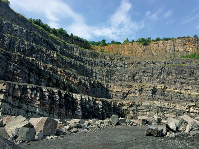
Layers of Late Triassic siltstone, subsequently contact-metamorphosed to hornfels during the Early Jurassic, are exposed in the walls of this Culpeper Basin stone quarry west of Washington, D.C. Credit: Ken Rasmussen.
After their uplift in the Paleozoic, the Appalachian Mountains began succumbing to erosion, the byproducts of which formed the vast sedimentary blanket of the Atlantic Coastal Plain. We know little about this time of mountain-lowering directly from the rocks of D.C. But in the Virginia Piedmont to the west, the Culpeper Basin and other Triassic-to-Jurassic-aged rift basins record the continental stretching that kicked off the breakup of Pangea and the opening of the Atlantic Ocean — a process that continues to this day at the Mid-Atlantic Ridge. These rift basins, still visible as lowlands from Nova Scotia to Mexico, are hallmarks of East Coast geology. Over roughly 45 million years, the basins filled with clastic sediments that provided the material for 19th-century brownstone buildings constructed up and down the Eastern Seaboard, including the Smithsonian Institution Building (commonly known as the Castle) in D.C.
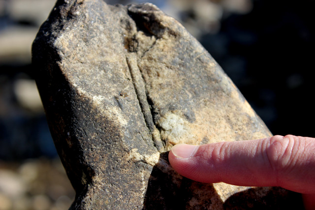
This quartzite clast from the Potomac Formation, the oldest exposed sedimentary layer in the upper reaches of the Coastal Plain, preserves trace fossil remains, called Skolithos, of late Cambrian burrowing organisms. Credit: Ken Rasmussen.
Continuing erosion and subsidence of the Appalachians brought the ancient crystalline bedrock foundations near what’s now D.C. to about sea level by roughly 125 million to 100 million years ago. At the same time, rivers dumped gravel, sand, silt and clay atop the eroded mountain roots. The Potomac Formation represents the oldest sedimentary layer visible in the upper, western reaches of the Coastal Plain. Gravelly remnants of the lower portions of the Potomac Formation form the high ground west of Old Town in Alexandria. A great place to see this is at Fort Ward, one of the best preserved of the region’s fortified Civil War-era defenses. Quartzite clasts found in Cretaceous fluvial deposits there contain beautifully preserved trace fossil remains (Skolithos) of late Cambrian burrowing organisms. These worm burrows were originally formed in Iapetan beach sands, which crop out today in the Blue Ridge.
The Potomac Formation is separated from the underlying hard rock of the Piedmont by a glaring unconformity (more specifically, a nonconformity) representing at least 360 million years of missing time. The nonconformity is broken in several places in D.C. by small-offset thrust faults, including at the intersection of Adams Mill Road and Clydesdale Place in Northwest D.C., where schists metamorphosed in the Late Ordovician are thrust atop Cretaceous or younger river gravels. Similar thrusts visible in parts of Anacostia in Southeast D.C. cut through Miocene sediments. These are intriguing features because the region hasn’t been subjected to large-scale tectonic compression since the closure of the Iapetus about 250 million years ago. The trace of the fault was also found in excavations during construction of the D.C. Metro’s red line beneath Lafayette Park, immediately north of the White House, and it’s likely that the trace of that fault extends underneath the White House lawn.
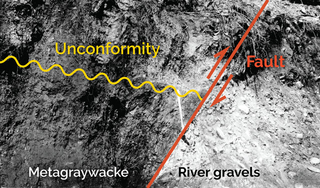
A nonconformity representing 360 million years of missing time is broken in several places in D.C. by small thrust faults, placing older metamorphic rocks on top of Cretaceous or younger river gravels. This example, originally photographed in 1920, can still be viewed today at the intersection of Adams Mill Road and Clydesdale Place, NW. Credit: USGS/N.H. Darton, annotated by K. Cantner, AGI.
About 50 kilometers south of Alexandria lie the weakly lithified, feldspar-rich alluvial sands of the Cretaceous Aquia Creek Sandstone. This easily extracted and carved rock earned the nickname Virginia Freestone among local stonemasons. And in 1791, Pierre Charles L’Enfant, the French-American engineer and architect hired by George Washington to design Washington, chose the stone to construct the city’s first buildings — the Capitol and the White House. It was also used for the boundary stones that outlined the city’s original diamond-shaped footprint. The once-bustling Aquia quarry can be viewed on the trails of what is now a historic nature preserve and archaeological site — the Public Quarry at Government Island in Aquia, Virginia.
To the east of the city, the sedimentary blanket of the Coastal Plain thickens, forming a layer cake of mostly unlithified material. Within this province, the gently dipping strata segue from Cretaceous in age to younger material of the Paleogene and Neogene. It is into these weak layers that rivers such as the Potomac and the Susquehanna sliced deeply during glacial epochs when sea levels were lower, forming what would become the Chesapeake Bay when seas rose again in the Holocene.
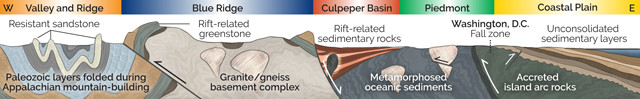
A conceptualized geologic cross section of the Washington, D.C., region, from the Valley and Ridge province to the west of the city to the Coastal Plain and Chesapeake Bay to the east. Credit: K. Cantner, AGI/Callan Bentley.
A significant portion of D.C.’s urban geology is artificially emplaced, moved there as part of reclamation and building efforts largely completed by the end of the 19th century. This includes a large tongue of rock and sediment used to build up and stabilize areas downtown, including around what are now the Washington Monument, the Lincoln Memorial and the Tidal Basin — generally known as West Potomac Park. But in the early 1790s when the first two buildings in the Federal City — the Capitol and the White House — were built, the western end of the National Mall was little more than swampy marshland along the Potomac. With mostly low-lying Coastal Plain topography available to L’Enfant, he placed the Capitol highest atop a 27-meter-high Late Pleistocene river terrace called the Wicomico Terrace, while the White House was built on a younger river terrace, the 15-meter-high Talbot Terrace. These hills are natural physiographic features of the landscape, unlike the built-up hill that supports the Washington Monument.
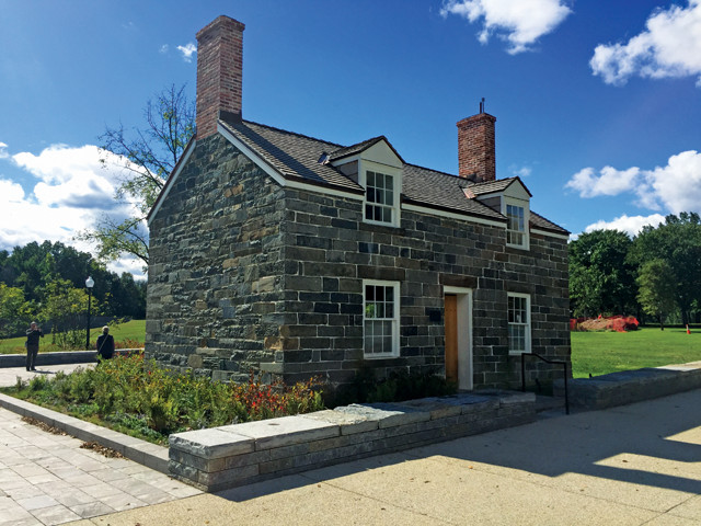
The Lockkeeper's House, seen here in its present location 10 meters from Constitution Avenue after being moved in 2017, was built in 1833 using local rock called Potomac Bluestone. Credit: Ken Rasmussen.
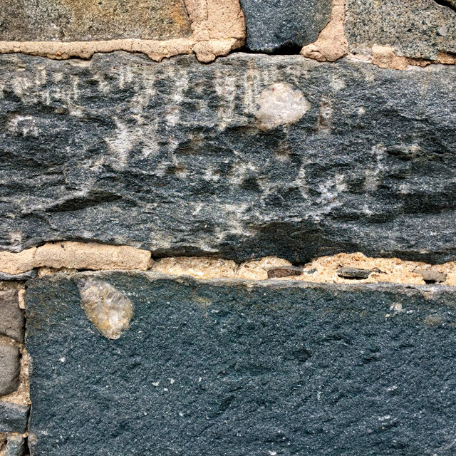
The Potomac Bluestone used on the Lockkeeper's house is a jumble of metamorphosed sediments, bearing both original quartz pebbles and metamorphic garnets. Credit: Ken Rasmussen.
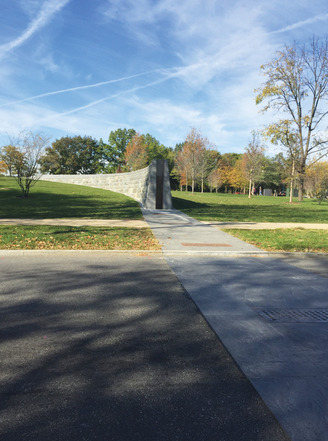
A levee consisting of stone bulwarks on either side of 17th Street in Northwest D.C. was completed in 2014 to keep floodwaters from inundating the National Mall. Upon emergency orders from the National Park Service, aluminum panels can be quickly inserted into the gap between the bulwarks. Credit: Ken Rasmussen.
The National Mall is replete with many architecturally and historically significant structures made with a variety of locally sourced, interesting rocks. The Lockkeeper’s House, located at the southwest corner of 17th Street and Constitution Avenue in Northwest D.C., was built in 1833, when the Washington City Canal flowed where traffic-congested Constitution Avenue now does. The canal, itself built along the former Tiber Creek and opened in 1815, joined the Potomac to the Anacostia River and serviced the commerce and construction of the growing city. From 1835 to 1855, the little stone building was home to the lockkeeper who manned the connection of the Washington City Canal to a southern extension of the C&O Canal called the Washington Branch, collecting tolls, keeping records of commerce, and helping raise or lower cargo-carrying boats in the lock. In 2017, the building was moved 10 meters from Constitution Avenue to give it some relief from 21st-century traffic. A close look at the recently renovated exterior reveals that most of the stone is local metamorphics: glittering Piedmont schists and gneisses, known locally as Potomac Bluestone, which hold garnets and deformed quartz pebbles like those seen in the Sykesville Formation.
After viewing the Lockkeeper’s House, look south and you’ll see a recently constructed levee, nicknamed the Wall on the Mall, spanning 17th Street. Since the 1790s, high waters flowing down the Potomac have flooded the Mall many times, and with the increasing likelihood of stronger, lingering storms and higher storm surges moving up the tidal Potomac, plus ongoing land subsidence, flooding is expected to get worse. The levee, built in 2014, is designed to hold back floodwaters reaching roughly 5.5 meters above present sea level at this site, the National Mall’s lowest unprotected lip. Blocks of mostly greenstone and diabase make up the fixed stonework of the levee on either side of the street, leaving a 43-meter-wide gap across the roadway. Upon emergency orders from the National Park Service, aluminum panels would be quickly inserted into the gap to block floodwaters.
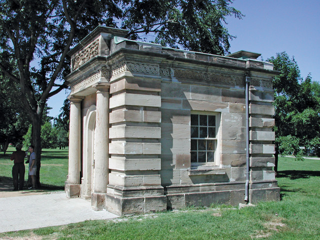
This gatehouse at 17th Street and Constitution Avenue — and a second two blocks down the road — were built in 1828 and originally located outside the Capitol building before being relocated to their present locations in 1880. Like the Capitol and the White House, the gatehouses were constructed from local Aquia Creek Sandstone. Credit: Ken Rasmussen.
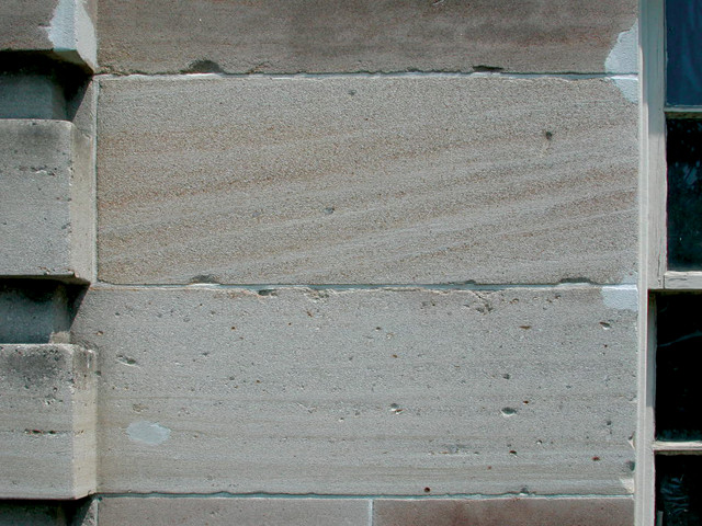
Close inspection of the gatehouses, and a trio of similarly fashioned gateposts at 15th Street and Constitution, reveal depositional textures in the rock, as well as the effects of nearly two centuries of weathering. Credit: Ken Rasmussen.
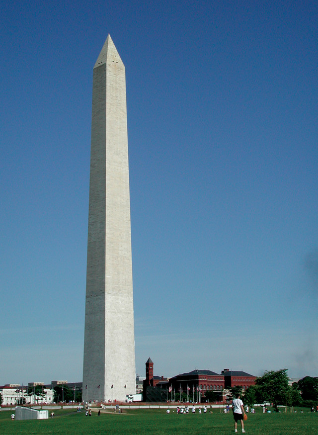
Construction of the 169-meter-tall Washington Monument began in 1848 with marble quarried from Texas, Md., but stalled in 1854 when funding ran dry. When construction resumed in 1876, the U.S. Army Corps of Engineers briefly used marble from a quarry in western Massachusetts, then completed the stonework in 1884 with marble from a different Maryland source. The changes resulted in two distinct demarcations in the color of the obelisk, which became visible upon subsequent weathering. Credit: Ken Rasmussen.
Before departing the intersection of 17th and Constitution, have a look at the small sandstone building diagonally across from the Lockkeeper’s House. This is one of two remaining Capitol Gatehouses, designed by the famous 19th-century landscape architect Charles Bulfinch and built with Aquia Creek Sandstone quarried from Government Island. (The other is two blocks down Constitution Avenue at 15th Street.) These beautiful little buildings were built in 1828, but not in their present locations; like displaced bits of crust accreted to the East Coast, these structures were relocated in 1880 from their original positions near the Capitol.
The gatehouses and their associated Capitol Gateposts — three of which stand at the intersection of 15th Street and Constitution Avenue — were part of a wrought-iron fence system constructed around the Capitol grounds, primarily to keep out grazing livestock. Look closely to see the rust-highlighted cross-bedding and textural variations in the sandstone blocks of these structures that attest to the fluctuating directions and energies of Cretaceous river currents. The rusty tint is inherited from the iron-rich Piedmont rocks that were the source of the sediments in this sandstone.
A combination of a wet and warm climate, poorly cemented and chemically unstable arkosic sand in the rock, and the wear and tear of the urban environment has taken a toll on these spalling relics. Soon after it was used to build the White House, Capitol and the gatehouses, the Aquia Creek Sandstone was eschewed as an exterior building stone in favor of more durable alternatives.
South of Constitution between 15th and 17th streets, the high-standing marble edifice of the Washington Monument is difficult to miss. Nearby, a diminutive granite block, known as the Jefferson Pier, marks the location originally chosen for the monument in 1804 based on the Masonic sensibilities of landscape symmetry and geometric design shared by L’Enfant and Jefferson. When construction began in 1848, the ground proved too squishy, so a more stable site was selected about 120 meters up the grassy slope to the southeast of the granite pier. However, the final site still did not offer enough support for what would become the 91,000-ton load of the completed monument, so Potomac Bluestone blocks quarried nearby were used to shore up the foundation before construction began. The original foundation was further widened and reinforced with cement buttresses in 1876, and, once covered, these helped create the artificially high perch on which the iconic D.C. obelisk now sits.
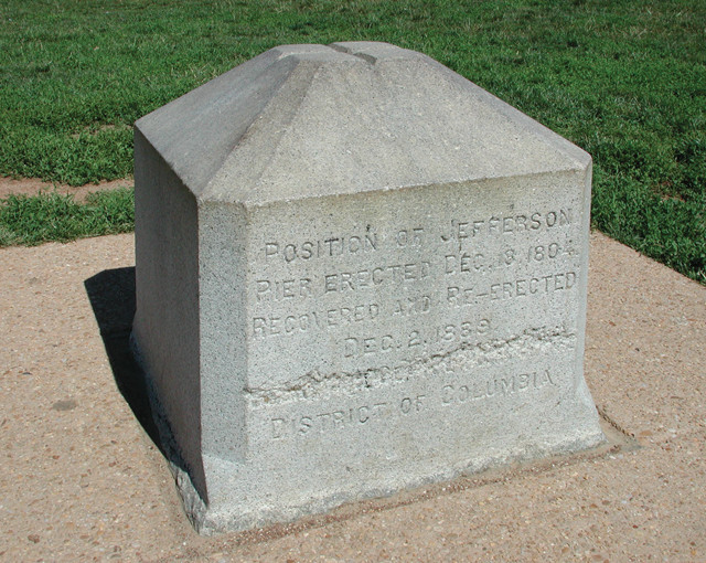
The Jefferson Pier marks the spot that Thomas Jefferson originally designated as the site of the Washington Monument in 1804. The monument's actual location is about 120 meters to the southeast. A replacement stone cut from durable Mississippian Petersburg Granite was erected in 1889 after the original pier, made of Virginia freestone, was removed in the 1870s. Credit: Ken Rasmussen.
The color change about 48 meters up indicates where construction stopped for two decades around the time of the Civil War. The private donations that funded the monument’s initial construction ran out by 1854, and when the U.S. Army Corps of Engineers resumed construction in 1876, the original marble was no longer available. A subtle change in lithology marks the transition from calcitic Texas marble (mined in Texas, Md.) at the base to a few courses of marble (also calcitic) from Lee, Mass. When timely and consistent delivery of Lee marble proved elusive, the upper two-thirds or so was finally finished with dolomitic marble quarried in Cockeysville, Md., about 3 kilometers from the source of the original Texas marble. The stonework was completed in 1884. Recent renovations are ongoing due to both the wear and tear from weathering and the lingering effects of shaking from the magnitude-5.8 Mineral, Va., earthquake on Aug. 23, 2011. The monument suffered substantial damage to its marble blocks, especially near the pointed top, or pyramidion. The strong shaking from this earthquake — the most widely felt seismic event in U.S. history — also damaged the Indiana Limestone pinnacles and flying buttresses of Washington National Cathedral in Northwest D.C., as well as the brownstone turrets of the Smithsonian Castle.
The Smithsonian Institution Building, better known as the Castle, was completed in 1855 using sandstone from about 40 kilometers up the Potomac River. The red coloration appeared after the rock was quarried due to iron oxidation. . Credit: Leandro Neumann Ciuffo, CC BY 2.0.
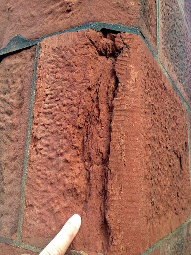
The sandstone was chosen partly for its durability, although weathering has taken its toll over time, resulting in spalling and pitting, particularly in blocks near the building's base and corners Credit: Ken Rasmussen.
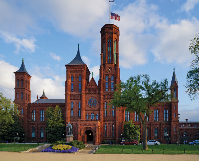
The unmistakable profile of the Smithsonian Castle, the first building among the Smithsonian Institution’s array of museums and galleries in D.C., sits on the south side of the National Mall between the Washington Monument and the Capitol. Designed in a fanciful Gothic Revival style by architect James Renwick Jr., and completed in 1855, this building housed all the offices, labs, lecture halls and specimens of the entire Smithsonian Institution through 1881. It was constructed of Late Triassic Culpeper Basin sandstone that was extracted from cliffs near Seneca Creek in Maryland — about 40 kilometers up the Potomac from downtown D.C. — and then transported to the city via the C&O and Washington City Canals. The stone was chosen for its low cost, proximity and ease of transport, and its pleasing, warm gray lilac color. The distinctive deep-red “brownstone” color seen today was produced through oxidation of iron in the sandstone after it was quarried; this oxidation apparently also promoted the rock’s hardening over time. Although the stone was considered durable, even waterproof, at the time of its selection, a close look now suggests this was not an entirely accurate forecast: Considerable spalling, water retention and biological growth is evident, especially in blocks near the building’s foundation and corners. The Castle’s slate roof is also noteworthy: It was preceded by a wooden original that caught fire in 1865, just 10 years after the building’s dedication. The fire tragically destroyed much of the Castle’s early, irreplaceable contents and nearly consumed the whole structure.
If you’re in D.C., whether for the AGU meeting this December or for other reasons, it’ll be well worth your time to explore some of the region’s rocky scenery — in environs both natural and built. Walks in the parks, local field excursions and touring the National Mall offer stirring prompts to contemplate the depth and diversity of our nation’s geologic underpinnings.
© 2008-2021. All rights reserved. Any copying, redistribution or retransmission of any of the contents of this service without the expressed written permission of the American Geosciences Institute is expressly prohibited. Click here for all copyright requests.