
by Terri Cook and Lon Abbott Thursday, June 22, 2017
Named for its location at the confluence of two major rivers, Grand Junction, western Colorado’s largest community, is a laid-back city of 60,000. About 50 kilometers from the Utah border, the city is surrounded by tremendous geographic diversity straddling two spectacular landscapes: the classic slickrock sandstone of the American Southwest and the Rocky Mountains’ snow-capped peaks.
To the east of town, the basalt-capped Grand Mesa, the world’s largest flat-topped mountain, looms above the fertile floodplains of the Colorado and Gunnison rivers. To the north, the tawny Book Cliffs, home to galloping herds of wild horses, rise above vineyard-dotted terraces. To the west, the bent sandstone layers of Colorado National Monument soar just above adobe-style houses. To the south lie two beautiful — and very different — canyons waiting to be explored. And all around the area you can find the remains of dinosaurs — both fossils and footprints. Whichever direction you choose, it’s hard to go wrong around Grand Junction if stunning natural scenery and outdoor exploration are in your wheelhouse.
“From its headwaters high in the Rockies, the Colorado River swells with frigid snowmelt each spring. Its first major tributary is the Gunnison, which joins the main stem in Grand Valley, the wide vale that hosts Grand Junction. Historically, the portion of the Colorado River above its junction with the Green River in Utah was called the Grand River, which is the reason there are so many “Grand” place names in western Colorado. But in 1921, a U.S. representative from Colorado successfully petitioned a congressional committee to rename this key river after its state of origin, whose name, which means “red-colored” in Spanish, is appropriate for its often-muddy appearance.
The Gunnison River joins the Colorado (formerly called the Grand) River in western Colorado's Grand Valley. Credit: Terri Cook and Lon Abbott.
Spanish explorers were the first non-natives to glimpse the Gunnison River, which they called the San Javier, in the late 1700s. Later explorers knew the river by a variety of names before the name Gunnison — which honors U.S. Army Captain John Gunnison, who was killed by Utes while surveying a trail — stuck in the 1880s.
Since its incorporation in 1882, Grand Junction has served as the economic anchor for the valley, whose fertile soils, comparatively mild climate and abundant irrigation water have made it Colorado’s fruit capital. Today, the peach, cherry, apricot and nectarine orchards planted by early settlers are slowly being supplanted by flourishing vineyards in the up-and-coming Grand Valley American Viticulture Area (AVA).
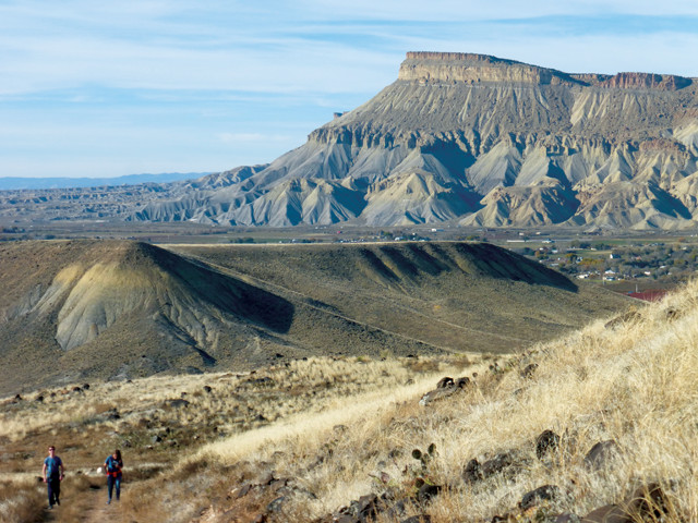
Basalt-capped Grand Mesa is the world's largest flat-topped mountain. Credit: Terri Cook and Lon Abbott.
The tale of the two rivers is best appreciated via a scenic drive to the top of the basalt-capped Grand Mesa, whose 1,300-square-kilometer area purportedly makes it the world’s largest flat-topped mountain. Its surface is dotted with beautiful alpine lakes and traversed by gentle hiking trails that wind through groves of aspen trees and lead to arresting views. The Lands End Observatory offers one such vista that you can drive to on a good gravel road.”
Because Grand Mesa rises 1,800 meters above Grand Valley, it would be natural to assume that it is the result of some great geologic upheaval. In this case, however, no such turmoil occurred. The dark rock at Lands End is a basalt lava flow that erupted 10.7 million years ago from dikes that are exposed farther east. Due to its low viscosity, basalt readily flows down toward the lowest topography, which, at the time of the eruption, was a river valley located where Grand Mesa stands today. This flow solidified into Grand Mesa’s hard cap. As rivers began to slice into the landscape, it was much easier for them to remove the surrounding, soft sedimentary rocks than the hard basalt. This difference in erosion gradually converted what had once been the lowest point in the landscape into the highest, a process known as “topographic inversion.”
The presence of rounded river cobbles beneath Grand Mesa’s basalt cap confirms that it was indeed a valley when the eruption occurred. Since some of these cobbles consist of granite and metamorphic rocks that could only have come from the Rocky Mountains to the east, they were most likely deposited by the ancestral Colorado River. At the time of the basalt flow, the ancestral Colorado flowed at an elevation 1,500 meters above that of the modern river. This means the Colorado has been down-cutting at an average rate of 140 meters per million years since the eruption.
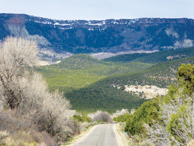
“The Colorado River enters Grand Valley through DeBeque Canyon, which the powerful river has carved between Grand Mesa and the Roan Plateau. Although the same geologic strata make up both features, because the Roan Plateau isn’t capped by basalt, it has eroded much more quickly and now stands about 500 meters lower than Grand Mesa.
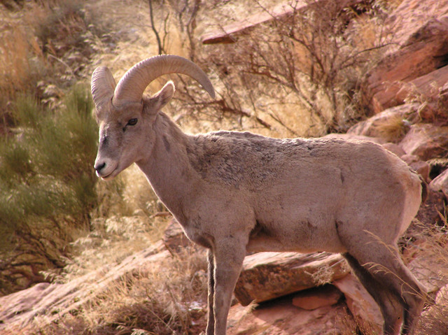
Desert bighorn sheep are common along the Colorado National Monument's beautiful trails. Credit: Terri Cook and Lon Abbott.
The top layer in the plateau’s sedimentary stack is the Green River Formation, which was deposited about 55 million years ago in a chain of lakes comparable in size to the modern Great Lakes. Periodically, when the lake water became stagnant, oxygen levels plummeted, allowing huge quantities of organic matter to be preserved. This was later converted into oil shale. Some of the darkest shale contains so much trapped oil that you can actually light the rock on fire. Although the Roan Plateau’s shale is thought to contain as much oil as exists in the Middle East, it is prohibitively expensive, as well as environmentally problematic, to extract.
The Roan Plateau is also famous for its herds of wild horses, which were officially protected by the 1971 Wild and Free-Roaming Horse and Burro Act as “living symbols of the historic and pioneer spirit of the west.” Some of America’s largest herds roam free across this vast tableland. Although there is never any guarantee that you’ll see the wild horses, one of the best places to look is the Little Book Cliffs Wild Horse Range, located just 13 kilometers northeast of Grand Junction. Even if you don’t spot any, a hike or horseback ride through either Coal Canyon or Main Canyon is still a fun adventure.
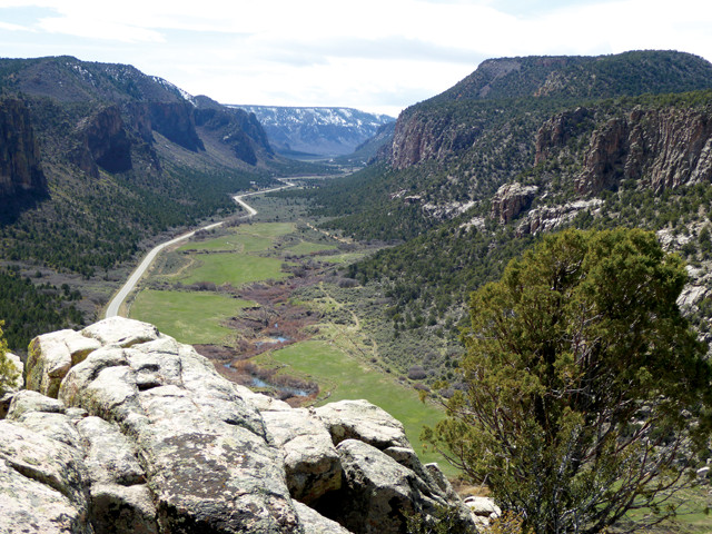
South of Grand Junction, Unaweep Canyon was probably carved by the Gunnison or the Colorado but abandoned when its water source was diverted by stream piracy. Credit: Terri Cook and Lon Abbott.
In contrast to Grand Mesa’s dark cap, Colorado National Monument hosts the same red slickrock sandstone as Moab and other iconic southern Utah destinations. The monument’s stack of colorful, Mesozoic sedimentary rocks blanket underlying Precambrian granite and metamorphic rocks riddled by ancient faults. Although such faults often appear extinct, they merely lie dormant, ready to be awakened during the next tectonic episode if conditions are favorable.
That is precisely what happened to Grand Valley’s Redlands Fault, which awoke from its slumber about 65 million years ago during the Laramide Orogeny, the mountain-building episode that raised Colorado’s Rocky Mountains. Slow motion along the fault gradually buckled the overlying stack of sedimentary layers, raising the ones on the west above those to the east. The result was a one-sided fold, akin to a strip of carpet bent over a stair riser, that geologists call a monocline.
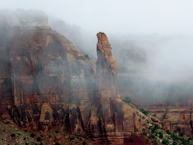
A misty morning in Colorado National Monument. Credit: Terri Cook and Lon Abbott.
Over time, streams have carved precipitous, sandstone-rimmed canyons into this monocline, in places re-exposing the dark metamorphic rocks. The national monument’s extensive trail system explores the ups and downs of the monocline. One of the best hikes is the 8-kilometer-roundtrip route to an impressive sandstone pillar called Independence Monument. If you instead prefer to cycle or drive, the monument’s spectacular Rim Rock Drive ascends the monocline, passes many gorgeous viewpoints along its crest and then descends the lopsided fold to return to Grand Valley.
Just outside the monument lie badlands composed of rocks from the Jurassic-aged Morrison Formation. This area comprises Grand Junction’s dinosaur country. You can tour the badlands and delve into dinosaur lore on two short interpretive hikes, one just 800 meters long at the Fruita Paleontological Area, and the other a 2.4-kilometer trail at Dinosaur Hill. You can also tour the exhibits at the Dinosaur Journey Museum, an attraction along the Dinosaur Diamond sightseeing route. Among the excellent exhibits is a fossil of the 70-centimeter-long Fruitadens, the second-smallest dinosaur ever found, which is named for the nearby town of Fruita, where it was discovered.
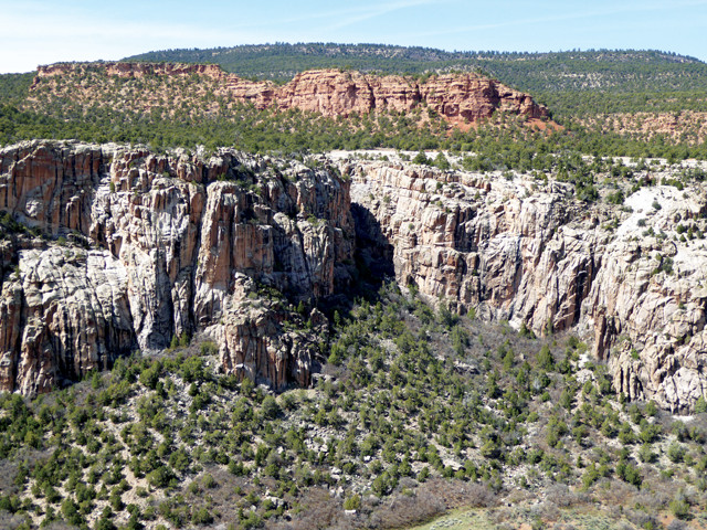
The walls of Unaweep Canyon consist of Precambrian granite overlain by Mesozoic sedimentary redbeds. This major time gap between the units forms the Great Unconformity. Credit: Terri Cook and Lon Abbott.
“Unaweep Canyon, located 48 kilometers south of Colorado National Monument, is unusual in that, unlike most canyons, it doesn’t mark the landscape’s lowest point. Instead, it cuts laterally across the crest of the Uncompahgre Plateau (the southern part of the same regional uplift that raised Colorado National Monument), exposing red Mesozoic sandstone as well as hard, underlying Precambrian granite. Unaweep means “canyon with two mouths” in the native Ute language, an appropriate name since it is drained by two tiny creeks, one flowing out each end.
Because Unaweep is so broad and deep, geologists think that either the powerful Colorado or the Gunnison carved this canyon, but that the river was later forced to abandon it following an act of “stream piracy.” This geologic crime occurred when a stream flowing through Grand Valley’s soft rock stealthily eroded its way up the valley before intersecting the larger river and spiriting away Unaweep’s water, leaving its canyon high and dry. With Unaweep Canyon robbed of almost all its water, erosion of its floor all but ceased, leaving it stranded ever higher above the still-eroding Grand Valley.
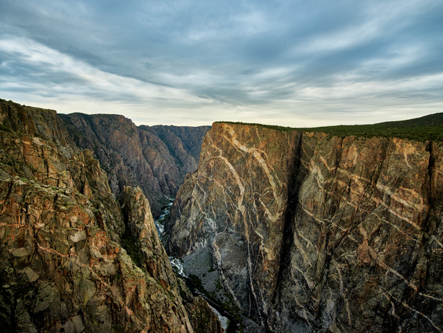
At 685 meters, the granite and gneiss Painted Wall in Black Canyon of the Gunnison National Park is the highest cliff in Colorado. Credit: Carol M. Highsmith Archive, Library of Congress.
As erosion progressively lowered Grand Valley, the Gunnison River upstream of Grand Junction was forced to keep pace. In the process, the Gunnison encountered a dome of the same hard, Precambrian granite and gneiss exposed in Unaweep Canyon and Colorado National Monument. The small notch that the Gunnison carved into these hard rocks acted like a guide groove for a saw, trapping the river and forcing it to carve the spectacular Black Canyon.
Although it is neither the deepest nor the longest gorge in the West, “no other canyon in North America combines the depth, narrowness, sheerness and somber countenance of the Black Canyon of the Gunnison,” wrote geologist Wallace Hansen in his book, “The Black Canyon of the Gunnison: In Depth.” In places, the canyon is deep enough to swallow Chicago’s 442-meter-tall Willis Tower and so narrow that the river receives only minutes of sunlight each day. These deep shadows, plus the dark hue of the canyon’s metamorphic rocks, gave it its name. The gorge’s 20 most spectacular kilometers are preserved within the Black Canyon of the Gunnison National Park, located 120 kilometers from Grand Junction, where rock climbing, as well as hiking, cycling and cross-country skiing along the rim, are all popular activities.
Several river terrace deposits that stand high above the modern Gunnison contain a distinct layer of volcanic ash that erupted 640,000 years ago from the Yellowstone Caldera. The presence of these deposits has allowed geologists to calculate that the Gunnison has been cutting the Black Canyon at a rate of 640 meters per million years — 4.5 times faster than the long-term average rate at Grand Mesa.
Be sure to leave enough time during your visit to sample fare produced along both of Grand Junction’s rivers. Chief among the local products is wine. Much like the Rhone River in southern France, the Colorado in Grand Valley is flanked by a series of gravelly, well-drained terraces that host more than 20 wineries. Many are linked with other regional attractions, such as fruit stands and lavender groves, to create the Palisade Fruit & Wine Byway.
A relaxed place to sample the local bounty is Carlson Vineyards. One of the state’s oldest wineries, Carlson is noteworthy for its Tyrannosaurus Red, which was served at the Chicago Field Museum’s unveiling ceremony for Sue, the largest and most complete Tyrannosaurus rex skeleton ever found. The winery’s fermented pear-and-apple wine, Pearadactyl, continues the dinosaur theme.
Vineyards also line the bucolic valley of the Gunnison River’s North Fork, just over an hour’s drive from Grand Junction. There, in the smaller West Elks AVA, a gorgeous area tucked beneath the eroded volcanoes of the West Elk mountains, several family-owned wineries offer great places to taste the AVA’s distinctive terroir.
The Grand Junction region is an outdoor enthusiast’s paradise, with excellent rock climbing, mountain biking and hiking, plus angling and whitewater rafting on both the Colorado and Gunnison rivers. One of the most hard-core activities is cycling the Kokopelli Trail, a 230-kilometer “bikepacking” route from Loma, Colo., to Moab, Utah, that crosses through some of the Southwest’s most stunning high desert scenery. For those with less time or energy, there are also many shorter trails to explore by bike or by foot.
Whether you’ve spent a fun-filled day in Grand Valley quenching your thirst at an award-winning vineyard, or pumping the pedals along a slickrock mountain-biking trail — at the end of it, be sure to tip your glass to the streams, both ancient and modern, that carved one of Colorado’s most spectacular landscapes.
© 2008-2021. All rights reserved. Any copying, redistribution or retransmission of any of the contents of this service without the expressed written permission of the American Geosciences Institute is expressly prohibited. Click here for all copyright requests.