
by Brian Fisher Johnson Thursday, January 5, 2012
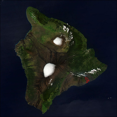
The Big Island of Hawaii, with two snow-topped peaks: Mauna Loa, to the south, and Mauna Kea, to the north. NASA Earth Observatory
For a bit of money, visitors to Hawaii can indulge their touristy impulses with a single night of mai tais and luaus. But take on Hawaii’s geologic hallmarks, and you’ll embark on a low-cost safari that will last you all week.
Hawaii is the name of both the state and the largest island in its archipelago. The “Big Island” began forming around 700,000 years ago as part of the Hawaiian-Emperor seamount chain, a vast underwater range of mountains that extends from the Emperor seamounts near Russia to the Big Island itself. This trail of volcanic mountains formed over a period of 70 million years, as the Pacific Plate glided northwest over a stationary hotspot (an upwelling of Earth’s molten mantle). The state’s more northerly islands, including Oahu and Maui, were part of this chain but have since shifted away from their magmatic source, while the newest addition to the chain, Hawaii, remains volcanically active.
Visitors can see this activity first-hand at Volcanoes National Park in the southeast quarter of the island, just 32 kilometers from the city of Hilo on the east coast. Once at the park, visitors can’t miss Hawaii’s most famous volcanoes: Mauna Loa and Kilauea.
Coming from either direction, travelers will encounter Mauna Loa long before they enter the park. The broad, gently-sloping volcano, whose name means “Long Mountain,” was built by thousands of accumulated lava flows and stretches the entire width of Hawaii, and at 17,000 meters above the seafloor, is the largest such "shield" volcano in the world. In fact, if the entirety of Mount Everest were placed on the Pacific seafloor next to Mauna Loa, Mauna Loa would tower over Everest by more than 8,150 meters! Drivers will barely sense the rising elevation as they approach the summit, but make no mistake: Mauna Loa’s history is anything but gentle. Eruptions during the 20th century destroyed many homes, and lava flows remain a threat to Hilo, whose very ground is formed from the lava.
Inside the park visitors can easily spot Mauna Loa’s snow-topped peak. Experienced mountain climbers can elect to backpack the 4,170-meter-high slope and spend a night at the “summit cabin” next to Mauna Loa’s Mokuaweoweo caldera — a flat-bottomed depression that resulted from gas released during eruptions. Be prepared with plenty of food, first aid and warm clothes, though, as the elevation, blizzards and high winds can put hikers at risk of altitude sickness and hypothermia.
Even a perfect day is not without strain: As one hiker wrote in the Summit Cabin log, “Perfect weather, great sunset and sunrise. Glad to have done it but wonder if the last seven miles [11 kilometers] from the summit trail junction really were only 2.1 [miles or 3.4 kilometers]!”
Visitors looking for a more accessible look at Hawaii’s volcanic system should visit Mount Kilauea. While not as high Mauna Loa (1,277 meters), Kilauea is one of the most active volcanoes on Earth. Its three-kilometer-wide, five-kilometer-long caldera, located right at the entrance of the park, visibly emits steam in some places. It produced a mild explosion in March, emitting enough sulfur dioxide and debris to close Crater Rim Drive, which rings the caldera. For a good intro to the local volcanology, stop by the visitor center at the park entrance before driving out . Once on Crater Rim, visitors can hike down into the caldera.
The eastern half of Crater Rim Drive connects to the Chain of Craters Road. Take a detour here for a brief hike along Devastation Trail, which derives its name from the destruction wielded by the 1959 eruption of the nearby Kilauea Iki Crater. The jaunt offers a perfect opportunity for collecting Pele’s tears, wind-quenched lava drops named in honor of Pele, the Hawaiian god thought to live in Kilauea. Take any tears at your own risk: Legend has it that Pele will curse anyone who removes rock from Hawaii until it is returned (the myth’s sketchy origins, however, have led some to believe it is a creation of park rangers).
Also on the east half of Crater Rim Drive is the trail leading to the Thurston Lava Tube, a former underground channel of molten rock leading to the ocean. A shady walk through a fern tree forest precedes the tube entrance, dotted by the red pompom blossoms of the ohia tree. The flower’s gentle appearance belies the hardy nature of the tree. Among the first colonizers of lava-devastated areas, the leaves of these trees are so nutrient-poor that it can take years for bacteria to decompose them. The Tube itself is surprisingly roomy, with lights brightening the short walk to the other end. With a walkway wide enough to accommodate several people, it’s a wonder the Tube wasn’t discovered until 1913 — not by a geologist, but by a local newspaper publisher who lent the Tube his name.
Volcano National Park is not the only highlight of Hawaii’s geology. Outside the park, at the southernmost portion of the island, is Papakolea Beach, one of only two greensand beaches in the U.S. (the other is in Guam). The olivine crystals from which the beach derives its color are piled within the amphitheatre-like remnants of a seaside cinder cone. While the origin of the beach remains a point of contention, it is known that other crystals, such as black pyroxenes, had also populated the shore, but olivine, being heavier, has resisted erosion by the beach’s crashing waves. A quick scoop of the sand with bare hands demonstrates olivine’s density. Be glad the beach exists within your lifetime: Olivine may be heavy, but its formation at high pressures and high temperatures makes it less stable at earth’s surface. In just hundreds of years the green sand will disintegrate. Getting to the beach requires a hike to and down the rough cinder cone, so avoid wearing flip flops.
Punaluu Beach Park is another must-see beach. A picturesque black sand beach, it was formed by the breaking up of basalt flows. Keep a look out for green sea turtles, which often come ashore to bask. Just be sure to keep your distance, as touching the turtles could give them diseases to which they have no immunity.
Before leaving the beach, take a good look at the ocean to the southeast. No one will see it for thousands of years, but as the Pacific Plate continues to move to the northwest, new seamounts will form. Many will remain underwater. But one day, as the magma within the hotspot rises upward to the surface, a dab of lava will breach the waves, and another, hopefully equally beautiful, island will be born.
© 2008-2021. All rights reserved. Any copying, redistribution or retransmission of any of the contents of this service without the expressed written permission of the American Geosciences Institute is expressly prohibited. Click here for all copyright requests.