
by Terri Cook and Lon Abbott Wednesday, August 16, 2017
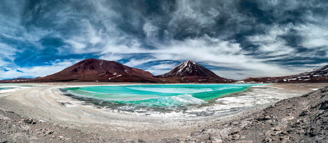
Green Lagoon (Laguna Verde) is a highly concentrated salt lake located in the southwest of the Eduardo Avaroa Andean Fauna National Reserve at the foot of the Licancabur Volcano, Sur Lipez Province, Bolivia. The green-turquoise color of the water is due to suspension of arsenic and other minerals. Credit: ©iStockphoto.com/thomaslusth.
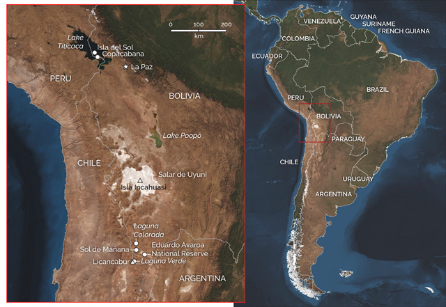
Nestled between two ranges of the rugged Andes Mountains, the Altiplano is a vast, windswept plateau that stretches more than 900 kilometers from southern Peru to northern Argentina. Most of this arid upland, which averages about 3,750 meters in elevation, sits in western Bolivia, where its surface is dotted with a series of stunning natural attractions. From the snow-white crystals of the world’s largest salt flats and flocks of pink flamingos in a brick-red lake to the startlingly azure waters of Lake Titicaca, the planet’s highest navigable lake, the Altiplano offers spectacular, vividly colored vistas for intrepid travelers. You could easily spend a month exploring this region, or get a tantalizing, week-long taste as part of a bigger South American journey, as we did in 2016, when we started in Peru and ended in Patagonia.
“The Altiplano is sandwiched between the western and eastern chains of the Andes Mountains. The eastern chain is called the Cordillera Real. The Andes are the classic example used in introductory geology classes to illustrate how subduction of an oceanic tectonic plate beneath a continental plate forms mountains. But that Geology 101 explanation fails to account for the Altiplano’s lofty elevation, which is the subject of vigorous debate.
The Bolivian Altiplano is sandwiched between the western and eastern chains of the Andes Mountains. Credit: both: K. Cantner, AGI.
The high topography of most mountain ranges and plateaus is supported by extra-thick continental crust. Where two plates converge, the crust is shortened by stacking one slab of crust atop another along a thrust fault, thereby thickening it. The 70-kilometer-thick crust beneath the Altiplano is among the thickest on Earth. But geologists have only been able to document about 120 kilometers of crustal shortening along the northern Altiplano’s thrust faults — about half the amount necessary to produce crust that thick. Some additional mechanism must have been at work here. One leading hypothesis is that as thrust faulting thickened and heated the crust beneath the adjacent Andes, the lower crust began to flow toward the Altiplano like taffy, thickening the crust there and providing the additional buoyancy needed to raise the plateau so high.
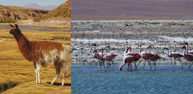
Despite the extreme aridity and high elevation, herds of llamas and flocks of flamingos thrive on the Altiplano. Credit: both: Terri Cook and Lon Abbott.
“But even crustal flow isn’t enough to completely explain the Altiplano’s great height. To obtain a more complete picture of the Altiplano’s uplift history, geologists have employed a variety of paleoaltimeters, such as oxygen isotopes, clumped carbon and oxygen isotopes, and analysis of fossil leaf shapes. Oxygen isotopes become lighter at higher elevation, and the degree to which the heavy isotopes of carbon and oxygen clump together is a function of temperature, which varies with altitude. Temperature also dictates the percentage of tree leaves that have jagged versus smooth edges. The results indicate that the southern Altiplano rose first, between about 16 million and 9 million years ago, followed by the central Altiplano between about 10 million and 6 million years ago. The northern Altiplano, by contrast, reached its current 4,000-meter elevation just 5 million years ago. What’s more, the entire plateau rose after the time of maximum plate compression, which occurred between about 50 million and 20 million years ago. If the Geology 101 explanation were correct, then the timing of the uplift should match this period of maximum compression.
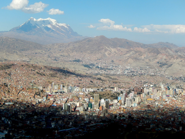
Illimani, the tallest peak in the Andes' Cordillera Real, looms over La Paz, the highest capital city in the world. Credit: Terri Cook and Lon Abbott.
The leading alternative hypothesis attributes the rise of the Altiplano to a different mechanism: the detachment and sinking of a blob of dense mantle lithosphere from the bottom of the South American Plate. The lithosphere consists of the entire crust and the coldest, most rigid upper portion of the mantle. Below about 100 to 200 kilometers depth, the mantle is hot enough to flow slowly, like taffy, where it is called the asthenosphere. The lithospheric mantle and the asthenosphere are compositionally identical, but the lithosphere is colder, which makes it denser. So if a piece of it becomes detached, it will sink into the asthenosphere. Such a “lithospheric drip” is then replaced by hotter, more buoyant asthenosphere, which causes the plateau to rise like a ship that rides higher in the water when its cargo is unloaded.
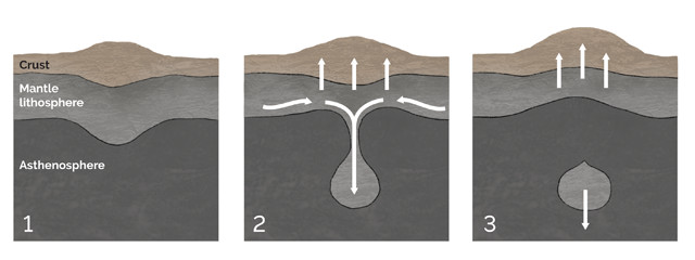
One hypothesis for the height of the Altiplano attributes the rise of the plateau to the detachment and sinking of a blob (or "drip") of dense mantle lithosphere from the bottom of the South American Plate about 16 million years ago , which then caused the overlying crust and remaining lithosphere to rebound and rise. As the colder, denser lithospheric drip sank into the asthenosphere beneath the southern Altiplano, the lithosphere beneath the central Altiplano was destabilized, which, in turn, triggered a similar drip beneath the northern Altiplano. This scenario, which neatly explains many otherwise-perplexing characteristics of the Altiplano's geologic history, is supported by recent tomographic imagery of a blob of cold, dense lithosphere that is sinking beneath the plateau. Credit: K. Cantner, AGI.
Proponents of this hypothesis suggest that about 16 million years ago, a blob of lower lithosphere beneath the southern Altiplano started to drip. This set off a chain reaction, first destabilizing the lithosphere beneath the central Altiplano, which, in turn, triggered a similar drip beneath the northern Altiplano. This scenario, which neatly explains many otherwise-perplexing characteristics of the Altiplano’s geologic history, is supported by recent tomographic imagery of a blob of cold, dense lithosphere that is sinking beneath the plateau.
“Located near the Altiplano’s northern edge and straddling the border between Bolivia and Peru, Lake Titicaca is South America’s largest lake, both by surface area and volume. The sparkling, snowcapped peaks of the Cordillera Real mountains reflected in the brilliant blue water are breathtaking sights, both figuratively, thanks to the high-altitude lighting, and literally, because of the very thin air here at 3,800 meters elevation.
During the last 8,000 years, the Lake Titicaca Basin has been home to numerous civilizations whose legends have gradually melded. According to the myths of the Tiwanaku, who controlled the area during much of the first millennium A.D., as well as the Inca, who conquered this region in the 15th century, Lake Titicaca is the center of the cosmos and the origin of their civilizations. They also considered the sapphire waters to be the birthplace of the sun, moon and stars, all of which a creator god fashioned from islands in the lake.
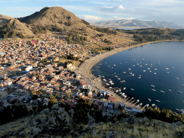
Once the location of a significant Incan sanctuary, Copacabana is now the main Bolivian tourist town on beautiful Lake Titicaca. Credit: Terri Cook and Lon Abbott.
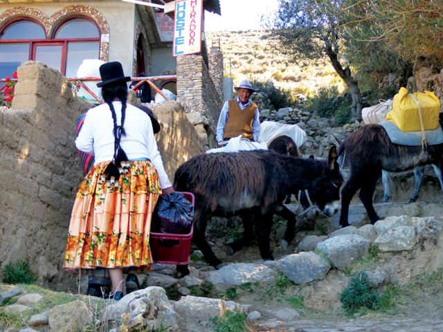
The sun purportedly emerged from a crag on Isla del Sol, Titicaca’s largest isle, which you can easily visit via a ferry or tour from Copacabana, the main Bolivian tourist town on the lake and the site of another important Incan sanctuary. A great way to explore this revered island is to take a morning ferry from the Copacabana beach to the indigenous community of Cha’llapampa on the island’s northern end and then follow one of the walking paths to a steep stone stairway — the Escalera del Inca — in the south, arriving in time for the return ferry.
About 800 indigenous families live on Isla del Sol, which you can explore via a network of walking paths once used by the Inca. Credit: Terri Cook and Lon Abbott.
There ’re two main hiking paths on the island: a coastal route that wanders through villages flanke’ by sandy beaches and deep-blue bays, and a more challenging central ridge path. Either route provides marvelous views of’the lake, the tilted sedimentary rocks that comprise the island, and the snowcapped cordillera to the west. If you choose th’ ridge route, a short detour near the island’s northern tip leads to the Incan ruins at Chincana, where the main attraction is a labyrinth of crumbling walls and short doorways that shroud a sacred well. Just southeast of the ruins is a table believed to have been the site of various sacrifices.
If you’re acclimated to the altitude, either walk should take about three to four hours; if not, it’d be best to spend the night to avoid potentially missing the last ferry. If you want ample time to explore the ruins, it’s best to spend a night or two on the island. Either way, be sure to bring plenty of sunscreen and water (the parched island’s main source, the Fuente del Inca, is located in the south).
“On Bolivia’s southern Altiplano, another superlative high-altitude attraction awaits: the Salar de Uyuni, the world’s largest salt flats. In stark contrast to Titicaca’s cobalt waters, the salar’s salt-encrusted surface, which covers more than 10,000 square kilometers, is blindingly white. Trips across the saltpan are an adventure because of the difficult driving on the playa’s often-slippery surface and the lack of features to orient you. For safety, tour Jeeps travel together in caravans. After departing the frontier town of Uyuni, the tours visit a graveyard of rusted train cars and locomotives before striking out across the salt flats.
The pancake-flat salar is all that remains of paleo-Lake Tauca, which covered as much as 80,000 square kilometers of the Altiplano between about 18,500 and 8,500 years ago. Each time our jeep tour reached the edge of the salar, we saw Lake Tauca’s ancient shorelines, which stand tens of meters above the salt flat’s current 3,656-meter-high surface. The salar itself is a salt crust several meters thick, composed mostly of halite and gypsum, which overlies young volcanic rocks. Those volcanics comprise a mostly buried ridge that occasionally protrudes above the salt crust to form a series of cacti-covered islands that appear, thanks to mirages, to float above the salty surface. Best known is Isla Incahuasi, which nearly every tour visits. Here we slowly huffed and puffed for about 15 minutes up to the island’s highest point — about 30 meters above the salar surface — for views of the vast, crystalline surface sparkling beneath the brilliant sunlight.
The salar is one of Bolivia’s most important mineral resources. In addition to being a source of salt, which has been mined here since the 16th century, and ulexite, a fibrous boron mineral used in fertilizers (which is also known as “TV stone” because of how it conducts light), the salar is one of Earth’s largest sources of lithium, the lightest metal. Lithium is a crucial component of the lithium-ion batteries that power cordless tools, electric vehicles and portable electronics, including cellphones, laptops and cameras. The U.S. Geological Survey estimates that the Salar de Uyuni hosts 5.5 million tons of lithium, or roughly half the world’s reserves.
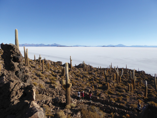
The highest parts of a mostly buried volcanic ridge form several islands that protrude above the vast Salar de Uyuni. Credit: Terri Cook and Lon Abbott.
“The sheer isolation, as well as the vast flatness of the Salar de Uyuni, became evident to us when our guide stopped in the middle of the salt flats to help our group take forced-perspective photos. Our kids loved staging images of optical illusions that made themselves look larger — and their sibling look smaller — and find fun angles to make it appear that they were holding the other in the palm of one hand. The adults’ favorite part of the tour came in the evening, as we watched the setting sun bathe the sparkling salt in ethereal yellow, pink and blue light that seemed to illuminate each hexagonal salt tile. Once the sun set and the temperature plummeted, we were grateful to arrive at our cozy “hotel” made from blocks of salt.
During the second day of the three-day Salar de Uyuni tours, the jeep caravans leave the salt behind to climb even higher up into the arid Andes en route to the Chilean border. Tucked between towering volcanoes and quinoa fields, a few small villages pepper this harshly beautiful and extremely remote landscape. The highlight here is the Eduardo Avaroa Andean Fauna National Reserve, a 714,000-hectare reserve set aside to protect dozens of species of birds, including three hardy species of endemic flamingos.
“The reserve is best known for its colorful lakes, including the Laguna Colorada, whose vivid red color comes from algae and contrasts sharply with the blue sky, white borax deposits in and around the lake, and — if you’re lucky enough to see them — dozens of pink flamingos strutting in the very shallow water. Another dramatic scene awaits visitors to the reserve’s Laguna Verde, where a teal-green lake — whose hue comes from its high concentrations of carbonates combined with dissolved heavy metals, including copper, arsenic and lead — sits beneath the classic cone of 5,868-meter-tall Licancabur Volcano.
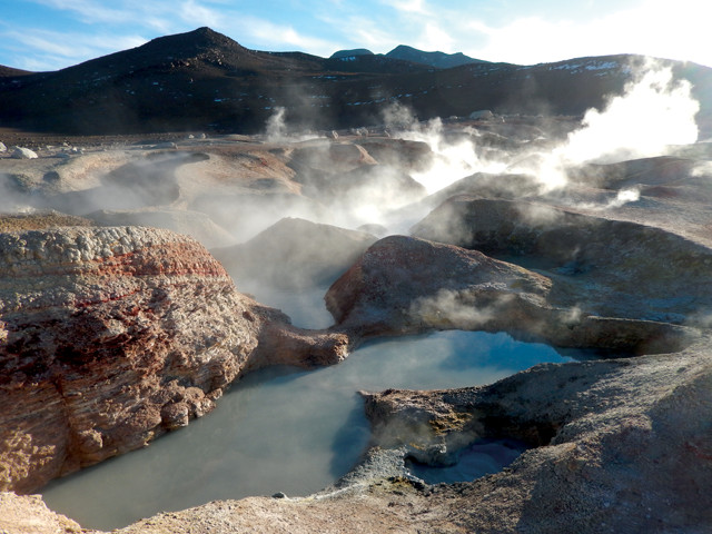
The Sol de Mañana geothermal field, which has boiling mudpots and fumaroles but no geysers, is among the highest geothermal fields on Earth. Credit: Terri Cook and Lon Abbott.
Also nearby are two other attractions: the Stone Tree, a rock that has been carved by wind into a treelike shape reminiscent of a Dr. Seuss illustration, and the Sol de Mañana geothermal field, where you can wander among boiling mud pots and steaming fumaroles. The clouds of steam and smell of sulfur, along with the 4,850-meter-high elevation and lack of any safety features, only add to the surreal feeling of sky-high adventure in this spectacular part of the Andes.
© 2008-2021. All rights reserved. Any copying, redistribution or retransmission of any of the contents of this service without the expressed written permission of the American Geosciences Institute is expressly prohibited. Click here for all copyright requests.