
by Lucas Joel Friday, January 22, 2016
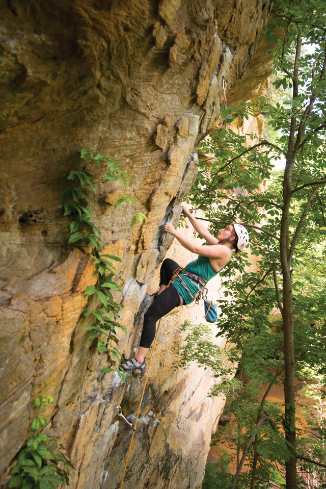
A climber hangs from plate-like sandstone protrusions at the Pendergrass- Murray Recreational Preserve. Credit: Alex Mandrila.
One Friday last June, some friends and I drove five hours from Ann Arbor, Mich., to Kentucky’s Red River Gorge, a natural scenic area also called “the Red.” By the time we hit Dayton, Ohio, rain clacked against the car windows, and lightning flashed. We continued on, and at about 2 a.m., southeast of Lexington, Ky., we turned onto Highway 11, part of the Red River Gorge Scenic Byway. This 75-kilometer stretch along Highways 11, 715 and 77 loops visitors through the Red River Gorge Geological Area in Daniel Boone National Forest — which features more than 100 natural sandstone arches — as well as Natural Bridge State Resort Park and the Clifty Wilderness.
We continued southeast along the Middle Fork Red River to Miguel’s Pizza, housed in a yellow wooden building with fields behind it for camping. There were only a few tents around ours, but in the fall and spring the place can be full. The rain had passed, and thousands of fireflies flickered in the trees.
We went to the gorge intending to spend the weekend hiking and rock climbing — the two most popular activities in this natural spectacle — as well as admiring the rocks. The sandstone there is typically coarse, which helps hands grip and shoes stick while climbing. The Early Pennsylvanian sediment (323 million to 315 million years old) that makes up the sandstone eroded from the ancient Appalachian Mountains, which were once maybe as tall as the Himalayas are today.
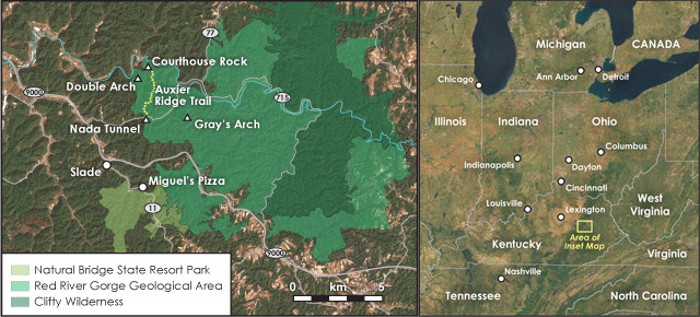
The Red River Gorge is southeast of Lexington, Ky. Visitors need a car to get around. Credit: both: K. Cantner, AGI.
Thousands of people visit the gorge each year, far less than the number who head to the sandstone arches and red rock gorges of Utah and Arizona. People don’t often think of Kentucky as a destination to see these dramatic features. But maybe they should.
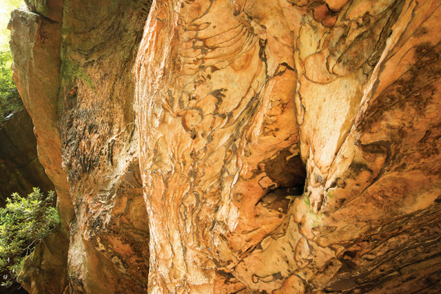
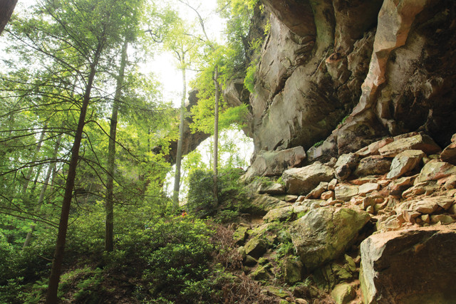
Liesegang banding is preserved in the side of a cliff near Gray's Arch. Credit: Alex Mandrila.
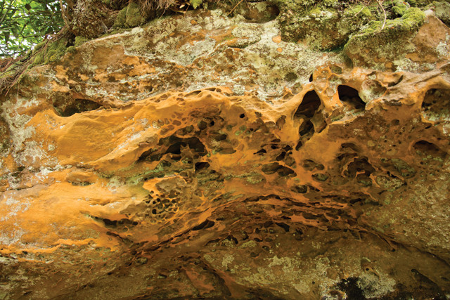
Iron-oxide-rich sandstone is seen on the way to Gray's Arch. Credit: Alex Mandrila.
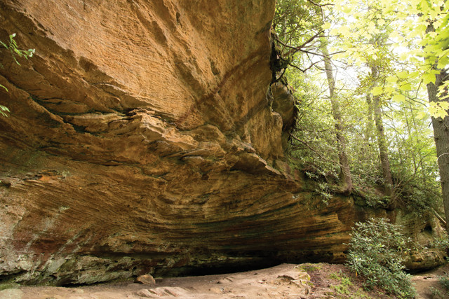
Overhung strata cover portions of Gray's Arch Trail. Credit: Alex Mandrila.
The Red is heavily forested, and the rocks are often hidden behind trees. The first part of the trail to Gray’s Arch, however, follows a ridge from which you can see sandstone cliffs far to the left across a ravine. The strata here, as they are throughout the Red, are horizontal, and the rock is cemented and mostly undeformed. Rock layers are generally massive, and the quartz arenite sandstone can range from fine- to coarse-grained and even conglomeritic. The sandstone is part of the Early Pennsylvanian Corbin Sandstone Member, which, depending on how eroded and incised it is, ranges from 30 to 85 meters thick. The formation often preserves planar and trough crossbedding, and was likely deposited in a braided river system.
Closer to Gray’s Arch, more outcrops emerge, some containing pebbles. The rock can be iron-rich and orange to red in places, which is what gives the region’s Red River its name. Liesegang banding — swirling bands of iron-rich minerals in rock — is common and can contain hematite and limonite deposits. Before you reach Gray’s Arch, you climb down two steep sets of wooden stairs to a gully. Cliffs loom above, and large boulders rest at the bottom amid pink and red dust. One side of one cliff displays extensive, swirling Liesegang bands. The bands are sinuous and protrude from nonbanded portions of the wall.
Far above the boulders is Gray’s Arch. As we stood under the arch, we noticed rusty metal bolts hanging on one wall about 6 meters above the ground. These bolts were once used for rock climbing; a climber would clip gear to the bolt, clip a rope to the gear, and climb to the next bolt. Climbing arches is no longer allowed in the Red, though, due to their fragility.
Recent research suggests that sandstone arches, like those in the Red and elsewhere, such as Arches National Park, are stabilized as the surrounding rock erodes. Increased gravitational stress on the remaining sand grains cements and locks them more tightly together. In arches that have collapsed, the sandstone typically disintegrates easily due to the absence of gravity-induced stability.
Gray's Arch. Credit: Alex Mandrila.
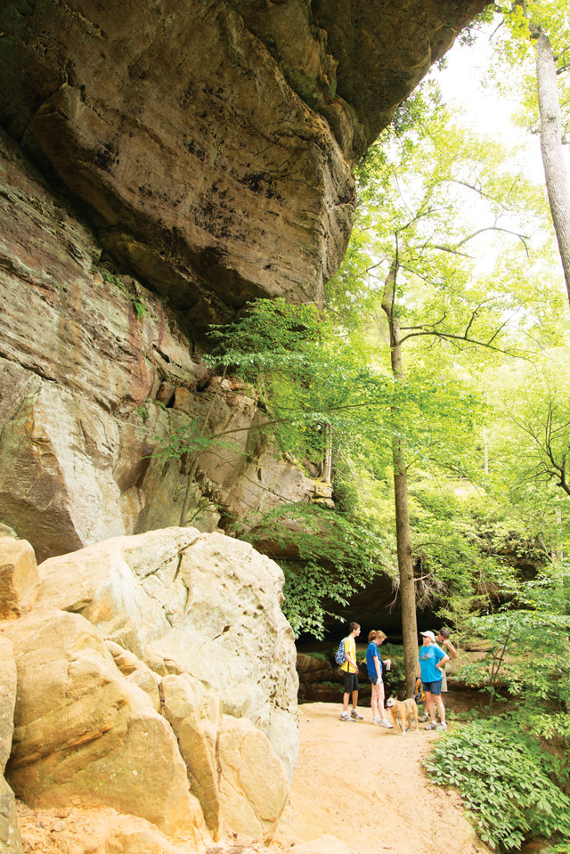
Standing under Gray's Arch. Credit: Alex Mandrila.
The gorges of the Red River Gorge Geological Area began forming after the region uplifted about 600 meters above sea level roughly 285 million years ago during the Permian — a process that formed the Cumberland Plateau from Alabama to western New York — and waterways then cut into preexisting vertical fractures in the Corbin Sandstone.
The Red River continues to incise the local stratigraphy, and today cuts below the Corbin Sandstone and into the Nancy Member, a siltstone and shale layer laid down in the Early and Mid-Mississippian (359 million to 331 million years ago). Its fine-grained character, as well as the presence of the marine trace fossil Zoophycos, indicates the Nancy Member was deposited in a low-energy, deep marine setting.
The Auxier Ridge Trail, northeast of Gray’s Arch, has stunning cliff-top views of a gorge carved by the Auxier Branch of the Red River. The trail has few trees and it can get quite hot in the summer, so be sure to bring water. There are slopes and hills, but the trail is not steep. We passed an outcrop with herringbone cross-stratification, which forms in tidal settings; some researchers suggest part of the top of the Corbin Sandstone was deposited in estuarine settings.
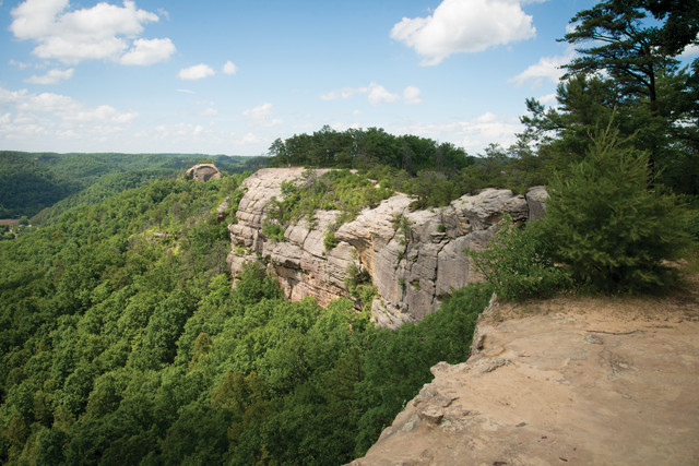
A view of Courthouse Rock (the dome left of the main cliff) from the Auxier Ridge Trail. Credit: Alex Mandrila.
Herringbone cross-stratification is preserved in this outcrop on the Auxier Ridge Trail. Credit: Alex Mandrila.
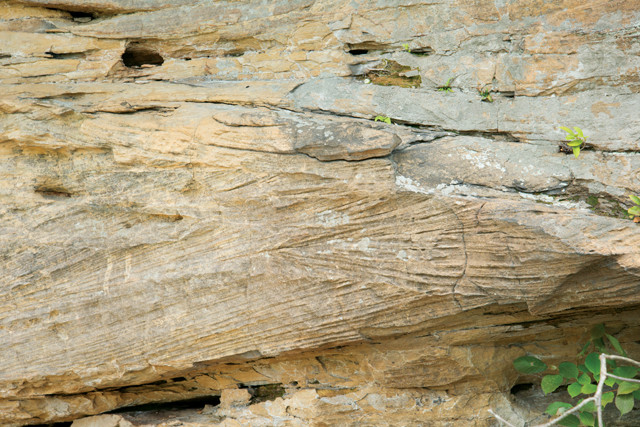
Erosional features on the cliff face at the Pendergrass- Murray Recreational Preserve make good handholds and anchorages for rock climbers. Credit: both: Alex Mandrila.
The trail reaches a viewpoint above tall cliffs where visitors can see Double Arch, a squarish two-layer arch, the lower layer of which is formed by a single rock stratum, as well as Courthouse Rock, a tall dome-shaped monolith with flat sides and a round top.
We drove through the town of Slade to go rock climbing on a well-known wall called Phantasia, just past Nada Tunnel, a 300-meter-long one-way tunnel that was used by logging trains in the early 1900s. Now on the National Register of Historic Places, it is known as the gateway to the Red. As you drive through it, more than 30 meters of the Corbin Sandstone lie above you.
At Phantasia, we climbed a 25-meter-high route called Pogue Ethics. (The names climbers give walls and routes are sometimes as mysterious as those given to racehorses.) The base of Pogue Ethics is an eroded rock shelter, and the first holds are pockets in the sandstone. Moderate cementation has helped weathering processes form these durable pockets, making them useful for climbing. Halfway up the climb, Liesegang bands protrude from the cliff face, forming additional holds. Here, as well as across much of the Corbin Sandstone, cementation of the sandstone varies vertically; sandstone closer to cliff tops is generally better cemented than rock near the cliff bottoms. This contributes to the cliffs’ characteristically overhung shape, with the tops protruding out farther than the bases.
Climbers are often rockhounds; after all, they depend on the rocks for their lives. “Whenever you come across a hold [while climbing] that feels just right, it’s like, ‘Huh, it took thousands of years for that [hold] to form just like that, just so I could have fun in that moment,’” a fellow climber, Drew Vechell, told me.
The next day, we drove south about a half-hour from our campground to the Pendergrass-Murray Recreational Preserve (PMRP), a remote cliff area only accessible via steep dirt roads (an all-wheel drive vehicle is best here) where there is good climbing. The Red River Gorge Climbers’ Coalition recently purchased 300 hectares at PMRP to secure access to climbing routes.
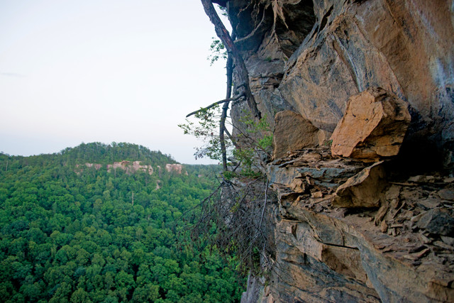
The top of the Party Time climbing route offers gorgeous views of the surrounding landscape. Credit: Alex Mandrila.
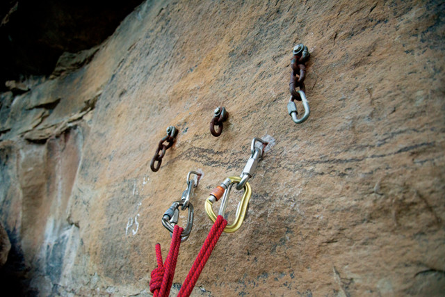
Climbing bolts in sandstone at the top of Party Time route at Fortress Wall. Credit: Alex Mandrila.
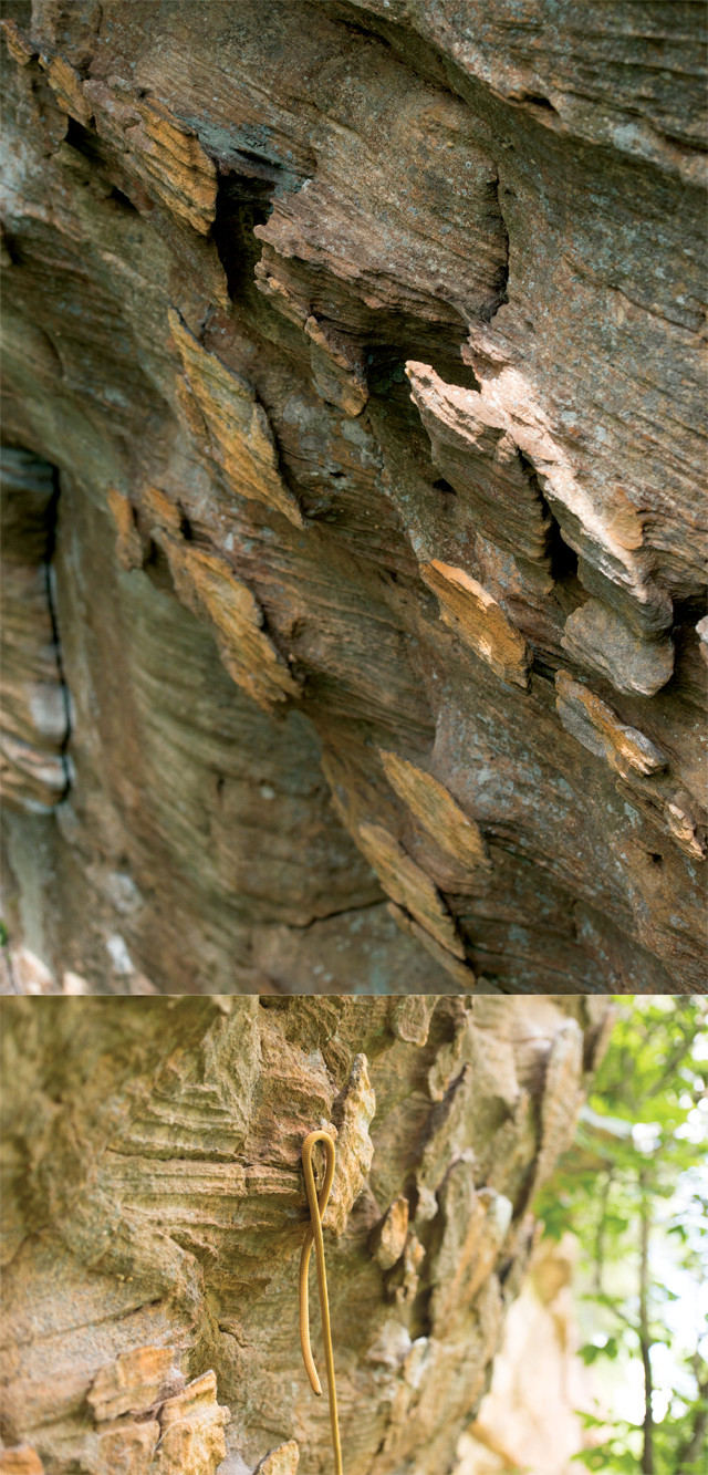
The PMRP cliff we visited is called the Gallery, which features opportunities mostly for “sport climbing” (see sidebar). Trees shaded the cliff face, which has plate-like rock protrusions extending outward. The edges of these plates are rounded, making for good holds.
<“iv>”"
“My favorite [type of hold] is when the rocks are shaped [weathered out] like motorcycle handlebars,” said Nathan Webster, a climber from Louisville, Ky., who was at the Gallery that day with his climbing partner, Jesse Amundsen of Cincinnati. “It’s like when there’s a hole in the rock [around a vertical hand grip in the wall] that you can pass your finger through and put a sling around it if you had to,” Amundsen added. “That’s a handlebar.”
The cliff at the Gallery has pockets and handlebars in the rock to the left, but to the right the rock gets flatter and has more plates. One of my companions climbed pockets on a route called 27 Years of Climbing. Another rappelled down a plate-filled route called A Brief History of Climb. Behind her was meter-tall planar crossbedding in the rock. After PMRP, we drove north back through Nada Tunnel to Fortress Wall and a vertical fracture, or crack, called Party Time. Vertical fractures like Party Time do not occur everywhere at the Red, but they are the zones of weakness that help erosive agents like water carve gorges.
Once you get above the tree line at the Red — whether by hiking or climbing — the views stretch far and wide, and you can get a good sense of how different geologic processes have helped sculpt the landscape. The Red offers seemingly limitless opportunities for enjoying nature, and it is worth the time to visit.
© 2008-2021. All rights reserved. Any copying, redistribution or retransmission of any of the contents of this service without the expressed written permission of the American Geosciences Institute is expressly prohibited. Click here for all copyright requests.