
by Lucas Joel Tuesday, May 1, 2018
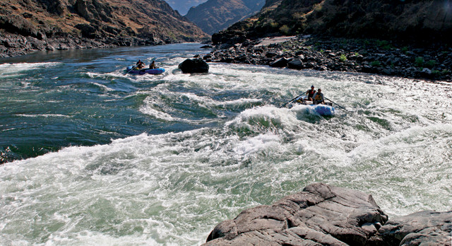
Rafting the Main Salmon River across Idaho offers a thrilling whitewater adventure, as well as a tour through several of the state's geologic provinces. Credit: Bureau of Land Management.
Give a river time and it will chart a path through even the mightiest mountains, cutting down through the rocky record of Earth’s long history. Rafting down a river, then, can give you a front-row seat to a geologic story that unfolds as you go past. Such is the case on a trip down the Main Salmon River, which courses first north and then west across northern Idaho over Precambrian metamorphic rocks, as well as granitic rocks of the Idaho Batholith, which intruded into the crust during the Cretaceous Period before being exposed at the surface. The finale of this Salmon trip — which takes about six to eight days to finish — arises as the river flows past what was once the edge of North America and over former island arcs sutured onto the continent during the Mesozoic.
I rafted the Main Salmon — also known as the River of No Return — in August 2017 after driving to Boise to meet up with my uncle, Bill Cross, a professional rafter, and his veteran crew of two: my aunt, Polly Greist, a writing teacher, and Michael Parker, a biologist. Bill is the kind of captain you want at the oars when the rowing gets tough, as the effortlessness with which he threads boats through rapids makes the ordeal look easy. It isn’t easy, of course, but Bill literally wrote the book on whitewater rafting in the western states: “Western Whitewater from the Rockies to the Pacific: A River Guide for Raft, Kayak, and Canoe.” He writes about rivers, and reads whitewater as well as you’re reading these words.
I went on the trip partly to practice rafting and fly-fishing. But I had another reason: I had to decide, after our trip ended, if I should pack up my life and move west, to California, or head back east to where I had been living in Michigan. Nature, I hoped, might help me make my decision.
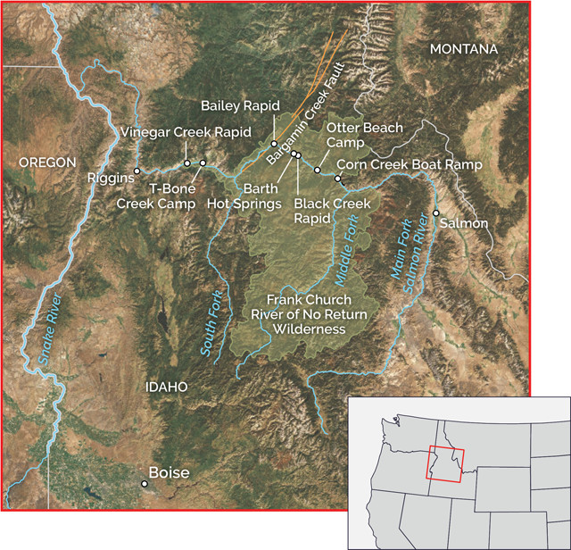
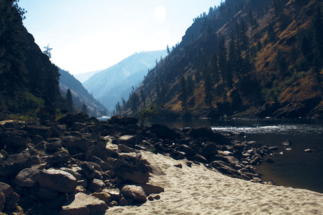
The Salmon River runs for about 680 kilometers, north from the mountains of south central Idaho and then westward, until it reaches its confluence with the Snake River along the Oregon border. The portion that most people raft flows through the U.S. Forest Service-administered Frank Church River of No Return Wilderness, from Corn Creek to Vinegar Creek. Credit: K. Cantner, AGI.
The Salmon River is the longest undammed river in the lower 48 states, and the longest river contained within a single state. The Salmon’s headwaters are in the mountains of south central Idaho, and the river runs about 680 kilometers until it reaches its confluence with the Snake River along the Oregon border. The portion of the Main Salmon that most people raft flows through the U.S. Forest Service (USFS)-administered Frank Church River of No Return Wilderness. But don’t worry: Though the name “River of No Return” sounds ominous, it refers to when, in the early 20th century, boaters used to transport hunting parties on one-way trips down the Main Salmon. Today, most rafters do not return to their launch site at the end of their trip, so the name still carries the same meaning.
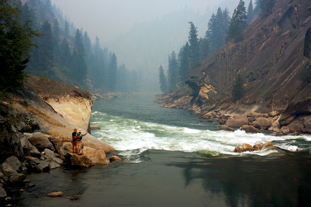
Most river trips down the Main Salmon begin at the boat ramp at Corn Creek Campground — about 75 kilometers west of North Fork, Idaho, by road — where rafters rig their crafts and have their gear and permit checked by a USFS ranger. There, we rigged our two rafts in the hot summer sun, and I readied myself for the unknown.
At Corn Creek, I saw the opening of our geologic tour: Precambrian metasedimentary rocks sticking out alongside the riverbanks and atop forested hills. This unit is part of the Belt Supergroup, a suite of rocks that crop out not just here, but elsewhere along the Salmon and in places like Glacier National Park. The supergroup formed about 1.4 billion years ago, though the exact timing of metamorphism is unclear, explains Reed Lewis, a research geologist with the Idaho Geological Survey, who was not on the trip. At least some of the deformation happened about 1.2 billion to 1 billion years ago during the Grenville Orogeny, when mountains rose along the eastern margin of proto-North America during assembly of the supercontinent Rodinia. Further deformation likely happened during the Cretaceous as the Idaho Batholith — which is farther downstream — intruded.
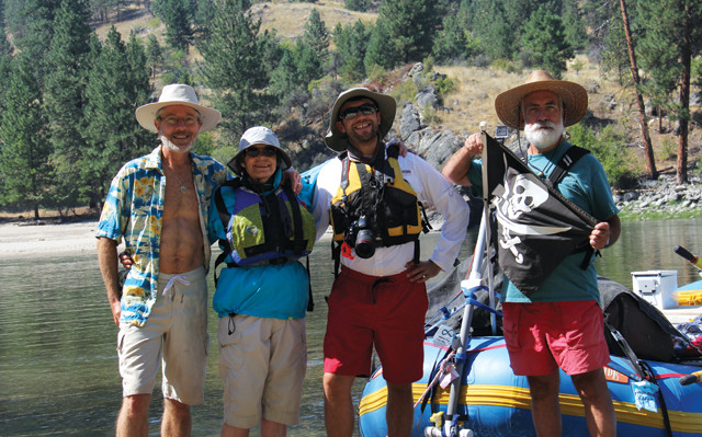
The author (third from left) poses with his fellow rafters — from left, Bill Cross, Polly Greist and Michael Parker — before embarking on their trip down the Main Salmon River in August 2017. Credit: Bill Cross
“Bill and I rowed in one of our two inflatable rafts to some rapids upstream of the Corn Creek Campground. He taught me how to ferry a boat through the rapids to the opposite side of the river — a tricky maneuver involving precise rowing, a perfectly-angled boat and many frantic over-the-shoulder glances. I aimed our boat at a rocky outcrop, where, after wrestling with rapids that spun me this way and that, we landed. I scrambled out and — indulging my inner rockhound — sampled some ancient, sparkling schists.
From Corn Creek the river briefly flows through rocks of the Belt Supergroup, but by the time we reached our first stop — Otter Beach Camp at mile 10.1 — we were already rafting over the Idaho Batholith. The first exposed rocks of the batholith that rafters see are Cretaceous metamorphic rocks that occur as foliated, black and white orthogneisses. In later stretches, batholith rocks retain their original crystalline character, appearing as salt-and-pepper granodiorites.
We assembled our cots on the white sands of Otter Beach, while across the quiet river stood a great, dead pine tree whose gnarled and naked limbs stretched outward. Suspended in the higher branches was a nest made of thick sticks, and perched near the nest were two bald eagles. Another rafting trip passed our camp, and we told the team to look up. As the team slowly floated by, we all watched the eagles as they peered back at us.
Around mile 18, the river slices through a kind of geologic island amid the batholith: granitic Eocene rocks of the Challis Magmatic Complex, which intruded into the much older batholith that surrounds it. Floating onward from the Eocene granites, we were enshrouded by smoke from some distant wildfire as we came upon Black Creek Rapid, just shy of mile 21.
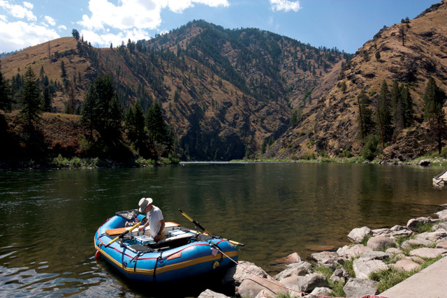
Cross prepares a raft before the group launches from Corn Creek Campground. Metamorphosed sedimentary rocks of the Precambrian Belt Supergroup underlie the landscape here, cropping out along the river and on the slopes above. Credit: Lucas Joel
There is nothing like having cold river water splash over you on a hot day. However, those splashes often come from wild rapids that can not only soak your clothes, but also flip your boat if you don’t navigate through them carefully. Rapids can form when rivers narrow, or when flowing water encounters sudden drop-offs in slope or obstacles like boulders plucked from the surrounding mountains. These things can create big waves and swirling eddies in fast-moving waters littered with exposed rocks — hence the need for experienced guides like Bill.
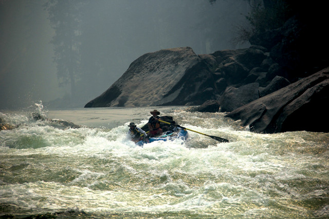
Black Creek Rapid, one of the toughest rapids on the Main Salmon, formed several years ago thanks to a debris flow that swept downstream from adjacent Black Creek, just about where you first encounter Challis Complex rocks. Above the rapids, the river is a quiet pool, but in no time the dark still water turns into white foam as the river drops down over boulders deposited by the debris flow. Cross and Parker (who can probably give you the scientific name of every plant and animal on the river) docked the boats just before the rapid, then climbed ashore to plot a course through the turbulent waters. Back in the boats, we floated downstream as the river narrowed into a dark tongue that took us into the white chaos.
At Black Creek Rapid, near where rafters first encounter granitic rocks of the Eocene Challis Complex, the calm that prevails immediately upstream suddenly turns to chaos as the river encounters a boulder field. Here, Parker and Cross scope out a path through the rapids from the shoreline. Credit: Lucas Joel.
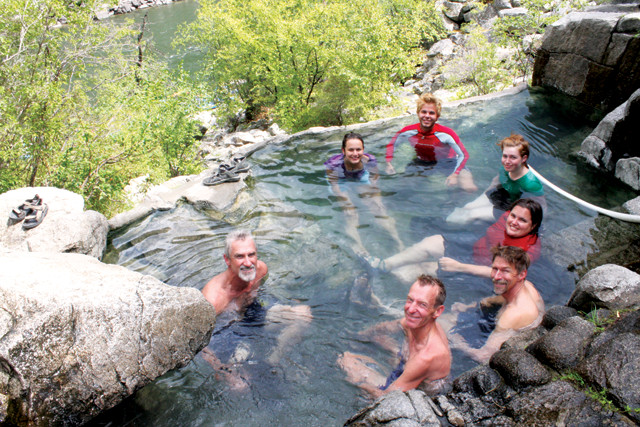
The views of Challis rocks don’t last long before the river takes you back into the batholith. At about mile 22, we passed by natural hot springs called Barth Hot Springs, which offer a warm respite from the cold rapids and hard rowing. You can park your boat on the left side of the river and make a short hike to the springs.
“If you go farther north in Idaho, hot springs decrease in number,” Lewis says. The source of warmth beneath the springs isn’t definitively known, but Lewis says the heat may arise from the same magmatic processes associated with crustal extension in the Basin and Range province to the south. The Basin and Range, perhaps the best known example of which is found in Nevada’s many linear, north-south-trending mountain ranges, extends all the way from Mexico to southern Oregon and Idaho. As the crust in this vast region pulls apart and thins, warm mantle rock rises closer to the surface, providing a source of geothermal heat across much of the West.
The author (left) and Parker descend into the maelstrom of Black Creek Rapid, one of the toughest stretches on the Main Salmon. Smoke from distant wildfires left a haze over the river during the trip. Credit: Bill Cross
Several miles downstream from the hot springs is Bailey Rapid, another monster: A boat just behind ours took a wrong turn amid the whitewater and their 4-meter raft, laden with gear, flipped amid the whitewater. Their gear was not secure, and much of it dumped into the river’s maw. We rescued a block of cheese for them, but little else.
Barth Hot Springs, a short hike from the river, offers a respite from cold rapids and hard rowing. Credit: Bill Cross
“The next big geologic scene change comes at about mile 32, soon after passing Bailey Rapid, with rafters’ arrival at the Bargamin Creek Fault — a northeast-trending normal fault that formed as the Challis Complex intruded. The fault is no longer active, but its effect on the river is clear from an eagle’s view: Instead of continuing northwest, the river turns sharply to the southwest and follows the trace of the fault, running mostly through Belt Supergroup rocks. “The fault is why the river takes a turn there,” Lewis says. “It’s coming along and it finds that nice soft rock made by the fault, and it follows sub-parallel to that structure for quite some distance.”
Cross surveys Bailey Rapid, where another raft flipped over in the water, spilling unsecured gear into the river. Just beyond Bailey Rapid, the river turns sharply to the southwest, following the trace of Bargamin Creek Fault. Credit: Lucas Joel.
“Then, as if the fault had never gotten in the way, the river resumes its northwest trajectory after the confluence with the South Fork of the Salmon River. Here, the granite of the batholith is yellowish, friable and unmetamorphosed, which makes it easier to see the unaltered grains in this rock with the naked eye compared to the batholith rocks seen before reaching the fault.
The eclipse obscured about 98 percent of the sun at Hungry Bar Camp along the Main Salmon, dimming the morning sunlight on an otherwise clear day. Credit: Bill Cross
Near mile 60 we laid over at Hungry Bar Camp. That night, I fly-fished from one of our boats, but the fish weren’t biting. Putting my rod aside, I spoke to my aunt Polly about the crossroads I was at and the choice I had to make about moving. We talked about the need to face life’s challenges — that hard things can help one grow. Our conversation helped me make my decision; I did not catch a fish that night, but I did gain some wisdom.
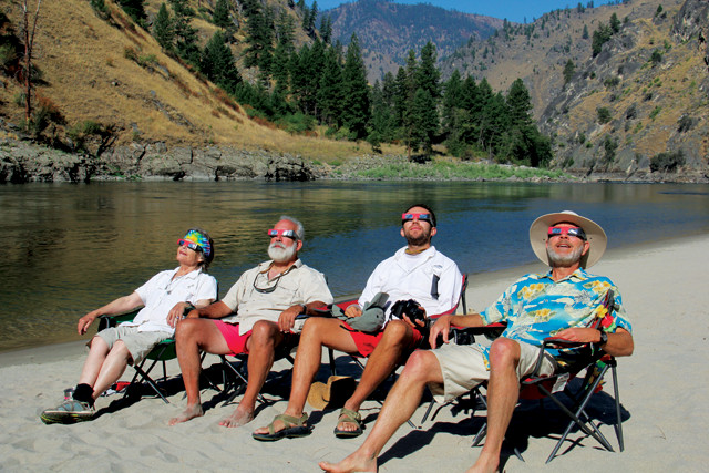
The group took in the solar eclipse on Aug. 21 from the comfort of Hungry Bar Camp. Credit: Bill Cross
The next morning, the sky was clear of clouds and smoke, and the sun hung above the mountains upriver from camp. It was Aug. 21, the day of the Great American Eclipse. Wearing our eclipse glasses, we looked straight at the sun as the moon slowly blocked more and more of its light. (We were just north of the path of totality, in an area where about 98 percent of the sun was obscured.) As the light grew dim and the air grew cool, birds stopped chirping for many minutes as the moon passed in front of the sun. I took off my glasses at one point and made a small hole with my thumb and forefinger, watching as the light poured through the hole and projected crescent-shaped images on the sand. A nearby tree had the same effect, projecting dozens of tiny images of the eclipse from light streaming through spaces between leaves.
“After the eclipse we resumed our trip on the river, floating past another strip of exposed Belt Supergroup metamorphics at about mile 70. If you stop over anywhere along this stretch of the river, I suggest staying at T-Bone Creek Camp (mile 71.3). T-Bone has a large beach that’s great for camping and activities like Frisbee or badminton. Large outcrops of micaceous schist surround the camp, and erosion of these rocks no doubt contributes to the lithology of the beach: When the sun hits the beach at the right angle, the abundant mica crystals glint like diamonds in the sand.
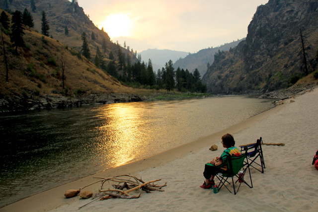
Greist takes in the evening view along the river. Credit: Bill Cross
" — another river trip filled with geologic delights.
We took our boats out at Carey Creek boat ramp at mile 80.7, just downstream from Vinegar Creek Rapid. From there we drove back to Boise, and, after saying our goodbyes, I got in my car and headed east.
© 2008-2021. All rights reserved. Any copying, redistribution or retransmission of any of the contents of this service without the expressed written permission of the American Geosciences Institute is expressly prohibited. Click here for all copyright requests.