
by Terri Cook and Lon Abbott Monday, January 11, 2016
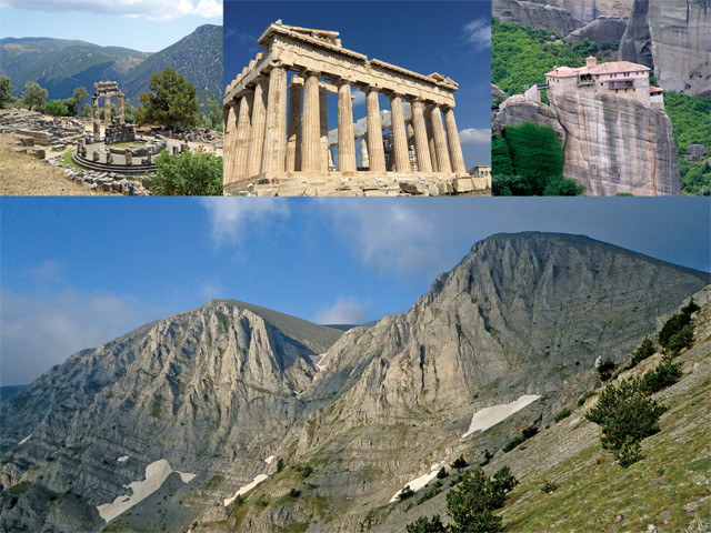
Although many visitors head to Greece to visit the islands and Athens, peninsular Greece has many incredible sights to see as well, including (clockwise from top left) the ruins of Delphi, home of antiquity's most famous oracle; the Acropolis; the unfathomable monasteries in Meteora; and Mount Olympus, the legendary home of the 12 Olympian gods and goddesses. Credit: all: Terri Cook and Lon Abbott.
The night before we were scheduled to fly to Athens last summer, the Greek government indefinitely closed the country’s banks and imposed strict capital controls, including limitations on ATM withdrawals and credit card use, to prevent the collapse of their banking system. The evening news led with images of panicked tourists hoping they could withdraw enough money to pay for their hotel before the cash ran out.
With Greece’s economy on the brink, we were unsure of what to do. While we did not have reason to be concerned for our safety, we did not want to be stuck in long ATM lines and disruptive protests once we arrived. But our airline tickets were nonrefundable, and skipping Greece would be a huge disappointment to our 11-year-old daughter, so after withdrawing as much cash as we could, we apprehensively boarded our flight.
In the end, there was no need for worry as the trip went perfectly and there was no massive collapse — at least not an economic one. There has been a different type of collapse occurring in central and northern Greece for millions of years, however: a tectonic collapse. This process is ultimately responsible for creating some of the nation’s most stunning scenery, the very attractions that we were hoarding our Euros to see.
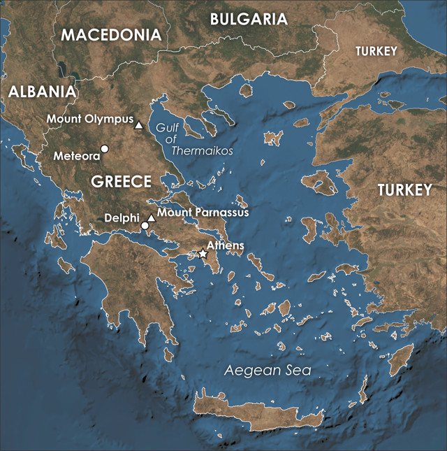
The easiest way to access the sites of peninsular Greece is via rental car. Credit: K. Cantner, AGI.
Although it sounds at least as dramatic as an economic meltdown, tectonic collapse isn’t necessarily a bad thing. Caused by gravity, it’s a geologic process that occurs due to the stretching and thinning of Earth’s crust. Extension in the Aegean beginning roughly 24 million years ago is primarily responsible for creating the series of parallel, northwest-southeast-trending mountain ranges and valleys that characterize peninsular Greece.
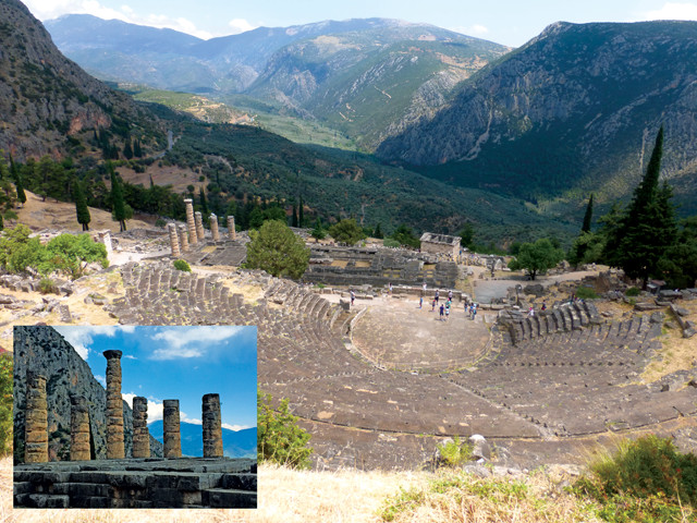
Often described as the spine of Greece, the central Pindus Range includes Mount Parnassus, a stunning mountain where antiquity’s most famous oracle — the oracle of Delphi — once prophesized, and where lonely columns still guard the ancient Sanctuary of Apollo. Farther north at Meteora, across the valley from the Pindus Range, a series of stone monasteries, some dating as far back as the 14th century, sit precariously atop pillars of conglomerate up to 450 meters high.
Northeast of Meteora, along the western edge of the Gulf of Thermaikos, another parallel range hosts the lofty 2,917-meter-high summit of Mount Olympus, Greece’s highest point and the mythical home of the Olympian gods and goddesses. After visiting Athens, Delphi and Meteora, our family planned to climb this peak together, staying overnight at one of the cozy huts on the mountain’s storied slopes — assuming we still had enough Euros to get there.
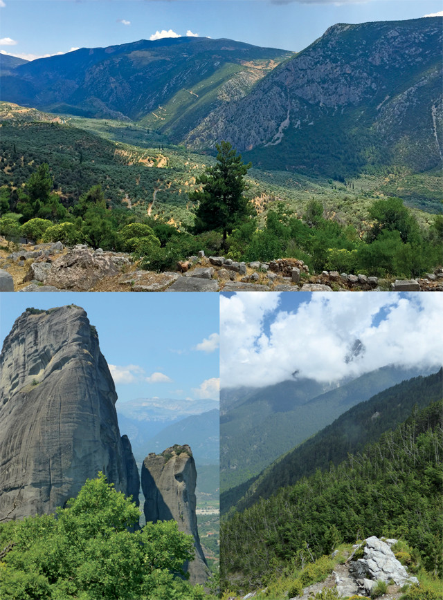
Tectonic collapse due to crustal extension starting 24 million years ago is responsible for the stunning topography of peninsular Greece, as seen here: looking down the valley from the Temple of Apollo, from where the oracle at Delphi once prophesized, in the Pindus Range; the 450-meter-high conglomerate pillars at Meteora, across the valley from the Pindus Range; and the lofty heights of Mount Olympus. Credit: all: Terri Cook and Lon Abbott.
About 200 million years ago, during the breakup of the supercontinent Pangea, what is now Africa was separated from Eurasia by a large embayment in the global ocean known as the Tethys Sea. The Tethys covered the area now occupied by modern Greece, and the edge of Eurasia, paralleled by a subduction zone, lay to the northeast. While other parts of Pangea were separating, Africa slowly moved northeastward on a collision course with Eurasia, and the Tethys shrank as its dense floor subducted beneath the Eurasian continent.
Meanwhile, the opening of a series of small seas created fragments of continental material ripped off mainland Africa, which all became microcontinents. Most of the crust in these microcontinents was covered by shallow tropical seas, where marine limestones accumulated, but a few high spots also protruded as tropical islands.
During a protracted mountain-building episode that lasted from about 160 million to 25 million years ago, one limestone-covered microcontinent after another collided with the edge of Eurasia, creating the land of peninsular Greece. Each newly arrived sliver of crust was folded and tucked beneath the preceding one along a series of thrust faults. The result is a feature called a fold-and-thrust belt in which the highest (and earliest-arriving) microcontinent was wedged against the old Eurasian continental margin in northeastern Greece, and each subsequent portion of rock lay progressively lower and farther to the southwest.
As this accretionary process progressed, the compression uplifted one high coastal mountain range after another. Erosion from these ranges produced large volumes of debris that built up a series of steep sediment fans where the mountains reached the sea. These sediment fans, or fan deltas, consisted mainly of gravel. And as more and more sediment washed down from the mountains to the deltas, these gravels were buried and cemented into sturdy conglomerate, the rock that today forms Meteora’s striking pillars.
With the accretion of each new microcontinent onto Eurasia, the subduction zone — and Greece’s coastline — shifted southwest. Today, the subduction zone lies just offshore of western Greece, where it still produces earthquakes. As active compression migrated toward the southwest, gravity took over about 24 million years ago in northeast Greece. The mountains there, once held up by the compression, began to collapse under their own weight along a series of normal faults, creating the parallel series of basins (grabens) and ranges (horsts) that characterize peninsular Greece’s scenery today.
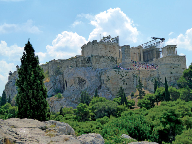
In contrast to the rest of Athens, which is built upon 70-million-year-old lightly metamorphosed bedrock called the Athens Schist, the hill of the Acropolis is a seemingly incongruous piece of 100-million-year-old limestone. Credit: Terri Cook and Lon Abbott.
Our daughter is fascinated by Greek mythology, so our Mediterranean itinerary had to include visits to the Acropolis in Athens and the ruins of ancient Delphi, both World Heritage sites. The stunning Acropolis is one of the most important archaeological sites in the world. At night, when the Parthenon’s glistening white Doric columns are lit by floodlights, the hilltop is an unforgettable sight, especially when viewed from Plaka, the cobblestoned neighborhood overflowing with traditional taverns, cozy coffee shops and boutique stores nestled at the base of the Acropolis’ steep slopes.
Begun by Pericles in 447 B.C., when the city-state of Athens was at the peak of its power, the Acropolis exemplifies classical Greece, and it also encapsulates the geologic history of peninsular Greece. In contrast to the rest of the city, which is built upon 70-million-year-old lightly metamorphosed bedrock called the Athens Schist, the hill of the Acropolis is a seemingly incongruous piece of 100-million-year-old limestone. This limestone, which originated as part of a package of rock higher in the Greek fold-and-thrust belt, was shoved up and over the younger schist during subduction. Subsequent erosion left behind a feature called a klippe, an isolated remnant of older rock sitting atop a thrust fault; the thrust fault in this case cuts across the base of the Acropolis’ steep limestone cliffs. Both the limestone and this thrust fault have been slightly offset in places by movement along small normal faults during Greece’s subsequent tectonic collapse. With both the subduction zone and many smaller normal faults still active, modern Greece remains seismically alive.
About 180 kilometers northwest of Athens, the ruins of the ancient city of Delphi stand at 580 meters elevation on the southwest flanks of Mount Parnassus. According to Greek mythology, after Zeus released two eagles from opposite ends of the world, they met at this spot, so ancient Greeks considered Delphi to be the center, or navel, of the world. After becoming an autonomous state, Delphi reached its zenith between the sixth and fourth centuries B.C., when the oracle’s prophesies influenced major religious and political decisions.
A thrust fault runs right through the Temple of Apollo, where the oracle would make her pronouncements. Research suggests the oracle may have received her visions thanks to carbon dioxide and methane or ethylene emanating from the fault zone. Credit: both: Terri Cook and Lon Abbott.
The ancient city is located in a spectacular setting on one of the horst blocks uplifted during Greece’s tectonic collapse. As you wander up the Sacred Way, which leads to the Temple of Apollo, the sanctuary’s most important monument, you can gaze down on the glistening Gulf of Corinth, which is a graben flooded by seawater. Like the Acropolis, the mountain that looms above Delphi is a klippe composed of limestone. But in this location, the limestone has been so intensely folded that the rock stack has been flipped over: The older limestone layers form the mountaintop, while the youngest layers are exposed at Delphi.
The limestone of Mount Parnassus overlies red shale, and the two rock stacks are separated by a thrust fault that runs right through the Temple of Apollo, where the oracle would make her pronouncements. The ancient Greeks wrote that the oracle would enter a trance after she chewed laurel leaves and breathed vapors from a chasm beneath the temple. No such chasm is evident today, but it has been suggested that carbon dioxide and methane or ethylene emanating from the fault zone induced her trances. The Castalian Spring, an important feature in the religious worship that occurred in ancient Delphi, is also located on the thrust fault, where the permeable limestone of the klippe meets the less permeable red shale, which forces groundwater to the surface.
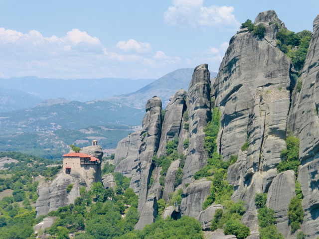
Meteora's monasteries perch atop spires of conglomerate deposited in a fan delta during the Oligocene and Miocene. Weathering and erosion gnawed away at the rock, especially along vertical joints, gradually separating the once-continuous sheet of sediment into today's spires. Credit: Terri Cook and Lon Abbott.
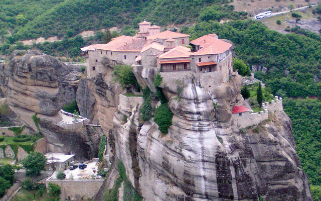
Starting in about the 14th century, monks began to build monasteries atop Meteora's spires. The area once hosted 24 such monasteries; six remain today. Credit: Terri Cook and Lon Abbott.
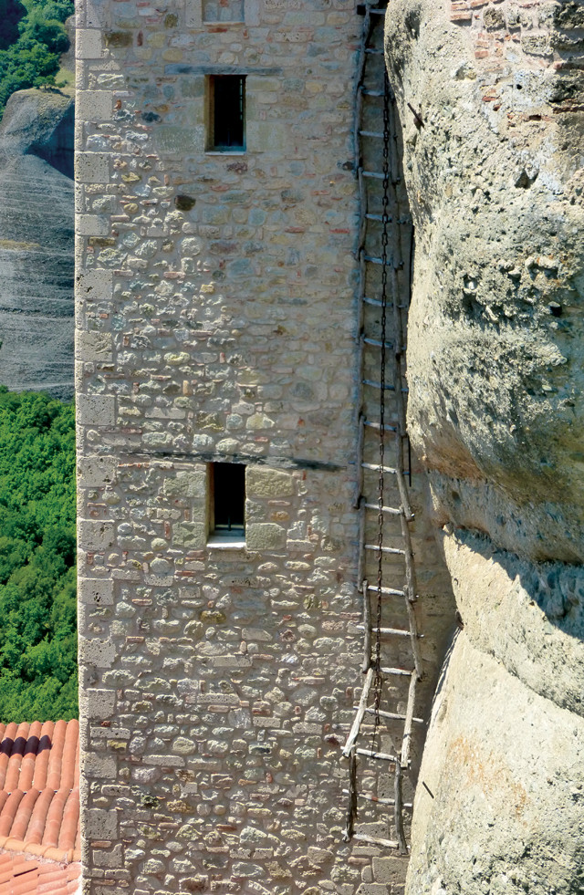
For centuries, the monasteries could only be reached by climbing removable ladders. Windlasses were later added so that brave monks could be hauled up in nets. Today, visitors can hike up steps carved into the rock. Credit: Terri Cook and Lon Abbott.
One of Greece’s most popular attractions, Meteora, whose name means “suspended in mid-air,” is a World Heritage-listed complex of monasteries built atop towering and (until modern times) nearly inaccessible “heavenly columns.” Beginning in the 11th century, Orthodox Christian monks began to settle the area, living in isolated caves carved into the conglomerate cliffs. By the 14th century, monks started working together to build safe and secluded retreats, using ladders, ropes and baskets — as well as gritty determination — to carry the construction materials to the top of the columns.
The conglomerate, whose pebbles comprise rock eroded from one of Greece’s pre-collapse mountain ranges, was deposited in a fan delta during the Oligocene and Miocene epochs. Tectonic collapse exposed this coarse rock on the east flank of the graben now occupied by the Peneios River. Once the conglomerate was exposed to the elements, weathering and erosion gnawed away at it, especially along vertical joints that are particularly susceptible to these processes. Erosion gradually separated the once-continuous sheet of sediment into today’s monastery-crowned spires, which for centuries could only be reached by climbing removable ladders. Windlasses were later added so that brave monks could be hauled up in nets.
Although the area once hosted 24 monasteries, only six remain today. These are accessible via steps carved into the rock of each column; the steps ascend from a paved road that meanders through the entire Meteora complex. With your own vehicle, you can visit all six in a day. Alternatively, you can take a bus up to the top and walk back down.
Regardless of which way you choose to explore, be sure to save enough time to visit Moni Megalou Meteorou, the largest, oldest and highest monastery in the complex. Founded around 1340 by Saint Athanasios, Moni Megalou became the most powerful monastery after a Serbian emperor abandoned his wealth and power to become a monk. Like the other monasteries, Moni Megalou is built around a central courtyard. In its center rises the katholikon, the central worship space, which features a 12-sided dome decorated with a famous series of colorful frescoes dating to the very end of the 15th century. Also worth visiting is Moni Agias Varvaras Rousanou, which is accessed by a narrow, wooden bridge. Its dome features amazing frescoes, including one of the Resurrection, painted by a famous Cretan artist in 1527.
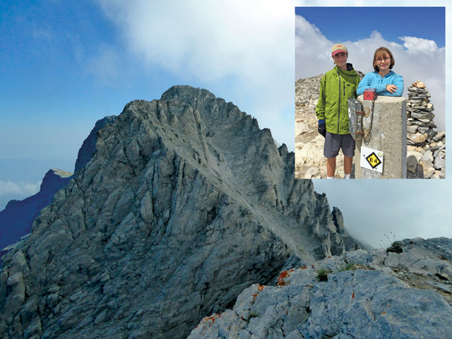
Hikers on Mount Olympus can choose whether to climb Mytikas (below), the true summit, which requires scrambling over exposed terrain, or Skolio (right), the lower but much more straightforward peak to the southwest. Skolio is a safer, easier route for families. Credit: both: Terri Cook and Lon Abbott.
Throughout the hike up Mount Olympus, visitors are surrounded by Mesozoic limestone. Credit: Terri Cook and Lon Abbott.
We are a hiking family, so after carefully doling out our Euros, our final stop was Mount Olympus, Greece’s highest mountain and the home of the 12 Olympian gods and goddesses. Mount Olympus, in Olympus National Park, is the northernmost in a chain of three peaks located on another northwest-southeast-trending horst. The other two peaks also figure prominently in Greek mythology. Mount Ossa is home to the Nymphs, and Mount Pelion is the home of the half-man, half-horse Centaurs.
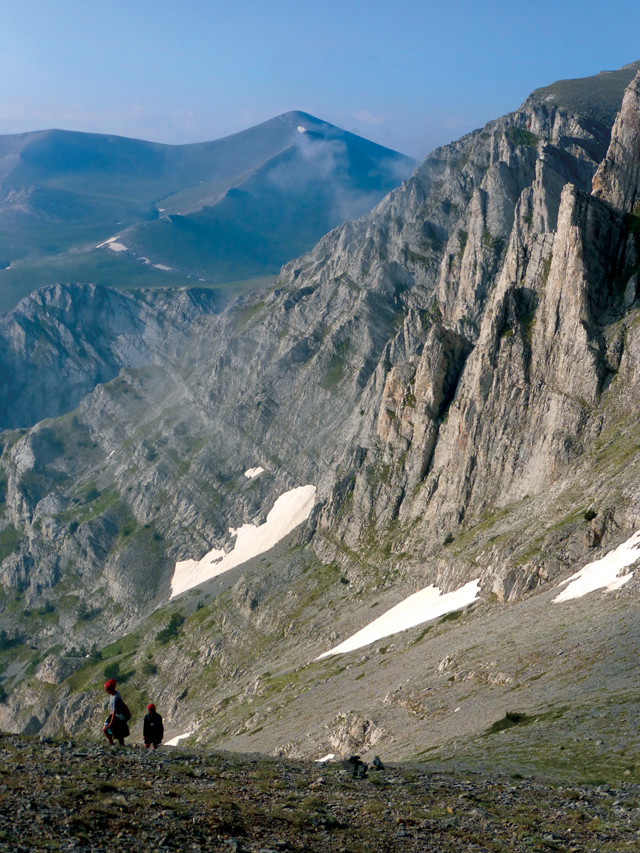
The staging spot for the two-day ascent of Olympus is the quaint village of Litochoro, where a winding road leads to an end-of-the-world café at Prionia. From there, the steep but well-maintained E4 trail leads through gorgeous scenery for 6 kilometers up to a well-appointed hut, which serves up heaping plates of pasta, bowls of hearty soup and steaming mugs of cocoa to visitors from all over the world. Most hikers spend one night at the hut, then leave early the next morning to climb the additional 3 kilometers that zigzag to the Skala saddle.
Throughout the hike, we were surrounded by Mesozoic limestone reminiscent of that at Delphi. Although the Olympus limestone also appears to be a klippe, it’s actually the opposite: It’s a tectonic “window,” where erosion has carved out exposures of rocks from lower in the fold-and-thrust stack.
From the Skala saddle, hikers must decide if they want to climb Mytikas, the true summit, which requires some scrambling over exposed terrain, or Skolio, the slightly lower but much more straightforward peak to the southwest. With the kids along, we chose to scale Skolio. With amazing views down to the waters of the Thermaikos Gulf, which fills another graben, there is no better place to appreciate the scale of Greece’s tectonic collapse. While we rested atop the peak and enjoyed these views, a single clap of thunder echoed across the landscape, which we interpreted as none other than Zeus, approving of our decision to proceed with our trip.
© 2008-2021. All rights reserved. Any copying, redistribution or retransmission of any of the contents of this service without the expressed written permission of the American Geosciences Institute is expressly prohibited. Click here for all copyright requests.