
by Terri Cook and Lon Abbott Tuesday, June 5, 2018
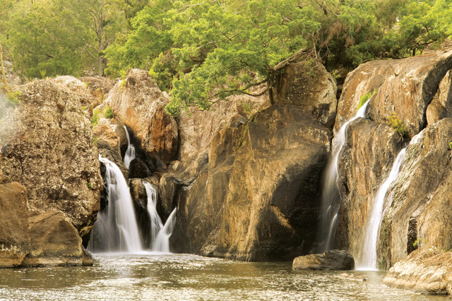
Little Millstream Falls near Ravenshoe, Atherton Tablelands, North Queensland, Australia. Credit: ©Shutterstock.com/Ralph Loesche
Just one breathtaking hour’s drive from Cairns, the gateway to the Great Barrier Reef on the coast of Queensland, in northeastern Australia, the scenic Atherton Tablelands, with their young volcanoes, dramatic waterfalls and lush rainforest, rise a thousand meters above the humid coastal plain. On a leisurely day trip you can circumnavigate this nearly flat plateau, soaking up the scenery formed by some of the continent’s youngest volcanoes, ambling through threatened rainforest ecosystems, and sampling exotic tropical produce.
The Great Dividing Range
Start your excursion from Cairns by driving south across the narrow coastal strip to Gordonvale, where you turn onto the Gillies Highway for a serpentine ascent up the impressive escarpment. Pause at Heales Lookout, elevation 600 meters, for a beautiful vista down to the Coral Sea. The escarpment marks the edge of the Great Dividing Range, a series of plateaus that runs the length of Australia’s east coast and forms its highest topography. Underlying the Tablelands and the rest of the Great Dividing Range is a series of contorted sedimentary and metamorphic rocks — obscured here by the thick rainforest — belonging to the Tasman Fold Belt. Through the late Paleozoic and early Mesozoic, this belt was the scene of active subduction as an ancient supercontinent, Gondwanaland, swept up a series of volcanic island chains like a windshield smashing bugs. This violent tectonic activity appended the real estate comprising eastern Australia to the supercontinent, contorting these rocks in the process.
Young volcanic rocks cap the ancient basement rocks, providing quite an age contrast. Just a few kilometers beyond the lookout, the road tops out on the Tablelands’ relatively flat volcanic surface. Here Crater Lakes National Park protects two unusual volcanic craters, called maars, that host lakes Eacham and Barrine. Tucked away in remnants of the Mabi rainforest, these maars formed when hot basaltic magma encountered groundwater, causing an explosive steam eruption. Short walking tracks circle both lakes, allowing visitors to soak in the beauty of the craters and their cloaking rainforest. Maars are rare in Australia; these owe their existence to the area’s unusual combination of young volcanics, abundant rainfall, and associated high groundwater table.
The maars are just two of 52 eruptive centers, collectively known as the Atherton volcanic province, whose dark lava flows cap 1,800 square kilometers of Tablelands. In turn, this province is just one of many volcanic centers scattered along the entire 4,400-kilometer-long Great Dividing Range that together have erupted 20,000 cubic kilometers of basalt over the last 70 million years. The volcanism has left a particularly obvious mark here, largely because the Atherton volcanoes are some of the continent’s youngest, ranging from 3.1 million to a mere 20,000 years old.
Glimpses of the Mantle
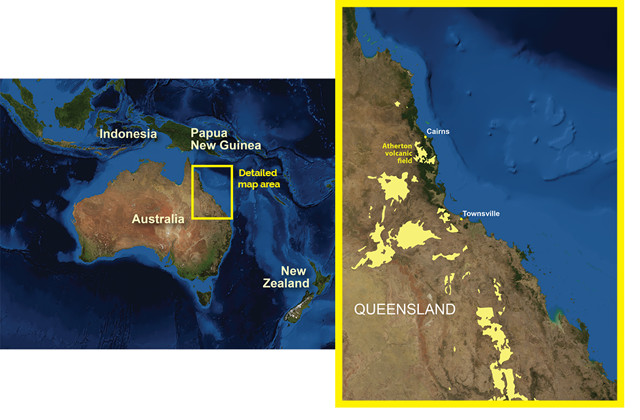
The lava fields and volcanoes of northeastern Australia, including the Atherton volcanic field (in yellow on the map) and offshore seamounts, parallel the Great Dividing Range. Credit: AGI/NASA
Geologists have long debated how and when the Atherton Tablelands — and the rest of the Great Dividing Range — formed. One hypothesis is that the range is the remnant of a larger highland uplifted during the series of collisions that created the Tasman Fold Belt. But the fact that so much volcanism has occurred along the Great Dividing Range suggests to other geologists that the range instead owes its existence to volcanic activity. In this model, rifting events that opened the Tasman and Coral seas east of Australia 84 million to 53 million years ago caused the underlying mantle to partially melt, creating magma. Some of that magma leaked to the surface during and after the rifting event, forming the Atherton and other volcanic provinces. However, most of the magma cooled 40 to 50 kilometers beneath the surface, underplating and thickening the continental crust beneath the range. Because continental crust is more buoyant than the underlying mantle rock, this magmatically induced crustal thickening beneath the Great Dividing Range triggered the range’s rise in elevation.
Our knowledge of the material composition beneath the Tablelands has been greatly enhanced thanks to small chunks of mantle and lower crust that were carried to Earth’s surface during the eruptions of the Lake Eacham and a handful of other Atherton volcanoes. Known as xenoliths (“foreign rocks”), these samples of Earth’s interior have allowed geologists to probe the thickness and composition of the crust and the temperature of the underlying mantle. Their results are consistent with inferences gained from seismic studies and collectively support a model of mantle heating and melting. Many Atherton and other east Australian volcanoes also carried to the surface xenocrysts (“foreign crystals”), providing great “fossicking” — a local term meaning amateur prospecting for minerals, gems or fossils — for unusual gems like sapphires, rubies, peridot, garnet and even diamonds.
Ancient Trees in Yungaburra
Just two kilometers down the road from Lake Eacham, the quaint town of Yungaburra hosts 18 historic buildings and offers a great selection of cafés, restaurants and day spas. Yungaburra is surrounded by agricultural fields and several basaltic cinder cones, including the Seven Sisters and Mount Quincan, the latter of which hosts an especially rich suite of xenoliths. Thanks to the region’s tropical rains, the lava and cinders spewed out by these and other volcanoes have rapidly weathered to the rich, red soil you see here. This soil is ideal for crops, making the Tablelands one of Queensland’s most productive agricultural regions.
The ecological impact of these rich volcanic soils is on spectacular display within walking distance of Yungaburra at Curtain Fig National Park. The park protects another small remnant of the Mabi rainforest, which only grows on exceptionally fertile soils where rainfall is a soggy 1,300 to 1,600 millimeters per year. The Mabi rainforest once blanketed the Atherton Tablelands, but due to clearing for agriculture, only 2 percent remains. This small patch would likely have been cleared as well were it not for the numerous basalt boulders scattered throughout the area by a recent eruption that make this site unattractive for agriculture.
The park is named for a giant fig tree that extends a spectacular drapery of aerial roots 15 meters down to the forest floor. The Curtain Fig is one of the most frequently visited sites in the Wet Tropics World Heritage Area, designated in 1988 for providing an unparalleled living record of the evolutionary processes that shaped Australia’s flora and fauna over hundreds of millions of years — since the time it was part of Gondwanaland. The Wet Tropics rainforest possesses more taxa with ancient (primitive) characteristics than anywhere else on Earth. It represents the living ecosystem most similar to the Oligocene-Miocene rainforests that were home to the world-renowned Riversleigh fossil marsupials. Riversleigh, located in interior Queensland, was designated as a World Heritage Site in 1994 because of its remarkable fossil record of marsupial evolution.
Basalt Waterfalls and Platypus Sightings
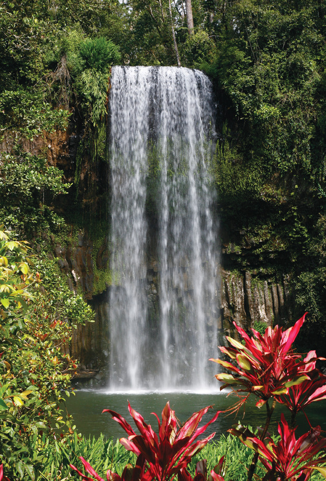
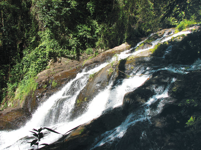
Millaa Millaa Falls pours over a ledge of columnar basalt that flowed down the ancestral Johnstone River channel. Credit: iStockphoto.com/John Kirk
From the Curtain Fig, proceed south to the town of Malanda, the heart of the world’s only tropical dairy industry. The Malanda Dairy Centre provides guided tours of milk production and cheese making, and its café features delicious local dairy products and produce. Malanda Falls, where the North Johnstone River spills over a ledge of basalt, is another town attraction.
Two million years ago, the Johnstone River flowed southeast down a channel a few kilometers south of here. Then a volcanic eruption sent a torrent of lava down the riverbed, where it tumbled over the escarpment to the coastal plain below. This is one of only three places where lava flows have spilled over the escarpment, allowing geologists to constrain when the escarpment formed. Once the lava cooled, the Johnstone River channel was plugged with a tongue of hard basalt that the river could not easily breach. The erosion shifted the flow to where the river encountered much softer sedimentary rocks, causing the river to split into two forks.
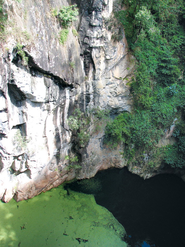
Hypipamee Crater is a diatreme blasted through sheer walls of granite. Credit: Lon Abbott & Terri Cook
From Malanda, head farther south to Millaa Millaa, where you have another opportunity to sample local organic cheese and yogurt at the Mungalli Creek Dairy and stroll through the rainforest on the Mamu Rainforest Canopy Walkway, built through the path of destruction wrought by Cyclone Larry in March 2006. Millaa Millaa is the place to begin the 16-kilometer-long “waterfall circuit,” a tour of four beautiful Atherton waterfalls. If you only have time to visit one, make it Millaa Millaa Falls, one of the most photographed in Australia. There, Theresa Creek plunges 18 meters down a cliff of columnar basalt formed by the flow that blocked the Johnstone River. It has a popular swimming hole where you may spot a platypus, one of only two egg-laying mammals on Earth. These odd-looking creatures are of significant scientific interest because they constitute an important evolutionary link between mammals and reptiles. Platypuses only live in northeastern Australia, and more of them live in the Tablelands than anywhere else.
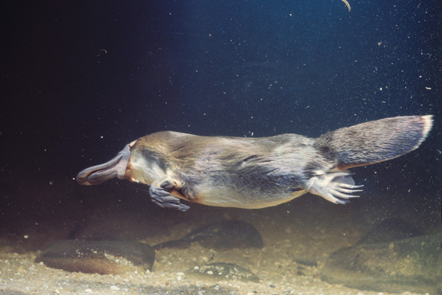
Platypuses are monotremes, egg-laying mammals that are unique to Australia, and one of few venomous mammal species. Credit: ©iStockphoto.com/John Carnemolla
The next geoattraction on the way to Atherton is Hypipamee National Park, which hosts the Atherton volcanic field’s only diatreme, an impressive crater 60 meters in diameter and 140 meters deep, that was blasted out in a violent eruption of gaseous magma that rose from the mantle as rapidly as 10 meters per second. The crater wall consists of Paleozoic granite, the rock that underlies this portion of the volcanic field. Search around the rim for basalt “bombs,” dark oblong rocks ejected from the volcano that contain blocks of granite ripped from the walls as the magma burst upward toward the surface.
Completing the Atherton Circuit
As you drive inland toward Heberton, the climate becomes noticeably drier, with eucalyptus trees supplanting the rainforest. Heberton is the oldest town on the Tablelands, founded when tin was discovered here in 1880. One hundred years of mining yielded 150,000 tons of ore, making this town Australia’s biggest tin producer. Several historic buildings remain, including the Heberton Mining Museum, erected on the historic Great Northern Mine site. The Atherton volcanic field plays a role in Heberton’s history as well. The tin was emplaced during the intrusion of the Paleozoic granites like those at Hypipamee Crater. Millions of years of subsequent erosion concentrated the tin in river gravels, which are interlayered with Atherton basalt flows. Miners tunneled beneath the uppermost basalts to reach the tin-bearing gravels.
The Atherton Tablelands, a short drive from Cairns, is famous for its many beautiful waterfalls. Credit: Lon Abbott & Terri Cook
From Heberton it’s a short drive to Atherton, the Tablelands’ economic center. Agriculture drives the town, with tropical specialties like macadamia nuts, coffee, bananas, sugarcane, avocados and citrus dominating the produce. To complete the circuit, head north along the Kennedy Highway to Mareeba, where you can sample local coffee or mango wine on one of the many “food trail” tours. Here you can also view freshwater crocodiles, kangaroos and tropical birds on the 2,000-hectare Mareeba Wetlands preserve, or feed endangered Mareeba Rock Wallaby and see towering termite mounds at Granite Gorge.
From Mareeba it is a quick trip down the Kennedy Highway to Cairns, a scant 68 kilometers away. You’ll be back in bed early enough to rest up for another amazing day of snorkeling on the Great Barrier Reef.
© 2008-2021. All rights reserved. Any copying, redistribution or retransmission of any of the contents of this service without the expressed written permission of the American Geosciences Institute is expressly prohibited. Click here for all copyright requests.