
by Mary Caperton Morton Tuesday, June 12, 2018
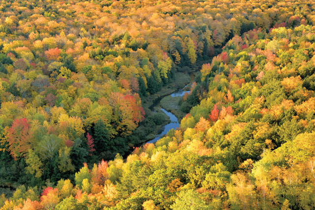
Michigan's Upper Peninsula is a great place to view the colors of fall. Credit: ©iStockphoto.com/Bill Grove
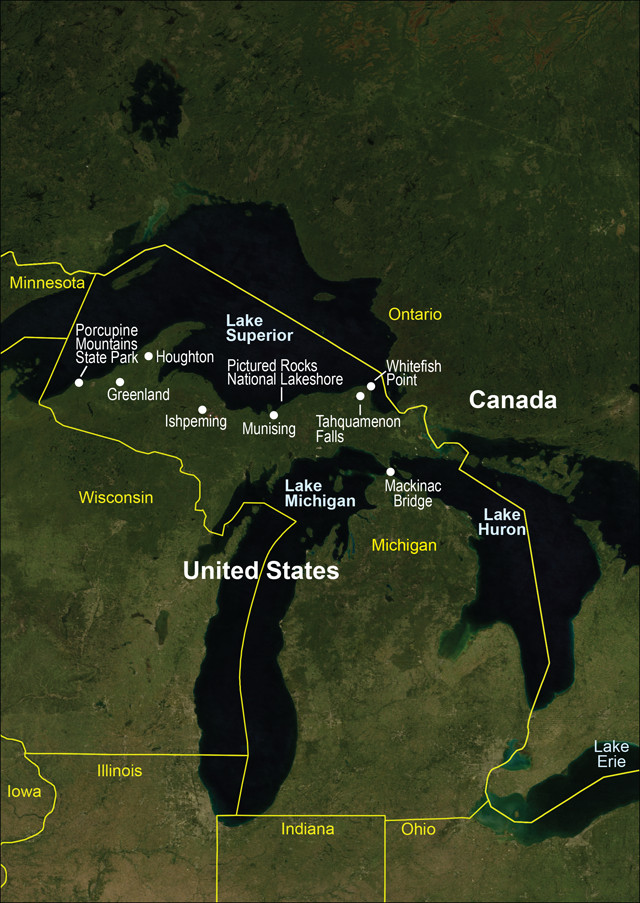
Credit: AGI/NASA
You have to be tough to be a Yooper. Between the epic lake-effect snow, ship-sinking storms and summertime swarms of black flies, Michigan’s remote and rugged Upper Peninsula is one of the last true wild outposts in the lower 48 states. But while living in the U.P. may not be for everybody, a visit in any season will delight rock hounds, beachcombers, wildlife watchers, storm seekers and fall colors enthusiasts.
The U.P. is surrounded on three sides by the waters of lakes Michigan, Huron and Superior. These are the largest of the five Great Lakes, which together hold more than one-fifth of the world’s surface freshwater, enough to drown the lower 48 states under 3 meters of water.
The foundation for the Great Lakes was laid 1.2 billion years ago, when faulting of the Midcontinental Rift created a basin in what is now known as the Great Lakes Tectonic Zone. Eons later, during the glacial periods of the Pleistocene, glaciers deepened parts of the basin, and when the Laurentide Ice Sheet finally retreated about 10,000 years ago, meltwater filled the deepest lobes, creating the Great Lakes.
Today, Michigan’s Upper Peninsula stretches from Ontario, Canada, in the east to Wisconsin’s northern border in the west and is divided into two major biomes: the flat, swampy Great Lakes Plains in the east and the steeper, more craggy Superior Upland in the west. This swath contains nearly one-third of Michigan’s landmass, but less than 3 percent of the state’s total population. Locals call themselves “Yoopers,” and from time to time, vote enthusiastically for the peninsula to secede from Michigan and become “Superior,” the 51st state.
The Yoopers’ lack of connection to the rest of Michigan isn’t just political: The Upper and Lower peninsulas are separated by a strip of water known as the Straits of Mackinac, which connects lakes Michigan and Huron. Because of this strip of water, Michigan and Huron are not hydrologically separate lakes, but rather a massive two-lobed lake called Lake Michigan-Huron.
To visit the U.P., start at the Big Mack. In 1957, the Mackinac Bridge was built across the Straits of Mackinac, despite fierce Yooper opposition, and to this day the four-lane span is the only way to access the U.P. by car from the rest of Michigan. (From Wisconsin, you just drive across the border.) Big Mack is a fitting nickname for the bridge: At nearly 8 kilometers in length, it’s one of the longest suspension bridges in the world. Crossing Big Mack can be harrowing. Strong crosswinds routinely close the bridge in winter, and even in good weather, the long crossing can be downright vertiginous. If you suffer from gephyrophobia — a fear of bridges — don’t fret: The Mackinac Bridge Authority offers a Drivers Assistance Program that provides drivers to pilot cars across the bridge, free of charge.
Now that you’ve seen lakes Michigan and Huron (or Lake Michigan-Huron if you’re the technical type), head north up Highway 123 to visit Lake Superior. As you cross the eastern part of the U.P., keep in mind that this landscape is much different from the western half of the peninsula. The eastern half is younger, composed mainly of marine sedimentary rocks deposited during the Cambrian through Silurian periods, between 540 million and 415 million years ago, overlain by younger glacially derived material left behind by the final retreat of the Wisconsinan glaciation 10,000 years ago.
Much of the eastern half of the U.P. is relatively flat and heavily forested. Several major rivers connect large inland lakes with the Great Lakes, and the region is known for its large, colorful waterfalls. The rivers are notably brown and gold in color due to the tannins leached from the dominant cedar and hemlock forests. One of the largest and most colorful of these waterfalls is Tahquamenon Falls — sounds like phenomenon — housed within Tahquamenon Falls State Park just west of Paradise.
In early spring, the Tahquamenon River drains as much as 50,000 gallons of water per second, making the Tahquamenon’s Upper Falls the second-most voluminous falls east of the Mississippi, after Niagara. Both the Upper and Lower falls are easily accessible from the park’s two parking lots. A 6.5-kilometer-long trail along the Tahquamenon River also connects the Upper and Lower falls. On weekends during the spring and summer, a free park shuttle runs back and forth between the falls, enabling a nice one-way, point-to-point hike. Afterward, grab a pint and bite to eat at the Tahquamenon Falls Brewery and Pub, located at the Upper Falls parking lot.
After a good meal, Lake Superior awaits at Whitefish Point, about 17 kilometers north of Paradise. Whitefish Point, home to the Whitefish Point Bird Observatory, the Whitefish Point Lighthouse and the Great Lakes Shipwreck Museum, is known as one of the best spots if you’re a birdwatcher and one of the worst places to be if you’re on a ship in a storm.
Hundreds of Great Lakes freighters have sunk in the waters off Whitefish Point, including the Gordon Lightfoot-ballad-inspiring Edmund Fitzgerald, which lies just 24 kilometers northwest of the point. On Nov. 9, 1975, a storm whipped Lake Superior into a frenzy: 160-kilometer-per-hour winds produced 10-meter-tall waves, and the combination proved to be too much for the 222-meter-long Fitzgerald. Without sending a single distress signal, the freighter sank to the bottom of Lake Superior, killing all 29 men aboard.
Artifacts from the Fitz and dozens of other wrecks are housed at the Shipwreck Museum, open daily from 10 a.m. to 6 p.m., May through October. The museum closes in time for a private ceremony on the anniversary of the Fitzgerald’s sinking. Every Nov. 9, often in the midst of a swirling tempest, family members of the 29 sailors gather at Whitefish Point to remember their lost loved ones.
November is historically the deadliest month on the Great Lakes. On average, the greatest temperature differential between the still-warm lakes and rapidly cooling air above occurs around Nov. 10. This differential creates strong winds above the lakes, which intensify even minor storms. In winter, major weather patterns often converge over the Great Lakes and the resulting storms are legendary.
Much of the rest of Shipwreck Coast, which stretches from Whitefish Point west to Munising, is protected by Pictured Rocks National Lakeshore, a remote park that is all but inaccessible from land. The best way to see the park’s painted sandstone cliffs and massive sand dunes is by boat. Pictured Rocks Cruises, run out of Munising, offers 3-hour cruises along the lakeshore, coming within an arm’s length of 60-meter-high cliffs. Minerals leaching out of the 500-million-year-old red sandstone streak the cliffs red (iron), black (manganese), yellow (limonite), and green and blue (copper).
Driving west from Munising, the U.P. becomes increasingly more rugged. This region sits atop the southernmost portion of the Canadian Shield, a massive formation of ancient basalt that underlies much of central Canada. Home to some of Earth’s oldest rocks, the Canadian Shield dates back to the Archean and Proterozoic eons, between 2.7 billion and 2.5 billion years ago. The U.P.’s Superior Upland, however, is a bit younger, between 1.8 billion and 1.2 billion years old.
Over the past couple of billion years, metals leached out of groundwater and settled in pockets in the topmost porous layer of basalt. As a result, the western U.P. is rich in iron ore and copper. Michigan’s Marquette Iron Range formation, discovered in 1844 beneath Marquette County, still produces one-quarter of all the iron ore mined in the United States. The town of Ishpeming, an hour west of Munising in the foothills of the Superior Upland, is home to the Michigan Iron Industry Museum and the National Ski and Snowboard Hall of Fame.
This region of the U.P. is also known as Copper Country for its once-numerous copper mines. During the late 1800s through the 1920s, the western U.P. supplied as much as 90 percent of the country’s copper. The U.P.’s copper deposits are extremely unusual because they occur in pure metallic form as large chunks of native copper. Elsewhere in the world, copper combines with other minerals and must be chemically processed to produce metallic copper. A number of U.P. copper mines also contain silver, both in native form and naturally combined with copper in a unique alloy known as halfbreed that is only found in the U.P.
The U.P.’s last copper mine shut down in 1995, and several mines are now open to the public. The Adventure Mining Company in Greenland offers easy hour-long walks through the mines as well as 3-hour expeditions deep underground. Nearby, the Caledonia Mine caters to mineral collectors looking for native copper, silver, datolite, quartz, feldspar, calcite and epidote.
The Upper Peninsula’s crown jewel lies on the peninsula’s far western border, along the coast of Lake Superior. The Porcupine Mountains Wilderness State Park towers above the rest of the U.P. Known as the “Porkies,” the mountains are home to porcupines, as well as black bears, timber wolves, river otters, lynx and moose. The native Ojibwe people gave the Porkies its name because the silhouette of the park’s mountains resembles a hunchbacked porcupine.
The most striking geological feature of the Porcupine Mountains is the long basalt and conglomerate escarpment running parallel to the Lake Superior shore, separating the picturesque Lake of the Clouds from Superior. The Lake of the Clouds overlook, a short stroll from the parking lot, might qualify as one of the most scenic vistas for viewing fall foliage because the Porcupine Mountains are home to one of the most extensive stands of old growth northern hardwood forest in North America; more than 13,000 hectares of virgin sugar maple, American basswood, eastern hemlock and yellow birch fill the lake valley below the 600-meter-tall escarpment.
The Porkies are a backpacker’s dream destination. Dozens of trails loop through the park, connecting the Superior lakeshore with river valley and escarpment hikes. Wilderness cabins are available for nightly rentals, and primitive campsites abound. Spring and summer are mild, though black flies and mosquitoes can be a plague from mid-May through mid-June. Bug spray, head nets, long sleeves and pants are a must.
Visiting the Porkies in winter may also seem daunting — parts of the western U.P. receive between 600 and 900 centimeters of snow a year due to the weather influence of the Great Lakes — but with the right equipment, the park can be a winter wonderland. Snowmobile trails are so well-established that trail intersections are marked with stop signs. Or if you prefer your winter solitude machine-free, many park trails are groomed for cross-country skiing and snowshoeing. The Porcupine Mountains Ski Area also offers downhill skiing. Winter lodging can be found in nearby Ontonagon, Silver City and White Pine. Park wilderness cabins are also a great alternative to snowy tent camping.
Visiting Michigan’s Upper Peninsula at any time of year requires advanced planning, equipment to deal with bugs, storms and snow, and the fortitude to travel in a place where towns are few and far between. But for hardy geology-minded travelers, the U.P. offers endless opportunities. You never know, after a visit you might just fall in love with the 51st state, buy a cabin, a few gallons of bug spray and a snowmobile, and become a full-fledged Yooper.
© 2008-2021. All rights reserved. Any copying, redistribution or retransmission of any of the contents of this service without the expressed written permission of the American Geosciences Institute is expressly prohibited. Click here for all copyright requests.