
by Terri Cook Monday, December 8, 2014
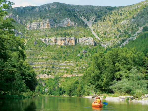
Canoeing offers impressive views of the limestone walls of the Tarn Gorge in Cévennes National Park in France. Credit: Terri Cook and Lon Abbott.
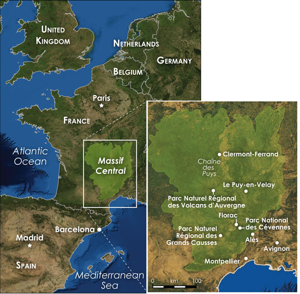
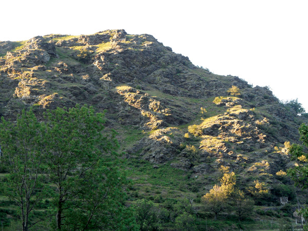
The Massif Central is a roughly 5,000-square-kilometer highland region in south-central France filled with volcanic necks, scenic gorges and picturesque parks and towns. Credit: Kathleen Cantner, AGI.
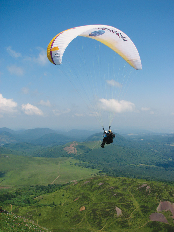
Paragliders soar after departing from the Puy de Dôme, the highest point in the northernmost of three chains of volcanoes in the Massif Central. Credit: Terri Cook and Lon Abbott.
Tucked between the Pyrenees and the Alps in south-central France is a little-known highland called the Massif Central. This rugged and secluded region is celebrated for its natural beauty, which is preserved in several large parks that attest to the area’s long and diverse human and geologic history. At the heart of the Massif Central is the picturesque town of Le Puy-en-Velay, known for its green lentils, handcrafted lace and potent Verveine liqueur. There, an arresting trio of volcanic necks capped with historical attractions looms above medieval houses, lace workshops and cobblestone streets where pilgrims have gathered for more than a thousand years to begin their long journey to one of Christendom’s holiest sites.
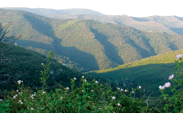
On the Massif’s southeastern edge, clusters of quaint, slate-roofed buildings and local markets bursting with fresh produce and creamy cheeses are dwarfed beneath a series of limestone-capped plateaus. These have been deeply dissected by narrow river canyons whose walls tell the tale of an ancient mountain range created during the assembly of a supercontinent. Along the Massif’s western reaches, three youthful chains of volcanoes dominate the landscape. The northernmost is the Chaîne des Puys, a 40-kilometer line of more than 75 volcanic hills, locally known as “puys.” The highest of these puys is home to one of the country’s best paragliding locales and is the site of a 2nd-century Roman temple honoring Mercury, patron of merchants, thieves and the intrepid travelers who visit this isolated land of lentils, lace and lava.
The Massif Central is a broad, elevated region whose origins date back to the assembly of Pangaea, Earth’s last supercontinent. The Massif is part of a twisting belt of mountain ranges that extends more than 3,000 kilometers across Western Europe from Portugal, Ireland and England, through France and Germany, to the Czech Republic. This belt formed during the Devonian and Carboniferous periods as the result of a massive continent-continent collision.
During this event, which geologists refer to as either the Hercynian or Variscan Orogeny, Africa slammed into a united North American-northern European landmass. The evidence for this can be found in the Massif Central’s basement rocks, a series of highly deformed metamorphic rocks — including slate, a locally important roofing material — with a planar, parallel alignment of clay crystals. This “foliation” is an important indicator that the rock was metamorphosed under conditions in which the tectonic pressure was concentrated in one direction, which occurs when two tectonic plates converge.
The Massif Central is a broad, elevated region, the origins of which date to the assembly of Earth's last supercontinent, Pangaea. Credit: Terri Cook and Lon Abbott.
The Massif Central’s foliated metamorphic rocks were also intruded by magma, creating nearly contemporaneous granite. The southern Massif Central thus has several granite peaks, including Mount Lozère, the highest point in Cévennes National Park at 1,699 meters elevation.
Following these tectonic fireworks, the region experienced a quiescent phase during which erosion slowly beveled the Hercynian metamorphics and granites down to a nearly flat surface. During the Jurassic Period, as Pangaea slowly broke apart, the sea covered much of the Massif, depositing a thick sequence of limestone layers atop the remnants of this once-mighty mountain range.
As Earth’s plates slowly reorganized, Africa moved north, eventually crashing into Europe in the Cenozoic in a messy series of collisions that raised mountain ranges across the continent, including the Pyrenees and later the western Alps. Between these ranges, the southern edge of the Eurasian Plate was also deformed, although to a much lesser extent. Rather than being severely crumpled, the Hercynian basement rocks and overlying limestones were gently uplifted, creating a broad, flat plateau covering nearly 5,000 square kilometers. As erosion again took over, rivers carved up this area, creating a striking landscape of individual limestone-covered plateaus that the French call “causses.”
Hercynian basement rocks in France's Massif Central. Credit: Terri Cook and Lon Abbott.
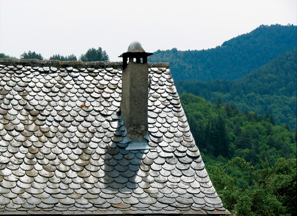
The buildings in the charming village of Florac, one of 250 villages in Cévennes National Park, are roofed with thick slate tiles. Credit: Terri Cook and Lon Abbott.
Several of the causses are protected in the Parc Naturel Régional des Grands Causses, which is adjacent to Cévennes National Park. Together these reserves comprise a UNESCO World Heritage Site that celebrates the region’s 3,000 years of agro-pastoral history, including the continuing tradition of transhumance — the seasonal migratd their livestock between winter grounds and summer pastures high on the slopes of Mount Lozère.
The southern Massif Central is a haven for hikers, equestrians, mountain bikers, rock climbers and (thanks to the Jurassic limestone cap) cavers. Cévennes National Park boasts three amazing caves, including Aven Armand, which is large enough to hold Paris’s Notre-Dame Cathedral. The park also hosts nearly 2,500 kilometers of marked trails, including the 250-kilometer-long GR70, the trail blazed in 12 days in 1878 by Scottish author Robert Louis Stevenson and his donkey, Modestine — a journey he wrote about in “Travels With a Donkey in the Cévennes.” Today, you can retrace Stevenson’s route with your own donkey and a backpack, or, if you prefer, a baggage-handling service. The Stevenson Trail begins in Le Puy-en-Velay and ends in Alès, crossing the slopes of Mount Lozère and visiting several dozen of the 250 rural villages ensconced in the national park.
One of these is the charming village of Florac, the visitor center of which is located in a beautifully restored, 17th-century château that is roofed, like most of the local buildings, with thick slate tiles. Try to visit on a Thursday, when the central square is transformed into a bustling market lined with dozens of booths selling everything from crusty bread to flavorful sausages. Florac is a great base from which to explore the Tarn Gorge, a narrow river canyon carved through the causses by the sparkling Tarn River. In summer, much of the Tarn is easy to canoe, offering a pleasant way to view the gorge’s impressive limestone walls, which rise 500 meters between the Causse de Sauveterre to the north and the Causse Méjean to the south.
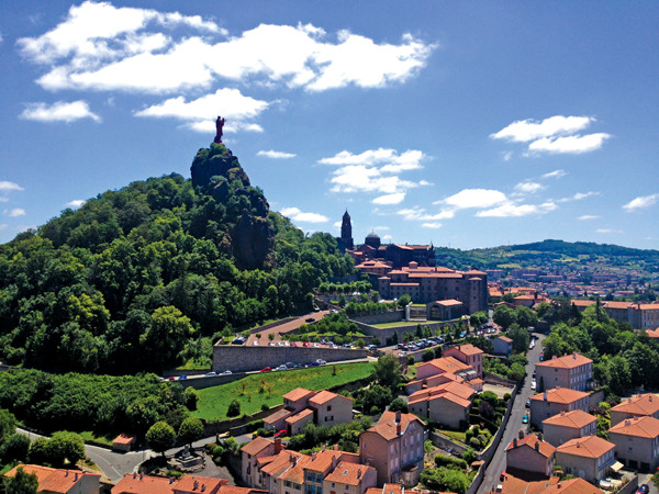
The town of Le Puy has three narrow volcanic necks. One, Rocher Corneille, is capped by an enormous statue of the Virgin Mary and child cast from remelted cannons captured during the Crimean War. Credit: Terri Cook and Lon Abbott.
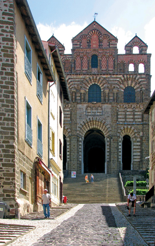
One of Le Puy's volcanic necks hosts the fabulous 11th-century Cathédrale Notre-Dame du Puy. Credit: Terri Cook and Lon Abbott.
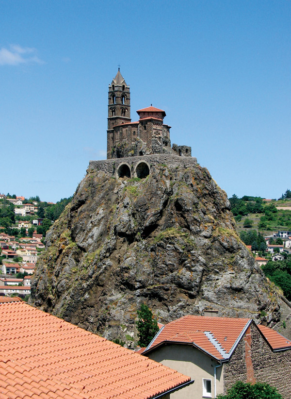
Atop Le Puy's steepest volcanic neck, the Rocher Saint-Michel, sits the town's oldest chapel, the 10th-century Chapelle Saint-Michel d'Aiguilhe, which is accessed via 268 steps carved into the rock. Credit: Terri Cook and Lon Abbott.
Another great adventure originating in the Massif Central is the Via Podensis. This 736-kilometer-long pilgrimage route, established in A.D. 951, journeys from Le Puy-en-Velay to the Spanish town of Santiago de Compostela, the sacred site of the apostle James’ tomb. With three narrow volcanic necks rising above black-and-white cobblestone streets and orange-tiled roofs, it is difficult to imagine a more inspiring setting for the start of this arduous journey.
The first of these volcanic necks hosts the fabulous 11th-century Cathédrale Notre-Dame du Puy, another UNESCO World Heritage Site, whose soaring façade, Romanesque archways and frescoed portal — framed by stone columns imported from Egypt — are an awesome sight. The cathedral dominates the northern end of the lively old town, which is packed with colorful cafés and lace workshops. As the starting point of the Via Podensis, Le Puy was a hub for the manufacturing and sale of fuseau lace, which was considered a necessary adornment for religious clothing. Today, in the shadow of the famous cathedral, you can shop for exquisite samples and watch local craftspeople making lace by hand using intricate lap-looms.
Atop the town’s second and steepest volcanic neck, the Rocher Saint-Michel, Le Puy’s oldest chapel rises high above town. Built of basalt in the 10th century, the Chapelle Saint-Michel d’Aiguilhe is accessed by a series of 268 steps carved into the volcanic neck. The third neck, Rocher Corneille, is capped by an enormous statue of the Virgin Mary and child cast from remelted cannons captured during the Crimean War. Visitors can climb a spiraling staircase inside the statue to reach a set of portholes that offer tremendous views of Le Puy and the surrounding countryside.
Le Puy’s resistant volcanic necks are part of a larger basaltic volcano, now mostly eroded, that erupted atop the Hercynian basement rocks an estimated 2.5 million years ago. Volcanic breccia — characterized by black basalt fragments bound by a brown cement — is a common rock type used for construction in the region, along with white limestone. The breccia formed during a series of explosive maar eruptions that occurred when rising magma came into contact with water and wet sediments in a shallow lake. At the nearby site of Vialette, a maar structure dammed by a basalt flow formed a lake in whose sediments the fossils of 17 species of large mammals have been found, including lynx, mastodons and a slender rhinoceros called Stephanorhinus jeanvireti, for which Vialette is the type locality. You can see some of these fossil discoveries in Le Puy’s Crozatier Museum.
The Chaîne des Puys is a line of more than 75 volcanic hills that erupted from 150,000 to 3,500 years ago. Credit: Terri Cook and Lon Abbott.
The Chaîne's highest point, the Puy de Dôme, is a trachytic lava dome that last erupted about 11,000 years ago. Even kids can hike the 365 vertical meters to its summit, where visitors are treated to amazing views. Credit: Terri Cook and Lon Abbott.
Volcanism in the Massif Central is a relatively recent occurrence thought to be connected to the formation of a large, north-south trending rift system that began to develop across Europe about the same time the Pyrenees and Alps were being uplifted. Some researchers argue that thinning of the lithosphere associated with this extension is responsible for the volcanism in the Massif Central. Using teleseismic tomography, researchers have imaged what they interpret as a hot upwelling beneath the Massif, one of a series of plumes beneath Europe arising from the top of a 400-kilometer-deep layer within the upper mantle and associated with a sequence of young volcanic fields.
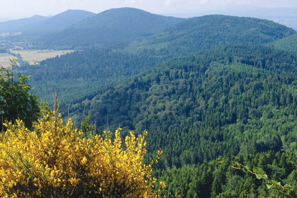
One such field is located in the western Massif Central in the vast Parc Naturel Régional des Volcans D’Auvergne. The park consists of three chains of volcanoes that become progressively younger from south to north. The southernmost chain is the Cantal, which erupted between 11 million and 3 million years ago and includes the remnants of a massive caldera eruption that occurred about 9 million years ago. The central chain is the Monts Dore, which erupted from 2.5 million to 200,000 years ago. The northernmost Chaîne des Puys is the youngest, erupting from 150,000 to just 3,500 years ago.
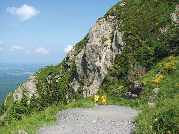
The Chaîne’s highest point, the Puy de Dôme, is a trachytic lava dome that last erupted about 11,000 years ago. You can hike the 365 vertical meters to its summit — an occasional Tour de France stage finish — along the so-called Mule Track, or take the new tourist train to the top. With amazing views of the surrounding cinder cones and dozens of paragliders landing and taking off, it is a perfect spot for a picnic. The informative museum details the puy’s history, including its wide range of roles as a Celtic shrine, Roman Gaul’s largest hilltop temple and current Grand Site of France.
From limestone and lava to lentils and lace, the Massif Central celebrates France’s remarkable geologic and human history.
© 2008-2021. All rights reserved. Any copying, redistribution or retransmission of any of the contents of this service without the expressed written permission of the American Geosciences Institute is expressly prohibited. Click here for all copyright requests.