
by R. Forrest Hopson Thursday, January 5, 2012
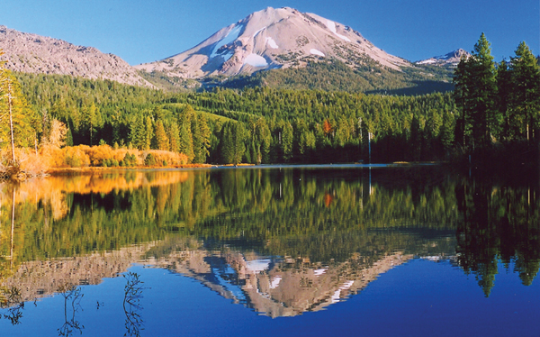
Lassen Peak is the world's largest dacite plug dome. The volcano last erupted in 1921. R. Forrest Hopson
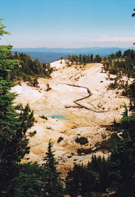
The 6-hectare Bumpass Hell is home to hot springs, mud pots and fumaroles. Rene Rivers, Creative Commons Attribution-NonCommercial-NoDerivs 2.0 Generic
About 300 years ago, one of the plug domes of Chaos Crags collapsed, creating the Chaos Jumbles rockfall deposit. R. Forrest Hopson
For breathtaking volcanic scenery, few places have the variety found in Lassen Volcanic National Park in the Cascade Range of Northern California. The park boasts five varieties of volcanoes: plug domes, cinder cones, lava cones, shield volcanoes and a stratovolcano called Brokeoff volcano (or Tehama volcano). Bubbling hot springs, boiling mud pots and fumaroles in six geothermal fields in the southern part of the park complete the picture.
The park’s main geologic attraction is Lassen Peak, the site of California’s most recent volcanic eruption. From May 1914 to May 1917, the volcano experienced a series of intermittent phreatic eruptions — explosive eruptions of steam and ash caused by the interaction of water and hot rocks or magma — that were punctuated by magmatic eruptions in May 1915. Those magmatic eruptions triggered a small dacite flow, large pyroclastic flow, debris avalanche and massive volcanic mudflows called lahars, which wiped out a 5-square-kilometer area now called the Devastated Area. The volcano finally went silent in 1921.
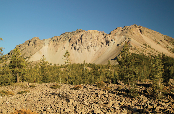
Lassen Peak is part of a group of volcanoes called the Lassen Volcanic Center, which formed in three stages beginning 825,000 years ago. Beginning with the Rockland Stage, a 15-kilometer-wide ring of dacite plug domes and flows arose, followed by an eruption of a rhyolite ash flow tuff and tephra that fell across the western United States and created the Rockland Caldera. Then, during the Brokeoff Stage between 590,000 and 390,000 years ago, the andesitic stratovolcano Brokeoff formed above the caldera. Finally, in the Lassen Stage 300,000 to 1,100 years ago, eruptions produced a 50-cubic-kilometer field of dacite and rhyodacite plug domes on the northern flank of Brokeoff, including Lassen Peak — a dacite plug dome, the largest in the world — 27,000 years ago. These plug domes, informally known as the Lassen domefield, and pyroclastic deposits filled in Rockland Caldera. Ten andesite cinder cones and shield volcanoes along the margins and within the domefield also erupted during this time, producing mixtures of the Lassen domefield and regional basaltic lavas.
In addition to its volcanic features, Lassen has some fine glacial landforms that were created during five Pleistocene glacial advances. Cirques usually occupied by glacial lakes called tarns, deep glacial valleys, glacial polish and striae, and lateral moraines all point to the fact that the park’s volcanic landscape was once modified by glacial ice. For example, glaciers streamed down Brokeoff volcano, creating deep glacial valleys such as Blue Lake and Mill Creek Canyons, and an ice cap covered the Central Plateau. In addition, glacial ice tongues radiated off Lassen Peak. One of them built a terminal moraine at the base of the volcano that is visible from the Lassen Peak Trail.
Lassen Peak Trail is one of many trails in the park. It climbs 550 meters to the summit of Lassen Peak over 4 kilometers. The summit offers great views of Lassen Volcanic Center as well as other Northern California geologic icons, such as Mount Shasta, Medicine Lake volcano, the Klamath Mountains and the Coast Ranges. The best views of the Lassen Volcanic Center, however, can be seen from the summit of the easy 3-kilometer-long Mount Harkness Trail that rises 365 meters. The strenuous 11-kilometer-long roundtrip hike to the summit of Brokeoff Mountain, the erosional remnant of Brokeoff volcano, is also breathtaking, with views of Lassen Peak and the Lassen domefield. The Bumpass Hell hike is an easy 2.4-kilometer-long trail that leads to the largest geothermal field in the park. At Bumpass Hell, several hot springs and fumaroles are spread over 6 hectares. The trail passes by exposures of dacite from Bumpass Mountain and lavas from Brokeoff volcano.
An easier way to experience Lassen’s volcanic features is a 58-kilometer-long drive along California Highway 89, starting south of the park boundary at the junction of California Highway 89 and California Highway 36. Driving north, you will see the entire geologic section of the park in chronological order, beginning with the oldest rocks, the dacite plug domes related to Rockland Caldera. The road then passes through the eroded core of Brokeoff volcano, followed by the Lassen domefield and ending at the distal end of the Chaos Jumbles rockfall avalanche deposit, which formed approximately 300 years ago when one of the Chaos Crags plug domes collapsed. Along the way, you’ll also see glacial till and valleys, landslides and hot springs.
If the varied volcanoes of Lassen aren’t enough to satisfy your geo-appetite, consider taking a-two-and-a-half-hour drive northwest to Shasta-Trinity National Forest, home of Mount Shasta. To learn more about seeing the largest stratovolcano in the Cascades, visit www.earthmagazine.org for an online exclusive about climbing Mount Shasta.
© 2008-2021. All rights reserved. Any copying, redistribution or retransmission of any of the contents of this service without the expressed written permission of the American Geosciences Institute is expressly prohibited. Click here for all copyright requests.