
by Zahra Hirji Tuesday, June 12, 2018
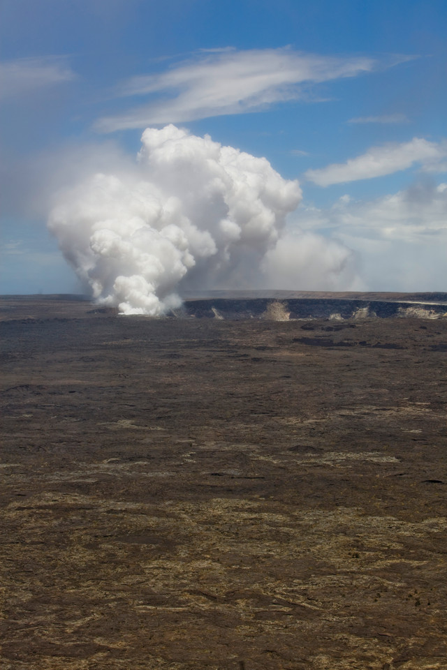
Kilauea's 3-kilometer-by-5-kilometer caldera sits in the middle of Hawaii Volcanoes National Park. The Halema`uma`u crater located within the caldera is currently erupting. Credit: ©iStockphoto.com/joeygil
This past summer, I lived a geologist’s dream: residing in a national park and getting up close and personal with Hawaii’s infamous Kilauea volcano. For hundreds of thousands of years, Hawaii’s Kilauea has been erupting on and off. But on Jan. 3, 1983, the volcano began one of its longest (and largest) eruptions, shooting a fountain of lava hundreds of meters into the air. Twenty-seven years later, the volcano is still alive and kicking — in fact, it’s the most active volcano in the world. For volcanologists, Kilauea is a mecca: an accessible active volcano in a picturesque location. So when I landed an opportunity to volunteer at the U.S. Geological Survey (USGS) Hawaiian Volcano Observatory near Kilauea, I couldn’t refuse.
The Creation of Hawaii
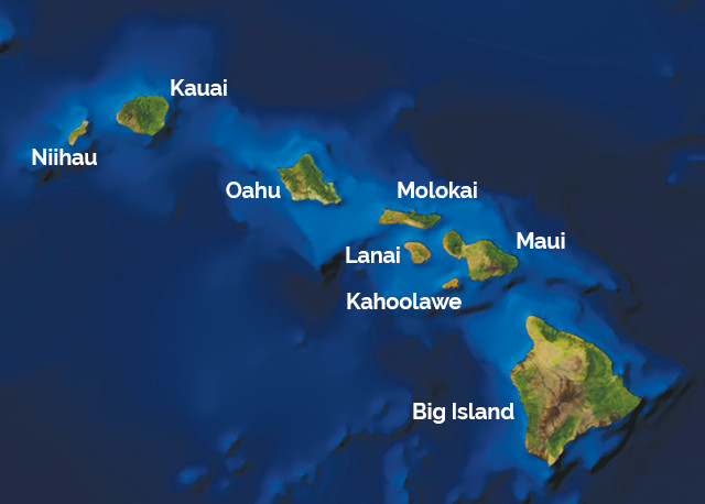
Kilauea is located on Hawaii’s Big Island, one of the eight major islands that make up the Hawaiian chain. The islands were formed by a volcanic “hot spot,” where a large mantle plume brings magma up through the center of the Pacific Plate. As the Pacific Plate moves over the hot spot, new volcanoes (and thus new islands) pop up.
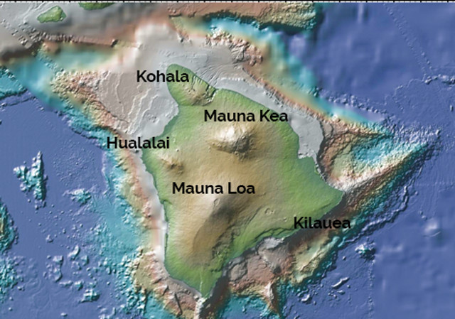
Right now the Big Island sits atop the hot spot. The island has been growing for a little over a million years. It was born from Kohala volcano, which started out as a small vent on the ocean floor. Over hundreds of thousands of years of repeated eruptions, this shield volcano grew into the immense mountain it is today. When land created by the volcano broke through the sea surface, it officially created Hawaii’s Big Island. Since then, the younger Mauna Kea, Hualalai, Mauna Loa and Kilauea volcanoes have all followed the same gradual shield-building process, each adding to the Big Island’s size.
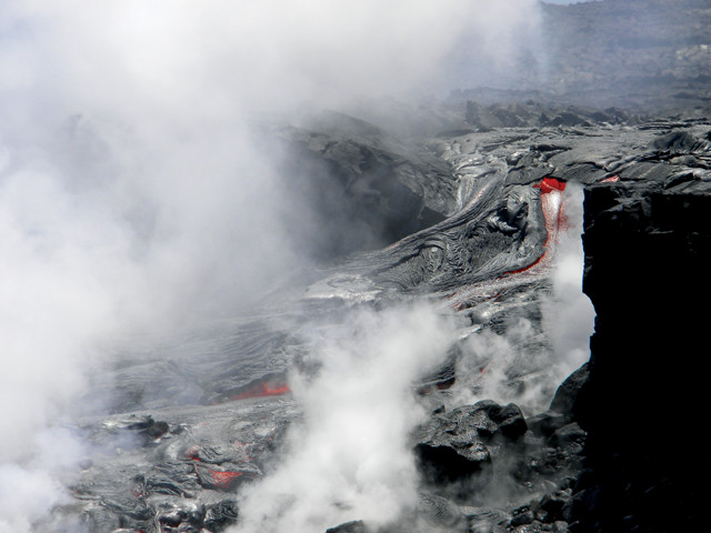
When Kilauea's lava flows into the ocean, it cools and solidifies, adding new land to the Big Island. Credit: Zahra Hirji, USGS
The Hawaiian island chain was formed by a volcanic hot spot. Credit: AGI/NASA
Today, Kilauea is most actively building up the island. When Kilauea’s flows reach the ocean, the lava cools and solidifies, creating new real estate. But the buildup of land is slow because some of the unstable fresh land occasionally breaks off into the ocean, similar to how glaciers calve off icebergs. As of January 2007, Kilauea’s currently ongoing, multidecadal eruption had added 201 hectares to the island’s southern shore, although some of that land has been lost to the ocean.
Some of Kilauea’s volcanic neighbors also have the potential to expand the size of the Big Island. Although Hualalai has not erupted since 1801 and Mauna Loa has not erupted since 1984, they are far from extinct (see sidebar). If and when these volcanoes blow, they will likely cause much more damage than Kilauea’s eruptions. Past lava flows from Mauna Loa — which encompasses half of the Big Island and is the world’s largest volcano — have extended as far as Kona and Hilo, located on opposite sides of the island.
A Walk in the Park
Credit: AGI/GeoMapApp, Ryan et al., 2009
From the sky, Kilauea does not look like much, with a peak only 1,277 meters above sea level. The volcano is nearly invisible, tucked away in the southeast corner of the Big Island, as its four older, more massive volcanic siblings compete for the horizon.
Driving down the one-lane Highway 11 on my way to the volcano observatory last April, I did not even realize that I was on the volcano until I saw a big wooden sign announcing the entrance to Hawaii Volcanoes National Park. Once inside the park, however, the evidence is everywhere: Huge, scattered igneous boulders serve as remnants of past explosive eruptions and steam vents line the road, while gassy, yellowish brown tinted plumes snake high up into the atmosphere.
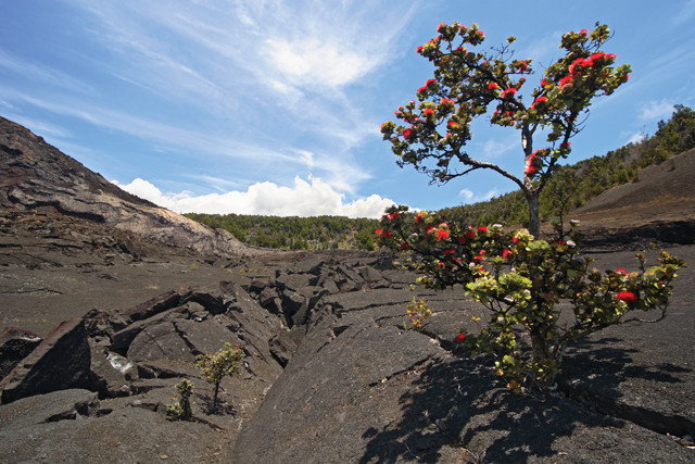
An `ohi`a tree with red lehua flowers grows up through old lava inside the park. Credit: ©iStockphoto.com/photo75
The 5-kilometer-long drive from the front gate to the observatory offers glimpses of the volcano’s caldera, hidden behind a vegetated wall of red lehua-flowered `ohi`a trees. The real breathtaking view, however, is saved for the observatory, which is precariously perched on the edge of the northern caldera rim, only a stone’s throw from the pond of lava that sits deep inside the caldera’s Halema`uma`u crater, one source of Kilauea’s current eruption.
During the last couple of hundred years, the Kilauea landscape has changed dramatically due to the near-constant level of volcanic activity. Eruptions have lasted from only a few hours to a few decades, with each new layer of lava making its mark on the land.
Visitors to the national park can bear witness to these previous eruptions as well as observe the ongoing one. The park encompasses more than 93,000 hectares, with Kilauea’s 3-kilometer-by-5-kilometer caldera standing at its center. Crater Rim Drive encircles the caldera and the adjacent Kilauea Iki crater, making many of the park’s highlights easily accessible by car. However, the section of Crater Rim that goes past Halema`uma`u crater is currently closed due to the buildup of dangerous levels of sulfur dioxide gas, and will likely remain closed as long as the crater is active.
Hiking is probably the best way to experience Kilauea. Kilauea’s caldera used to host vibrant volcanic entertainment: In the 1800s and early 1900s, according to observers’ reports, the caldera put on shows of dancing lava fountains and transient lava lakes. Today, much of the caldera is a dry, barren, rocky place, with only a few stubborn `ohi`a trees sprinkling the floor with color.
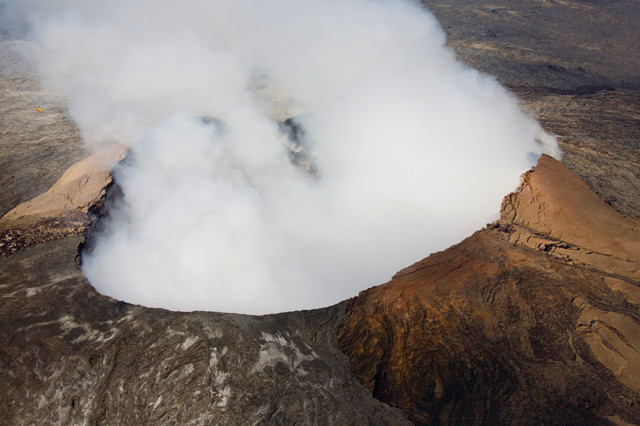
Kileaua has been continuously erupting since 1983. The eruption began south of the caldera in the Pu`u `O`o crater, pictured here. Credit: ©iStockphoto.com/Hoerold Photography
Many of the trails that line the perimeter of the caldera, such as the Byron Ledge Trail and the Crater Rim Trail, provide breathtaking views, where you can see the carnage of historic magmatic events visible in the crater walls and the caldera floor. If you close your eyes, it is easy to imagine the place when it was alive, pulsing with red hot lava, glowing throughout the night.
However, the trails won’t get you close to the center of the caldera’s current action — the small Halema`uma`u crater, located in the caldera’s southern corner. The crater, which has existed for hundreds of years, nearly doubled in size to its present dimensions (900 meters across) during a 1924 explosive eruption. The crater’s most recent eruptive phase began in 2008 (Kilauea’s ongoing eruption initially began in the Pu`u `O`o crater, located south of the caldera in the East Rift Zone). Although the Halema`uma`u Crater Overlook, a 10-minute walk from Crater Rim Drive, is currently closed, you can still see the crater’s erupting plume from the lookout point near the volcano observatory, just off Crater Rim Drive.
The observatory is not generally open to the public. But if you call ahead of time, you may be able to arrange a quick tour to see what the geologists do there. If that doesn’t work out, you can still visit the nearby Jaggar Museum, named for Thomas Jaggar, the MIT geology professor who founded the observatory in 1912. The museum describes the development of the volcano observatory and provides a comprehensive history of Kilauea’s evolution. You can also watch video footage of the Halema`uma`u crater’s active lava pond.
The museum also explains that Kilauea often hosts more than one active crater. For example, the Pu`u `O`o crater in the East Rift Zone is still active. Although the crater is closed to visitors, various trails along the southern part of the park, such as the Napau Trail, provide panoramic views of the beautiful, remote Pu`u `O`o crater.
Meeting Pele
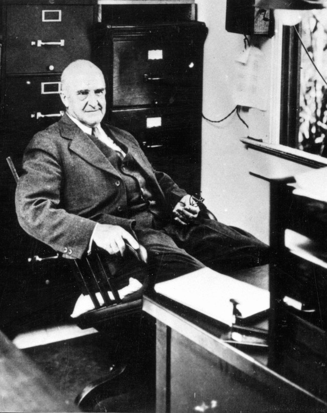
Thomas Jaggar opened the Hawaiian Volcano Observatory in 1912. He was the observatory's director until 1940. Credit: USGS
Hawaiians believe the impetuous Kilauea is embodied by the goddess Pele, a fiery lady with a hot temper. When she gets angry, destruction plagues the land in the form of lava flows, earthquakes and the release of noxious volcano smog, called vog.
Kilauea’s repeated eruptions and displays of power keep the observatory geologists (which included me for the summer) very busy. I had many run-ins with danger and learned firsthand just how powerful the goddess could be. Within 24 hours of landing on the Big Island, I got my first encounter with Pele. Active lava flows were threatening the town of Kalapana, which had last been inundated with lava during the 1990s. As a result, Tim Orr, my boss and the observatory’s head operational geologist for Kilauea, had to pull weekend duty, and I tagged along.
Our task was to map the growth of the lava flow and see just how close it was to a small road that cuts through a residential neighborhood in Kalapana. Using a GPS device, we followed the sinuous margins of the lava. Walking next to a slow, barely moving flow of lava may seem simple, but it’s not. At all. Our journey involved wading through thick brush, navigating around cracked, hot flows (and sometimes on top of flows when other routes proved too precarious), and generally abusing my poor quads. We managed to walk over the lava because much of it had cooled, hardening into a dark crust. But the heat emanating from the still-liquid, glowing red parts was staggering — fresh lava can be as hot as 1,050 degrees Celsius. And the fact that we were covered head to toe in protective gear did not help with the heat.
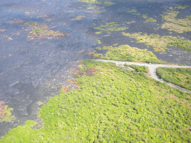
A bird's-eye view of the lava flow field that threatened the town of Kalapana in June. By the end of July, the entire road (shown here) was covered in lava. Credit: Zahra Hirji, USGS
Hiking around the flows, Tim pointed out the difference between pahoehoe (pronounced pa-hoy-hoy) and `a`a (pronounced ah-ah) flows, the two main types of basaltic lava on land. Both types of lava have the same chemical composition, but differ in viscosity and temperature. Pahoehoe flows are smooth or ropey layered lobes of lava, whereas `a`a flows have a rougher, blocky texture and can look like a rolling wave of lava. They also flow much faster than pahoehoe flows. In one of Kilauea’s prior eruptions, for example, `a`a flows traveled 12 kilometers in less than a day; it took pahoehoe flows about three months to cover the same distance.
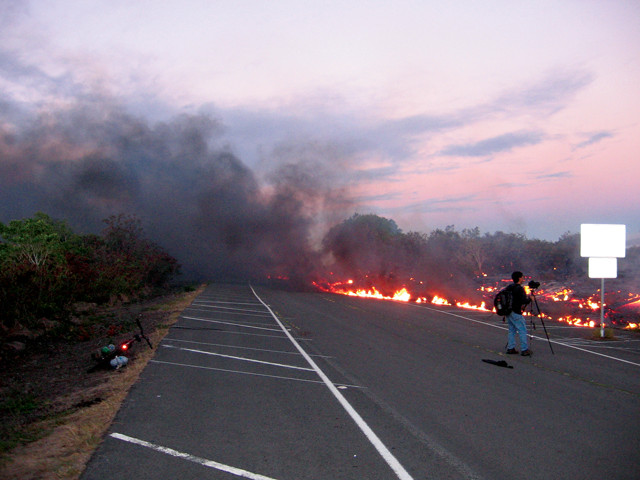
Kilauea's lava flows reach a road near Kalapana on July 17. Credit: Jeanette Renee Bachland
During my first three weeks on the job, I went to these flow fields multiple times a week. The hot lava field became my second office, and I got to know the layout of the place fairly well. In addition to the lava, I encountered methane bursts. When lava ignites vegetation, methane builds up. These methane bubbles randomly burst with a resounding pop. I also had my fair share of run-ins with trees and plants suddenly lighting on fire, trees falling down and lots of smoke. Each time I emerged from a burning “kipuka,” the Hawaiian term for an island of vegetation surrounded by lava, I was covered in sweat and black scratches from brushing up against burning, ashy vegetation.
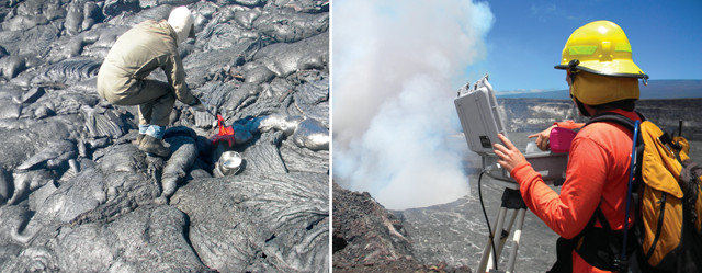
Left: Kilauea research geologist Matt Patrick takes a lava sample while wearing full-body protective gear. Below: Kilauea geology technician Kelly Wooten changes a webcam camera card at Halema`uma`u crater. Credit: Zahra Hirji, USGS
My last two weeks on the job during the end of July were entirely different. With little warning, a new, larger, faster surge of lava erupted from Kilauea. On July 17, lava finally hit the road I had been monitoring all summer. When lava eats up asphalt, thick, noxious black smoke clogs the air. We wore gas masks when maneuvering around the melted road. Then on July 26, Pele took her first victim, a house. This was the first time in a few years that Kilauea’s flows had consumed an occupied structure. Two more houses were nearly enveloped by the lava, but fortunately there were no other casualties. Since then, Kilauea’s tempestuous flow has calmed down.
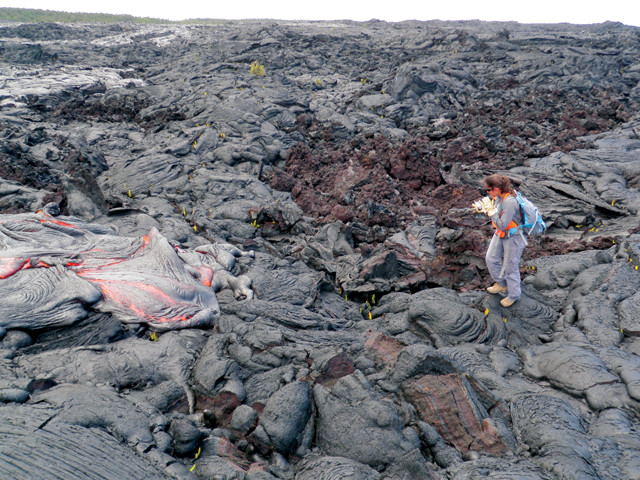
The author, Zahra Hirji, maps an active lava toe at the Kalapana flow fields. Credit: Ryan Ferguson, USGS
At the beginning of my time at the volcano observatory, I was a young geologist with eyes only for the Hollywood version of volcanoes: the smoking craters and the flowing lava. Three months living on Kilauea taught me to open my eyes, and when I did, it was impossible not to see evidence of the volcano in every inch of the island.
© 2008-2021. All rights reserved. Any copying, redistribution or retransmission of any of the contents of this service without the expressed written permission of the American Geosciences Institute is expressly prohibited. Click here for all copyright requests.