
by Debra Hanneman Friday, July 19, 2013
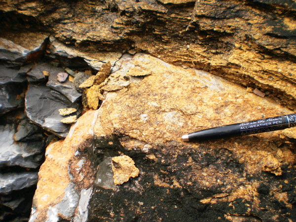
The Moncada Formation, which lies at the Cretaceous-Paleogene boundary, is a 2-meter-thick unit that records the Chicxulub impact event. Abundant shocked quartz and a high iridium concentration lend evidence to the formation's genesis from impact events. The Cretaceous-Paleogene contact in this section is indicated by the pen. Debra Hanneman
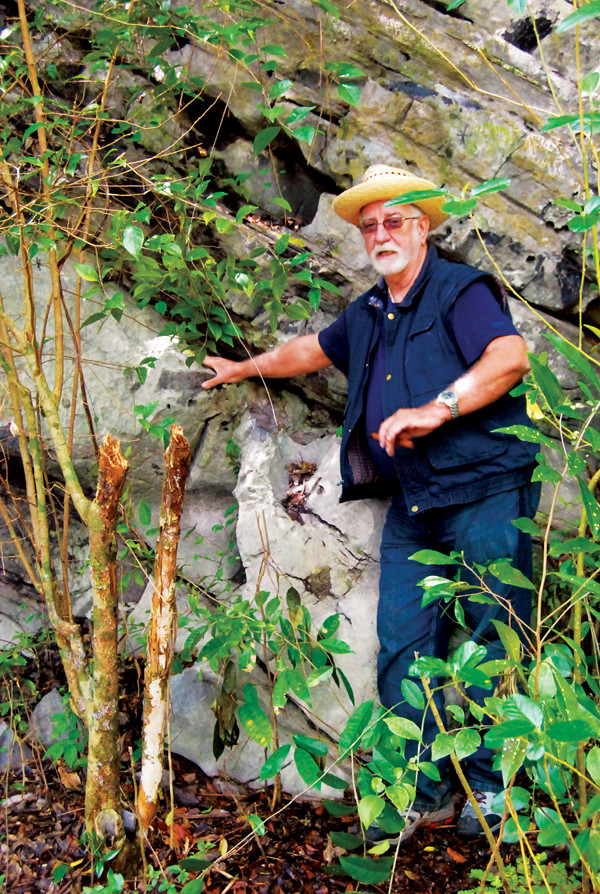
Our geologic guide, Manuel Iturralde-Vinent, shows the contact of Late Jurassic thick-bedded limestone with overlying, thin-bedded to laminated, chert-rich Cretaceous limestone, which outcrops north of Pinar del Río, in Los Órganos near Cueva del Indio. Debra Hanneman
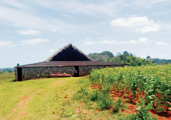
Tobacco is big business in Cuba. A drying barn at a Viñales Valley tobacco farm is shown here. Debra Hanneman
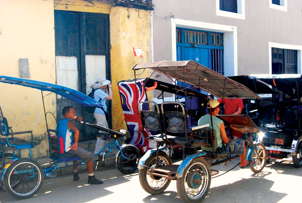
Traveling by bicitaxis is a fun way to see the city of Remedios. Debra Hanneman
It’s not every day that you get the chance to go to Cuba, so when I found out that the Association for Women Geoscientists (AWG) was offering an organized trip there in March 2013, I jumped at the opportunity. The excursion — nearly two weeks of exploration of our southern neighbor’s geology and culture — did not disappoint.
Although Cuba is just 145 kilometers south of Miami, few U.S. citizens get the chance to visit because of the continuing U.S. trade embargo on Cuba, initially imposed in 1960. Travelers from most other countries can readily visit Cuba, but U.S. citizens must work with an organization licensed by the U.S. Department of State to provide “people-to-people” travel to Cuba. These people-to-people visits involve booking a full-time schedule of educational exchange activities for each traveler that will bring about a “meaningful interaction” between the travelers and Cubans.
I traveled as part of a 14-person AWG group that booked our travel through Insight Cuba, a licensed provider of people-to-people travel that took care of the logistical details of the trip (see sidebar below). We spent the first night in Havana and met our guides, including our geology guide Manuel Iturralde-Vinent, a retired curator from the National Museum of Natural History in Havana.
For the next 10 days, our group traveled via tour bus through western and central Cuba. Our daily schedule typically included a morning of geology led by Iturralde-Vinent, followed by people-to-people educational activities arranged by Insight Cuba. Cuba boasts some interesting geology attractions, including everything from unusual Upper Jurassic and Cretaceous deep-water marine rocks that exist because of Cuba’s location with respect to the North American and Caribbean tectonic plates, to readily accessible sedimentary deposits resulting from the Chicxulub asteroid impact event. In addition, Cuba also contains a largely unsurpassed accumulation of oceanic material such as ophiolites and volcanic arc rocks that have helped geologists understand the processes of plate subduction and accretion.
We flew into the capital, Havana, which lies on the country’s northwestern coast where the city has been built up around Havana Bay. Havana was founded in the 16th century, and because of its strategic location, became a key port for the expansion of the Spanish empire into the New World. Old Havana, the historic city center, was listed as a UNESCO World Heritage Site in 1982. Even in bustling Havana, where we spent our first day exploring, some of Cuba’s geology can be seen in local limestone outcrops and in its building stone. For example, the Pliocene Morro algal limestone outcrops beneath the Morro Castle, a fortress built in 1589 to guard the entrance to Havana Bay. Another local limestone, the Middle Pleistocene coral reef limestone of the Vedado Formation, outcrops in a hill immediately north of the historic Hotel National.
Limestone quarried from the Havana shoreline was used extensively as façade and block building materials for several Old Havana buildings such as the Castle of the Royal Force and the Cathedral of Havana. The Castle of the Royal Force, completed in 1577, is an imposing structure that was built to defend the Havana harbor against pirate attacks. The fort was set too far back from the harbor to be an effective defense, and it ultimately became the Governor of Havana’s residence. The Cathedral of Havana — started by Jesuits in 1748 and finished by the city of Havana in 1777 — has a beautiful, undulating façade and is considered to be one of the world’s finest examples of Italian Baroque architecture.
After departing Havana, we headed for Pinar del Río Province in far western Cuba. The red soils and towering limestone hills locally known as “mogotes” make this area world-renowned for its stunning views. One of the most scenic parts of the province, the Viñales Valley, was designated as a UNESCO World Heritage Site in 1999 because of the area’s natural beauty and the inhabitants’ use of traditional agricultural techniques for the cultivation of tobacco and other crops. While in the Viñales Valley, we made one of our first people-to-people stops at a local tobacco farm where we learned about tobacco cultivation and how to roll good Cuban cigars.
Two verdant, low ranges of hills, the Sierra de los Órganos and Sierra del Rosario, border the coastline in this part of Cuba. These “mountains” are part of the fold and thrust belts of the Guaniguanico Terrane. The Sierra de los Órganos have an amazing sequence of exposed Mesozoic marine limestones and Paleogene marine to continental sedimentary rocks. I was astonished to find that geological study of these rocks dates back to the late 1800s when Manuel Fernández de Castro first found Jurassic marine invertebrate fossils on the slopes of Abra de Ancón, a mogote located about 10 kilometers north of the town of Pinar del Río.
In nearby Viñales National Park, we saw the extensive cave systems developed within mogotes of the Sierra de los Órganos. One cave system, Cueva del Indio, located about eight kilometers north of the town of Viñales, exemplifies a mogote cave system formed by both surface river and groundwater action. The cave has several levels, with a subterranean stream that meanders along the bottom. Some of our group passed up lunch and instead took a motorized boat ride along about 700 meters of the subterranean waterway.
The Sierra del Rosario mountains contain mainly Mesozoic limestones that have a deeper-water marine origin than those in the Los Órganos. But it was the Jurassic basalts of the El Sábalo Formation in the northern Sierra del Rosario that really caught my attention. The basalts occur mostly in massive or pillow forms. Our geology guide told us that these basalts probably formed on a continental margin that faced the Caribbean, and can be interpreted as a magmatic event related to the initiation of ocean spreading within the Caribbean. An assemblage of time-equivalent Cretaceous marine fossils now found in the Guaniguanico Terrane that is related to both western Tethys (Mediterranean-northwest European) and eastern Pacific faunas supports this interpretation.
Because my own geological research deals with unconformities (a contact surface between younger and older rocks signifying a missing time interval in the geologic record) and with Paleogene-aged rocks, I wanted to see the major unconformity between Middle Cretaceous rocks and Cretaceous-Paleogene boundary rocks that exists in much of the Guaniguanico Terrane and the overlying, mainly Paleogene, rocks.
The latest Cretaceous to Paleogene rocks, the geologically youngest strata in this terrane, include Chicxulub impact-related deposits, olistostromes (chaotic mixtures of rock and mud that result from submarine gravity slides), and various sedimentary rocks. The Chicxulub impact event occurred 65 million years ago when a large asteroid slammed into the northern Yucatán Peninsula of Mexico, contributing to the end-Cretaceous mass extinction that helped finish off the nonavian dinosaurs. Visible in Guaniguanico Terrane rocks are several remnants of this catastrophic event, such as a 2-meter-thick section of marine sandstone-claystone located near the town of Moncada in the Los Órganos. The unit records impact-related features like abundant shocked quartz fragments, tsunami deposits, and high iridium concentrations, and lies above the major Middle Cretaceous/Late Cretaceous unconformity.
Our people-to-people activities in western Cuba took us to the Biosphere Reserve of Sierra del Rosario, which is located in the eastern part of the Guaniguanico Terrane. This reserve, the oldest in Cuba, was declared a UNESCO Biosphere Reserve in 1985 and covers about 27,000 hectares of mountainous forests threaded with several picturesque rivers. Most “cultural exchange” activity in the reserve is limited to two locations, Soroa and Las Terrazas.
One of the botanists at the Soroa Orchid Botanical Garden led us through the 3.5-hectare garden, situated immediately southeast of the Hotel Villa Soroa complex. The garden hosts 6,000 species of tropical plants and flowers, including 700 species of orchids, 250 of which are endemic to Cuba. Tomás Felipe Camacho, a lawyer and naturalist, started the garden in 1943 to honor his daughter and wife. He cultivated only orchids, adding species from Central and South America to the Cuban endemic varieties. The garden was heavily damaged in 2008 by hurricanes Gustav and Ike, but has been largely restored.
The Las Terrazas eco-community, based on progressive land use ideas and ecological concepts and located about 20 kilometers northeast of Soroa, was another people-to-people stop within the reserve. Las Terrazas was established in 1971 to encourage rural development and reforestation. European settlers cleared the forests that originally surrounded the community for coffee cultivation and cattle grazing. An extensive regeneration project was initiated in 1968, with the bulk of tree planting occurring from 1983 to 1990, when 8 million trees were planted in an area of almost 4,900 hectares. The reforestation effort required terraces to be built to avoid erosion; hence, the community was named Las Terrazas.
The biosphere reserve’s link with coffee is apparent in Las Terrazas. During the peak of the Cuban coffee boom in the 1820s to 1830s, 54 coffee estates were scattered throughout the area of Las Terrazas. We toured the restored ruins of Cuba’s oldest coffee plantation, Cafétal Buenavista, built in 1801, where the plantation’s master house is now a restaurant.
As we drove out of the Guaniguanico Terrane into central Cuba, we crossed the strike-slip Pinar Fault. Geologists have mapped the Pinar Fault for about 110 kilometers from the vicinity of San Cristóbal southwest through El Corojo (near the southwestern tip of Cuba), where it extends into the Caribbean Sea. The fault’s formation resulted from a change in the Caribbean Plate’s motion from north-northeast to the present easterly direction. The Pinar Fault has probably moved recently, but little is known about it. Thus, research on recurrent fault movement is part of a current regional seismicity study undertaken by Cuba’s National Earthquake Research Center.
Geologically, central Cuba is a fold belt composed of very different kinds of rocks formed by plate subduction events. We spent most of our allotted field time looking at sections of mélange exposures in the ophiolite (ancient pieces of oceanic plate now exposed on land) belt in the Santa Clara area.
We also visited a karst landscape developed in Eocene limestone. The limestone, part of a sedimentary belt deformed during the Paleocene to early Upper Eocene because of the Caribbean Plate-North American Plate collision, forms a rubbly-looking surface interspersed with bright red patches of soil.
Our geologic tour of central Cuba was also dotted with people-to-people activities. While in Santa Clara, we stopped at a monument to Che Guevara, the 20th century Marxist leader who played a major role in the Cuban Revolution.
One of our final stops was the city of Remedios, about 40 kilometers east of Santa Clara and close to Cuba’s northern coast. Most historians place the founding of Remedios between 1513 and 1524, making it one of the oldest cities in Cuba.
The city is known for its festival, Las Parrandas de Remedios, which occurs every year from Dec. 16 to 26 and is thought to be the oldest festival in Cuba. Initially begun by a priest to enhance parishioner attendance, the Parrandas is now a competition of extravagance between the Remedios neighborhoods of San Salvador and El Carmen, in which the neighborhoods try to outdo each other with fireworks displays and colorful “carrozas,” or floats. The competition, held on Christmas Eve, begins with the ringing of the Parish Church bells at nine o’clock in the evening. Our glimpse into the festival occurred when we ventured through the city on bicitaxis (a bicycle-like vehicle built to carry passengers) to the San Salvador neighborhood’s warehouse where the displays and floats are constructed. We had a great time there talking to some of the San Salvador Parrandas artists and looking at pieces of their past festival creations.
Our tour finished back in Havana. As we recounted our Cuban travels during our farewell dinner in Old Havana, I was amazed at how much Cuban geology and culture we had seen in such a short period. I look forward to returning and seeing even more of Cuba’s geology.
© 2008-2021. All rights reserved. Any copying, redistribution or retransmission of any of the contents of this service without the expressed written permission of the American Geosciences Institute is expressly prohibited. Click here for all copyright requests.