
by Mary Caperton Morton Monday, November 3, 2014
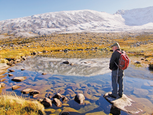
One of many small lochs, also known as a lochans, in the Cairngorm Mountains. Credit: Mary Caperton Morton.
As the birthplace of both modern geology and the sport of mountaineering, Scotland is home to some incredible, inspiring rocks. For a relatively small landmass — less than 80,000 square kilometers — England’s northern neighbor boasts incredible geologic diversity — the product of a 3-billion-year tectonic journey from the South Pole to its current position.
Along the way, parts of the place we now know as rainy, rugged Scotland were a desert, a tropical swampland, a volcanic cauldron and submerged as part of the ocean floor, with the uplifted geologic remnants of each phase subjected to repeated glaciations. Several famous geologists spent their lifetimes studying Scotland’s rocks, and geo-minded travelers can start their Scottish adventures by paying homage to the father of geology in the capital of Edinburgh before heading to the Cairngorm Mountains to visit the peaks that inspired the first mountaineers.
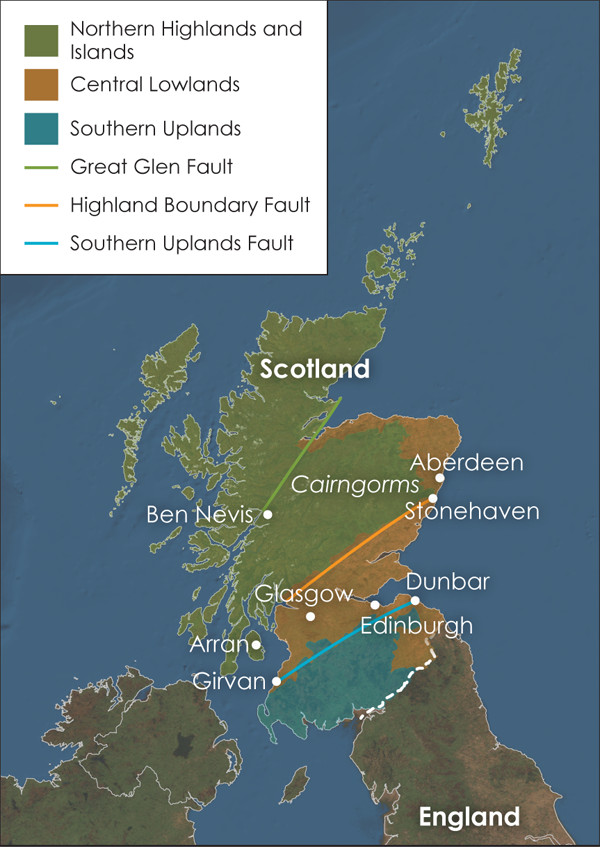
Scotland's diverse geology can be divided into three regions: the Northern Highlands and Islands, the Central Lowlands, and the Southern Uplands. These three regions are roughly separated by three fault zones. Credit: Kathleen Cantner, AGI.
Scotland’s diverse geology can be divided into three regions: the Northern Highlands and Islands, the Central Lowlands and the Southern Uplands, delineated by three massive east-west trending fault zones: the Great Glen, the Highland Boundary and the Southern Uplands faults. After the once-separate landmasses migrated from their ancient positions near the South Pole and the Equator, these major faults stitched the wayward pieces of Scotland together during the Paleogene.
Rising north and west from the Highland Boundary Fault, which runs from Arran to Stonehaven, the Highlands are ancient, composed mainly of rocks from the Cambrian and Precambrian. During the Caledonian Orogeny about 450 million years ago, these basement rocks were uplifted into mountain chains. Later igneous intrusions added even more topography to the rugged landscape, including the Cairngorms. Even after a thorough glacial scouring during the Pleistocene, this region is still home to the highest peaks in the British Isles, including the highest point: 1,344-meter Ben Nevis.
Off the western coast, more than 790 ferociously weathered islands, some the remnants of a long-extinct ring of seafloor volcanoes, reveal a complex network of faults and folds. Here also lie Europe’s oldest rocks: Lewisian gneiss formed 3 billion years ago in the Precambrian.
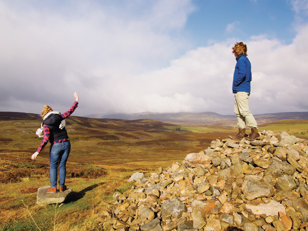
The Scottish Highlands are known for ferocious weather. Here a hailstorm blows through the countryside, near Balmoral, the Scottish home of the Queen of England. Credit: Mary Caperton Morton.
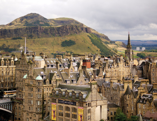
The Lowlands area is a rift valley comprised of Paleozoic-aged rocks, and the underlying coal and iron-bearing layers have long been the cornerstones of Scottish industry and economy. This region also experienced intense episodes of volcanism during the Carboniferous period 300 million years ago. Evidence of this violent past can be seen in Edinburgh, where Edinburgh Castle was built on the remnants of an extinct volcano.
South of the Southern Uplands Fault, running between Girvan and Dunbar, the Uplands are largely composed of deposits laid down between 500 million and 400 million years ago. These rocks were raised from the seafloor when the supercontinent Laurentia collided with the landmass of Baltica, joining Scotland to the landmasses that would later become the British Isles and Europe. Today this region is famous for scenic rolling hills, separated by broad valleys, heavily populated by sheep and crisscrossed by stone walls.
During the Pleistocene glaciations, all of Scotland was covered by massively thick glaciers, which left their marks upon the landscape from the Highlands to the Lowlands. Scotland isn’t finished yet with its globe-trotting journey; plate movements are still carrying the British Isles slowly to the north.
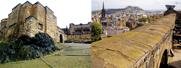
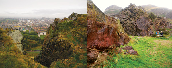
Left: Edinburgh Castle sits on a vent of the Arthur's Seat Volcano. Right: Arthur's Seat as seen from the castle ramparts. Credit: both: Mary Caperton Morton.
Scotland’s capital Edinburgh is built on the bones of a huge volcano. The Arthur’s Seat Volcano was formed about 350 million years ago during the Carboniferous when once-tropical Scotland was positioned near the equator. During the last 2 million years, glaciers carved the remnants of what was a massive edifice, exposing much of the internal workings of the volcano, including the original summit cone and five vents. One of those vents is known as Castle Rock, a natural fortress that hosts Edinburgh Castle.
A hike along the Salisbury Crags to the summit of Arthur’s Seat is a great way to get a crow’s-eye view of Edinburgh, as well as to pay your respects to the birthplace of modern geology. Starting from Holyrood Palace, the Queen of England’s official residence in Edinburgh, a number of paths run through Holyrood Park to the top of Arthur’s Seat.
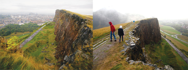
Left: The Salisbury Crags offer spectacular views of Edinburgh, even on foggy days. Right: Several paths run over and under the Crags on their way to Arthur's Seat. Credit: both: Mary Caperton Morton.
The most scenic trail runs atop the Salisbury Crags, a large basalt sill that was emplaced about 25 million years after the volcano was first formed. Scouring glaciers and millions of years of erosion have left 120-meter-tall cliffs that offer panoramic views of Edinburgh.
Geo-pilgrims will want to circle around to the bottom of the crags to visit one of the most historically important layers of rock in all of geology: Hutton’s Section. Along the base of the cliffs, a plaque marks the spot where in 1785 Scottish geologist James Hutton found convincing evidence to refute the “Neptunian” young Earth theory, which espoused that catastrophic events like Noah’s Flood were the primary shapers of Earth.
Here a slab of sedimentary rock was displaced by the upward movement of magma during the intrusive event that formed the Salisbury Crags. As the magma forced its way along the bedding plane, the ends of the slab were turned upward, leaving a vein of glassy crystals along the contact between the layers, with the size of the crystal grains decreasing away from the point of contact.
Top: Edinburgh Castle, seen here right of center, sits atop a second vent of the Arthur's Seat Volcano. Middle: Hutton's Section is preserved along the base of the Salisbury Crags and marked with a plaque. Credit: both: Mary Caperton Morton.
From the pattern of deposition, Hutton concluded that the sedimentary rocks were older than the magma, a realization that helped anchor his theory of Uniformitarianism, which holds that the physical processes operating at present also operated in the past.
Hutton eventually published his ideas in his 1788 paper, “Theory of the Earth,” in the Transactions of the Royal Society of Edinburgh, in which he asserted that Earth was the product of gradual erosion over vast stretches of time. In the 1830s, another Scottish geologist, Charles Lyell, coined the phrase “the present is the key to the past” based on Hutton’s work, which remains one of the basic principles of geology.
Much of the dolerite mined out of the Crags was used to build the city of Edinburgh. Credit: Mary Caperton Morton.
The rocks making up the Salisbury Crags are made of dolerite, which was intensively quarried around the time of the industrial revolution and used for building and paving stones from Edinburgh to London. The original front wall of the cliffs is marked by “Hutton’s Rock,” a small spire of red rock that represented a good example of a hematite seam formed by hydrothermal venting that Hutton lobbied to have saved.
From the Salisbury Crags, several trails wind up to the top of Arthur’s Seat, making for an easy to moderate 4-kilometer round-trip hike. On the summit, the scant remains of prehistoric and Iron Age forts can be found, and an observation disk points the way to a number of other destinations in and around Edinburgh, including the Cairngorm Mountains, 100 kilometers to the north.
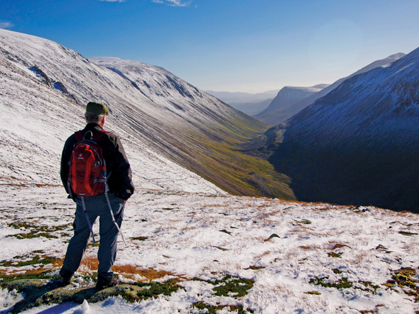
Overlooking the Lairig Ghru, a glacially carved passage through the Cairngorm Mountains. Credit: Mary Caperton Morton.
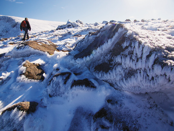
The Cairngorms can be lashed with icy winter weather at any time of year. Credit: Mary Caperton Morton.
The Cairngorm Mountains in the Scottish Highlands are not especially tall, topping out at about 1,300 meters. But their modest heights boast a fierce reputation: Scotland is one of the top destinations in the world for winter climbing on mixed rock and ice terrain, and the region has produced some of the boldest, strongest and technically proficient mountaineers in history, including Hamish MacInnes of Glencoe, who invented the first metal ice axe, and Dave MacLeod, who established some of the most technically challenging climbing routes in Scotland.
Formed from a granite pluton, the Cairngorms sit atop a glacially carved plateau that has long presented a barrier to travel through the region. To this day, the Cairngorms are bisected by a network of ancient footpaths, but no roads. One of the most famous and dramatic routes through the Cairngorms runs through the Lairig Ghru, a deep, narrow, 43-kilometer-long glacially carved canyon that has served as a major trade and migration route from Aviemore to Braemar for hundreds or perhaps thousands of years.
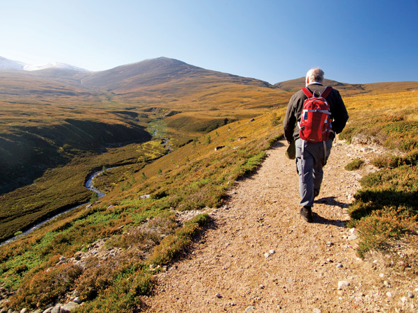
The Cairngorm Ski Center is a great access point into the mountains. This trail runs through the Lairig Ghru. Credit: Mary Caperton Morton.
Exploring the Cairngorms on foot is not for the faint-hearted or tender-footed. The year-round arctic-like weather is dangerously unpredictable and the terrain is intensely rugged. But in spite of the dangers — or perhaps because of them — the Cairngorms have inspired mountain men and women to climb their glacially sculpted granitic slopes since at least the 16th century, when the first ascents of major peaks were recorded.
Scotland is traditionally considered the birthplace of mountaineering in part because the world’s two oldest mountaineering clubs, the Cairngorm Club and the Scottish Mountaineering Club, were both formed in 1889, within a few months of each other, in Aberdeen and Glasgow, respectively. A strong military tradition specializing in mountain and arctic warfare has long strengthened Scotland’s pride in mountaineering sport and culture.
Credit for a number of mountaineering innovations is also given to the Scots, who were among the first to pioneer the use of the ice axe, originally called a Terrordactyl in Scotland, and crampons — ice-traction spikes that strap onto boots — two of a mountaineer’s most important tools for negotiating steep, icy terrain.
You don’t have to be a world-class mountaineer to experience the Cairngorms, however. The region is preserved within the bounds of Cairngorms National Park — the largest park in the British Isles — which maintains hundreds of kilometers of hiking paths suitable for all skill levels. The park also offers skiing, mountain and road biking, horseback riding, fishing and golfing.
Scotland isn’t a big place, but it boasts some of the most diverse and inspiring geology found anywhere in the world. A dramatically scenic, globe-trotting landmass known for being the birthplace of geology and mountaineering, Scotland should be at the top of every geo-traveler’s list.
© 2008-2021. All rights reserved. Any copying, redistribution or retransmission of any of the contents of this service without the expressed written permission of the American Geosciences Institute is expressly prohibited. Click here for all copyright requests.