
by Kathrina Szymborski Monday, June 4, 2018
The Democratic Republic of Congo is not widely known for its geological wonders or natural beauty. Civil war has dominated headlines about the sprawling central African country for decades. Now, after several years of relative peace, visitors are finally trickling in to explore Congo’s untarnished wilderness. Chief among the attractions is Virunga National Park, a UNESCO World Heritage site. In Virunga, active volcanoes and mountainous ice fields loom over savannas, swamps and forests.
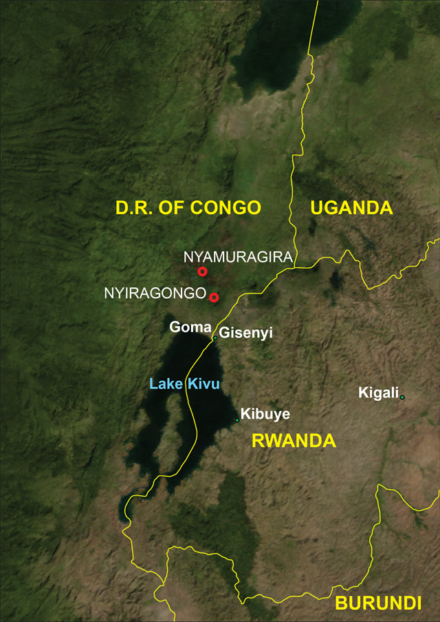
Virunga lies in the western part of the East Africa Rift system on the Albertine Rift. Here, two parts of the African Plate — the Nubian Plate to the west and the Somali Plate to the east — are separating.
The city of Goma in eastern Congo is the best starting point for visits to Virunga. Goma is a dusty but vibrant frontier town on Lake Kivu, just across the Rwandan border. The city has seen more than its share of hardship in recent years. As the capital of North Kivu Province — the site of much fighting during the Second Congo War, which lasted from 1998 to 2003 — Goma has absorbed hundreds of thousands of internally displaced people, and the city continues to suffer from civil unrest and violence. On top of all this, Goma is still rebuilding after the 2002 volcanic eruption of Virunga’s Mount Nyiragongo.
The author hiking up Mount Nyiragongo. Credit: Tom Bradley, www.tom-bradley.com
On the afternoon of Jan. 17, 2002, after months of increased seismic and fumarolic activity, more than 11.5 million cubic meters of lava burst forth from three spatter cones along a 13-kilometer-long fissure on Nyiragongo’s southern and eastern flanks. The lava streams engulfed 14 villages as they poured toward Goma. One stream bisected the nearby airport’s runway and ignited fuel stores. The streams united outside Goma, forming a flow up to 1,000 meters wide and 2 meters deep that cut the city in half and destroyed 14,000 homes. The pressure from the main eruption also created smaller fissures in Nyiragongo’s labyrinthine root system. Molten rock oozed from these gaping holes, some of which opened suddenly in the city itself. Twenty-four hours later, more than 15 percent of Goma lay smoldering.
Today, Nyiragongo’s destruction has been absorbed into Goma’s bustling scenery. Homes have been erected atop the hardened lava, and basalt rocks litter the sidewalks. Life in Goma has settled back into its rough and tumble frontier-town norm.
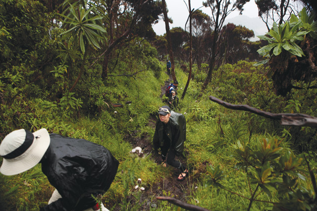
Trekking up the Volcano
Credit: AGI/NASA
Goma’s din quickly melts away once you’re on the road to Virunga. Mount Nyiragongo lies only 19 kilometers north of Goma, just inside the borders of the 7,770-square-kilometer park. The lava’s 2002 path down Nyiragongo’s face is now used as a hiking trail for day and overnight trips to the volcano’s barren summit. The trail has been closed occasionally in the last decade due to security risks and potential for volcanic eruption; check with park authorities when planning a trip.
On the morning of our trek, my friend Frances and I met our fellow hikers and the rangers who would accompany us at the base of the volcano. The hike started gently at an altitude of about 1,500 meters. For the first hour or so, the path was packed dirt weaving through the lush vegetation common to the tropical moist broadleaf forest biome. Small yellow and white butterflies followed us through the forest — Virunga is home to 14 species of butterfly, including the vulnerable cream-banded swallowtail. Soon the trees transitioned into Afro-alpine moorlands and shrublands, spread thin enough that we could spot baboons lumbering in the distance. The trail then morphed into hardened lava waves, at times giving way to streams of small, unstable basalt rock fragments.
The rangers stopped the group often to make sure we were comfortable. During one of these frequent breaks, we noticed what looked like steam rising from under the brush a few meters off the trail. Upon closer inspection, we saw that hot volcanic gas and smoke were billowing through a small opening in the rock where lava had flowed in 2002, about a meter wide and 1.5 meters long. Nyiragongo is known for releasing large amounts of sulfur dioxide through its many vents — up to 50 kilotons per day. The rangers warned us to stand back: If one of us slipped, this hole would take us straight to the churning lava lake at the center of the cone.
The trail became progressively steeper as we climbed, as is typical of a stratovolcano. Unlike most stratovolcanoes, Nyiragongo’s lava is mafic, not felsic. The low silica content of mafic lava gives it a low viscosity, so it travels swiftly and far. The combination of a steep stratovolcano with fluid lava is not found anywhere else on Earth. Low-viscosity lava flows are normally associated with shallow-sloped shield volcanoes, like in Hawaii.
The 2002 eruption was only the latest reminder of the danger posed by this combination. Since 1882, Nyiragongo has erupted at least 34 times. In 1977, one consequence of Nyiragongo’s unique properties came tragically into focus: Low-viscous lava can reach breakneck speeds on its steep flanks. On Jan. 10 of that year, the crater’s entire lava lake drained in less than an hour. The lava gushed through cracks in the crater’s walls and consumed villages at speeds of 95 kilometers an hour, killing up to 1,000 people (the exact number is unknown). After each eruption, the lava lake refills. It currently contains an estimated 8 million cubic meters of lava.
Fog had set in by the time we resumed our hike. A few minutes later, it started hailing. I had forgotten my rain gear, and braced myself for a few cold, miserable hours. Just then, we passed a ranger making his way down the slope. He offered me his raincoat for the night, pointing out that our hike was only getting colder from there on. I gratefully accepted.
Soon I was covered in mud and could feel the first hints of fatigue. This last stretch was the steepest, with no vegetation to grasp at should we need to steady ourselves. One of my hiking companions scanned the precipitous path with wide eyes, and then pointedly told her boyfriend she would never forgive him for this.
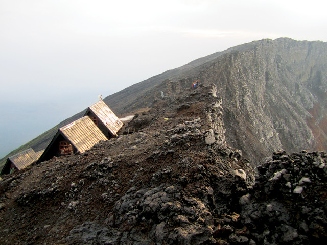
Hikers camp overnight in two-person huts perched on the crater rim atop Mount Nyiragongo. Credit: Kathrina Szymborski
We took a quick break before the final scramble to the summit and the awaiting huts where we would spend the night. The weather was clearing a bit. We could see the cone of an older, smaller volcano protruding from Nyiragongo’s slopes, and the city of Goma in the distance. Behind Goma we could make out Lake Kivu, known as an “exploding lake” for the mixture of methane and carbon dioxide trapped underneath it that could suffocate millions if it leaked to the surface. The tranquility of the view belied the fury of the magma seething under our feet.
The last stretch seemed to last ages. The smell of sulfur from the lava lake hung around us. At almost 3,500 meters, the air was noticeably thinner.
Nyiragongo’s Lava Lake
The view over the volcano’s rim made me quickly forget my discomfort. The crater’s bubbling lava lake — the largest lava lake on Earth by volume — is an agitated, glowing ring. Today, it sits at an elevation of about 2,700 meters, a significant drop from its elevation of 3,260 meters just before the 1977 eruption. It rests in the center of the 2-kilometer-wide crater, encircled by two cooled lava benches. The higher bench is at 3,170 meters, and the lower at 3,000 meters, adding drama and depth to the scene.
Once we had our temporary fill of gaping, we retreated to our hut to change into warm clothes, prepare dinner and retire for the evening. In the morning, a heavy cloud had sunk into and around the crater, completely obstructing the view of the lava lake. Had it been clear, we could have surveyed some of the park’s other natural wonders from afar — the forests, valleys, savannas, lakes, mountains and more volcanoes of the East African Rift Valley.
Under the cloud cover, the world’s last remaining mountain gorillas were ambling through the forests somewhere below us. They live on the slopes of dormant volcanoes in Congo’s Virunga, Rwanda’s Volcanoes National Park, and Uganda’s Bwindi Impenetrable Forest, at an altitude of 2,195 to 4,300 meters. Only about 800 are alive today (see sidebar).
Rwenzori Massif Ice fields
About 60 kilometers to the north of Nyiragongo lies an attraction for visitors with ample time and endurance: the Rwenzori Massif. Here, Africa’s third-highest peak, Mount Margherita, rises almost 5,120 meters above Congo and Uganda. The mountains also host one of the world’s four remaining tropical ice fields outside the Andes.
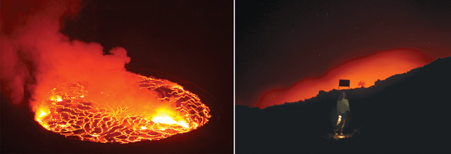
Nyiragongo's lava lake at night. It currently contains an estimated 8 million cubic meters of lava. Hikers camp overnight on the crater's rim, allowing them to view the volcano at all hours. Credit: right: Kathrina Szymborski; left: Tom Bradley, www.tom-bradley.com
Touted by Virunga authorities as “eternal glaciers,” recent research indicates that the ice fields are on track to disappear within 20 years. In 2006, University College London researchers used data from field surveys and satellite images to determine that the combined area of the Rwenzori glaciers had shrunk by half from 1987 to 2006, down to about 1 square kilometer. The researchers indicated that increased local temperatures were likely driving the glacial loss. Temperature records go back only to the 1960s, so it is unclear whether the diminishing ice cover is a long-term trend.
It’s not just the ice fields that are at risk in Virunga. Almost 150 rangers have been killed on the job by militias, poachers or charcoal traffickers since 1998. (Trafficking of charcoal, made from Virunga’s old-growth hardwood trees, rakes in $30 million per year in Congo.) In 2007, seven gorillas were murdered within two months, as revenge for a crackdown on the charcoal trade.
Because of the turmoil, few people have visited what biological anthropologist Emmanuel de Merode once told National Geographic magazine “is arguably the greatest national park on the planet.” Still, Virunga’s rangers are determined to see the park meet its full potential. The rangers we met refused to accept any under-the-table payments. When we asked one for a ride to Virunga’s nearby gorilla orphanage after descending the volcano, he insisted we arrange the transport through official channels.
“We must always think of the good of the park, not of ourselves,” he explained. “It is up to us to protect Virunga’s reputation and share its beauty with our visitors.”
© 2008-2021. All rights reserved. Any copying, redistribution or retransmission of any of the contents of this service without the expressed written permission of the American Geosciences Institute is expressly prohibited. Click here for all copyright requests.