
by Terri Cook Wednesday, September 21, 2016
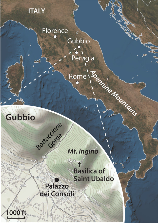
Credit: Kathleen Cantner, AGI ; globe: AGI /NASA.
The Apennines are often called the backbone of Italy. Credit: Terri Cook and Lon Abbott.
The history of our planet is written in the rocks. It was in Italy where the earliest geologists first understood this. As a geologist planning a trip to Italy last summer, I wanted to visit many of the country’s famous geoattractions, including Pompeii, Mount Etna and Tuscany’s rolling green hills. And at the top of my travel list was the small medieval hill town of Gubbio, located in the beautiful Apennine Mountains in central Italy’s Umbria region. Here, studies of the limestone layers just outside the town’s encircling walls produced one of the great geological discoveries of the 20th century: evidence that a 10-kilometer-wide bolide smashed into Earth 65.5 million years ago at the end of the Cretaceous period, extinguishing half the life forms on the planet and finishing off the dinosaurs.
I wanted to see these rocks and ponder the significance of this discovery for myself, as well as explore the beautiful Umbrian countryside, sample the delicious cuisine, and learn more about the rich histories of the many cultures that had lived on this hill. The trip to Gubbio proved a rewarding pilgrimage.
The Apennine Mountains — the backbone of Italy — are a series of parallel mountain chains stretching 1,500 kilometers along the boot-shaped peninsula from the Alps to northern Sicily. Gubbio, located 200 kilometers northeast of Rome, is surrounded by olive- and vineyard-studded Apennine hills composed of a thick sequence of deformed marine limestones deposited on the floor of the ancient Tethys Sea. The Tethys once existed between two great landmasses, Laurasia to the north and Gondwana to the south, following the breakup of the supercontinent Pangaea.
In the early 1970s, Walter Alvarez, now a professor at the University of California at Berkeley, and William Lowrie, now a professor emeritus at the Institute of Geophysics at Swiss Federal Institute of Technology (ETH) in Zurich, came to Gubbio to study a pinkish limestone called the Scaglia Rossa. The formation’s rosy color indicates the iron minerals it contains, which often serve as fossil compasses, recording the orientation of Earth’s magnetic field at the time the layers were deposited. As Alvarez explained in his 1997 book, “T. rex and the Crater of Doom,” the researchers believed they could use this recorded signal to answer a local Mediterranean question: Was the Italian peninsula a microplate? If so, they expected the fossil compasses to show that the peninsula had rotated as a cohesive block during the deformation of the Apennines.
After measuring the magnetization of the cores they had drilled, Alvarez and Lowrie concluded that their samples could not answer the microplate question; the individual layers had slid around too much while the Apennines were being uplifted to preserve this signal. Their disappointment quickly subsided, however, when they recognized that the Scaglia Rossa had instead recorded a 100-million-year pattern of reversals in Earth’s magnetic field — an unusually long and continuous record of global significance.
In the previous decade, geologists had learned that magnetic reversals — occasional flips in the polarity of Earth’s magnetic field — have occurred frequently throughout our planet’s history. The first evidence for these reversals was found frozen in oceanic crust as a series of invisible stripes of “normal” (compass needles pointing north, like today’s field) and “reverse” (compasses pointing south) magnetization symmetrically arranged on both sides of undersea mountain chains known as mid-ocean ridges. When this find was added to evidence of the destruction of oceanic crust in deep trenches, geologists were able to piece together the theory of plate tectonics and understand for the first time that oceanic crust is minted at mid-ocean ridges.
Until Alvarez and Lowrie’s discovery, however, paleomagnetists had no way of dating the reversals — or the timing of the continents’ wanderings — prior to a few million years ago, wrote Alvarez in a later book, “The Mountains of Saint Francis.” Luckily, the Scaglia Rossa is a marine limestone formed primarily from shells of microfossils, mostly single-celled foraminifera, which extract calcium, carbon and oxygen from seawater to build their protective coverings. Over time, the size and shape of the forams’ shell walls, chambers, and openings have changed, creating a succession in the rock record that paleontologists have learned to identify and, in combination with radiometric dating, regularly use to date the rocks hosting them. Thanks to this pairing of fossil compasses and microfossils in the thick Scaglia Rossa record, Gubbio in the 1970s became the first key to dating 100 million years of magnetic reversals and correlating them around the planet.
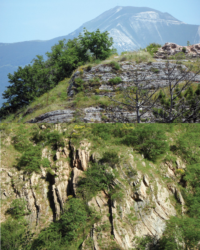
Today in the scenic Bottaccione Gorge, about 1.5 kilometers from Gubbio’s northern gate, you can still see many of the round holes where Alvarez and Lowrie, collaborating with a joint Italian-American team, painstakingly drilled hundreds of cores from the hard outcrops. The marks they drew on the limestone walls as they measured the gorge’s steeply tilted layers centimeter by centimeter are also visible.
The canyon, whose name means “big water barrel” in Italian, hosts a medieval 14th-century aqueduct that bends along the mountainside above the modern road. The roadcuts provide great views of the pinkish Scaglia Rossa, whose translated name — scaglia means “flake,” rossa means “pink” —refers to the ease with which it can be broken off into slabs. Farther up the gorge, the first right-hand turn leads to the Basilica of Saint Ubaldo, perched near the top of Mount Ingino, the peak behind Gubbio. From the basilica, you can walk along the short trail that begins just across the street and takes you past an old fortress and the scaffolding for the 1991 Guinness Book of Records’ “World’s Largest Christmas Tree” before emerging at an overlook with sweeping views down into the gorge.
From this perspective, it is easy to grasp that the Scaglia Rossa in the gorge below is 400 meters thick, with other substantial limestone formations both above and below it. Because these limestones were continuously deposited in seawater deep enough that ocean waves couldn’t disturb the sediment accumulating there, they are high-fidelity recorders of our planet’s history.
While in the field, Alvarez and Lowrie had learned from Italian geologist Isabella Premoli Silva how to recognize a special centimeter-thick layer of clay sandwiched between white limestone strata. It was an important marker because it defined the end of the Cretaceous, and it became the key to unlocking the mystery of what was then known as the K-T (Cretaceous-Tertiary) boundary (now known as the Cretaceous-Paleogene, or K-Pg, boundary).
In addition to being a visually distinctive layer, a distinguishing characteristic of the K-Pg boundary clay is the change in the assemblages of microfossils it demarcates. In the limestone just below the clay layer, you can observe many forams, some as large as sand grains, with just a hand lens. Above it, only a few, smaller forams are present. The forams below the clay are all Cretaceous in age; above, only Paleogene forams are present.
As Alvarez and Lowrie located this key break in outcrop after outcrop across the Apennines, they pondered what had caused the near-extinction of the Cretaceous forams. Based on the thinness of the bed, the forams’ disappearance appeared to be sudden, contrary to the contemporary scientific thinking that earth processes only occurred gradually.
Alvarez discussed the layer with his father, Luis Alvarez, a physics professor also at the University of California at Berkeley. Together they searched for ways to answer what they thought was the key question: How long did the extinction last? One way to answer it was to look at how long limestone deposition, which depends on a steady supply of forams, had been shut down. In other words, how much time did the Gubbio clay layer represent? They envisioned two conceivable answers: Either there had been a brief but heavy input of clay to that part of the ocean, perhaps due to intense storms, in which case the layer would represent a few years of deposition; or, it had taken a few thousand years to build up the clay. But which explanation was correct?
Sensing this could lead to a major scientific discovery, the father-son team searched feverishly for a way to answer this question. Luis Alvarez finally hit upon a chemical solution. He suggested analyzing the clay for iridium, a platinum-group element that is a fingerprint for extraterrestrial material. Because there is a constant sprinkling of meteorite dust all over the planet, by comparing the concentrations of iridium in the clay bed and the adjacent limestone, they reasoned they should be able to calculate the length of time the layer represented.
In 1978, the Alvarezes contacted Frank Asaro and Helen Michel, nuclear chemists at Lawrence Berkeley National Laboratory, who had developed a technique called neutron activation analysis that could detect very low concentrations of elements including iridium. After months of waiting, the Alvarezes received a call from Asaro telling them that something was wrong. He had measured 9 parts per billion (ppb) of iridium in the clay bed, much more than the 0.1 ppb they were expecting even if the clay had accumulated over a period of several thousand years. Where had all the excess iridium come from? After finding a comparable anomaly at Stevns Klint — a coastal cliff on the Danish island of Sjælland that reveals one of the world’s best exposures of the K-Pg boundary — and shortly thereafter in New Zealand, they realized that this anomaly was not peculiar to Gubbio.
The team considered many explanations, including radiation from a supernova explosion, for the anomaly and the associated mass extinction. Additional geochemical tests, however, soon ruled the supernova theory out. In their minds, the only explanation that fit all of the observed facts on the ground was a giant impact. They published this hypothesis in Science in 1980, igniting a firestorm of debate: In the following decade, more than 2,000 scientific papers were published on the topic.
Like the rocks around it, the town of Gubbio, population 33,000, has a fascinating history. It dates to the Bronze Age, when it was an important center for the ancient Umbrian civilization. Much of its current appearance dates to the 14th century, when a thriving tin-glazed pottery industry brought splendor to the town.
In the early 14th century, construction began on the town’s grandest architectural complex, which includes the Palazzo dei Consoli, Gubbio’s symbol and the home of the town’s Civic Museum. This museum houses one of Europe’s most important archaeological records: the Eugubine Tablets, a series of seven bronze tablets inscribed, partially in ancient Umbrian, between the third and first centuries B.C. Found in a field by a farmer in the 1440s, these tablets are one of the most complete documents of the continent’s ancient pre-Roman religions ever discovered, and a visit to the museum to view them is well worth it.
Soon after the last tablets were inscribed, the Romans took over the town, naming it Eugubium. At the end of the first century B.C., they built one of the world’s largest theaters, the Theater of Eugubium, or the Roman Theater of Gubbio, the remains of which still stand just outside Gubbio’s medieval walls.
The town was destroyed by the Goths in A.D. 552, who were succeeded four decades later by the Byzantines and then, in 772, the Lombards. In the 11th century, Gubbio became an independent commune, and in the 12th century, the town flourished under the leadership of Bishop Ubaldo, now Gubbio’s patron saint. Each year on May 15, the town celebrates Saint Ubaldo Day with an unusual race in which three teams, each carrying an hourglass-shaped statue of a saint weighing 280 kilograms, run through cheering crowds from the enormous main square by the Palazzo dei Consoli and up the slopes of Mount Ingino — a feat for which the citizens are known as “the crazies of Gubbio.”
If your pilgrimage, like mine, entails exploring both Earth and human history, and you also enjoy visiting bucolic scenery and sampling world-class cuisine, then Gubbio should top your short list of future geotravel destinations.
© 2008-2021. All rights reserved. Any copying, redistribution or retransmission of any of the contents of this service without the expressed written permission of the American Geosciences Institute is expressly prohibited. Click here for all copyright requests.