
by Mary Caperton Morton Monday, June 4, 2018
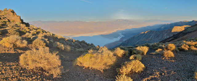
The Dante's View overlook on the crest of the Black Mountains is the best bird's-eye view of Death Valley, short of climbing the 3,367-meter-tall Telescope Peak across the valley. Credit: Mary Caperton Morton
A desert called Death Valley sounds like a place to avoid. Don’t let the ominous name scare you away. Most of the year, this vast and rugged expanse of eastern California is brutally hot, but visit in winter or early spring and you’ll find a surprisingly beautiful and vibrant place.
Named “Death Valley” in 1849 by a band of lost prospectors bound for the Gold Rush, the valley is the largest national park in the lower 48 states, encompassing an area the size of Connecticut. With its diversity of geologic wonders and stunning vistas, to the geo-minded traveler, Death Valley is a hot, dry slice of paradise.
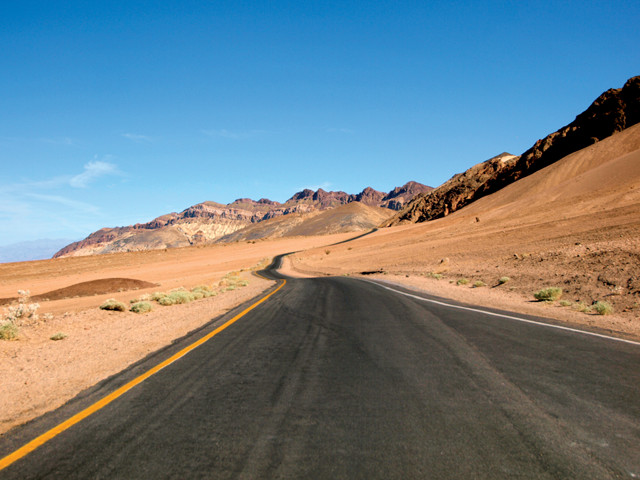
The one-way road, Artist's Drive, loops up and across one of Death Valley's colorful alluvial fans. Credit: Mary Caperton Morton
Behold the Basin and Range
Death Valley National Park is located in eastern California, in the no-man’s land between Las Vegas, Nev., and California’s Sierra Nevada range. These towering mountains, including 4,421-meter-tall Mount Whitney, the highest mountain in the contiguous U.S., create a massive rain shadow to the east, limiting Death Valley to a mere five centimeters of precipitation a year.
Death Valley is enclosed on either side by two mountain ranges, the Panamint Range to the west and the Amargosa range to the east. The two ranges are part of the basin and range topography of steep, elongate mountain chains alternating with dry desert valleys that dominates the West from California to Utah and from Idaho to Mexico.
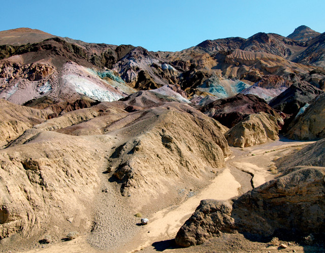
Oxidation of different metals contained in the rocks produces the bright colors of Artist's Palette, seen along Artist's Drive. Mary Caperton Morton
With its exposed terrain and extreme changes in elevation, Death Valley is one of the best places to witness basin and range topography and there’s no better vista than from Dante’s View, a 1,600-meter-high overlook perched atop the Black Mountains in the Amargosa Range.
From Dante’s View, the stark, white saltpan of Badwater Basin — lying at 86 meters below sea level — fills the valley below. Here, Earth’s crust has been stretched and fractured along the Death Valley and Furnace Creek normal faults. Normal faulting creates alternating blocks of down-dropped and uplifted crust, called horst-and-graben, which is characteristic of basin and range topography.
Basin and range may dominate the western U.S., but the underlying mechanisms driving the continued uplift of the mountains and down-drop of the desert grabens are somewhat controversial among geoscientists. The most widely accepted hypothesis for the region’s extensional faulting cites movement along the San Andreas Fault plus subduction of the Farallon Plate and spreading centers beneath the North American Plate. However, tectonics alone does not account for the precipitous elevation changes seen throughout the province. It’s likely that high heat flow may be providing additional uplift by decreasing the density of the lithosphere, weakening the crust and leading to more extreme deformation.
How low can you go?
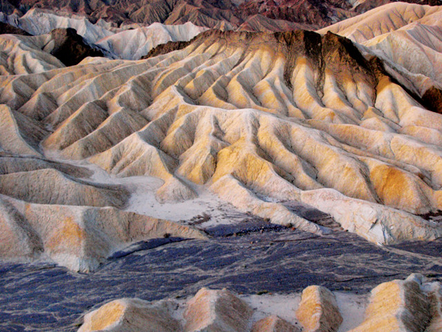
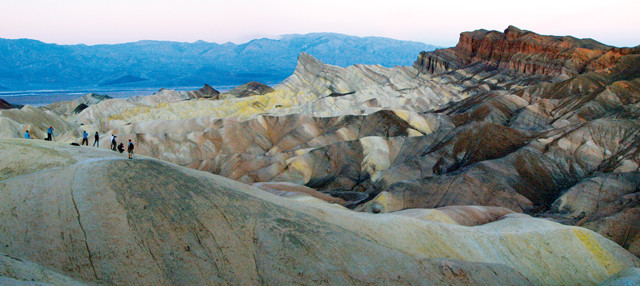
Rapid erosion by rare rainfall sculpted the intricate mudstone badlands at Zabriskie Point. Credit: Mary Caperton Morton
Credit: AGI/NASA
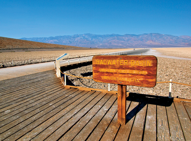
At 86 meters below sea level, Badwater Basin is the lowest point in North America and one of the lowest spots on Earth. Looking across the valley from Dante’s View, Telescope Peak rises 3,367 meters above sea level, making for one of the more extreme vertical rises above local terrain of any mountain in the contiguous United States.
Descending from Dante’s View down to Badwater, a drop of nearly 1,700 meters, temperatures usually increase by 10 degrees Celsius or more. On all but the mildest of winter days, Badwater Basin is oppressively hot. The heat shimmering off the bright white saltpan demonstrates why: The reflected heat rises, but the shape of the valley and the height of the surrounding mountain ranges trap the hot air. As hot air rises, it cools slightly and falls again, all the while being relentlessly heated by the sun, which beats down on the valley’s exposed rocks and salt flats, creating an endless cycle of superheating that’s only slightly tempered by nightfall.
Summer temperatures in Death Valley often exceed 50 degrees Celsius, even at night. The hottest air temperature ever recorded in Death Valley was 56.7 degrees Celsius in July 1913. Death Valley held the record as the hottest place on Earth until it was eclipsed by a 57.8 degrees Celsius day in Aziziya, Libya, in 1922. In the winter, however, temperatures range between 18 and 30 degrees Celsius, with most days unfurling under a bright blue sky.
A small salty puddle is all that's left of Badwater Lake after a long, hot evaporative summer. Credit: Mary Caperton Morton
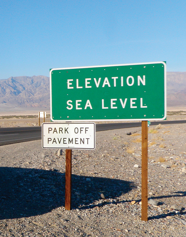
The true lowest point is actually several kilometers out on the white-hot salt flats, but this sign makes a much safer photo-op. Credit: Mary Caperton Morton
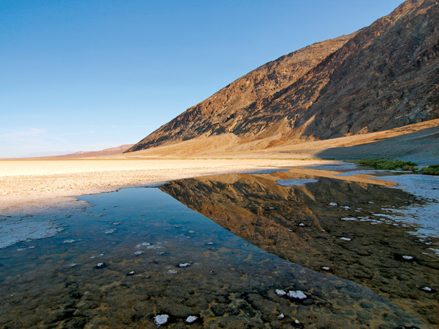
Rain is rare in Death Valley — this region also holds the record for the driest place in North America — but Badwater Basin often holds water drained from the surrounding mountains, though sometimes no more than a puddle.
Some years, most recently 2005, are wet enough for Badwater Lake to form — and the name is apt. The water is so salty it’s undrinkable, though it does host some remarkably salt-tolerant life, including algae and snails.
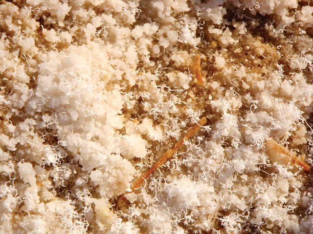
Death Valley’s average annual rainfall of 48 millimeters may sometimes bring water to Badwater Basin, but it’s usually short-lived due to the valley’s annual 3,800-millimeters evaporation rate. This cycle of little rain and major evaporation dates back tens of thousands of years to the Pleistocene, when a series of inland seas collectively known as Glacial Lake Manly flooded the valley floor. About 10,000 years ago, the region began its slow descent into desert. As Lake Manly evaporated, it left behind an abundance of evaporites, including sodium chloride, calcite, gypsum and borax.
The true lowest point is actually several kilometers out on the white-hot salt flats, but this sign makes a much safer photo-op. Credit: Mary Caperton Morton
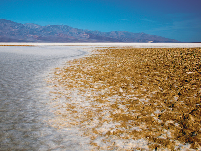
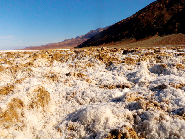
Badwater Basin's salt flats cover 1,300 square kilometers of the valley floor, making it one of the largest salt flats in the world. Credit: Mary Caperton Morton
Death Valley's salt flats are mostly made up of sodium chloride, but other evaporative minerals like calcite, gypsum, and borax are also found. Credit: Mary Caperton Morton
When venturing out onto the salt flats at Badwater Basin, be sure to take water and wear a hat and sunglasses for the walk; the salt flats are a searing hot place for a hike. On the boardwalk over the usually puddle-sized Badwater Lake, you’ll see a sign marking the lowest point. The true lowest point is several kilometers to the west, but the sign makes for a safer photo-op. Turn around to see another famous sign: the human-made sea-level mark on the cliff high above the parking area.
Rock Paint and White Gold
The name Death Valley conjures up very bleak visions, so first-time visitors are often awestruck by this desert’s vivid colors. For thousands of years, the people of the Timbisha tribe thrived here, migrating seasonally between the valley floor and mountains. They called this place Tumpisa, or “rock paint,” after the red ochre paint they made from clays abundant in the valley.
One of the best places to experience Death Valley in all its multicolored glory is Zabriskie Point, preferably at sunrise. Here, Death Valley’s ancient history of inland lakes, which left behind layers of fine-grained silt and clays that eventually solidified into mudstone, is on display. Most days, Zabriskie Point is bone dry, but during rare rainstorms, this soft rock erodes readily, creating intricately carved badlands. When the rising sun hits the sinuous formation’s vivid bands of red, brown and yellow, the colors are among the most brilliant of any desert landscape.
Zabriskie Point is known for its spectacular colors, especially at sunrise. Credit: Mary Caperton Morton
Death Valley’s technicolor terrain continues to the south at Artist’s Palette, a stunning sweep of bright pink, green, purple and blues. The colors can be seen from Artist’s Drive, a one-way loop road that runs up and across a massive alluvial fan created by flash floods eroding debris from a deep canyon in the Black Mountains to the east. The unusual colors here are the result of chemical weathering of different metals found in the rocks. The reds and pinks come from oxidation of iron-rich hematite; the greens are from mica-rich volcanic ash deposits; and the purples from manganese.
Red clay may have been of sacred interest to the Timbisha, but Europeans came to Death Valley looking for gold and silver. Lead, zinc, antimony, fluorite, cinnabar, epsom salts, mercury, tungsten, copper, talc, sodium chloride and manganese have also been found here, but the only rock ever mined in commercially successful quantities is borax. Nicknamed white gold, borax is a mineral with a wide variety of uses in detergents, cosmetics and industrial manufacturing processes.
Much of Death Valley's floor lies at or below sea level. Credit: Mary Caperton Morton
In the 1880s, the Eagle Borax Works, Pacific Coast Borax Works and Harmony Borax Works opened in Death Valley. Harmony Borax Works famously employed twenty-mule team wagons to haul borax out of the valley to Mojave, a sight immortalized by black and white photos on the front of the Twenty-Mule Team Borax Soap box. At the height, companies were mining up to three tons of borax a day.
In 1933, Death Valley was declared a national monument, but mining was allowed to continue. In the late 1970s, after open-pit and strip mining began to visibly scar the land, Congress passed the Mining in the Parks Act, which closed Death Valley to new mining claims and banned open-pit mining.
Underground mining continued on a more restrained scale through 1994, when Death Valley became a national park, and finally ceased in 2005, when the last underground borax mine was closed. Relics from the early mining days, including two of the twenty-mule team wagons, can still be seen around the park, as well as scars and equipment from the more contemporary open-pit mines.
To get an idea of the hot, hard life of a Death Valley borax miner, walk the short interpretive trail around the ruins of the Harmony Borax Works and visit the privately owned Borax Museum, located at Furnace Creek.
Hiking and Driving Off The Beaten Path
As with most national parks, many of the attractions in Death Valley, including Dante’s View, Badwater Basin, the Devil’s Golf Course and Mesquite Flat Dunes, can be seen from the road, but if you’re prepared, getting off the paved path into a more remote section of the park can be tremendously rewarding. Hiking in Death Valley may seem intimidating, but in the right weather with the right supplies, it’s the best way to see the park.
One of the more remote and unique places to visit in the park is Racetrack Playa, a dry lakebed with an almost perfectly flat surface made up of fine sediments of silt and clay, famous for its mysteriously moving rocks. The drive to the Racetrack involves negotiating 45 kilometers of four-wheel drive, high-clearance roads, which may explain why nobody has ever actually witnessed the rocks moving across the dry lakebed.
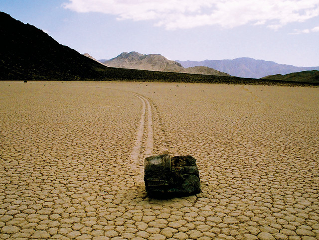
Racetrack Playa is famous for its mysteriously moving rocks. Credit: ©Tahoenathan, Creative Commons Attribution-ShareAlike 3.0 Unported
Rare rains bring a huge volume of water draining from the surrounding mountains onto the playa. When wet, the playa’s fine-grained sediments quickly turn to soft, slippery mud. The most likely explanation for the moving rocks, some of which weigh several hundred kilograms, is that during storms, strong winds slide the rocks across the slippery lakebed, leaving long, smooth trackways. Other explanations include ice, force fields and, of course, alien shuffleboard.
A land of extremes
Death Valley may be a land of extremes, but the extremes are part of what makes this extraordinary place worth a visit. Despite its hardships, people have been drawn to this valley for thousands of years. Whether you’re looking to find wide-open vistas, striking desert scenery or to check off a few superlatives on your bucket list, Death Valley — the driest, hottest, lowest spot in North America — is spectacular, no matter what it’s called.
© 2008-2021. All rights reserved. Any copying, redistribution or retransmission of any of the contents of this service without the expressed written permission of the American Geosciences Institute is expressly prohibited. Click here for all copyright requests.