
by Laurie J. Schmidt Thursday, January 5, 2012
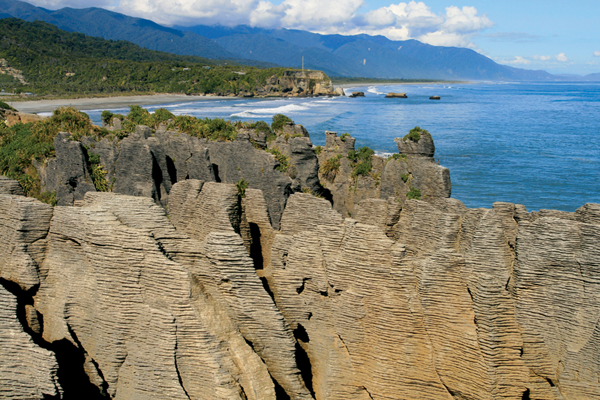
The limestone layers of Pancake Rocks with a view of the rugged West Coast near Punakaiki. Laurie J. Schmidt
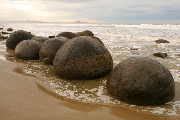
The sedimentary Moeraki Boulders lie scattered along the Koekohe Beach on New Zealand's Otago Coast. Laurie J. Schmidt

Wharariki Beach's surreal vista of arches and caves. Laurie J. Schmidt
New Zealand has a reputation for extreme adventure — sky diving, jet boating, bungee jumping and even “zorbing,” which sends you rolling down a hill inside a transparent plastic ball. But beyond the adrenaline sports, you’ll find unique geologic features in landscapes ranging from volcanoes and alpine peaks to beaches and rainforests.
New Zealand comprises two main islands, the North Island and the South Island, as well as many smaller islands. The country straddles two tectonic plates — the Pacific and the Australian — that are colliding at an angle and constantly shifting. This precarious location makes New Zealand vulnerable to natural hazards, including volcanic eruptions, tsunamis and earthquakes like the magnitude-6.1 quake that struck Christchurch on Feb. 22.
The tectonically active landscape also provides visitors with a long list of volcanic features to see, such as the Taupo Volcanic Zone and Rotorua’s geothermal features on the North Island. But with almost 16,000 kilometers of coastline, New Zealand is also home to a variety of geologic wonders shaped by wind and waves. A great way to experience New Zealand’s diversity of sea caves, sand dunes and other coastal formations is on a trip around the perimeter of the South Island.
Most likely, your arrival on the South Island will land you in Christchurch. From there, head south (renting a car is the best way to tour the island) and continue in a clockwise direction around the island. About 280 kilometers south of Christchurch near the town of Hampden, hundreds of large spherical boulders lie scattered along a stretch of Koekohe Beach on the Otago Coast. Originally formed in ancient seafloor sediments, the boulders are made of mud, silt and clay. Each boulder weighs several tons, with diameters up to 2 meters. The Moeraki Boulders, as they’re called, are considered to be one of the world’s prime examples of septarian concretions — concretions that contain angular cracks. Through a process that is not well-understood, the cracks (septaria) radiate outward from the center of the boulders and are typically filled with yellow calcite crystals. Perhaps most impressive are the places where erosion has exposed boulders that are still embedded in the mudstone, giving visitors the opportunity to see erosional processes at work. A short walk to a viewing platform provides a good wide-angle view of the boulders, or you can walk on the beach for a closer look.
As you continue south from Hampden, consider making a stop in the Dunedin area, where you can take a day trip to the Otago Peninsula for a guided tour of a yellow-eyed penguin reserve and a visit to the world’s only mainland albatross breeding colony.
South of Dunedin, you’ll leave the main highway at the town of Balclutha and continue on the Southern Scenic Route to the Catlins, one of the South Island’s least visited but most dramatic regions. Near the Tautuku Peninsula, a 20-minute walk through forest and along Waipati Beach brings you to the 30-meter-tall Cathedral Caves, a series of connected sea caves carved into sedimentary rock. Sea lions frequent the area, and if you’re lucky enough to see one, keep your distance — sea lions can become aggressive if they feel threatened. If you want to explore the inner caves, take a flashlight (or “torch” as flashlights are called in New Zealand) and check the tide schedule first, as access is limited to two hours before or after low tide.
A cozy lodging option in the Catlins is Hilltop Backpackers in Papatowai, a seaside village located a short drive from the Cathedral Caves. The house sits on a hill in a pastoral setting overlooking the scenic Tahakopa Bay and has a well-equipped kitchen for guests to share.
Heading north from the Catlins via Queenstown and Wanaka brings you to the Southern Alps, the highest mountain range in Australasia. If you were dropped by parachute into this section of the South Island, you’d swear you were in the Colorado Rockies or the French Alps. It’s hard to believe the ocean is just on the other side of the peaks.
Considered the “backbone” of the South Island, the Southern Alps run 450 kilometers from Haast Pass north to Arthur’s Pass, with elevations varying from 900 to 3,050 meters. The Alps are one of the most rapidly rising mountain ranges in the world (up to 7 millimeters per year), and are relatively young, geologically speaking, having only emerged within the last 5 million years as the Pacific Plate collides with the Australian Plate.
You’ll cross the Southern Alps via the scenic Haast Pass Highway, and just past the town of Makarora are the must-see Blue Pools. Here, a maintained gravel path and boardwalk take you through native beech forest to a viewing platform overlooking deep blue pools of glacial meltwater. The pools are so clear you can see straight down to the bottom, where brown and rainbow trout often feed. Getting to the Blue Pools is half the fun, as the trail takes you over a suspension bridge hanging high over the Makarora River. It’s an easy walk with a round-trip distance of less than two kilometers.
You’ll cover a substantial amount of ground en route to the next destination, driving 440 kilometers along the South Island’s West Coast. With a population of only about 30,000 people along a 560-kilometer-long stretch of coastline, the remote West Coast offers a journey through native bush, rainforest, glaciers and rugged coastlines. If possible, plan to spend at least two to three days driving this section, as many New Zealand travelers have regretted not allowing for more time to explore this area.
One of the main attractions in this region is a geologic feature known as the Pancake Rocks near the town of Punakaiki. Here, limestone formed when the remains of dead marine life were deposited on the seafloor about 30 million years ago. As individual limestone strata were repeatedly overlain by softer mud and clay, a layering effect resulted. Coastal erosion by water and wind then carved away the softer layers, giving the rocks their unique “pancake” look. A 10-minute stroll on a paved path takes you through ferns and nikau palms and gives you a close-up look at the rocks and spectacular views of the western coastline. During high tide you’ll also see blowholes in action, when blasts of seawater burst through vertically eroded holes in the pancake formations.
For a unique lodging experience, consider staying at Te Nikau Retreat in Punakaiki. Set in a rainforest, this friendly backpacker lodge offers a unique collection of sleeping options, from dorm beds to private cabins. For a real adventure, request the Stargazer unit — a rustic tent-shaped structure with a glass roof for looking at the stars from your bed.
From Punakaiki you’ll continue north and then turn west on Highway 6, traveling about 250 kilometers to reach two unique areas in the Golden Bay region. At the northern tip of the island, Farewell Spit — the world’s largest sandbar — extends about 30 kilometers into the Tasman Sea. Geologists think the spit was created as strong winds and currents brought sands down from the Southern Alps and deposited them at Golden Bay. The spit’s sand dunes provide habitat for some 80 species of wetland birds, including gannets, godwits and royal spoonbills. To visit the spit, take one of the four-wheel drive safaris that operate daily from the town of Collingwood. The tours range from two to six hours and include stops at a historic lighthouse that you can climb for an aerial perspective, a sand hill that offers a panoramic view of the ocean and a gannet colony.
After you’ve retrieved your own vehicle in Collingwood, there’s another treasure in store for you — one that may not stand out on a road map. Drive about 25 kilometers north to Puponga, where you’ll find a gravel road leading west. At the end of the gravel road, park your car and take an 800-meter walk over grassy hills and farmland to one of the most surreal coastal landscapes anywhere: Wharariki Beach. Here, the action of water and wind has carved sedimentary rock bridges, arches and caves bordered by massive sand dunes. As a bonus, groups of fur seals often play here, and you can watch them frolic in the tidal pools. (Don’t harass them or get too close, as they are known to bite.) The best time to visit Wharariki is at low tide, when you can walk the entire length of the beach.
Limited lodging while visiting Farewell Spit and Wharariki Beach can be found at Collingwood and Tanaka, but more options are available in the larger town of Motueka, about 80 kilometers south. Motueka is also a good base for a trip to New Zealand’s most visited national park, Abel Tasman. The highlight here is the 50-kilometerlong Abel Tasman Coastal Track that runs along the park’s coastline. Water taxis will drop you off at various bays along the track and you can then hike back, taking in scenery that alternates between white sand beaches, bays and inland bush. If you have time, you can hike the entire track in three to five days, camping along the route or staying in backpacker huts.
From Golden Bay back to Christchurch, worthwhile stopovers include the magnificent isles and sauvignon blanc vineyards of Marlborough Sounds, as well as the seaside town of Kaikoura. If you have time to spare before you depart Christchurch, consider a day trip to the historic French town of Akaroa on the Banks Peninsula — just a one-hour bus ride or drive from Christchurch center. The peninsula is made of the remnants of two composite shield volcanoes, and scenic Akaroa Harbour is the flooded crater of one of the volcanoes.
Despite the devastating earthquake in Christchurch earlier this year, New Zealand is up and running and ready for visitors. The tourism dollars will actually help fund New Zealand’s recovery.
© 2008-2021. All rights reserved. Any copying, redistribution or retransmission of any of the contents of this service without the expressed written permission of the American Geosciences Institute is expressly prohibited. Click here for all copyright requests.