
by John Van Hoesen Wednesday, June 6, 2018
The prospect of traveling to Italy might conjure romantic thoughts of stucco-covered villas surrounded by terraced vineyards, ancient visages carved in marble, fountains gurgling in cobblestone piazzas, and pasta smothered in tomato and basil. However, when I was asked to spend a semester teaching in northern Italy, these were not my first thoughts. As a geologist, I instead pondered the Dolomites in alpenglow, the exposure of the iridium-bearing Cretaceous-Paleogene boundary (formerly known as the K/T) in Gubio, and the possibility of visiting some of Italy’s famous volcanoes — Mount Vesuvius and Mount Etna — to the south.
To say the geology of Italy is diverse is an understatement tantamount to saying Italians like wine. This geologic diversity is the result of an ongoing tectonic tarantella.
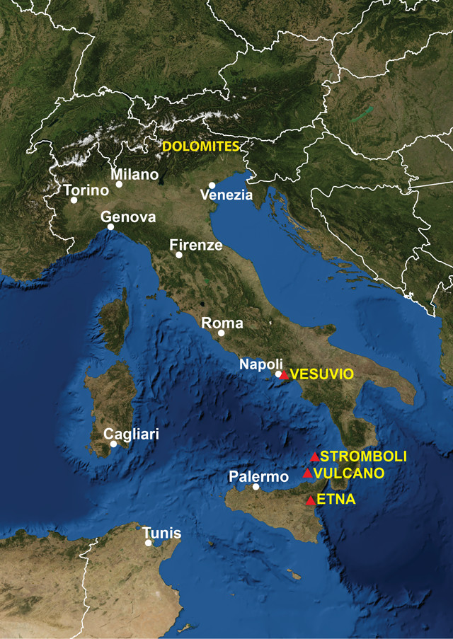
Credit: AGI/NASA
The impressive Alps, which stand like a castle fortification along the northern Italian border, began forming approximately 100 million years ago when the Eurasian and African plates collided. In fact, much of northeastern Italy is composed of “immigrant” rocks that were once part of the African Plate. The collision of the plates also spurred the uplift and exposure of the Dolomites, which offer spectacular exposures of ancient reef complexes.
Approximately 50 million years ago, the Apennine Mountains began forming. Composed primarily of marine sedimentary rocks with rare igneous intrusions and exposures of older metamorphic basement rocks, the Apennines dominate the central Italian landscape, extending southward from the Po Basin to the ankle of the “boot.”
In the south, the more recent volcanism associated with Mount Etna and Mount Vesuvius occurs because the African Plate is still subducting under the Eurasian Plate. These varied processes sculpted the Italian landscape, which prompted early scholars to develop seminal ideas in geology.
Teaching Geology in a Poet’s Stronghold
We spent the spring semester at Brunnenburg Castle in the Südtirol region of northern Italy. This former residence of American poet Ezra Pound — now home to his descendants, the de Rachewiltz family — is nestled in the foothills of the Alps near the dominantly German-speaking village of Dorf Tirol. The castle grounds feature vineyards and fruit trees and stunning views of the Vinschgau and Etschtal valleys.
The area is primarily underlain by metamorphic crystalline rocks of the Ortler Range, with smaller exposures of Tertiary tonalite and Permian volcanics. Glacial deposits of varying thickness mantle the landscape, and till is exposed in streams dissecting the steep valley walls. These valleys often feature a unique landform called earth pyramids — or Erdpyramiden — that form in the dense till when small rills expand into gullies and isolate fins of compacted sediment. Boulders then act as natural umbrellas, protecting some of the fins while the surrounding till preferentially erodes, leaving behind spires that often resemble the Vatican Obelisk. However, the most spectacular topography in this region is exposed in the Dolomites, 35 kilometers to the southeast, where sheer carbonate cliffs and pinnacles now stand as monuments to a former sea.
A Journey to Mount Etna
Although I have long been fascinated with the Dolomites — and they were so close to the castle — our mid-semester break was scheduled during early April when higher elevations are inaccessible. As I contemplated my travel options, I had a flashback to my earliest memory of wanting to visit Italy: reading Jules Verne’s “A Journey to the Center of the Earth” when he described the rapid ascent of Professor Von Hardwigg and his companions through a volcanic vent on the island of Stromboli. With this in mind, I charted a trip that would take me to Mount Etna, across the Tyrrhenian Sea via the Aeolian Islands of Vulcano and Stromboli to Naples and the infamous Mount Vesuvius, and then bring me back north through Rome and Tuscany on the return trip.
Following in the footsteps of the early Greeks and Romans, I traveled to Sicily via Palermo and then on to Catania, albeit by airplane instead of chariot. I landed after sunset and decided to combine my exploration of Italian geology and culture by visiting the Agora food and wine bar, located in a dimly lit lava tube approximately 18 meters below the surface with a freshwater stream trickling by the tables. I then spent the night at the Catania City Center Hostel in the “volcano” room and was pleasantly surprised in the morning by a wonderful snowcapped view of the tallest and most active volcano on the European continent.
The volcano tour I scheduled through the hostel first traveled north through the city and up a wonderful ecological succession exposed on the southern flanks of Mount Etna. At lower elevations, the landscape is dominated by Mediterranean scrub and extensive stands of carob and olive trees, transitioning into holly and turkey oak that share space with thriving chestnut forests. In the higher elevations, you can also find Corsican pine, Etna birch and Etna broom. The landscape was primarily a mosaic of younger black basalt, older basalt encrusted with gray lichen, and light brown skeletons of deciduous trees set against a backdrop of dark green pines.
As we drove higher across a patchwork of variously aged lava flows riddled with lava tubes, the landscape was stripped clean of even the hardiest pine tree. We crossed paths with a red fox seemingly happy in this stark landscape. Our highest destination on Mount Etna was Rifugio Sapienza — an alpine oasis consisting of small mountain huts that host a restaurant and hotel. From the Rifugio you can hike along the rim and down into three cinder cones — Monti Silvestri, Monti Calcarazzi and Montagnola — created during an eruption in 1892. During the summer months, you can hike, hire an off-road tour guide or take the cable car to the summit craters for views of the Bove Valley and the Tyrrhenian and Ionian seas.
A Journey to Vulcano
The next day I left the mountain where Odysseus fought a Cyclops and boarded a hydrofoil to the Aeolian Islands, named for the Greek god of wind, Aeolus. The view from the port includes a magnificent exposure of the steep, rilled slopes of the La Fossa Cone to the south and Vulcanello to the north — a tombolo containing three small scoria cones. The island is composed of two overlapping calderas: the Caldera del Piano in the south and Caldera della Fossa in the north.
The La Fossa Cone is the most active area on the island, and as I picked my way from the port toward the summit, I passed numerous small private gardens of flowering succulents crowding the ground beneath olive and giant fennel trees. The trail meanders over a variety of lava flows and pyroclastic deposits that contain wonderful examples of lapilli and pumice bombs, creating exposures seemingly inspired by Jackson Pollock. At the summit, a buffeting wind carried the smell of sulfur from numerous fumaroles, which stained portions of the crater rim bright yellow. From the summit, you can peer down into the Gran Cratere, look north to the island of Lipari — famous for pumice mining — or, if you are lucky, perhaps catch a glimpse of a Sirocco wind carrying dust out of northern Africa.
A Journey to Stromboli
From Vulcano I traveled north to Stromboli, which is the youngest and most active of the Aeolian Islands. The walk from the port to Piazza San Vincenzo is a steep and narrow cobblestone maze that eventually opens up into a residential area dotted with fig, almond, olive and lemon trees. Like on Mount Etna, you are required to employ a guide service when hiking above a certain elevation (about 400 meters) or expect to pay a fine if you are caught hiking alone — especially at night. I quickly joined a group excursion through a group of volcano guides called Magmatrek for an evening hike up the northern slope of the volcano that, according to myth, was once home to Aeolus.
The group left approximately two hours before sunset and followed a paved trail that eventually turned into an eroded footpath that snaked through dense scrub. As we climbed higher, we began to catch views of Strombolicchio — a small volcanic plug — poking out of the ocean to the northeast. It wasn’t long before we began hearing the erratic palpitations of Stromboli and seeing wisps of ash blowing north out over the ocean. When we reached the summit ridge, we were treated to a stunning view of the Sciara del Fuoco, or “stream of fire” — an extensive U-shaped depression along the northern flank of the volcano containing numerous active cinder cones. However, the entertainment on this particular evening was less a stream of fire and more a volley of bombs reminiscent of the Chinese New Year. The ground and air both seemed to tremble as the cinder cones erupted fitfully. As we hiked down the gentler Schicciole Valley in the dark, the paroxysms became quieter, until they were eventually drowned out by the crunching of volcanic rock under our boots.
A Journey to Mount Vesuvius
From Stromboli, I traveled northeast to the Bay of Naples, which stood witness to the devastating eruption of Mount Vesuvius in A.D. 79. From Naples, I took the train south to the infamously buried city of Pompeii, where I stood on the Via del Vesuvio and pondered the view of one of the most famous stratovolcanoes in the world. Unfortunately, inclement weather prevented me from hiking the volcano, so instead, I explored the extensive Roman aqueducts beneath the city of Naples.
The early Etruscans extracted building stones from underground quarries in the Neapolitan Yellow Tuff Formation, and the Romans later expanded those quarries into interconnected aqueducts hundreds of kilometers long. I visited the Napoli Sotterranea, a small section of this now defunct honeycomb. During an hour-long tour, we explored early quarries and squeezed through narrow channels, called cunicoli, that connect remarkably well-preserved cisterns hand carved by the Greeks and Romans. These cunicoli were the means by which men who maintained the cisterns traveled underground. Ironically, the aqueducts that provided water to support the city of Naples were carved from the same type of material that buried Pompeii — a juxtaposition of devastation and revitalization of which I was keenly aware throughout my trip.
As I wended my way north toward Rome, the train hurtled past the caldera-bound lakes of Nemi and Albano in the Alban Hills and then farther north past Mount Amiata in Tuscany. It was undeniable that Vulcan’s hammer had left its mark on Italy, and I felt a bit humbled to have visited sites with such mythic and geologic significance. Not only had I visited the island of Vulcano — the type locale for which all volcanoes are named — but I had gazed upon the very volcanoes that helped define four of the seven types of volcanic eruptions: Vulcanian, Strombolian, Vesuvian and Plinian. (The other three eruption types are Peléan, Hawaiian and Phreatic.) Moreover, I had wandered the land that inspired the paintings of Pietro Fabris and Thomas Cole and the writings of Homer, Hesiod and, of course, Jules Verne.
Stepping off the train in Bolzano and hurrying down the crowded platform, I was preoccupied with thoughts of missing my next connection when I caught a glimpse of carbonate spires bathed in pink — the Dolomites at dusk. It was a clear reminder that I had left the land of fire and returned to the land of snow.
© 2008-2021. All rights reserved. Any copying, redistribution or retransmission of any of the contents of this service without the expressed written permission of the American Geosciences Institute is expressly prohibited. Click here for all copyright requests.