
by Joshua Zaffos Thursday, January 5, 2012
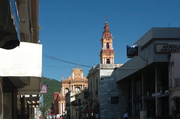
Salta is a great place to base your travels through northwestern Argentina. Joshua Zaffos
Humahuaca is a town in the foothills of the Andes with both Incan and Spanish colonial influences. Joshua Zaffos
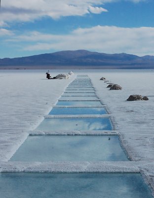
People have mined salt in the Salinas Grandes for centuries and perhaps millennia. Joshua Zaffos
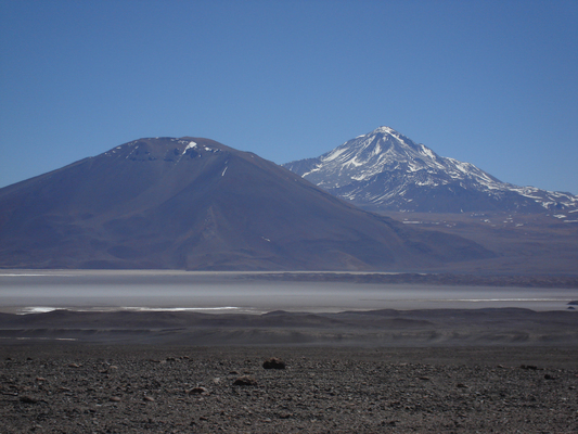
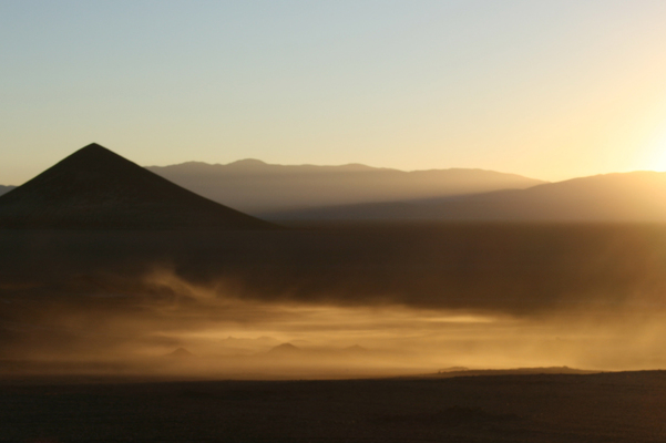
Cerro Llullaillaco towers above the Puna de Atacama. Federico Manuel Norte, fn@nortetrekking.com
The highway south from Salta toward Cafayate follows the Quebrada de Cafayate, carved by the Río de las Conchas. Federico Manuel Norte, fn@nortetrekking.com
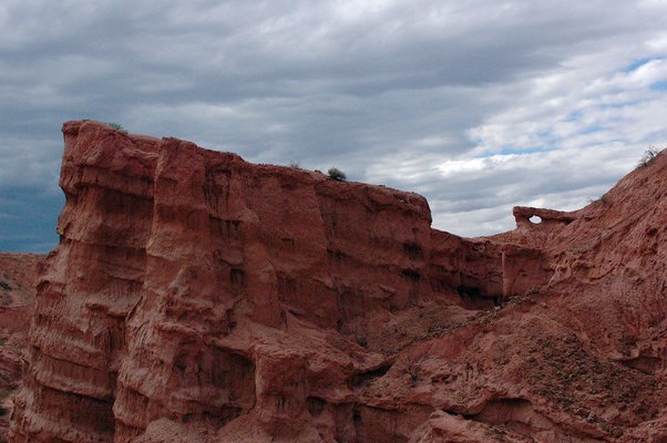
Geology along Quebrada de Cafayate. Joshua Zaffos
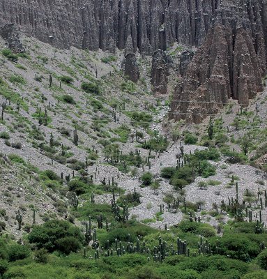
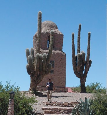
Cardón cacti along the Quebrada de Humahuaca. Joshua Zaffos
From cactus-covered deserts to cloud forests to the sky-scraping Andes Mountains, northwestern Argentina promises contrasting landscapes, astounding geological formations and natural beauty — and a chance to eat llama. So with no disrespect to the more geologically famous ice fields and mountains of the Argentine Patagonia to the south, I suggest heading north from Buenos Aires if you get a chance to explore the country.
There are several ways to explore the provinces of northwestern Argentina. My friends and I left for the provinces of Salta and Jujuy by bus, opting for deluxe accommodations: Fully reclining seats, a couple of near-edible meals, and evening wine and morning mate (a popular South American tea made from the dry leaves of the yerba mate plant) were all included. The trip lasted 20 hours and wasn’t too bad. For a few bucks less, other bus options cut out meals and reclining seats. We chose to fly back for a little more money.
We arrived in Salta, a city of 460,000 people at the foothills of the Andes. Salta is the ideal place to start your exploration of northwestern Argentina. Founded in 1582, the city’s main plaza preserves its Spanish colonial history in the architecture of its churches and other buildings. Before the Europeans arrived, the Inca inhabited the region, regarding the looming Andes, some more than 6,000 meters above sea level, as gods that watched over them. While visiting Salta, check out the archaeological museum, which houses an exceptional collection of Incan artifacts — including the remains of several Inca children who were sacrificed to the mountain gods, mummified and left atop Cerro Llullaillaco (a nearby volcano) hundreds of years ago. A climbing party discovered the mummified remains in 1999 atop the volcano’s peak, after they had melted out of a glacier.
You can base your stay in Salta and take day trips, or stay a couple of days in the city and then head out to the rugged surroundings by bus or rental car. Just about any route out of town will eventually take you through a quebrada (Spanish for “broken,” or “break”), a canyon cut into the earth by waters that produce wide alluvial fans. Roads follow the quebradas, providing spectacular views of the landscape and geology, from valleys to mountains.
The Puna de Atacama, a high plateau along the Argentina-Chile border, soars above the desert surroundings outside of Salta. The subduction of the Nazca Plate under the South American Plate — which first began about 145 million years ago — has produced many active volcanoes in the Andes, a range that stretches 7,000 kilometers north to south through all of western South America. The area outside of Salta also has its fair share of volcanoes: At 6,739 meters, Cerro Llullaillaco is the second-highest active volcano in the world. Scaling its summit (or others nearby) requires mountaineering equipment, experience and/or a guide.
My friends and I chose to explore the region’s villages and surrounding terrain via car. We rented a sedan and headed north from Salta into the mountain valley, known as the Quebrada de Humahuaca, in the foothills of the Andes.
The Quebrada de Humahuaca follows the Río Grande (not to be confused with the river of the same name in the United States and Mexico) as it runs off the Puna de Atacama and then toward the north. The highway hugs its path. The gorge is relatively young — less than 2 million years old — formed by compressive tectonic forces and recent climatic conditions. Today, rare but intense storms in the arid region carve valleys and move massive amounts of sediment.
The Quebrada de Humahuaca’s wildly colorful sedimentary layers and the pinnacles and crags jutting from the valley slopes, studded with huge cardón cacti, present a feast for the eyes. Some people bike or hike along the gorge, retracing a centuries-old transit route through sublime terrain. The quebrada was a major prehistoric travel corridor for the Inca and those who preceded them: Hunter-gatherers first moved through the area 10,000 years ago. This cultural significance earned the Quebrada de Humahuaca its designation as a UNESCO World Heritage Site in 2003.
We spent the night in the small city of Humahuaca, where we played some three-on-three basketball with some local teenagers — the locals and national tourists are both particularly friendly, even though most don’t speak English. For a seemingly sleepy town in the open country of northern Argentina, Humahuaca has plenty of hostels and lodging mixed with its markets, cafés and restaurants. With both Incan and Spanish influences, the region’s character differs greatly from cosmopolitan Buenos Aires: A dinner of beef, llama (lean and kind of sweet), and empanadas stuffed with goat cheese and quinoa gave us a taste of both cuisines.
Heading back south the next day, we stopped at the village of Purmamarca, renowned for its Hill of Seven Colors. The spectrum of pink, red, gray, blue, green, brown and white rock represents ancient layers of sea, lake and river sediment. Visitors can hike around and above town on trails and also explore the sunny, dusty streets.
A highway leading west from Purmamarca leads to the Puna de Atacama and the Salinas Grandes, blinding salt flats that stretch 1,500 square kilometers, about one-third the size of the Great Salt Lake in Utah. The former flat and wide marsh evaporated about 12,000 years ago as the regional climate became cooler and drier. Not far from the prehistoric lagoon, we spotted vicuñas — wild cousins of llamas — along the road. Activities seem limited to wandering the flats, but tourists amuse themselves with photo opportunities and watching laborers mine salt.
Hunter-gatherers, the Inca, Spanish colonials and modern Argentines have all mined the salinas for salt. Industrial interests have coveted and exploited mineral riches of these provinces since European settlement. Presently, plans to mine for silver and uranium have drawn opposition from locals.
After a night back in Salta, we drove south toward the town of Cafayate. Torrontes grapes, which produce the aromatic white wine of Argentina, thrive on the high slopes around the village. The landscape and the vineyards give Cafayate the feel of an unspoiled piece of California wine country.
The highway follows the Quebrada de Cafayate, carved by the Río de las Conchas. There are sweeping vistas of mountains and cloud forests, or deserts and cactus groves, depending on the turn the road takes. A number of bizarre sandstone features, eroded by the fierce winds, with names like the Monk, the Toad and the Obelisk, are easily accessible from roadside pullouts. The Devil’s Throat and the Amphitheater are both wide-open side ravines that are popular stops where locals sell crafts, meats and cheeses, and tourists can climb around the features. It’s a beautiful drive, and travelers can jump out of their vehicles to wander up washes or stick their feet in the river in many spots along the road.
Another option for taking in the region’s terrain is a ride on the Tren a las Nubes (Train to the Clouds), a breathtaking round-trip train ride that leaves from Salta and passes through the Quebrada del Toro before crawling up the Puna de Atacama. However, repairs have suspended the train schedule in recent years, and a few Argentines told us the 15-hour trip is too long despite the sights.
Keep in mind that summer in Argentina (December through March) can get crowded, but the northern regions mostly attract nationals on vacation, so it’s definitely worth the effort. By train, rental car, bus or a dedo (hitchhiking, another popular way to get around the area), it’s hard to set out in a wrong direction in northwestern Argentina.
© 2008-2021. All rights reserved. Any copying, redistribution or retransmission of any of the contents of this service without the expressed written permission of the American Geosciences Institute is expressly prohibited. Click here for all copyright requests.