
by David B. Williams Thursday, January 5, 2012
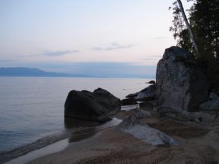
Lake Baikal David B. Williams
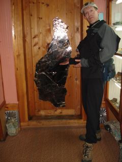
Williams displays a giant specimen of mica from Sludyanka, Russia. David B. Williams
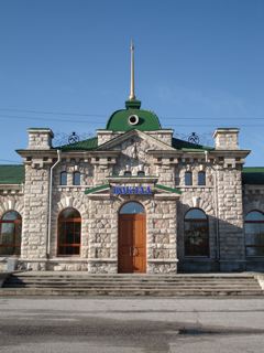
The all-marble train station at Sludyanka, Russia. The white-blue marble comes from quarries outside of town. David B. Williams
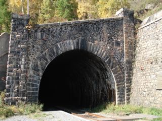
A tunnel on the Circumbaikal train route, the last-completed section of the Trans-Siberian Railway. David B. Williams
Deepest. Oldest. Most biologically diverse. Siberia’s superlative-laden Lake Baikal is one of the planet’s great geological treasures. Located 4,200 kilometers east of Moscow and 2,100 kilometers west of Vladivostok, the lake known locally as the Sacred Sea is like no other.
To reach Baikal, you can fly to Irkutsk, Russia, the biggest city near the lake. The more picturesque way to get to Baikal, however, is to take the Trans-Siberian Railway. From Moscow in the west, it is a five-day trip; from Vladivostok to the east on the Pacific Ocean, the journey lasts 60 hours. Formerly the home of the Soviet Union’s Pacific Fleet and a city closed to foreigners from 1958 to 1992, Vladivostok has recently started to thrive, hosting tourists from China, Japan and Korea.
The Trans-Siberian travels north and west from Vladivostok along Russia’s borders with China and Mongolia, passing through rolling hills and broad river valleys. Periodically, forlorn-looking towns appear and disappear in seconds (causing one to wonder what people do out here). The vegetation ranges from the grassland plains of the open steppes to the taiga forests of birch, Siberian larch, and Siberian pine. Coming from the east, the closest large train station to Baikal is two hours away at Ulan Ude, a city of 350,000 people, of which half are native Buryats, a Mongol group and the largest ethnic minority in Siberia.
From Ulan Ude, catch a ride in a marshrutky — a minivan used as public transportation — north to Ust-Barguzin, Zabaikalsky National Park and the Holy Nose Peninsula. But be prepared: You may be sardined in if the driver can pick up enough people — and the trip takes six hours over ruts, potholes, and occasional pavement.
In America, Ust-Barguzin would be a gateway community with tourist shops, trendy cafes, and cute B&Bs. You will find none of that here, however; most houses lack indoor plumbing, though the residents may have Internet access. Still, your best option is a homestay or hostel. A Russian non-governmental organization, the Great Baikal Trail Association, is trying to promote ecotourism. They are working to build a 2,500-kilometer-long trail around the lake and to establish a network of homestays and small hostels.
Standing on the shores of the lake in Barguzin Bay, you can begin to get a feel for the size of Baikal. At this spot, the bay stretches 30 kilometers across — about ten times the width of Lake Washington in my hometown of Seattle. If the weather is clear, you can see the far side of the lake, a faint ghost of land 80 kilometers distant. And then you look at a map and realize the bay is but a tiny blip on Baikal’s shores: the crescent-shaped lake is over 630 kilometers long.
Lake Baikal is the central feature of a massive rift zone formed between the Siberian craton and several microplates. Although controversial, a leading theory for rift onset was the oblique collision of India with Asia, which rotated China counterclockwise and began to open the basin. The northern end of Baikal is more mountainous than the south, and peaks in Zabaikalsky top out at more than 2,500 meters. Jutting out into the lake is the Holy Nose Peninsula, which rises abruptly 1,422 meters above the water. Best estimates for the age of the lake are 25 to 27 million years old, making Baikal by far the planet’s oldest lake.
The rift continues to open and to generate large earthquakes. A magnitude-7.5 quake on January 12, 1862, around the mouth of the lake’s biggest tributary, the Selenga River, dropped 200 square kilometers of the coastline by as much as two meters and made a new bay, now one of the lake’s best birding spots.
Baikal bottoms out at 1,637 meters below the lake’s surface, with an average depth of about 750 meters. Below the lake bottom is an additional 7.5 kilometers of sediment in the deepest parts of the basin. Because of the great depth and great length, Baikal contains more water than all of the Great Lakes combined, roughly one-fifth of Earth’s freshwater.
The lake’s depth and age have made it an evolutionary hot spot. More than 2,500 species, around 2,000 of which are endemic, dwell in its waters. Species include a 40-centimeter long flatworm, 255 species of amphipods and the only freshwater seal, the nerpa. Enigmatic in origin, nerpas may have arrived at Baikal from the north during the Plio-Pleistocene. One theory holds that the seals ascended either the Angara/Enisei or Lena rivers to the lake, but evidence has not been found for their exact route.
Returning to Ulan Ude, you can catch a train (assuming you can navigate the astoundingly unhelpful information people at the station) that will take you around the south end of Baikal to the fine little village of Sludyanka. Slud is the Russian word for mica. You can find immense mica specimens, as well as dozens of other beautiful minerals, at the local mineralogical museum, a 20-minute walk from the train station. The museum gift store, funky at its best, sells many unusual specimens, including charoite, a lavender-colored silicate mineral found in only one location in Siberia. You can also buy aquamarine apatite crystals … though the owner of your hostel may laugh at you (as mine did) because you paid $12 for a two-inch-long crystal and he uses a bigger one to prop open a door.
Sludyanka is also home to a very handsome, all-marble train station. The marble comes from quarries outside of town and is white with blue undertones. Good specimens can be found on the road that runs past the mineralogical museum and up toward the quarries.
From Sludyanka, catch a train to explore the last-completed section of the 9,289-kilometer-long Trans-Siberian Railway, known as the Circumbaikal route. Finding a way across the lake took many years. Before its completion in 1904, trains traveled east up the Angara River, the lake’s only outlet, to Port Baikal, and then were put on a steamship to cross the lake. During the Russo-Japanese War of 1904-05, the Russians attempted to lay tracks across the iced-over lake, which generally freezes a meter thick. They met with little success.
Recognizing that they needed a better way around the lake, the Russians built a new track down and around the southwest corner of Baikal. Because of the steep cliffs and hard gneiss and granite, construction took more than two years and was considered both the hardest and most spectacular on the entire route. The 84-km track runs through 39 tunnels, along 47 stone galleries, and over dozens of bridges.
Ironically, a dam built in the 1950s flooded part of the tracks along the Angara, and the Circumbaikal was abandoned. One train daily still travels the route to Port Baikal, however. Aimed at tourists, the train moves along at a leisurely pace, stopping regularly so that travelers can investigate the stone work of the tunnels and galleries. Many of the masons came from Italy and the rock structures are engineering at its finest. The views across the lake are some of finest, too.
Lake Baikal is a landscape that is nearly impossible to fully appreciate. Its tremendous depth and diversity cannot be seen. Nor is there any place to experience its great length. Its beauty does not hit you over the head, but time spent at Baikal is a one of a kind experience for anyone who is geologically inclined.
© 2008-2021. All rights reserved. Any copying, redistribution or retransmission of any of the contents of this service without the expressed written permission of the American Geosciences Institute is expressly prohibited. Click here for all copyright requests.