
by Terri Cook Friday, January 30, 2015
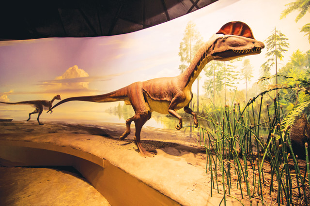
Dinosaur State Park in Rocky Hill, Conn., features more than 2,000 dinosaur footprints, one of the largest trackways ever discovered. The tracks were likely made by dilophosaurs, which grew to about 2 meters tall, 5.5 meters long, and weighed about 275 to 320 kilograms, as demonstrated by the park museum's life-size model. Credit: ©Rain0975/kellyv, CC BY-ND 2.0.
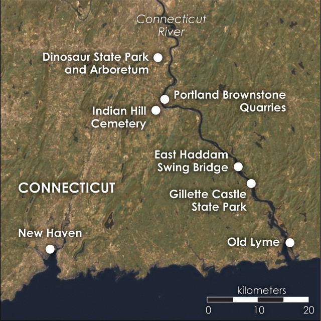
Sightseeing destinations in the lower Connecticut River Valley. Credit: Kathleen Cantner, AGI.
In August 1966, bulldozer operator Edward McCarthy was excavating the basement of a new state building near Rocky Hill, Conn., when he made a startling discovery: a large, three-toed track imprinted in a slab of gray sandstone. Careful excavation soon revealed that this print was part of one of the largest dinosaur tracksites in North America. Word of the discovery spread quickly, and within a few weeks, the entire site — including more than 2,000 prints embedded in Early Jurassic-age rock — was preserved as Connecticut’s Dinosaur State Park.
The park is located near the sinuous Connecticut River, which winds gracefully through an elongated, north-south depression stretching from northern Massachusetts to Long Island Sound. This geographic “Central Valley” existed long before the river began to flow here; it is the remnant of an ancient rift valley that initially formed during the Triassic Period, about 220 million years ago. The story of its formation is inextricably linked with that of the dinosaur tracksite — and the demise of the supercontinent Pangea.
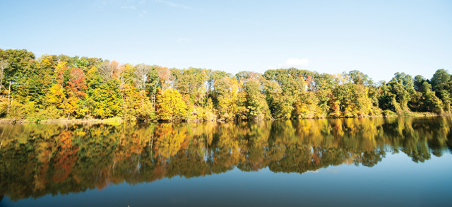
The Connecticut River flows through a failed rift valley that formed as Pangea was breaking up during the Triassic. Credit: Brian Scantlebury, Fotolia.
The story of the Connecticut River Basin and its famous footprints begins with the breakup of Pangea. This protracted event began during the Late Triassic Period after Connecticut had been locked in the interior of the vast landmass for tens of millions of years.
In response to mantle upwelling, a rift system developed along the suture zone between the future African and North American continents. Geologists believe this system, like the modern East African Rift, included a series of uplifted highlands adjacent to down-dropped valleys called “grabens” (from the German word for graves) that stretched along the modern Atlantic coast.
Although multiple grabens formed between Africa and North America, only one continued to widen and deepen enough to flood and ultimately create the Atlantic Ocean, which is still expanding today. Extension in the other valleys eventually ceased, leaving behind a series of what geologists call “aborted rifts” stretching from Nova Scotia to South Carolina. These aborted rift valleys gradually began to fill with sediments interlayered with dark volcanic rocks, which originated as magma tapped by deep, rift-related faults. This collection of rift-valley-fill rocks, collectively called the Newark Supergroup, has provided geologists with a record of what the region’s environment, climate and geography were like during the Early Mesozoic, as Pangea was breaking apart.
At 140 kilometers long and 30 kilometers wide, central Connecticut’s Hartford Basin, a topographic low where the Connecticut River later began to flow, is one of these aborted rifts. Between 220 million and 195 million years ago, the basin collected about 4 kilometers of lithified sediment and volcanic rock. Recent research indicates that during this time the basin was located between 7 and 12 degrees north paleolatitude, and that the region’s climate changed from arid to humid by the Early Jurassic, when the dinosaurs imprinted their tracks.
Highlands east of the graben were composed of Paleozoic crystalline (igneous and metamorphic) rocks. Powerful rivers swollen by rainy-season cloudbursts eroded the highlands and carried the resulting sediment westward across the basin’s eastern fault scarp, depositing it in alluvial fans in the rift valley below. The alluvial fans stretched westward to meet perennial lakes that formed in the valley during wetter periods. Paleontologists believe that it was along the shore of one such lake that the dinosaurs once roamed, leaving the tracks McCarthy accidentally uncovered.
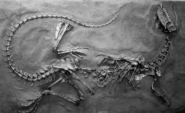
A mounted cast of a Dilophosaurus skeleton discovered in 1942 on display at the Navajo Nation Museum in Window Rock, Ariz. Credit: Terri Cook and Lon Abbott.
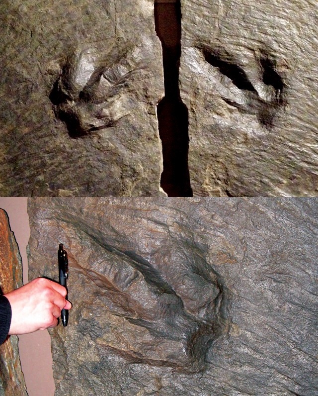
This type of three-toed track, first discovered elsewhere in Connecticut in the 1830s, was named Eubrontes giganteus, meaning "enormous true thunder." Credit: above: Terri Cook and Lon Abbott; below: Sara E. Pratt.
It was elsewhere in Connecticut, in the 1830s, that footprints of this type were first studied. In 1836, Reverend Edward Hitchcock began a detailed investigation of tridactyl footprints (three-toed tracks characteristic of meat-eating dinosaurs) fossilized in another Connecticut stone slab. The birdlike tracks were enormous, up to 38 centimeters across. The Reverend named them Eubrontes giganteus, meaning “enormous true thunder.” Hitchcock’s use of a Latin name inaugurated the practice that continues today of assigning genus and species names to sets of tracks, usually independently of the species that made them, which is often not known.
Like everyone else at the time, Hitchcock assumed that a large bird had made the tracks; the term “dinosaur” would not be coined until six years later. But over the next several decades, as he studied thousands of additional fossilized footprints unearthed across the eastern seaboard, he came to realize that dinosaurs had indeed made them.
From the prints, he inferred many details about the anatomy of the trackmaker. Tracks and bones combined provide complementary information, but only rarely are the two found together or can they be confidently linked. The identity of the Eubrontes trackmaker remained a mystery for more than a century. Then, in 1942, Sam Welles, a University of California paleontologist, discovered the remains of three large dinosaurs just 375 meters from several Eubrontes tracks near Moenave, Ariz. Welles named the dinosaur Dilophosaurus, meaning “double-crested reptile,” and noted that its foot was perfectly suited for making the Eubrontes tracks.
The discovery was particularly significant because it filled a major gap in the fossil record of dinosaur life during the Early Jurassic, when the animals came to dominate terrestrial ecosystems around the globe.
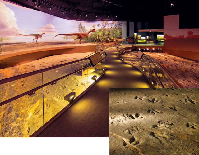
As visitors stroll through the Dinosaur State Park exhibit hall on elevated walkways, the lighting continuously changes to make the more than 500 different trackways more visible. Credit: tracks: Terri Cook and Lon Abbott; walkway: ©Rain0975/ kellyv, CC BY-ND 2.0.
Dinosaur State Park preserves two Eubrontes track-bearing exposures. One, called “The Trackway,” is enclosed inside a building and is accessible to visitors year-round. The second, larger exposure was reburied to preserve its fragile prints; only the marked corners are still visible to the east of the exhibit center.
The Trackway is, at first glance, a confusing hodge-podge of large (25 to 40 centimeters long), tridactyl marks scattered across an area nearly the size of a football field. Single footprints and trackways six or more prints long reveal snapshots of these prehistoric creatures’ lives as they tramped across a soggy lakeshore. The prints in each trackway are nearly the same size and shape, indicating they were made by dinosaurs walking the same way, erect on their hind feet.
Dilophosaurus, the likely trackmaker, is thought to have been the biggest, fiercest carnivore of its time. As the museum’s life-size model demonstrates, full-grown dilophosaurs stood about 2 meters tall, stretched 5.5 meters long, and weighed 275 to 320 kilograms. The function of the double head-crest is not known; it may have served to intimidate rivals or attract potential mates. Dilophosaurs were amply armed for combat with rows of jagged teeth and sharp claws, the imprints of which you can still see in several of the tracks. Based on measurements of the spacing between prints from other locations, paleontologists estimate that Dilophosaurus was capable of running up to 24 kilometers per hour over short distances, but at Dinosaur State Park, the more closely spaced tracks indicate they traveled across this ancient lakeshore at much slower speeds, just 5 to 8 kilometers per hour.
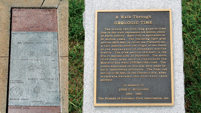
A trail outside the exhibit center leads visitors on a walk through geologic time. Credit: left: Terri Cook and Lon Abbott; below: Sara E. Pratt.
There is a lot of variability in the tracks’ degree of preservation at the state park; some of the more than 500 tracks in the sandy mudstone of the East Berlin Formation are mere smudges, but others preserve more detail, including claw marks. In truth, we are lucky to see anything at all; scientists’ ability to study dinosaurs and other extinct creatures depends entirely on nature providing the necessary conditions. (Preserving bones is even more difficult; intact skeletons like those found near Moenave are extremely rare — only one other dilophosaur skeleton has ever been found.)
Tracks like those at Dinosaur State Park can be preserved in two different ways. The “cover-up” method occurs when an animal makes a print in sediment that is moist but not completely saturated. If the print dries out and hardens, and then is quickly buried by an influx of sediment — say, from a flood — it might be preserved. Alternatively, if an animal is heavy enough to make an impression not just on the surface but also in underlying layers, these already-buried imprints, called “underprints,” stand a greater chance of long-term preservation. Most of the prints exhibited in the park are underprints.
Even if tracks are fortuitously preserved, however, they might never be reexposed. The sediments hosting the prints must be buried deeply enough to be lithified into rock, but not so deeply that they are metamorphosed. Erosion must then take over, stripping off enough overlying rock to reveal the host layer, as well as removing the grains that originally filled the fragile prints.
In contrast to many other tracksites, the Eubrontes prints at Dinosaur State Park have no preferred orientation; the dilophosaurs that made them appear to have been rambling, changing direction often as they walked. The evidence suggests these prints were made by individuals or perhaps small groups of dilophosaurs, and their varying degree of preservation suggests they may have been imprinted over a relatively long interval spanning weeks or even months.
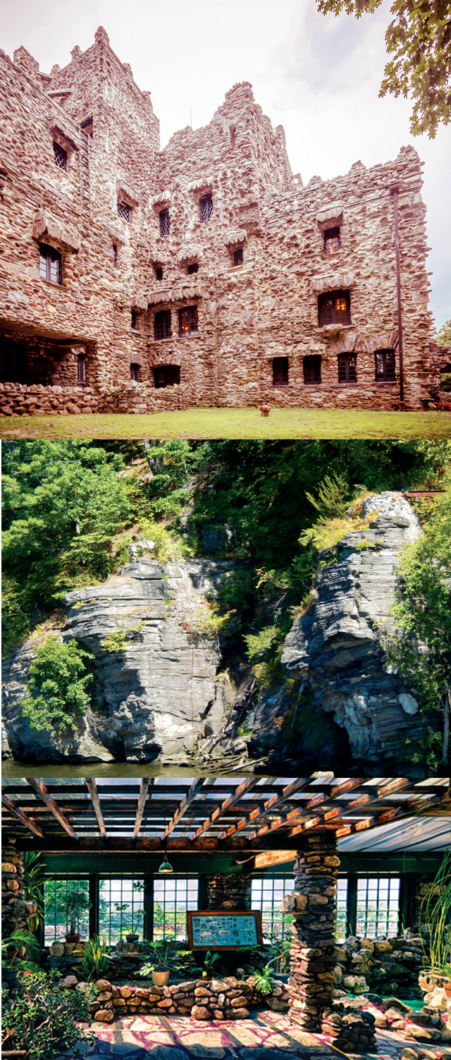
Gillette Castle (top), a 24-room mansion overlooking the Connecticut River that was designed to look like a medieval stronghold, was built of local metamorphic stone. On the riverbank below the castle lie large outcrops of black-and-white-banded gneiss of the Hebron Formation (middle). Visitors can tour the interior of the castle, including the greenhouse (bottom). Credit: top: alex9500, Fotolia; middle: Terri Cook and Lon Abbott; bottom: ©Rain0975/kellyv, CC BY-ND 2.0.
As you ramble around the rest of the Connecticut River Valley, a great way to see the sights and spoter crystalline rocks, largely gneisses and schists, present on either side of the ancient rift valley is to board the Essex Steam Train and Riverboat ride. After a puffing locomotive pulls you through quaint New England towns tucked beneath forest-clad hills, you embark on a riverboat trip up the Connecticut River to the turn-around point at the impressive 1913 East Haddam Swing Bridge, which spans the river next to the acclaimed Goodspeed Opera House in East Haddam, Conn.
High above the river near the midway point stands Gillette Castle, a 24-room mansion designed to look like a medieval stronghold. Built of local metamorphic stone by eccentric actor, director and playwright William Gillette, the castle is now part of Gillette Castle State Park, also in East Haddam. Along the riverbank below the castle lie large outcrops of black-and-white-banded gneiss of the Hebron Formation, which dates to the Silurian and Ordovician periods.
Also along the Connecticut River, you can visit the former Portland Brownstone Quarries, in Portland, Conn., a National Historic Landmark. The quarry once served as an important source of the reddish-brown arkose sandstone, called “brownstone,” that was used extensively to build row houses (still called “brownstones”) and other structures during the second half of the 19th century. Part of the Early Jurassic Portland Formation, this rock comprises the Hartford Basin’s youngest unit, deposited after dinosaurs had already left their tracks in the slightly older East Berlin Formation exposed at Dinosaur State Park.
The Portland brownstone is another important source of footprints and other fossils in the Connecticut River Valley. One unique example is located in Middletown’s Indian Hill Cemetery on the gravestone of Dr. Joseph Barrett, a botanist and avid mineral and fossil collector. When Barrett died in 1882, quarries donated two brownstone slabs to mark his gravesite. The upper piece features the doctor’s epitaph on the front and several dinosaur prints (Grallator formosus and Brontozoum sillimanicum) on the back. The lower piece contains two fossil tree casts, as well as the inscription, “The Testimony of the Rocks” — a seemingly prescient tribute to the scientific discoveries that would eventually lead scientists to link the valley’s unusual fossils to the formation of a deep sedimentary basin during the death of a supercontinent.
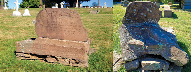
The brownstone gravestone of Dr. Joseph Barrett, a botanist and avid mineral and fossil collector who died in 1882, features several dinosaur footprints and two fossil tree casts. Credit: both: Terri Cook and Lon Abbott.
© 2008-2021. All rights reserved. Any copying, redistribution or retransmission of any of the contents of this service without the expressed written permission of the American Geosciences Institute is expressly prohibited. Click here for all copyright requests.