
by Terri Cook Friday, May 16, 2014
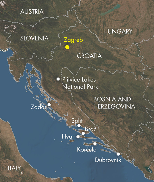
Lying at the crossroads of Southern Europe and the Mediterranean, the Republic of Croatia could be called a “land of limestone.” Whether you choose to circumnavigate the fortified walls of one of Europe’s best-preserved medieval cities, lounge on a white cobble beach by the azure Adriatic Sea, or hike past aquamarine pools and countless waterfalls in the country’s largest national park, Croatia’s nearly ubiquitous limestone bedrock produces a majestic and unforgettable landscape.
Limestone is composed of the mineral calcite, itself built from ions of calcium and carbonate. Limestone and dolomite, limestone’s magnesium-rich cousin, comprise the dominant bedrock throughout the Balkan Peninsula. An important characteristic of limestone is that it is easily dissolved along fractures and bedding planes by the natural acidity of rain and groundwater, which gradually enlarges cavities. This, in turn, allows more water to pass through, eventually producing underground drainage systems that include caves, sinkholes, disappearing streams and springs that seem to appear out of nowhere. This distinctive type of topography is known as karst, and Croatia is where such terrain was first described. Along with the rest of the Balkans, Croatia offers what is considered the world’s best example of temperate karst geology.
Formerly part of Yugoslavia and still emerging from the fierce 1991–1995 War of Independence, Croatia is not as well known as many Western European destinations. Since joining the European Union in 2013, however, Croatia’s prospects for tourism have grown. With a surfeit of sunny Mediterranean islands, scenic hiking and coastal cycling, quaint medieval towns and seaports, and fresh seafood and local beer, Croatia has emerged as an alluring geo-destination.
Credit: Kathleen Cantner, AGI.
The Balkan Peninsula is a large and mostly mountainous region stretching from the Adriatic Sea to the Black Sea. Croatia is located on the western side of the peninsula in the Dinarides (also called the Dinaric Alps), a series of roughly parallel ranges that stretch along the Adriatic’s east coast from Albania to Slovenia. Formation of the Dinarides began about 200 million years ago during the breakup of the supercontinent Pangaea when a rift formed between two great landmasses, Laurasia to the north and Gondwana to the south. This rift gradually grew into the Tethys Sea, the floor of which was blanketed by thick shallow marine carbonates during the Mesozoic era.
As Pangaea continued to split apart, Earth’s plates slowly reorganized themselves. Broadly speaking, the northward movement of Africa created a series of subduction zones along the Tethys Sea’s northern edge, culminating in a series of continental collisions during the Cenozoic that uplifted the Tethyan limestones into the southern Alps, Italy’s Apennine Mountains and the Dinarides.
The details of these tectonic interactions are complex. Geologists generally agree that Adria was a promontory of Africa from the Jurassic to the Cretaceous, after which it broke off the African Plate, creating a “microplate” known as Adria, which subsequently collided with the Eurasian Plate. Several million years ago, counterclockwise rotation of Adria appears to have caused strike-slip motion to emerge along Adria’s eastern boundary, helping to shape the modern Dinarides. However, researchers are still debating the specifics of these interactions, including whether Adria behaved as one coherent block or two separate ones. Such uncertainties hamper geologists’ understanding of central Mediterranean tectonics and influence modern-day applications like seismic and tsunami hazard prediction.
Nestled in the mountainous terrain of central Croatia, Plitvice (PLEET-veet-say) Lakes National Park is best known for its blue-green water, vigorous waterfalls, caves and a sparkling series of 16 deep pools that are so clear you can see scores of fish darting in their depths.
These are classic features of karst topography. Throughout the region, you’ll also notice the relative lack of surface water, which is another distinctive karst feature — any moisture that falls on the ground quickly enters the underground plumbing.
The groundwater is loaded with dissolved calcium and carbonate ions, and whenever it emerges at a spring or is agitated at a cascade or waterfall, it loses dissolved carbon dioxide. This reverses the chemical reaction that dissolved the limestone in the first place, causing calcite to precipitate out of the water as travertine. Calcite precipitation from these agitated waters, aided by bacterially mediated chemical reactions, formed each of the travertine dams that confine Plitvice’s lakes. The addition of new travertine slowly modifies each lake and waterfall, continually reshaping Plitvice’s ever-changing vistas.
Thanks largely to its fantastic display of temperate zone karst, Plitvice Lakes National Park was one of the first natural sites to be added to the UNESCO World Heritage List in 1979. Its nearly 300 square kilometers also host a tremendous diversity of flora and fauna. European brown bears, wolves, lynx and European polecats inhabit the virgin beech- and fir-forested landscape, while more than 75 butterfly and 150 bird species, including Golden Eagles and Eurasian eagle-owls, take to the air. Some 55 species of orchids have also been identified in the park.
Located along an important historic transportation route, the Plitvice Lakes region has been inhabited for thousands of years by a series of settlers, including the Illyrians, Celts, Romans, Ostrogoths and Turks. More recently, on Easter Sunday 1991, Plitvice was the site of the outbreak of Croatia’s War of Independence with Yugoslavia, when the first shots were fired there resulting in the war’s first fatality.
The Serbs occupied Plitvice and the surrounding region until 1995. For years, both sides used the national park for shelter, seeding the landscape with thousands of land mines. Although de-miners certified the park safe for visitors more than a decade ago, it is still wise to stay on the park’s well-maintained network of established trails.
About 150 kilometers southwest of Plitvice, the narrow strip of shore from Zadar to Dubrovnik is known as the Dalmatian Coast. Blessed with copious sunshine, sheltered beaches and more than a thousand islands and inlets, Dalmatia has become Eastern Europe’s Riviera. Diving, snorkeling, kayaking and yachting are all popular activities.
The name of this historic region, for which the endearing breed of black-and-white dogs is named, most likely originates from the ancient Dalmatae tribe. Geologically, the Dalmatian Islands are the western outliers of the Dinaride Mountains. Geographically, this coastal strip is the type example of a “Dalmatian coastline,” an unusual type of “drowned” coast that features mountain ridges running parallel to the sea. Dalmatian coastlines form when sea level rises or land subsides, causing the sea to invade low-lying areas. This flooding converts valleys into sounds and isolated ridges into long, narrow chains of offshore islands.
One of the most enjoyable aspects of exploring the Dalmatian Coast is discovering each island’s distinctive character and history. A great place to start is Brač, Dalmatia’s largest island, which is a one-hour ferry ride from Split, the region’s largest city. Brač’s tallest peak, Vidova gora, rises to 778 meters, making it the highest in the Adriatic and a wonderful day hike. Brač is best known for an unusual white sand beach on its southern shore called Zlatni Rat, near the town of Bol. Most of Croatia’s beaches are composed of limestone pebbles and cobbles; sandy beaches like Zlatni Rat are rare because sand-sized particles of limestone dissolve so quickly.
In addition to tourism, Brač is well known for its goat cheese, wine and olive oil, as well as its famous quarries of gleaming white, coarse-grained limestone, visible along the road from Supetar to Bol. The limestone is also found in the local artwork on display at the Stone Carving School in Pučišća, where the stone is still quarried. For at least 2,000 years, Brač has been the source of limestone for important buildings and monuments, including Diocletian’s Palace in Split and the White House in Washington, D.C.
The island of Korčula is famous as the reputed birthplace of Marco Polo, whose former house in the walled old town has been converted into a museum. Hvar Island is known for fragrant lavender fields, luscious wines and a relaxed atmosphere. Around the bustling harbor of Hvar, a long string of colorful cafes welcomes travelers disembarking from their boats. Stunning views of adjacent islands and sleek yachts bobbing in the brilliant blue Adriatic far below can be had from the 16th-century, Venetian-built citadel that looms over the town.
A southbound tour of the Dalmatian Coast will eventually lead you to Dubrovnik, nicknamed the “Pearl of the Adriatic.” The old walled city is a highlight of any visit to Croatia. Founded by Greek sailors, the city-state rose to prominence as a sea power in the 13th century. Through shipbuilding and maritime trade, particularly of salt, Dubrovnik became prosperous and used its wealth and skillful diplomacy to resist the control of Venice and other dominant Mediterranean powers.
Dubrovnik has also experienced its share of misfortunes. In 1806, Napoleon’s army besieged the city, peppering it with more than 3,000 cannonballs, and in 1991, the Yugoslav National Army laid siege to this historical treasure for eight months.
In addition to the ravages of war, the town was seriously damaged by an earthquake in 1667, and concern is rising that another destructive earthquake could strike the region. In 2008, scientists led by Richard Bennett at the University of Arizona identified a new thrust fault, at least 200 kilometers long, running under the sea northwest of Dubrovnik. Until this discovery, geologists had assumed that the tectonic action that created the Dinarides had ceased 20 million to 30 million years ago.
Researchers now know that the southern portion of the Adria microplate continues to slide beneath Eurasia, scraping off and uplifting the overlying limestone — and building more Dalmatian islands in the process. This continued tectonism is slowly causing Italy’s heel to slide toward Dalmatia at a rate of about 0.4 centimeters per year. If it continues, the Adriatic Sea could close up in the next 50 million to 70 million years.
Fortunately, Dubrovnik’s history has taught its citizens to live in the present, and the residents’ upbeat attitude is easy to sense when visiting this lovingly restored city. Do not miss the opportunity to stroll around the top of the old town’s impressive limestone walls for incredible views of nearby Lokrum Island and the town’s beautiful churches, palaces, fountains and vivid orange roofs. Within the encircling walls are many interesting attractions, including historic mansions, a Homeland War Museum and the Old Pharmacy, which has been in business since the Middle Ages.
The Stradun, Dubrovnik’s main promenade, hosts colorful market stalls by day and small tables at night, where you can enjoy candlelit meals beneath towering limestone walls in the heart of the world’s foremost temperate karst geology.
© 2008-2021. All rights reserved. Any copying, redistribution or retransmission of any of the contents of this service without the expressed written permission of the American Geosciences Institute is expressly prohibited. Click here for all copyright requests.